
What You Missed
Fall 2012
Fall 2012
![]()
![]()
![]()
![]()
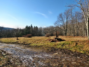
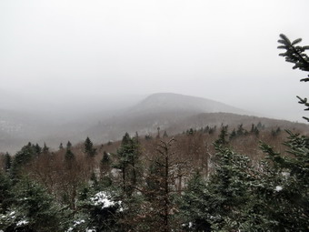
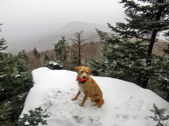
![]() On Thursday, December 20th I wanted to get out and hike close to home before track practice. I had been to the Frick Pond and Trout Pond areas recently so I decided to head to Long Pond on this cold but clear day. We finally got out of the house before 9:00 AM and were actually at the trailhead and ready to hike by 8:45 AM. We left the parking area and crossed the bridge on the snowmobile and hiking trail. There was a dusting of snow on the ground which increased a little with elevation but was never more than an inch. The temperature was in the high 20's but I had decided to forgo tights under my Mountain Hardwear Winterwander pants. Over the first .7 miles the trail gains about 370 feet in elevation. This is certainly not the kind of climb that is found on many 3500 foot peaks but it is enough to start to warmup. By the time we got to the top of the climb, I was ready to open up the pitzips on my Mammut Hoody and the front zippers on my shirts. Sheila was happy to be out and was running up and down the trail and following some animal trails into the woods. The walk to the spur trail to the pond went quickly and by 9:15 AM we were on the shore of Long Pond. The path to the edge of the pond was very muddy and I was afraid Sheila would be unable to resist. I put Sheila on her leash and tied her to a log while I walked out carefully to take some pictures. Unfortunately the sun was directly across the pond and at an angle where it could not be avoided. I did take a few shots to the left and right but the day was somewhat bleak with only an overcast sky. After a few shots, I returned to Sheila and we walked back up to the main trail.
On Thursday, December 20th I wanted to get out and hike close to home before track practice. I had been to the Frick Pond and Trout Pond areas recently so I decided to head to Long Pond on this cold but clear day. We finally got out of the house before 9:00 AM and were actually at the trailhead and ready to hike by 8:45 AM. We left the parking area and crossed the bridge on the snowmobile and hiking trail. There was a dusting of snow on the ground which increased a little with elevation but was never more than an inch. The temperature was in the high 20's but I had decided to forgo tights under my Mountain Hardwear Winterwander pants. Over the first .7 miles the trail gains about 370 feet in elevation. This is certainly not the kind of climb that is found on many 3500 foot peaks but it is enough to start to warmup. By the time we got to the top of the climb, I was ready to open up the pitzips on my Mammut Hoody and the front zippers on my shirts. Sheila was happy to be out and was running up and down the trail and following some animal trails into the woods. The walk to the spur trail to the pond went quickly and by 9:15 AM we were on the shore of Long Pond. The path to the edge of the pond was very muddy and I was afraid Sheila would be unable to resist. I put Sheila on her leash and tied her to a log while I walked out carefully to take some pictures. Unfortunately the sun was directly across the pond and at an angle where it could not be avoided. I did take a few shots to the left and right but the day was somewhat bleak with only an overcast sky. After a few shots, I returned to Sheila and we walked back up to the main trail.
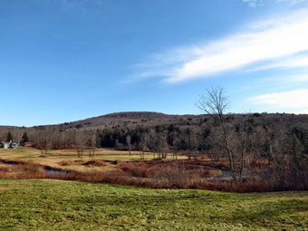 As we approached the first trail junction, I decided to do the long loop so we turned right and headed out toward the trail to the lean-to. I was going to put Sheila back on her leash as there are several areas that have small ponds but she stayed right next to me and out of the muddy water. The hike at this point was relatively flat and the walk went quickly. By 9:50 AM we had walked 2.5 miles and were at the woods road that forms the next part of the loop. I decided to turn right here and walk out to a field that has a view of some ridges. In the field I stopped to take some pictures and Sheila ran around following her nose. As I packed up my camera, I became curious about the destination of the road through the field. I saw no POSTED signs so we headed down through the field and followed the road through some twists and turns and down a hill. Soon a hunting camp appeared and the road end. I did not want to continue hiking on private land so we turned around and headed back to the field. I noticed that another road headed down the hill in the field and we followed that until it was clear that it only led to the other side of the hunting camp! At that point I decided to head back to the main trail to complete the loop. The walk on the woods road was a little tricky at times as there was some ice. By 10:45 AM we had walked 4.7 miles when we arrived at the small stream that crosses the road from a beaver pond. It seemed as if someone had removed part of the dam and the water was easily crossed. We walked by the Peters Hunting Camp to continue on to Basily Road. I stopped to take a few pictures of the idyllic setting before continuing on our way. The rest of the hike was on form dirt road that eventually becomes Flugertown Road and is paved. We were back at the car by 11:45 AM having covered 7.3 miles in just under 3 hours.
![]()
![]()
![]()
![]()
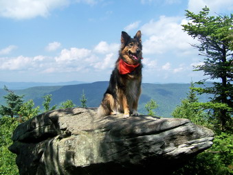
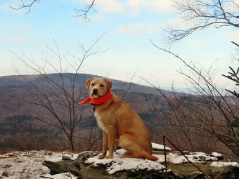
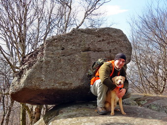
![]() On Saturday, December 15th, I decided to hike Westkill where I wanted to leave the ashes of my hiking companion Sheba. Sheba, a German Shepherd-Collie mix kept me company on virtually every hike for the last six years. She was a good friend and a great trail dog who saved my hide more than once. This passed spring she was diagnosed with Lyme Disease which made her lame in both her hips. This made it more and more difficult for her to even get around the house. I will always miss her and I think of her on very hike we take. On one hike she jumped up on a rock at the Buck Ridge Lookouts on Westkill. I had a framed canvas made of the picture to hand on the wall of my study. My son Kurt agreed to go with me so I had to wait for him to arrive with his daughter. By the time we left Livingston Manor it was about 10:30 AM and the temperature had risen to the mid-30's. I knew that I would be removing at least one layer before the hike but we got Sheila and our gear in the car and headed out. The drive to the trailhead on Spruceton Road went quickly and we were parked at just before 11:30 AM. There were several cars in the parking area at the end of the road so we parked in the next one down which was almost empty. I took off my baselayer since the temperature was no colder at the trailhead than at home. We set off up the woods road to Diamond Notch Falls. I was wondering how we might cross since the creek looked high and the foot ridge had still not been replaced. When we arrived at the falls, I saw that the place I had crossed below the falls was underwater. We investigated the area where the bridge had been and found a likely spot. We crossed there as I made not that I would take pictures of the rock formation and the falls on the way back. We turned right to get on the Devil's Path which ascends the mountain. The climb began almost immediately and I was reminded that I always forget that the hike is not an easy one. The hike up to the ridge is mostly on the north side of the mountain and there was a sprinkling of snow on the ground. The mud was frozen and that certainly was a plus. Sheila was doing her usual run back and forth on the trail with occasional side excursions.
On Saturday, December 15th, I decided to hike Westkill where I wanted to leave the ashes of my hiking companion Sheba. Sheba, a German Shepherd-Collie mix kept me company on virtually every hike for the last six years. She was a good friend and a great trail dog who saved my hide more than once. This passed spring she was diagnosed with Lyme Disease which made her lame in both her hips. This made it more and more difficult for her to even get around the house. I will always miss her and I think of her on very hike we take. On one hike she jumped up on a rock at the Buck Ridge Lookouts on Westkill. I had a framed canvas made of the picture to hand on the wall of my study. My son Kurt agreed to go with me so I had to wait for him to arrive with his daughter. By the time we left Livingston Manor it was about 10:30 AM and the temperature had risen to the mid-30's. I knew that I would be removing at least one layer before the hike but we got Sheila and our gear in the car and headed out. The drive to the trailhead on Spruceton Road went quickly and we were parked at just before 11:30 AM. There were several cars in the parking area at the end of the road so we parked in the next one down which was almost empty. I took off my baselayer since the temperature was no colder at the trailhead than at home. We set off up the woods road to Diamond Notch Falls. I was wondering how we might cross since the creek looked high and the foot ridge had still not been replaced. When we arrived at the falls, I saw that the place I had crossed below the falls was underwater. We investigated the area where the bridge had been and found a likely spot. We crossed there as I made not that I would take pictures of the rock formation and the falls on the way back. We turned right to get on the Devil's Path which ascends the mountain. The climb began almost immediately and I was reminded that I always forget that the hike is not an easy one. The hike up to the ridge is mostly on the north side of the mountain and there was a sprinkling of snow on the ground. The mud was frozen and that certainly was a plus. Sheila was doing her usual run back and forth on the trail with occasional side excursions.
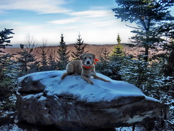
 We walked and talked and the hike seemed to go quickly. Around 12:50 PM we were at the rock overhand just below the 3500 foot sign. We were at the area where the trail turns almost due west and levels off slightly. A little further along we met a couple coming back from the summit. They told us there was another group of three women who were about ready to come down and that a hiking club was walking through to the other end of the trail. We continued on our way and were soon at the base of the final ascent. I could hear voices as we climbed and I was sure to put Sheila on her leash as a courtesy. As we emerged on the top, we met the group of three women which included my friend Connie. We said :hello" and talked briefly. A Jack Russell terrier in the group seemed to have a problem with Sheila so Hurt and I headed out for the summit. Hiking to the summit of Westkill is a short trip but serves no purpose other than to allow a hiker to claim they got to the summit. The real attraction of Westkill was back at the Buck Ridge Lookouts. Kurt and I turned around and walked back to the lookouts. The other group was just leaving. I took off my pack and got out the camera. I took pictures from the lookout on the south side including some of Kurt and Sheila. We walked over to the north side and I took some pictures from there. The trees have started to block the view and I did not want to stand on the snow-covered boulder. Sheila had no problem jumping up on the boulder for a few shots. I went back to my pack and brought out the package with Sheba's ashes. I walked back to the boulder on the north side. I spread her ashes below the boulder and said "goodbye" to my best hiking companion.
 Kurt and I got a drink and gave Sheila one. We both had snacks and shared some with Sheila. It was 1:50 PM and time for us to be starting back down the mountain. I did not want to hike out by headlamp and I did want to stop in the area of the falls. We kept a quick pace on the way down stopping only once at the rock overhang to take some pictures. There was one very icy area which is nearly vertical. I though this might give us some trouble but we found a way to negotiate it without a problem. We continued down the trail and passed Connie's group just before the falls. At the falls I sent Kurt across with Sheila while I stayed behind to take some pictures. I took some shots of the rock formations worm smooth after so many years of water erosion. The stream has actually changed its course slightly and now flows more on the northeast rather than southwest side of the bed. After taking these photographs, I crossed the stream and walked down the bank to the stream bed below then falls. From the base of the falls I took some more pictures before climbing back up the bank. The walk back to the car went quickly. We were back in the parking area at 4:00 PM having covered 6.4 miles in 4.5 hours with plenty of time allowed for photography. I was so tired I let Kurt drive most of the way home!
![]()
![]()
![]()
![]()
![]() On Thursday, December 13th I decided to again stay close to home but find another place to hike other than Frick and Hodge Ponds or Trout Pond. I had thought about Plateau and/or Sugarloaf but decided on the "closer to home option". I thought it would be interesting to visit Split Rock Lookout and then "redline" the Pelnor Hollow Trail. I had tried to get through the Pelnor Hollow Trail from Pelnor Hollow Road this summer but the briars were just too thick. At the time I vowed to return after a few frosts to see if I could walk the while trail. I got Sheila and my gear in the car and headed up the Beaverkill Road to cross over to Berry Brook Road. I parked at the Mary Smith trailhead at the apex of Berry Brook Road and about 10:30 AM and we got right on the trail. The temperature when I left the house had not hit 30 degrees and the overnight low was about 16 degrees. I dressed in my MH Winterwander pants with a pair of tights underneath. On top I had on a Mammut baselayer with a Patagonia Capilene top and my trusty Mammut hoody on top. The Mammut is my "go to" jacket as it is so versatile. It has almost no insulation but is made of Gore Windstopper. The pitzips start below the elbow and go all the way to the hem! When we started to hike, the temperature was still in the high 20's but the sun was coming out and I just knew I would be stopping to open up vents within a short period of time. We crossed the road and headed toward the power lines on the Mary Smith Trail. After entering the woods, we found that someone had run an ATV up the trail for some distance. The ATV tracks stopped where the climbs began. I stopped at this point to open up some sippers. The climb was a little steeper than I remembered and the higher we went the more snow was on the ground. Eventually the snow reached a little less than an inch near the top of the climb.
On Thursday, December 13th I decided to again stay close to home but find another place to hike other than Frick and Hodge Ponds or Trout Pond. I had thought about Plateau and/or Sugarloaf but decided on the "closer to home option". I thought it would be interesting to visit Split Rock Lookout and then "redline" the Pelnor Hollow Trail. I had tried to get through the Pelnor Hollow Trail from Pelnor Hollow Road this summer but the briars were just too thick. At the time I vowed to return after a few frosts to see if I could walk the while trail. I got Sheila and my gear in the car and headed up the Beaverkill Road to cross over to Berry Brook Road. I parked at the Mary Smith trailhead at the apex of Berry Brook Road and about 10:30 AM and we got right on the trail. The temperature when I left the house had not hit 30 degrees and the overnight low was about 16 degrees. I dressed in my MH Winterwander pants with a pair of tights underneath. On top I had on a Mammut baselayer with a Patagonia Capilene top and my trusty Mammut hoody on top. The Mammut is my "go to" jacket as it is so versatile. It has almost no insulation but is made of Gore Windstopper. The pitzips start below the elbow and go all the way to the hem! When we started to hike, the temperature was still in the high 20's but the sun was coming out and I just knew I would be stopping to open up vents within a short period of time. We crossed the road and headed toward the power lines on the Mary Smith Trail. After entering the woods, we found that someone had run an ATV up the trail for some distance. The ATV tracks stopped where the climbs began. I stopped at this point to open up some sippers. The climb was a little steeper than I remembered and the higher we went the more snow was on the ground. Eventually the snow reached a little less than an inch near the top of the climb.
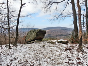
 By 11:05 AM we had hiked the 1.1 miles to the junction with the Pelnor Hollow Trail where we turned right to walk down to the Split Rock Lookout. The distance is short but the descent is steep and it was very slippery from the covering of snow. I took out my camera at the lookout and took some pictures. I decided to try to get out to the rock that has split away from the bedrock and walked to the side of the boulder. I was being careful because it was slippery and put most of my weight on a branch to stabilize myself. The branch was dead and snapped off. I am still not sure how I kept my balance and did not fall into the chasm between the rocks! I gave up on the idea of getting to the open rock face and headed back to my pack. Sheila and I walked back up to the trail junction and continued straight ahead on the Pelnor Hollow Trail to hike to the area where we had turned back during the summer. After just a short distance it was obvious someone had driven an ATV over the trail and had knocked down most of the briars. I hoped this would continue for the rest of the trail. From the trail junction we lost about 300 feet over the next .8 miles. The trail remained relatively open and easy to hike. I noticed that there were many glacial erratics along the way. We hit a low point an were about to start up the next hill when I heard a commotion and saw Sheila coming toward me with a partridge in her mouth! It was alive and she seemed vary proud as she brought it directly to me. Sheila has been wanting to catch a bird for a long time and seemed a little distressed when I demanded she drop it. The bird flew some distance away and I had to restrain Sheila from following it. We headed up the next hill and at some point near the top things started to look familiar. We had reached the point where we had stopped in the summer. I decided that since we still had time and the trail was still open we would hike to the lean-to and turn around. The hike down the other side to the lean-to had a few more prickers and did not seem to be cleared as well as the other sections. There was also some blowdown along the way. We reached the lean-to at 12:35 PM after hiking 3.7 miles and dropping 465 feet from the top of the last hill. There wasn't much to see at the lean-to so we turned around and started back. On the way back I noticed that climbing up into the pickers was a little more difficult than climbing down! The trip back was uneventful except for the fact that the temperature increased and made me even warmer. We hit the trail junction at 1:45 PM about 6 miles into the hike. We turned right and headed back to the car arriving at 2:20 PM having covered 7.2 miles in 3 hours and 45 minutes. I was surprised that the vertical gain was 1844 feet!
![]()
![]()
![]()
![]() On Tuesday, December 11th I wanted to get some exercise without going too far from home so I decided to once again go to Frick and Hodge Ponds. I got my gear and ushered a highly excited Sheila into the car. As we started out the temperature was in the mid-30's and I decided to wear my regular hiking pants and a softshell over a long sleeved shirt. As we got out of the car at the parking area at 10:00 AM , I noticed that the temperature was barely 30 degrees and a stiff breeze was blowing. I knew that I would warm up on the trail but was glad I had brought a hat and gloves. We started out on the Quick Lake Trail to Frick Pond. As soon as we made the turn onto the woods road by the register, it was obvious that this was going to be a very wet hike. Two days of rain had flooded the trails and there was standing water in some places with running water in others. We did not stop at the pond as we crossed the bridge. The day was overcast but not very interesting photographically. Also, the did was blowing and I was getting colder. Sheila took a dip in the pond and I thought she might be cold but it did not seem to bother her. I decided not to take pictures but to just enjoy the walk at as fast a pace as seemed comfortable. After only a short distance, we ran into the first of what would be over a dozen blowdowns that we had cleared several weeks before. As we continued on the trail, it was a pleasure to hike unimpeded by the trees that once blocked the way! When we got to Iron Wheel Junction, we decided to do the big loop up to Hodge. We made the left turn to continue on the Quick Lake Trail and almost immediately found a tree across the trail. As we continued toward Junkyard Junction, we found at least six more areas that need to be cleared. There were even some new trees across the trail since the last time we hiked the loop. The snowmobilers usually do a good job on this section of trail but it would be ideal to get these areas cleared
sooner than later. The higher we went in elevation the more snow we found on the trail. The snow started as just a dusting but the highest elevations had almost and inch! The trail continued to be wet and muddy in places but we were soon at Junkyard Junction where we turned right to get on the Flynn Trail.
On Tuesday, December 11th I wanted to get some exercise without going too far from home so I decided to once again go to Frick and Hodge Ponds. I got my gear and ushered a highly excited Sheila into the car. As we started out the temperature was in the mid-30's and I decided to wear my regular hiking pants and a softshell over a long sleeved shirt. As we got out of the car at the parking area at 10:00 AM , I noticed that the temperature was barely 30 degrees and a stiff breeze was blowing. I knew that I would warm up on the trail but was glad I had brought a hat and gloves. We started out on the Quick Lake Trail to Frick Pond. As soon as we made the turn onto the woods road by the register, it was obvious that this was going to be a very wet hike. Two days of rain had flooded the trails and there was standing water in some places with running water in others. We did not stop at the pond as we crossed the bridge. The day was overcast but not very interesting photographically. Also, the did was blowing and I was getting colder. Sheila took a dip in the pond and I thought she might be cold but it did not seem to bother her. I decided not to take pictures but to just enjoy the walk at as fast a pace as seemed comfortable. After only a short distance, we ran into the first of what would be over a dozen blowdowns that we had cleared several weeks before. As we continued on the trail, it was a pleasure to hike unimpeded by the trees that once blocked the way! When we got to Iron Wheel Junction, we decided to do the big loop up to Hodge. We made the left turn to continue on the Quick Lake Trail and almost immediately found a tree across the trail. As we continued toward Junkyard Junction, we found at least six more areas that need to be cleared. There were even some new trees across the trail since the last time we hiked the loop. The snowmobilers usually do a good job on this section of trail but it would be ideal to get these areas cleared
sooner than later. The higher we went in elevation the more snow we found on the trail. The snow started as just a dusting but the highest elevations had almost and inch! The trail continued to be wet and muddy in places but we were soon at Junkyard Junction where we turned right to get on the Flynn Trail.
The Flynn Trail was very wet and very muddy which slowed us down considerably. Many of the small branches that had blocked the trail in the summer were gone. There was still some snow in this area. As we walked along, we did find several areas that need to be cleared with a chainsaw. At the gate we turned to go down to Hodge Pond. In this short section of trail there were two large trees blocking our path. Both of these will need to be removed. When we got to Hodge Pond, we decided to walk around the back of the pond on the jeep trail. We were soon at the outlet end of the pond where we turned to climb the Flynn Trail to the junction with the Big Rock Trail. Sheila is always very intent on investigating various smells and tracks in the woods and this day was no different. She was never very far away and came quickly when I called her. We were soon at the trail junction with the Big Rock Trail where we continued straight ahead on the Flynn Trail. This last 1.7 miles always seems long to me as there is not really much to see. There are still quite a few trees across this part of the trail which should be cleared. Some are old and have been down for some time while others are newer. Most of the trees on this section are hardwoods which would be suitable to burn for firewood. As we approached the gate, I made sure to keep Sheila close to me as we walked around another tree that blocks the trail in this area. Further down the trail we neared the register box and found it and the outlet of the trail blocked by another huge tree. We were back at the car by 12:15 PM having covered 6.7 miles in 2 hours and 20 minutes. The progress in clearing these trails is good but more needs to be done to make the area completely accessible.
![]()
![]()
![]()
![]() On Sunday, December 9th, Cindy and I wanted to get out and hike somewhere close to home. The forecast was for rain in the afternoon and we wanted to avoid getting wet. After church we got dressed to hike with Sheila running between us showing her eagerness to go. We were feeling a little down since I had taken Sheba for her LAST veterinary's appointment on Friday. Sheba was a little over 14 years old and had a very bad case of Lyme Disease in the spring. She was still very alert but her hips had deteriorated to the point where she could hardly support herself. Knowing that there was only one way to eliminate her pain didn't make saying goodbye any easier. We will always miss her and always remember what great trail dog she was when she was healthy. We arrived at the parking area for Trout Pond on Morton Hill Road at about 11:50 AM and got right to hiking. The sun was actually peeking through the clouds but the temperature was only in the high 30's. The air held some moisture and there was a slight wind making it seem colder. I wore my regular hiking pants but had put on a softshell over a long-sleeved top. I had fully expected to remove the jacket but now was glad I had it one and had also remembered to bring light gloves and a hat! We started down Russell Brook Road with Sheila more than happy to lead the way. My intention was to get in a hike before the rain which meant keeping a quick pace. I also did not intend to take pictures unless an exceptional opportunity presented itself. We walked down the road to the lower parking area where there was only one car parked. From there we headed down to the area of the falls and to the register box. At the register we turn left to do the loop in a clockwise direction. This choice was based on the fact that I had been going in the opposite direction for the last few hikes and the clockwise loop gets the steepest climb out of the way at the beginning of the hike.
On Sunday, December 9th, Cindy and I wanted to get out and hike somewhere close to home. The forecast was for rain in the afternoon and we wanted to avoid getting wet. After church we got dressed to hike with Sheila running between us showing her eagerness to go. We were feeling a little down since I had taken Sheba for her LAST veterinary's appointment on Friday. Sheba was a little over 14 years old and had a very bad case of Lyme Disease in the spring. She was still very alert but her hips had deteriorated to the point where she could hardly support herself. Knowing that there was only one way to eliminate her pain didn't make saying goodbye any easier. We will always miss her and always remember what great trail dog she was when she was healthy. We arrived at the parking area for Trout Pond on Morton Hill Road at about 11:50 AM and got right to hiking. The sun was actually peeking through the clouds but the temperature was only in the high 30's. The air held some moisture and there was a slight wind making it seem colder. I wore my regular hiking pants but had put on a softshell over a long-sleeved top. I had fully expected to remove the jacket but now was glad I had it one and had also remembered to bring light gloves and a hat! We started down Russell Brook Road with Sheila more than happy to lead the way. My intention was to get in a hike before the rain which meant keeping a quick pace. I also did not intend to take pictures unless an exceptional opportunity presented itself. We walked down the road to the lower parking area where there was only one car parked. From there we headed down to the area of the falls and to the register box. At the register we turn left to do the loop in a clockwise direction. This choice was based on the fact that I had been going in the opposite direction for the last few hikes and the clockwise loop gets the steepest climb out of the way at the beginning of the hike.
The hike up the hill to Mud Pond seemed short but we were keeping a fast pace so both of us were breathing hard as we hit the top of the hill. As we walked down the other side I caught a glimpse of blaze orange and immediately put Sheila on her leash. A hunter was standing just off the trail looking toward Mud Pond. He stopped to talk briefly and then continued on our hike so that we did not disturb him further. At 12:25 PM we had hiked the 1.6 miles to the trail junction where we turned right to climb the trail over Cherry Ridge. This trail was a little steeper than I remembered and all along the way we kept an eye out for hunters. As we neared the highest point on the trail I remembered that I wanted to bushwhack to the left and actually fin the highest point on the ridge. This was not the day to go walking in the woods so this excursion would have to wait until after hunting season! The section of trail from the high point to Trout Pond went quickly and at 1:15 PM we were at the bridge over the inlet of Trout Pond after hiking 3.5 miles. Up to this point the trail had been wet but the flat part around the pond was muddy with ruts from some kind of vehicle. We walked to the outlet and then down the trail and back to the register to complete the loop. We decided to skip the falls and head directly back to the car. We arrived back at the parking area at 2:00 PM having covered 5.4 miles in 2 hours and 10 minutes.
![]()
![]()
![]()
![]() On Monday, December 3rd, I wanted to get in a quick hike close to home and decided to hike Hodge and Frick Ponds by starting up the Flynn Trail and returning on the Quick Lake Trail. When we left Livingston Manor, the sun was beginning to peak through and the temperature was in the high 40's. At the parking area the sun had gone under a cloud and it seemed much cooler. I decided that this would be a hike that we would take just as fast as we could without running. We walked across the road and started up the Flynn Trail at 9:27 AM. Some of the blowdown near the road had been cleared but the trees blocking the path at the register were still there. Once on the main trail I set a quick pace which, of course, Sheila exceeded at every point. She tends to roam off the trail following her nose but never too far and will come when called. We hit the Big Rock junction at 10:02 PM making the 1.7 miles in just over half and hour. The trail from that point is flat and then downhill to the pond so our pace increased. We walked through the field by the pond and went up and around to the right to circle the pond. On the other side we turned right and negotiated our way uphill and through some extensive blowdown up to the gate on the Flynn Trail. The rest of the Flynn Trail had some blowdown but what really slowed us down were the ponds and marshes on the trail itself. At 10:37 AM we were at Junkyard Junction where we turned left to head down the Quick Lake Trail. We had gone 3.6 miles in 1 hour and 10 minutes. The Quick Lake Trail was mostly downhill but was wet and slippery in places. We turned right at Iron Wheel Junction to stay on the Quick Lake Trail. It was 11:07 AM and we had covered 5.1 miles. As we headed toward Frick Pond on the Quick Lake Trail, I again inspected the work we had done several weeks early clearing all the blowdown between Iron Wheel Junction and Frick Pond. We walked across the bridge at Frick Pond just as it was starting to get clear. We were back at the parking area at 11:37 AM having covered 6.6 miles in 2 hours and 10 minutes.
On Monday, December 3rd, I wanted to get in a quick hike close to home and decided to hike Hodge and Frick Ponds by starting up the Flynn Trail and returning on the Quick Lake Trail. When we left Livingston Manor, the sun was beginning to peak through and the temperature was in the high 40's. At the parking area the sun had gone under a cloud and it seemed much cooler. I decided that this would be a hike that we would take just as fast as we could without running. We walked across the road and started up the Flynn Trail at 9:27 AM. Some of the blowdown near the road had been cleared but the trees blocking the path at the register were still there. Once on the main trail I set a quick pace which, of course, Sheila exceeded at every point. She tends to roam off the trail following her nose but never too far and will come when called. We hit the Big Rock junction at 10:02 PM making the 1.7 miles in just over half and hour. The trail from that point is flat and then downhill to the pond so our pace increased. We walked through the field by the pond and went up and around to the right to circle the pond. On the other side we turned right and negotiated our way uphill and through some extensive blowdown up to the gate on the Flynn Trail. The rest of the Flynn Trail had some blowdown but what really slowed us down were the ponds and marshes on the trail itself. At 10:37 AM we were at Junkyard Junction where we turned left to head down the Quick Lake Trail. We had gone 3.6 miles in 1 hour and 10 minutes. The Quick Lake Trail was mostly downhill but was wet and slippery in places. We turned right at Iron Wheel Junction to stay on the Quick Lake Trail. It was 11:07 AM and we had covered 5.1 miles. As we headed toward Frick Pond on the Quick Lake Trail, I again inspected the work we had done several weeks early clearing all the blowdown between Iron Wheel Junction and Frick Pond. We walked across the bridge at Frick Pond just as it was starting to get clear. We were back at the parking area at 11:37 AM having covered 6.6 miles in 2 hours and 10 minutes.
![]()
![]()
![]()
![]()
![]() On Friday, November 30th, I was finally ready to get out and hike again after a bad cold and some commitments had kept me off the trails. I had planned all week to hike Table from Denning. I wanted to finish what my son Kurt and I had started the week before. Also, Table was still blank November for November on my grid. My son-in-law Brad wanted to go also so we headed out just before 9:30 AM and arrived at the trailhead just before 10:00 AM. Sheila was more than ready to go. The temperature when we left the house was in the high twenties so I decided on wearing my Mountain Hardwear Winter Wander pants and Mammut Hoody. I decided against long underwear and insulated boots as I knew the temperature would warm up. As we started out, I was concerned about crossing the bridges since I knew the second in particular could be very slippery. Brad and I are both EMTs so we have something in common to talk about and the first 1.3 miles to the turn toward Table went quickly. At the turn I pointed out the sign that designates the terminus of the Finger Lakes Trail. We walked down to the river and found that the first bridge had been repaired after being severely damaged during Irene and Lee last fall. The second bridge did have a covering of snow but Sheila hopped right up and crossed over. We stopped just over the bridge and both removed a layer since we were sweating at this point. As we continued, we passed by a cairn that marked the turn off to the Fisherman's Path and I mentioned the significance to Brad. We continue along the trail passing some legal campsites before getting to the start of what would be a climb of over 1700 feet during the next 2.1 miles.
On Friday, November 30th, I was finally ready to get out and hike again after a bad cold and some commitments had kept me off the trails. I had planned all week to hike Table from Denning. I wanted to finish what my son Kurt and I had started the week before. Also, Table was still blank November for November on my grid. My son-in-law Brad wanted to go also so we headed out just before 9:30 AM and arrived at the trailhead just before 10:00 AM. Sheila was more than ready to go. The temperature when we left the house was in the high twenties so I decided on wearing my Mountain Hardwear Winter Wander pants and Mammut Hoody. I decided against long underwear and insulated boots as I knew the temperature would warm up. As we started out, I was concerned about crossing the bridges since I knew the second in particular could be very slippery. Brad and I are both EMTs so we have something in common to talk about and the first 1.3 miles to the turn toward Table went quickly. At the turn I pointed out the sign that designates the terminus of the Finger Lakes Trail. We walked down to the river and found that the first bridge had been repaired after being severely damaged during Irene and Lee last fall. The second bridge did have a covering of snow but Sheila hopped right up and crossed over. We stopped just over the bridge and both removed a layer since we were sweating at this point. As we continued, we passed by a cairn that marked the turn off to the Fisherman's Path and I mentioned the significance to Brad. We continue along the trail passing some legal campsites before getting to the start of what would be a climb of over 1700 feet during the next 2.1 miles.
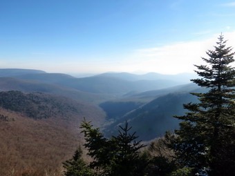
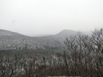
 As we started our ascent it was clear that the inch or so of snow would slow us down some. There was just enough snow to make the trail slippery but not enough to warrant the use of traction devices. Along the way there were some significant blowdowns that had been cleared. One tree was particularly large and would have required significant work to cut and clear. We walked and talked and both comment that the sky seemed overcast and almost looked like snow was on the way. There are two "bumps" before the final climb to the summit and several sets of rocks to work through. Somewhere after the first bump the snow began to come down. There were only a few flakes at first but eventually it was really snowing a more snow accumulated on the trail. I thought about the descent over the slippery rocks and roots! After the second bump and just before the final ascent, we walked along a path that lead to a lookout to the south. I took some pictures through the falling snowflakes and toward the advancing heavier snow. As we departed, I inspected the rock formation of the lookout which was quite impressive. The final ascent up the mountain is not one of my favorites. In several places the trail hugs the side of the hill and is pretty rocky. We passed the spring and the lean-to and then started up the steepest part to the flat summit. I knew this would be an interesting descent. Once on the top we walked passed the path to another lookout and continued to the spot on the trail that is the summit. It was 12:30 PM and it had taken us 2.5 hours to cover the 3.8 miles.
 On the way back down we walked off the trail to the left to go to the lookout. This viewpoint has provided me with some really nice photographic opportunities in the past. On this day the lookout rock was covered in snow and the views were mostly of the snow in the air! After a few pictures, Brad and I got a drink and ate a sandwich before attacking the descent. As soon as we were back on the main trail, Sheila began dashing up and down the trail and through the woods. Brad and I both marveled at the amount of energy she still had left! As I had expected the slippery layer of snow slowed our descent some. I had to admit that going down WAS easier than going up. The two "bumps" on the way back were not appreciated by either of us but both look a lot more imposing than they really are. Soon we were down to the bridges which we crossed without incident. The snow had stopped somewhere on our descent and there was a lot less of it on the ground at the lower elevations. By this time we both had a sense of urgency to get home as we knew we would probably be going to get A Christmas tree. The hike back on the woods road was fast. We arrived back at the car just before 3:00 PM having covered 7.6 miles and 2351 vertical feet in 4 hours and 50 minutes.
![]()
![]()
![]()
![]()
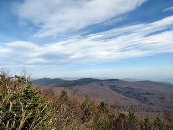
![]() On Friday, November 23rd, I wanted to hike a Catskill 3500 peak close to home. I had settled on Peekamoose and Table since they are close. I was worried about hunting in the area but had only seen a few hunters there in the past. When my son Kurt decided to stay over after Thanksgiving and said he wanted to hike the next day I was very pleased. We got Sheila in the car and left Livingston Manor a little after 9:00 AM and headed for Grahamsville. The skies were still a little cloudy but were clearing and I was hoping for some good pictures from the lookouts along the way. The temperature was in the high 30's but was supposed to warm into the low 50's during the day. We arrived in the parking area and immediately got on the trail by 9:45 AM. I must admit that Sheila seemed ready to go but that I was tired. The first part of the trail to the register box is not very steep but I had to stop several times to get my breath. I had not hiked a 35 in some time and 6 or 8 miles of flat or rolling hiking cannot compare. The trail to Peekamoose is a constant uphill punctuated by a few flatter spots in between. I began to get adjusted to the constant incline and was happy to be out with Kurt and Sheila. Sheila was running up and down the trail investigating some scents in the woods but never very far from us. The first 2.3 miles to Reconnoiter Rock has four or five steeper rock scrambles followed by flatter terrain. We arrived at the rock at about 11:20 AM and stopped to get a drink and some pictures. After a brief stay, we continued on our way.
On Friday, November 23rd, I wanted to hike a Catskill 3500 peak close to home. I had settled on Peekamoose and Table since they are close. I was worried about hunting in the area but had only seen a few hunters there in the past. When my son Kurt decided to stay over after Thanksgiving and said he wanted to hike the next day I was very pleased. We got Sheila in the car and left Livingston Manor a little after 9:00 AM and headed for Grahamsville. The skies were still a little cloudy but were clearing and I was hoping for some good pictures from the lookouts along the way. The temperature was in the high 30's but was supposed to warm into the low 50's during the day. We arrived in the parking area and immediately got on the trail by 9:45 AM. I must admit that Sheila seemed ready to go but that I was tired. The first part of the trail to the register box is not very steep but I had to stop several times to get my breath. I had not hiked a 35 in some time and 6 or 8 miles of flat or rolling hiking cannot compare. The trail to Peekamoose is a constant uphill punctuated by a few flatter spots in between. I began to get adjusted to the constant incline and was happy to be out with Kurt and Sheila. Sheila was running up and down the trail investigating some scents in the woods but never very far from us. The first 2.3 miles to Reconnoiter Rock has four or five steeper rock scrambles followed by flatter terrain. We arrived at the rock at about 11:20 AM and stopped to get a drink and some pictures. After a brief stay, we continued on our way.
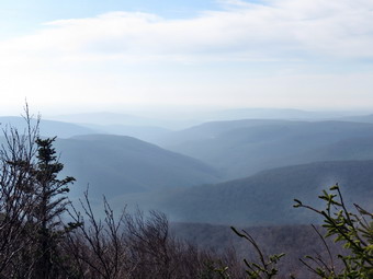 Over the next .7 miles we ascended almost 600 feet to a large flat rock that acts as a nice lookout to the south. Both Kurt and I had removed our jackets but were still sweating on the hike. When we arrived at the lookouts, the temperature was noticeably cooler perhaps since the wind had picked up. The views were variable with a haze hanging to the east but clearer views to the west. Even someone the hazy view seemed interesting. I took some pictures in all directions and at different zooms before getting out of the wind and back on the trail. The trail just after the lookouts is flat for a short distance before the final assault on the summit of Peekamoose. Both Kurt and I were tired by this time and we were pretty sure we would be skipping Table. We had gotten a later start than we had planned and were due back in Livingston Manor no later than 3:00 PM. The final climb up Peekamoose was not too difficult and soon the rock that marks the summit was in sight. He had hiked 3.7 miles in a little over 2.5 hours. We stopped at the summit and I took some pictures of Kurt and Sheila by the rock. We walked out to the illegally cut viewpoint and I took some more pictures there. I know it is not a good idea to allow people to cut lookouts wherever they want but this one does have some nice views! We turned around and started back to the car at about 12:30 PM.
 As we started back down the mountain, I was surprised that we had not encountered any other hikers especially since there were there vehicles at the parking area. As soon as we turned around, Sheila began dashing up and down the trail. Kurt and I both marveled at the amount of energy she still had left! Soon we began to hear voices and we put Sheila on her leash. We continued on down the mountain and soon realized the voices were behind us. I guess I got a little competitive and wanted to stay ahead of the approaching hikers as I increased my pace substantially. The voices fell back just as we encountered another pair of hikers coming up the trail. They mentioned they had seen two hunters dragging a bear out to the trailhead. I must admit that I enjoy eating venison but am always sad to see a bear killed. Very few people eat the meat and simply take the animal for a trophy. We talked to the hikers only briefly and continued on the trail meeting two more couples on the way up. We wondered if they knew how long it would take to get to the top and how early darkness comes to the woods! Eventually the hikers behind us caught up and we talked to them briefly. They were from Vermont but he had grown up in Red Hook and knew the mountains well. From that point on it was just a matter of hiking downhill to the car,. After turning onto the woods road that makes up the last mile or so of then trail, we were both bothered by the rolling rocks under a slippery covering of leaves. The leaves made the rocks impossible to see and the whole experience was decidedly miserable. We were back at the car at 2:20 PM having covered 7.3 miles in 4.5 hours. The pace was quicker than I thought and I regretted, if only for a moment, not tackling Table.
![]()
![]() On Monday, November 19th I was exhausted from a weekend of ambulance calls so I decided to leave hiking for Tuesday. When my son Karl appeared at the house and announced he was available to hike my plans changed. I wanted to show him my handiwork on the Quick Lake trail so we headed for Frick Pond. We arrived in the parking area around 10:45 AM and got right out on the trail. There were no cars parked which meant we would probably not encounter any hunters. It was just above 40 degrees but the breeze made it seem cooler. I had a light softshell with a hat and gloves to begin the hike. The trail from the parking area to Frick Pond was as wet as it had been a few days before and this continued for much of the hike. I don't mind hiking with other people but can so rarely find anyone to hike. Karl and I have a lot of similar interests so hiking with him is a real pleasure. I was a little surprised to find some of the snow that was prominent on Thursday still lingering in some areas. We stopped
briefly at the pond and I decided not to take pictures but to just enjoy the walk. After only
a short distance, we ran into the first of what would be over a dozen blowdowns that we cleared. It was a small one an Karl did not seem impressed. As we continued on the trail, it was a
pleasure to hike unimpeded by the trees that once blocked the way! Karl duly noted the size and the volume of what we cleared When we got to Iron Wheel Junction, we decided to do the big loop up to Hodge. We made the left turn to continue on the Quick Lake Trail and almost immediately found a tree across the trail. As we continued toward Junkyard Junction, we found at least six more areas that need to be cleared. The snowmobilers usually do a good job on this section of trail but it would be ideal to get these areas cleared
sooner than later. The trail continued to be wet and muddy in places but we were soon at the trail junction where we turned right to get on the Flynn Trail.
On Monday, November 19th I was exhausted from a weekend of ambulance calls so I decided to leave hiking for Tuesday. When my son Karl appeared at the house and announced he was available to hike my plans changed. I wanted to show him my handiwork on the Quick Lake trail so we headed for Frick Pond. We arrived in the parking area around 10:45 AM and got right out on the trail. There were no cars parked which meant we would probably not encounter any hunters. It was just above 40 degrees but the breeze made it seem cooler. I had a light softshell with a hat and gloves to begin the hike. The trail from the parking area to Frick Pond was as wet as it had been a few days before and this continued for much of the hike. I don't mind hiking with other people but can so rarely find anyone to hike. Karl and I have a lot of similar interests so hiking with him is a real pleasure. I was a little surprised to find some of the snow that was prominent on Thursday still lingering in some areas. We stopped
briefly at the pond and I decided not to take pictures but to just enjoy the walk. After only
a short distance, we ran into the first of what would be over a dozen blowdowns that we cleared. It was a small one an Karl did not seem impressed. As we continued on the trail, it was a
pleasure to hike unimpeded by the trees that once blocked the way! Karl duly noted the size and the volume of what we cleared When we got to Iron Wheel Junction, we decided to do the big loop up to Hodge. We made the left turn to continue on the Quick Lake Trail and almost immediately found a tree across the trail. As we continued toward Junkyard Junction, we found at least six more areas that need to be cleared. The snowmobilers usually do a good job on this section of trail but it would be ideal to get these areas cleared
sooner than later. The trail continued to be wet and muddy in places but we were soon at the trail junction where we turned right to get on the Flynn Trail.
 The Flynn Trail was very wet but
most of the small branches that had blocked the trail in the summer were gone. There was still some snow in
this area. As we walked along, we did find several areas that need to be cleared with a chainsaw. At the gate
we turned to go down to Hodge Pond. In this short section of trail there were two large trees blocking our
passage. Both of these will need to be removed. When we got to Hodge Pond, we decided to walk around the back of the pond on the jeep trail. We were soon at the outlet end of the pond where we turned to climb the Flynn Trail to the junction with the Big Rock Trail. I had outfitted Sheila with the training collar but did not need to use it as she behaved very well. Sheila was very intent on investigating various smells and tracks in the woods but was never very far away and came quickly when called. We were soon at the trail junction where we continued straight ahead on the Flynn Trail. This last 1.7 miles always seems long to me as there is not really much to see but having Karl along made it go much faster. There are still quite a few
trees across this part of the trail which should be cleared. Some are old and have been down for some time while others are newer. Most of the trees on this section are hardwoods which would be suitable to burn for firewood. As we approached the gate, I put Sheila on her leash and we walked around another tree that blocks the trail in this area. Further down the trail we neared the register box and found it and the outlet of the trail blocked by another huge tree. We were back at the car by 1:15 PM having covered a little over 6 miles in
2.5 hours. The progress in clearing these trails is good but more needs to be done to make the area completely
accessible.
The Flynn Trail was very wet but
most of the small branches that had blocked the trail in the summer were gone. There was still some snow in
this area. As we walked along, we did find several areas that need to be cleared with a chainsaw. At the gate
we turned to go down to Hodge Pond. In this short section of trail there were two large trees blocking our
passage. Both of these will need to be removed. When we got to Hodge Pond, we decided to walk around the back of the pond on the jeep trail. We were soon at the outlet end of the pond where we turned to climb the Flynn Trail to the junction with the Big Rock Trail. I had outfitted Sheila with the training collar but did not need to use it as she behaved very well. Sheila was very intent on investigating various smells and tracks in the woods but was never very far away and came quickly when called. We were soon at the trail junction where we continued straight ahead on the Flynn Trail. This last 1.7 miles always seems long to me as there is not really much to see but having Karl along made it go much faster. There are still quite a few
trees across this part of the trail which should be cleared. Some are old and have been down for some time while others are newer. Most of the trees on this section are hardwoods which would be suitable to burn for firewood. As we approached the gate, I put Sheila on her leash and we walked around another tree that blocks the trail in this area. Further down the trail we neared the register box and found it and the outlet of the trail blocked by another huge tree. We were back at the car by 1:15 PM having covered a little over 6 miles in
2.5 hours. The progress in clearing these trails is good but more needs to be done to make the area completely
accessible.
![]()
![]() On Thursday, November 15th I wanted to hike the Quick Lake Trail from the parking area to Iron Wheel Junction to experience the newly cleared areas for myself. On Monday I had cleared all the blowdowns after Don from Accord had cut them up with his chainsaw. Sheila and I got to the parking area around 10:45 AM and got right out on the trail. It was barely 40 degrees but I warmed quickly while hiking. The trail from the parking area to Frick Pond was wet which, I found, was a harbinger of things to come. I was a little surprised to find a dusting of snow all along the trail as we hiked. We stopped at the pond and I took a few pictures before continuing over then bridge and up the Quick Lake Trail. After only a short distance, we ran into the first of what would be over a dozen blowdowns that we cleared. It was a pleasure to hike unimpeded along the trail! I stopped to take a few pictures of the open trail, and the piles of wood and brush I had made along the way. When we got to Iron Wheel Junction, I decided to do the big loop up to Hodge despite a nagging pain behind my left knee. At track practice on Wednesday I decided to "sprint" a 200 without warming up. After about 100 meters, I felt a twinge in my lower hamstring. I was lucky it wasn't worse! We made the left turn to continue on the Quick Lake Trail and almost immediately found a tree across the trail. As we continued toward Junkyard Junction, we found at least six more areas that need to be cleared. The snowmobilers usually do a good job on this section of trail but it would be ideal to get these areas cleared sooner than later. The trail continued to be wet and muddy in places but we were soon at the trail junction where we turned right to get on the Flynn Trail.
On Thursday, November 15th I wanted to hike the Quick Lake Trail from the parking area to Iron Wheel Junction to experience the newly cleared areas for myself. On Monday I had cleared all the blowdowns after Don from Accord had cut them up with his chainsaw. Sheila and I got to the parking area around 10:45 AM and got right out on the trail. It was barely 40 degrees but I warmed quickly while hiking. The trail from the parking area to Frick Pond was wet which, I found, was a harbinger of things to come. I was a little surprised to find a dusting of snow all along the trail as we hiked. We stopped at the pond and I took a few pictures before continuing over then bridge and up the Quick Lake Trail. After only a short distance, we ran into the first of what would be over a dozen blowdowns that we cleared. It was a pleasure to hike unimpeded along the trail! I stopped to take a few pictures of the open trail, and the piles of wood and brush I had made along the way. When we got to Iron Wheel Junction, I decided to do the big loop up to Hodge despite a nagging pain behind my left knee. At track practice on Wednesday I decided to "sprint" a 200 without warming up. After about 100 meters, I felt a twinge in my lower hamstring. I was lucky it wasn't worse! We made the left turn to continue on the Quick Lake Trail and almost immediately found a tree across the trail. As we continued toward Junkyard Junction, we found at least six more areas that need to be cleared. The snowmobilers usually do a good job on this section of trail but it would be ideal to get these areas cleared sooner than later. The trail continued to be wet and muddy in places but we were soon at the trail junction where we turned right to get on the Flynn Trail.
The Flynn Trail was very wet but most of the small branches that had blocked the trail in the summer were gone. There was a lot more snow in this area. As we walked along, we did find several areas that need to be cleared with a chainsaw. At the gate we turned to go down to Hodge Pond. In this short section of trail there were two large trees blocking our passage. Both of these will need to be removed. When we got to Hodge Pond, I decided to stay on the Flynn Trail and go around the front of the pond. This section had no blowdown and we were soon in the field at the outlet end of the pond. We stopped and I took a few pictures before we turned to walk out the Flynn Trail to the car. As we walked up toward the junction with the Big Rock Trail there were hundreds of turkey footprint on the ground. Sheila was very intent on investigating these and was only distracted by a partridge that took off up the trail. We were soon at the trail junction where we continued straight ahead on the Flynn Trail. This last 1.7 miles always seems long to be as there is not really much to see. There are still quite a few trees across this part of the trail which should be cleared. Some are old and have been down for some time while others are newer. Most of the trees on this section are hardwoods which would be suitable to burn for firewood. As we approached the gate, I put Sheila on her leash and we walked around another tree that blocks the trail in this area. Further down the trail we neared the register box and found it and the outlet of the trail blocked by another huge tree. We were back at the car by 1:45 PM having covered a little over 6 miles in 2.5 hours. The progress in clearing these trails is good but more needs to be done to make the area completely accessible.
On Monday, November 12th I was still a little tired from the 7.5 mile quick march around Bear Spring the day before. Around 10:30 AM Lisa from Morgan Outdoors, the local hiking store, called me to ask what I was doing. She explained that a DEC employee had received permission to use a chainsaw to remove the large trees that were blocking the Quick Lake Trail from Frick Pond to Iron Wheel Junction. She asked if I would go to help remove the trees after Don from Accord had used the chainsaw to cut them up. I agreed as I had some free time and had been very vocal about getting this trail cleared. I did not plan on taking Sheila but could not resist "the look". Sheila and I arrived at about 11:15 and started to hike out to Frick Pond. I did not hear a chainsaw and did not see anything cut and began to wonder if I had understood Lisa correctly! After crossing the outlet bridge at the pond, we headed up the Quick Lake Trail. I saw two trees cut up on the trail and then heard the chainsaw. After clearing the small trees, we continued on the trail but found several large blowdowns still intact. A little farther on we ran into Don who explained he had started by walking out to Iron Wheel Junction and then working his way back. We talked for a while and I found he also was a hiker. We were both wanted to finish our jobs on this day so I took Sheila and headed the other way toward Iron Wheel to keep her out of Don's way.
I immediately ran into a large hemlock Don had cut up. I didn't blame him that he hadn't taken the time to limb it but that made my job more challenging. After clearing that tree, we headed up the trail removing anything that blocked it. We were soon at the brook across the trail where I cleared another tree and then continued across toward the junction. There were several more large trees, some branches and limbs and brush to clear along the way. I tried to pile the wood as some was cherry and maple. I also attempted to pile the brush off the trail as aesthetically as possible. I was getting tired as we approached Iron Wheel Junction but there was only some brush and a few branches on the last part. We turned around and started back toward Frick Pond. I knew that some of the largest trees and biggest snags awaited me. Sheila was very well-behaved. She ran back and forth on the trail occasionally removing branch and at other times depositing them. At one point she appeared bored and took a short nap by my pack. The first tree we encountered back near the pond was the largest hemlock. I actually walked around it and cleared another tree before tackling this most difficult one. It took some time but soon I had the entire tree dragged off the trail. The remaining trees had large diameters and Don had cut them into longer lengths. A few were large enough that I found them hard to flip or roll! By 3:00 PM I had cleared the last tree with the largest piece and we hiked back to the car. We were back at 3:30 PM having spent 4 hours doing some of the hardest work I have done in a long time. The "reward" was looking up the trail to see no blockages. I look forward to hiking this in the near future just to enjoy my handiwork. The next spot that needs work is the Flynn Trail from Junkyard Junction to Hodge Pond.
![]() On Sunday, November 11th Cindy and I wanted to take a hike
after church. I wasn't finished preaching in Roscoe until 12:15 PM so we knew it would be a late start. We
decided to go to Bear Spring since the trails are wide and open. Also, Bear Spring doesn't have too many hills
which made Cindy happy. We got our gear and put Sheila in the car and were ready to go. Sheila had not been out
for a week so she was more than happy to be going on a hike. We drove through Roscoe and Downsville heading
toward Walton. Near the top of the hill I parked in the wide area on the west side of the road at about 1:45 PM.
We were ready to go almost immediately and walked up through the woods to the wide trail known as Wilson Hollow
Road. As we started our walk along the road, we immediately were confronted by one of the many clear cut
areas at Bear Spring. I usually take pictures here but the day was overcast with a haze hanging over the
countryside and the sun stating to get low in the sky. Since the conditions were not conducive to photography
and it was getting late, I decide to forgo the pictures for the day. Sheila was delighted to be out as was
running ahead of us and then turning around to run back passed us again and again. At one point she stopped and
stared intently ahead. She sometimes does this when she sees a leaf or stick move but this time I saw some
people ahead on the trail. I put a leash on Sheila as we approached. I expected to find hunters scouting the
area for the beginning of deer season but instead found a father pushing one son along in a stroller with
the other one walking beside. We said "hello" and commented on the beautiful weather before going our separate
ways. The trail rolls some but has no major climbs. At 1.25 miles we passed the trail that leads down to Launt
Pond on East Trout Brook Road. Around 1.9 miles we came to another road that also heads down the hill to the
road. Finally, at 2.2 miles we were at a point where we could make a decision on which way we wanted to go to
make the loop of our lollipop hike. I decided to go straight ahead rather than to turn right into the field. It
was 2:30 PM so it had taken us about 45 minutes to hike over 2 miles.
On Sunday, November 11th Cindy and I wanted to take a hike
after church. I wasn't finished preaching in Roscoe until 12:15 PM so we knew it would be a late start. We
decided to go to Bear Spring since the trails are wide and open. Also, Bear Spring doesn't have too many hills
which made Cindy happy. We got our gear and put Sheila in the car and were ready to go. Sheila had not been out
for a week so she was more than happy to be going on a hike. We drove through Roscoe and Downsville heading
toward Walton. Near the top of the hill I parked in the wide area on the west side of the road at about 1:45 PM.
We were ready to go almost immediately and walked up through the woods to the wide trail known as Wilson Hollow
Road. As we started our walk along the road, we immediately were confronted by one of the many clear cut
areas at Bear Spring. I usually take pictures here but the day was overcast with a haze hanging over the
countryside and the sun stating to get low in the sky. Since the conditions were not conducive to photography
and it was getting late, I decide to forgo the pictures for the day. Sheila was delighted to be out as was
running ahead of us and then turning around to run back passed us again and again. At one point she stopped and
stared intently ahead. She sometimes does this when she sees a leaf or stick move but this time I saw some
people ahead on the trail. I put a leash on Sheila as we approached. I expected to find hunters scouting the
area for the beginning of deer season but instead found a father pushing one son along in a stroller with
the other one walking beside. We said "hello" and commented on the beautiful weather before going our separate
ways. The trail rolls some but has no major climbs. At 1.25 miles we passed the trail that leads down to Launt
Pond on East Trout Brook Road. Around 1.9 miles we came to another road that also heads down the hill to the
road. Finally, at 2.2 miles we were at a point where we could make a decision on which way we wanted to go to
make the loop of our lollipop hike. I decided to go straight ahead rather than to turn right into the field. It
was 2:30 PM so it had taken us about 45 minutes to hike over 2 miles.
For the next 1.3 miles the trail has a few ups and downs as it continues southeast before making a sharp turn to head almost due west. At this point it also begins to drop and loses 450 feet in the next mile. The downhill felt good and we made good time but we knew what was waiting at the up ahead. At the next trail junction we continued around the hill to complete the loop. It was 3:30 PM when we arrived at the lowest point on the hike and turned right toward the north to finish the loop. It was 3:30 PM and the sun was beginning to drop below the farthest ridge. Once we made the turn one of the few long hills at Bear Spring confronted us! Over the next .8 miles we regained the 450 feet we had lost. The gradient was not steep but we were trying to hurry and it came at the end of the hike! By 3:50 PM we were back at Wilson Hollow Road where we made a left to head northwest and back to the parking area. We covered the next 1.9 miles in about 45 minutes which was the same as the trip out! By 4:35 PM we were back at the car having covered 7.5 miles in just over 2 hours and 45 minutes.
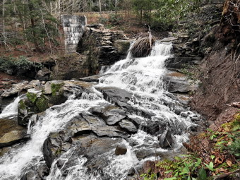
![]() On Sunday, November 4th Cindy and I walked up the hill behind the Catholic Church in Livingston Manor to get some views from the cleared area at the top. After this we headed to a private tract of land on Shandelee where my son Karl and I had hiked the day before. When I called the caretaker to thank him, he mentioned a waterfalls on Cattail Creek. He made it sound so nice that I had to try to find it. We parked started to walk up the ridge. This time we took the "low road", turning right before reaching the top of the ridge. There were a few viewpoints along the way and a LOT of blowdown across the woods road. After a short walk we came to another rock quarry cut into the side of the hill. I looked for drill holes but did not find any. A road led uphill from the quarry and there seemed to be a cleared area at the top. We walked up the hill and found ourselves at the same viewpoint Karl and I had found the day before. We walked to the fire circle. We both took some pictures before heading down to the quarry to continue our hike. The surroundings began to become familiar especially when we passed the same house from the day before. This time we stayed low heading south and southeast until we could see Cattail Creek below. We turned northeast to follow the reek and cross the power lines.
On Sunday, November 4th Cindy and I walked up the hill behind the Catholic Church in Livingston Manor to get some views from the cleared area at the top. After this we headed to a private tract of land on Shandelee where my son Karl and I had hiked the day before. When I called the caretaker to thank him, he mentioned a waterfalls on Cattail Creek. He made it sound so nice that I had to try to find it. We parked started to walk up the ridge. This time we took the "low road", turning right before reaching the top of the ridge. There were a few viewpoints along the way and a LOT of blowdown across the woods road. After a short walk we came to another rock quarry cut into the side of the hill. I looked for drill holes but did not find any. A road led uphill from the quarry and there seemed to be a cleared area at the top. We walked up the hill and found ourselves at the same viewpoint Karl and I had found the day before. We walked to the fire circle. We both took some pictures before heading down to the quarry to continue our hike. The surroundings began to become familiar especially when we passed the same house from the day before. This time we stayed low heading south and southeast until we could see Cattail Creek below. We turned northeast to follow the reek and cross the power lines.
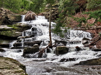 Just passed the power lines a small sign announced "Falls Trail". It was unclear where the trail led but I headed along a ridge perpendicular to the stream. I descend a short but steep bank to the edge of the stream. The falls were very nice with a good volume. I took some pictures from different angles. I soon realized that Cindy had not followed me and Sheila was no where to be found. I headed back up the bank to the main trail where they were waiting. We walked parallel to the creek until the falls came into view. The problem was that the falls were shielded by some pine trees that made getting a clear shot almost impossible. After taking a few pictures, we walked won to the stream an got some better views. It was clear that we would have to cross the stream to get the best view. Fortunately, there were some rather dry rocks placed close together which made crossing possible. The view from the other side was spectacular. We both took many pictures from different angles and distances. The most striking thing was that we were both unaware that the falls were there even though we had passed by them hundreds of times. Near the top I could see the remains of an old dam. At that point, I knew that these were the falls that had been dammed to provide electricity for Livingston Manor. Enough power was generated to supply a few houses with power for about four hours each day. We walked up the steep bank to Shandelee Road and then back to the car. We covered 2.4 miles in 1.5 hours but had a lot of fun "discovering" these falls.
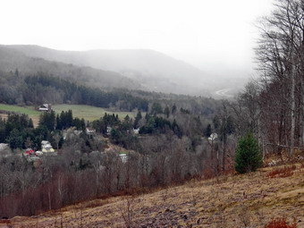
![]() On Sunday, November 4th my wife Cindy and I decided to take a hike after church. Our first objective was to visit an area of land cleared on a hill behind the Catholic Church in Livingston Manor. I had permission from the caretaker so we parked at the start of the access road and hiked up that road to the top. The temperature was barely 40 degrees and snowflakes were in the air. I know that many people hike and ride mountain bikes here and some do so without permission. The land at the top was cleared and the access road built so that a casino could be placed on top of the hill. The project was never completed. On our way up the hill we passed several areas where red shale had been taken from the side of the hill. On the way up I stopped to take some pictures facing back toward Upper Main Street. Once at the cleared area on the top we walked to a viewpoint toward Round Top and the Livingston Manor "Flats". The day was completely overcast and I couldn't help but think how much more beautiful the views would be on a with some sun and clouds. I walked over to the other side of the field to take some more pictures toward town. As I shot the pictures, I could see a snow squall headed into town and then up the hill toward us. We retreated into the woods at the top to walk around a little. Cindy headed down the way we had come up and I went in the other direction. We met at the bottom of the steepest part of the hill. The place where we met was obviously an old rock quarry. We walked back down to the car to drive to our next adventure. We had spent about 50 minutes on our 1.6 mile jaunt.
On Sunday, November 4th my wife Cindy and I decided to take a hike after church. Our first objective was to visit an area of land cleared on a hill behind the Catholic Church in Livingston Manor. I had permission from the caretaker so we parked at the start of the access road and hiked up that road to the top. The temperature was barely 40 degrees and snowflakes were in the air. I know that many people hike and ride mountain bikes here and some do so without permission. The land at the top was cleared and the access road built so that a casino could be placed on top of the hill. The project was never completed. On our way up the hill we passed several areas where red shale had been taken from the side of the hill. On the way up I stopped to take some pictures facing back toward Upper Main Street. Once at the cleared area on the top we walked to a viewpoint toward Round Top and the Livingston Manor "Flats". The day was completely overcast and I couldn't help but think how much more beautiful the views would be on a with some sun and clouds. I walked over to the other side of the field to take some more pictures toward town. As I shot the pictures, I could see a snow squall headed into town and then up the hill toward us. We retreated into the woods at the top to walk around a little. Cindy headed down the way we had come up and I went in the other direction. We met at the bottom of the steepest part of the hill. The place where we met was obviously an old rock quarry. We walked back down to the car to drive to our next adventure. We had spent about 50 minutes on our 1.6 mile jaunt.
![]() On Saturday, November 3rd my son Karl agreed to go on a local hike. I was lucky enough to obtain permission to hike on a private tract of over 600 acres on nearby Shandelee. The caretaker described several areas with nice views and I was anxious to hike the area before it is sold. We took our two dogs, Sheila and Maggie, with us and headed up the mountain parking at about 10:40 AM. The area is crisscrossed by numerous woods roads and the trick is to pick the right ones. Our objective was to hike back toward Livingston Manor to a viewpoint overlooking the town. The first mile had the most serious ascent gaining 450 feet with some places much steeper than others. We had a general idea that we wanted to head northeast but we were also looking for viewpoints. Around 11:20 AM we walked out into a open field that had excellent views to the east and southeast. The land had been cleared and many large boulders moved top form a large fire circle. To the east the skies were overcast with a uniform gray cast. The skies to the southeast were blue with large puffy clouds. I took a number of shots before we decided to take the high road heading northeast. We worked our way northeast always choosing the road that headed in that direction at any intersection. Just before noon we crossed the Marcy South right-of-way with its massive towers and high voltage transmission lines. As we continued, we passed by a house and then an area with at least two "pads" with what looked like electricity and water. We continued along the roads until about 12:10 PM. At this point we had hiked 2.9 miles and were in a field overlooking Livingston Manor. I took some pictures but a good part of the town was blocked by trees.
On Saturday, November 3rd my son Karl agreed to go on a local hike. I was lucky enough to obtain permission to hike on a private tract of over 600 acres on nearby Shandelee. The caretaker described several areas with nice views and I was anxious to hike the area before it is sold. We took our two dogs, Sheila and Maggie, with us and headed up the mountain parking at about 10:40 AM. The area is crisscrossed by numerous woods roads and the trick is to pick the right ones. Our objective was to hike back toward Livingston Manor to a viewpoint overlooking the town. The first mile had the most serious ascent gaining 450 feet with some places much steeper than others. We had a general idea that we wanted to head northeast but we were also looking for viewpoints. Around 11:20 AM we walked out into a open field that had excellent views to the east and southeast. The land had been cleared and many large boulders moved top form a large fire circle. To the east the skies were overcast with a uniform gray cast. The skies to the southeast were blue with large puffy clouds. I took a number of shots before we decided to take the high road heading northeast. We worked our way northeast always choosing the road that headed in that direction at any intersection. Just before noon we crossed the Marcy South right-of-way with its massive towers and high voltage transmission lines. As we continued, we passed by a house and then an area with at least two "pads" with what looked like electricity and water. We continued along the roads until about 12:10 PM. At this point we had hiked 2.9 miles and were in a field overlooking Livingston Manor. I took some pictures but a good part of the town was blocked by trees.
 From the field we continued northeast to see if we could find a route that formed a loop. We passed through another large field which had been mowed. At the base of the field we caught another road and headed back to the power lines a little north of our previous crossing. We walked up the right-of-way and then found a road leading west. After a short distance on this road, we caught sight of a house and turned around not wanting to trespass on private land. We walked back up the right-of-way to the spot where we had crossed before and headed back. At some point we turned a little northwest and then southwest to vary the route. We didn't find anything to remarkable but the variation was nice. Eventually we worked our way back to the path we had taken up to the ridge earlier. We followed our original route back to the car arriving at 1:35 PM having covered 6 miles in just under 3 hours.
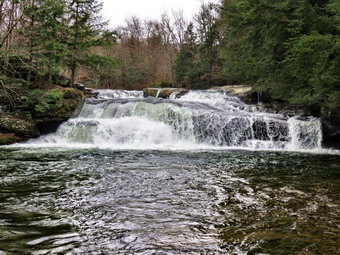
![]() On Friday, November 2nd I decided to return to Beaverkill Falls to take some more pictures. When I returned home on Thursday and began processing pictures, I realized that I had several errant settings on my camera. I drove up the road to Quill Gordon and parked just passed the lodge. I walked to the path down the bank and through the gate to the stream bed. The day was very overcast with a gray sky. The lack of blue sky and clouds was offset by better lighting. The rocks were not as slippery as the day before but I was careful to keep a solid footing. I took many pictures of the falls just upstream from my position and more pictures downstream. I tried some different angles and the rocks were dry enough to let me walk up the near bank for some closer shots. I even filmed a high definition video which was a first with the new camera. I walked back to the car and drove to South Beaverkill Falls Road where I parked for my second approach to the falls. A woods road led to the base of the falls on the other side. I shot some more pictures from this side using different angles and levels. It was possible to walk out on the rocks so that I could face the falls almost head on. I also took some more photographs downstream. When I got home I looked at the pictures and most were a great improvement over the day before. The video showed the power of the stream visually and aurally.
On Friday, November 2nd I decided to return to Beaverkill Falls to take some more pictures. When I returned home on Thursday and began processing pictures, I realized that I had several errant settings on my camera. I drove up the road to Quill Gordon and parked just passed the lodge. I walked to the path down the bank and through the gate to the stream bed. The day was very overcast with a gray sky. The lack of blue sky and clouds was offset by better lighting. The rocks were not as slippery as the day before but I was careful to keep a solid footing. I took many pictures of the falls just upstream from my position and more pictures downstream. I tried some different angles and the rocks were dry enough to let me walk up the near bank for some closer shots. I even filmed a high definition video which was a first with the new camera. I walked back to the car and drove to South Beaverkill Falls Road where I parked for my second approach to the falls. A woods road led to the base of the falls on the other side. I shot some more pictures from this side using different angles and levels. It was possible to walk out on the rocks so that I could face the falls almost head on. I also took some more photographs downstream. When I got home I looked at the pictures and most were a great improvement over the day before. The video showed the power of the stream visually and aurally.
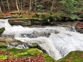
![]() On Thursday, November 1st my son Kurt and I visited Beaverkill Falls and then headed for Tompkins falls on Barkaboom Road. After hiking back to the car, I drove back to Turnwood and turned right on Barkaboom Road. I drove toward the Pepacton Reservoir and stopped at Tompkins Falls near the end of the road. The falls were flowing nicely and we walked downstream on the road so that I could take some pictures. I have walked down to the stream bed in the past but this requires a descent of a steep bank and a walk along a narrow concrete shelf. On this day I was happy to take pictures from the bank using the zoom. Back at the car I walked down to the top of the falls and took more pictures. Some of the views here were very nice and the water volume was high. Some foundations and rock work were visible on the other side. Tompkins Falls was once dammed and was used to provide electrical power to Shavertown, Pepacton and Arena. These towns were flooded when the Pepacton Reservoir was created. After I finished taking, we returned to the car for the ride home.
On Thursday, November 1st my son Kurt and I visited Beaverkill Falls and then headed for Tompkins falls on Barkaboom Road. After hiking back to the car, I drove back to Turnwood and turned right on Barkaboom Road. I drove toward the Pepacton Reservoir and stopped at Tompkins Falls near the end of the road. The falls were flowing nicely and we walked downstream on the road so that I could take some pictures. I have walked down to the stream bed in the past but this requires a descent of a steep bank and a walk along a narrow concrete shelf. On this day I was happy to take pictures from the bank using the zoom. Back at the car I walked down to the top of the falls and took more pictures. Some of the views here were very nice and the water volume was high. Some foundations and rock work were visible on the other side. Tompkins Falls was once dammed and was used to provide electrical power to Shavertown, Pepacton and Arena. These towns were flooded when the Pepacton Reservoir was created. After I finished taking, we returned to the car for the ride home.
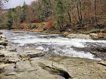
![]() On Thursday, November 1st I decided to go to some local waterfalls to take some pictures. I thought that the recent rain would have swelled the creeks some and made the falls interesting. My son Kurt and I got in the car with my dog Sheila and headed for the Beaverkill Valley. I had wanted to stop and photograph the Beaverkill Falls near Quill Gordon Lodge but the falls are on private property. To get permission I stopped at the office in Lew Beach and asked for permission. I was told that they could not give me permission but that we should be careful! We drove up the road to Quill Gordon and parked just passed the lodge. We walked to the path down the bank and through the gate to the stream bed. The day was very overcast with a gray sky. The lack of blue sky and clouds was offset by better lighting. The rocks were very slippery so I was careful to keep a solid footing. I took many pictures of the falls just upstream from our position and more pictures downstream. We walked back to the car and drove to South Beaverkill Falls Road where we parked for our second approach to the falls. A woods road led to the base of the falls on the other side. I shot some more pictures from this side using different angles and levels. It was possible to walk out on the rocks so that I could face the falls almost head on. I also took some more photographs downstream. Back at the car we headed back to Barkaboom Road to go to Tompkins Falls.
On Thursday, November 1st I decided to go to some local waterfalls to take some pictures. I thought that the recent rain would have swelled the creeks some and made the falls interesting. My son Kurt and I got in the car with my dog Sheila and headed for the Beaverkill Valley. I had wanted to stop and photograph the Beaverkill Falls near Quill Gordon Lodge but the falls are on private property. To get permission I stopped at the office in Lew Beach and asked for permission. I was told that they could not give me permission but that we should be careful! We drove up the road to Quill Gordon and parked just passed the lodge. We walked to the path down the bank and through the gate to the stream bed. The day was very overcast with a gray sky. The lack of blue sky and clouds was offset by better lighting. The rocks were very slippery so I was careful to keep a solid footing. I took many pictures of the falls just upstream from our position and more pictures downstream. We walked back to the car and drove to South Beaverkill Falls Road where we parked for our second approach to the falls. A woods road led to the base of the falls on the other side. I shot some more pictures from this side using different angles and levels. It was possible to walk out on the rocks so that I could face the falls almost head on. I also took some more photographs downstream. Back at the car we headed back to Barkaboom Road to go to Tompkins Falls.
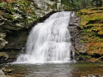
![]()
![]() On Thursday, October 25th I was ready to get out and hike again after the weather had been very uncooperative. I decided that the recent rainfall over several days might have increased the flow in the local streams and made some waterfalls more interesting. I put Sheila in the car and we headed for Trout Pond to take a look at Russell Brook Falls. I parked in the upper parking area on Morton Hill Road at about 9:15 AM and we were walking down Russell Brook Road 5 minutes later. As we approached the first camping area, I could here the stream below roaring. We walked down to the viewpoint above the upper falls and I dropped my pack to take some pictures. The falls was flowing nicely but the day was cloudy and overcast with a lot of low-lying fog. The low light and lack of fog at the falls were ideal for photographing the falls. I took some pictures, played with the camera settings and took some more. When I we done, we headed back up to the road and walked to the lower parking area where we found no cars. I followed Sheila down the trail toward the falls. After we crossed the bridge, we turned right on the path to the falls. I was careful to watch my foot placement as the rocks were slippery and the ground saturated with water. We walked down to the stream bed and were rewarded with a nice view of the lower falls. The water was high but the flow was clear. I again experimented with different setting trying to get the soft, flowing effect by increasing the exposure time while holding the camera still. I know I need a tripod for some of these shots but have resisted carrying extra photography equipment. When I was finished, we retraced our steps out to the main trail and headed straight up to Trout Pond at the trail junction.
On Thursday, October 25th I was ready to get out and hike again after the weather had been very uncooperative. I decided that the recent rainfall over several days might have increased the flow in the local streams and made some waterfalls more interesting. I put Sheila in the car and we headed for Trout Pond to take a look at Russell Brook Falls. I parked in the upper parking area on Morton Hill Road at about 9:15 AM and we were walking down Russell Brook Road 5 minutes later. As we approached the first camping area, I could here the stream below roaring. We walked down to the viewpoint above the upper falls and I dropped my pack to take some pictures. The falls was flowing nicely but the day was cloudy and overcast with a lot of low-lying fog. The low light and lack of fog at the falls were ideal for photographing the falls. I took some pictures, played with the camera settings and took some more. When I we done, we headed back up to the road and walked to the lower parking area where we found no cars. I followed Sheila down the trail toward the falls. After we crossed the bridge, we turned right on the path to the falls. I was careful to watch my foot placement as the rocks were slippery and the ground saturated with water. We walked down to the stream bed and were rewarded with a nice view of the lower falls. The water was high but the flow was clear. I again experimented with different setting trying to get the soft, flowing effect by increasing the exposure time while holding the camera still. I know I need a tripod for some of these shots but have resisted carrying extra photography equipment. When I was finished, we retraced our steps out to the main trail and headed straight up to Trout Pond at the trail junction.
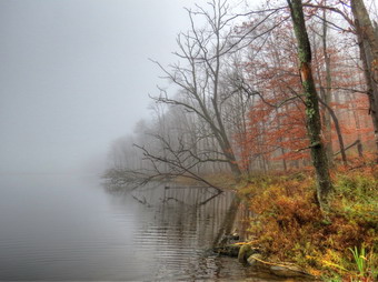 The skies continued to be overcast and when we arrived at the pond I found a dense fog obscuring all but the area closest to us. I decided to take some pictures anyway and used the bracketed exposure setting to take some shots for HDR. After the photo shoot, we continued on around the pond toward the inlet. The trail was very wet with several large puddles and a couple of small ponds. Sheila was having a great time running through the water and mud. She also had to investigate every beaver slide along the way. The beavers appeared to have been active as there were many slides along the way and each showed gnawed trees at one end and branches in the water at the other. We walked across the bridge at the inlet and I decided not to try to get to the shore for more pictures. It was 11:10 AM and we had covered the 2.2 mile distance in about 40 minutes. The trip up the shoulder of Cherry Ridge and back down the other side was uneventful. The trail was very wet and I took care not to slip on the rocks or walk through deep mud. In several places there was standing water and in many spots the trail had turned into a small stream. When we hit the junction with the snowmobile trail near Mud Pond, we turned left to head back. This part of the trail was also very wet and muddy. especially on the descent. By 12:!0 PM we had hiked 5 miles and were back at the area of the falls. We walked up the road and were back at the car by 12:25 PM having covered the 5.6 mile hike in 2 hours and 20 minutes.
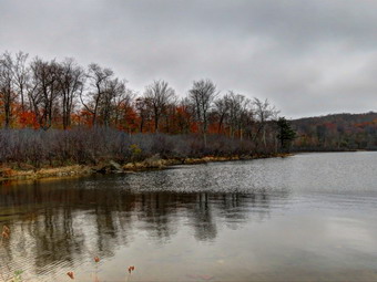
![]()
![]() On Thursday, October 18th I wanted to get in a hike close to home before cross country practice. I went to Ricketts Glen on Sunday but did not take Sheila so she was more than ready to go. I chose to go to Hodge and Frick Ponds since the area is close and I wanted to see if there were any colorful fall leaves left. As I drove up Fish Hatchery Road toward the parking area, I did see some nice colors and there were quite a few leaves on the trees. I knew that these trees were more protected and out of the wind than the ones along the trails. Sheila and I arrived at the parking area and were hiking by 10:35 AM. Sheila is doing very well without here training collar and came back every time I called her. For a little change, I decided to hike up the Flynn Trail to Hodge Pond first. The weather forecast was for partly sunny skies and highs in the low 60's but it was overcast when we arrived. As we headed up the Flynn Trail there was water in the ditches and the grass was damp. When we arrived at the path to the open field off the Flynn Trail, I decided to keep going as the sky was even darker and there was a light mist in the air. Despite the long uphill walk, we arrived at the trail junction with the Big Rock Trail at 11:10 AM after hiking 1.7 miles. We continued straight ahead to walk down the hill to Hodge Pond. We arrived at the pond at 11:25 AM and I took my pack off to take some pictures. The skies were gray and getting darker. The leaf color was muted but definitely there in places. I took some shots including a few so that I could experiment with HDR. Sheila waded a little but didn't seem to feel like swimming. We headed around the back of the pond and continued on the Flynn Trail toward Junkyard Junction.
On Thursday, October 18th I wanted to get in a hike close to home before cross country practice. I went to Ricketts Glen on Sunday but did not take Sheila so she was more than ready to go. I chose to go to Hodge and Frick Ponds since the area is close and I wanted to see if there were any colorful fall leaves left. As I drove up Fish Hatchery Road toward the parking area, I did see some nice colors and there were quite a few leaves on the trees. I knew that these trees were more protected and out of the wind than the ones along the trails. Sheila and I arrived at the parking area and were hiking by 10:35 AM. Sheila is doing very well without here training collar and came back every time I called her. For a little change, I decided to hike up the Flynn Trail to Hodge Pond first. The weather forecast was for partly sunny skies and highs in the low 60's but it was overcast when we arrived. As we headed up the Flynn Trail there was water in the ditches and the grass was damp. When we arrived at the path to the open field off the Flynn Trail, I decided to keep going as the sky was even darker and there was a light mist in the air. Despite the long uphill walk, we arrived at the trail junction with the Big Rock Trail at 11:10 AM after hiking 1.7 miles. We continued straight ahead to walk down the hill to Hodge Pond. We arrived at the pond at 11:25 AM and I took my pack off to take some pictures. The skies were gray and getting darker. The leaf color was muted but definitely there in places. I took some shots including a few so that I could experiment with HDR. Sheila waded a little but didn't seem to feel like swimming. We headed around the back of the pond and continued on the Flynn Trail toward Junkyard Junction.
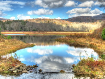 Once we passed the gate the Flynn Trail became flat and we ran into a lot of mud and standing water. I have been wearing the Keen Glarus shoes lately and are very pleased with them. They seem to be completely waterproof and are very comfortable. These shoes are wide in the toe box and allow the hiker to wear a variety of socks. This end of the Flynn Trail is starting to get grown over and has not been cleared. By 11:50 AM we had hike 3.6 miles and were at Junkyard Junction where we turned left to get on the Quick Lake Trail. The first part of the trail down to Iron Wheel Junction is also a snowmobile trail so it is well-maintained and cut back. There were a few wet areas and some places had some running water and showed erosion. At Iron Wheel Junction we turned right to stay on the Quick Lake Trail. The snowmobile trail continues straight ahead on the Logger's Loop so this part of the Quick Lake Trail is overgrown and has not had any attention in some time. In places the trail was very muddy while in others there was some erosion and running water. I stopped in a few places to take some pictures of trees which had some nice color. As we worked our way toward Frick Pond the sun began to come out and the day brightened considerably. Just after the junction with the trail around the pond, we met a family group out for a hike. We talked for a while and it seemed a few people would continue around on the Logger's Loop while the rest would just walk around the pond and back to the car. Sheila and I headed for the outlet end of Frick Pond passing through a few more muddy areas.
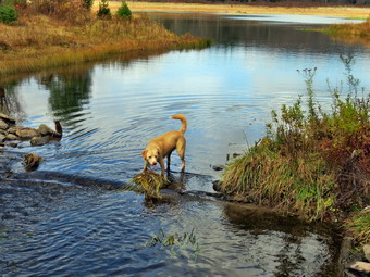 Once we got to the bridge, I took off my pack to get some pictures. Some trees still sported fall colors and the lighting was interesting. While I experimented with my camera, Sheila decided it was time to get immersed. She dove into the water and ran around. I threw a stick into deeper water and she had no trouble swimming to retrieve it. I took some pictures of Sheila but it was not easy as she was dashing around very quickly. I found that my camera will bracket photos at several different exposures. This allows me to use high dynamic range (HDR) software to combine these shots into one composite picture. After we finished at the pond, we started back to the car. Along the trail, we stopped one more time so that I could take some more pictures. We were back at the car at 1:00 PM having hiked 6.7 miles in under 2.5 hours. This was an average speed of over 3 miles per hour! I had considered stopping at Mongaup Falls but decided it was getting late and I could wait for another day.
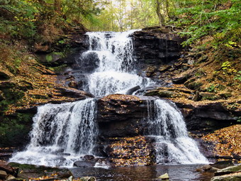
![]()
![]() On Sunday, October 14th I decided to again look for some fall colors somewhere. The leaves in the Catskills were best before Columbus Day weekend and many had fallen in the wind and the rain before and after. I knew that I would have to go south to New Jersey or Pennsylvania and decided on Pennsylvania. Ricketts Glen is one of my favorite hiking spots in the northeast outside of New York so I decided to go there. The park, or rather the Glens Natural Area, is a National Natural Landmark with 22 named falls along a 7.3 mile loop trail. The falls vary in height from 11 feet to 94 feet and each has a different character. The weather report was for partly cloudy or partly sunny skies with temperatures in the low 60's. I wanted to arrived after the morning haze had cleared but before the sun was too high in the sky. Photographing the waterfalls in the glens can be tricky as too much sun makes the water too bright and not enough leaves the images too dark. The other drawback is that the area is so popular that there are usually a lot of people and many have elaborate photographic equipment. The latter seem to have no problem setting up right in front of a waterfall and often take a very long time to get their shot! I decided not to take Sheila because of the number of people. I left Livingston Manor just before 8:00 AM and headed over the back roads toward Honesdale. The entire trip takes between 2.5 and 3 hours. The drive went pretty quickly and began to look more familiar as I got nearer. I avoided any wrong turns and arrived in the parking lot at 10:15 AM. There were already quiet a few cars in the lot and there are three or four main parking areas to choose from! I was on the trail by 10:30 AM. The first 1.4 miles of the trail to Murray Reynolds Falls rolls a little but is almost flat. In general the trails were in good shape but there always seem to be some muddy spots and places where water flows over the trail. The traffic is so high that the rocks are worn smooth and can be very slippery even when dry. When the rocks are wet, muddy and have fallen leaves on them, they become a recipe for disaster unless hikers are careful. Signs worn about proper footwear and respect for the difficulty of the trail. As I hiked I began to meet more and more people. Many hikers had on cheap sneakers with little or no tread. Many hikers had small children with them. The children seemed to be well-supervised but I couldn't help but think that just a moment of inattention could be tragic. As I suspected, many people had tripods and very expensive cameras.
On Sunday, October 14th I decided to again look for some fall colors somewhere. The leaves in the Catskills were best before Columbus Day weekend and many had fallen in the wind and the rain before and after. I knew that I would have to go south to New Jersey or Pennsylvania and decided on Pennsylvania. Ricketts Glen is one of my favorite hiking spots in the northeast outside of New York so I decided to go there. The park, or rather the Glens Natural Area, is a National Natural Landmark with 22 named falls along a 7.3 mile loop trail. The falls vary in height from 11 feet to 94 feet and each has a different character. The weather report was for partly cloudy or partly sunny skies with temperatures in the low 60's. I wanted to arrived after the morning haze had cleared but before the sun was too high in the sky. Photographing the waterfalls in the glens can be tricky as too much sun makes the water too bright and not enough leaves the images too dark. The other drawback is that the area is so popular that there are usually a lot of people and many have elaborate photographic equipment. The latter seem to have no problem setting up right in front of a waterfall and often take a very long time to get their shot! I decided not to take Sheila because of the number of people. I left Livingston Manor just before 8:00 AM and headed over the back roads toward Honesdale. The entire trip takes between 2.5 and 3 hours. The drive went pretty quickly and began to look more familiar as I got nearer. I avoided any wrong turns and arrived in the parking lot at 10:15 AM. There were already quiet a few cars in the lot and there are three or four main parking areas to choose from! I was on the trail by 10:30 AM. The first 1.4 miles of the trail to Murray Reynolds Falls rolls a little but is almost flat. In general the trails were in good shape but there always seem to be some muddy spots and places where water flows over the trail. The traffic is so high that the rocks are worn smooth and can be very slippery even when dry. When the rocks are wet, muddy and have fallen leaves on them, they become a recipe for disaster unless hikers are careful. Signs worn about proper footwear and respect for the difficulty of the trail. As I hiked I began to meet more and more people. Many hikers had on cheap sneakers with little or no tread. Many hikers had small children with them. The children seemed to be well-supervised but I couldn't help but think that just a moment of inattention could be tragic. As I suspected, many people had tripods and very expensive cameras.
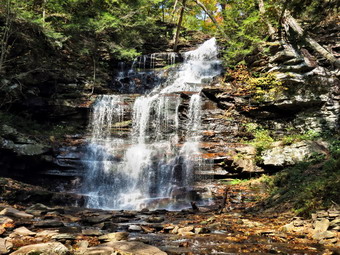 I stopped at Murray Reynolds and took some pictures by walking down to the stream bed. The water had enough volume to make the falls interesting but not enough from preventing positioning for good shots. The sun was still low in the sky making the lighting good. The basic story of my hike was hike to the next falls, walk to the stream to find a good angle, wait for people to clear out, take pictures and repeat. A brochure at the trailhead has a great map and descriptions of the various falls. Each one is just a little different and many change with water volume. I stopped at the next to falls and then arrived at Watersmeet where Ganoga Glen and Glen Leigh meet. I decided to head up Ganoga Glen and the return by way of Glen Leigh. From this point on the trail gets steeper and there are numerous wooden walkways and bridges. I will not take the time here to describe all the falls or my approach but a description of the falls and maps of the park are available on the Pennsylvania Department of Conservation and Natural Resources website.
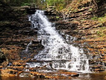 I hiked along saying "Hello" to various groups and talking to some of the photographers. I made a slightly longer stop at 94 foot Ganoga Falls, the highest in the park. I watched some people take chances on the slippery rocks in the stream that even I would not consider! By 12:35 PM I had hiked 3.6 miles and was at the top of Ganoga Glen. I stopped briefly for a drink and to get out a sandwich for lunch. I turned right on the Highlands Trail to get to the trail through Glen Leigh. This trail is almost exactly a mile long and I began to meet more people as many had started up Glen Leigh or had parked at the upper Lake Rose parking area. I turned down Glen Leigh and repeated the sequence of hiking and taking pictures. Hiking down the slippery trails and stone steps was a little more unnerving than hiking up. By this time the sun was beginning to shine down into the glen but seemed to go under a cloud each time I stopped for pictures. This was a good thing since the light was better for photography. I made a mental note to reverse my hiking direction next time!
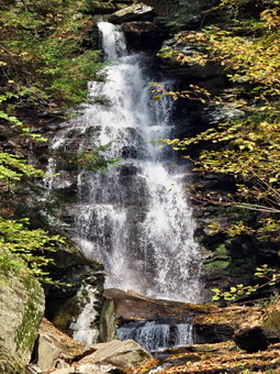 It wasn't very long before the trail began to flatten and the last few waterfalls came into view. By 1:50 PM, I was back at Waters Meet after hiking 5.8 miles. I began the 1.7 mile walk back to the parking area. It was pleasant to just be able to hike without "worrying" about taking pictures. As I was headed toward the parking area there were still many people coming up then trail. It was hard to tell which groups were just beginning and which were turning to complete the loop. When I got back to the parking area, I headed across the road to Adams Falls, the last one in the park. This falls has made a deep cut in the rocks. There is a deep plunge pool at the end and it is evident that the stream has cut through the rock over the years. I thought about hiking the Evergreen Trail below this falls but decided against it as I was a little tired and knew I had more than a two hour drive home. Earlier in the day I had considered heading a little west to Heberly Run and Sullivan Branch. These two streams have some nice waterfalls and are in a game management area. Since they are undeveloped and have no trails they feel wilder and there are fewer people. The last time I was there the water level was low so that I could walk up the stream bed. The downside was that the falls were less than spectacular. I wasn't sure how to get back to the area and I had no directions or map so I decided to leave them for another time. I walked back to the car and arrived at 2:35 PM having walked 7.8 miles in 4 hours with an ascent of over 1200 feet. I was surprised at my 2 mph pace because of all the stop I made totaling an hour! On the ride back I realized that I had not seen as much color as I wanted but the trip was definitely worth the effort.
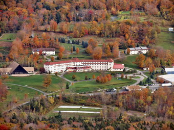
![]()
![]() On Monday, October 8th, I wanted to get one more chance to find same fall colors before they were all gone! I also wanted to hike some of the 35 peaks as I had the time and had not done one for some time. I decided to go to Tannersville to hike Indian Head and Twin from Platte Clove. The weather forecast was for partly sunny skies but with highs reaching only into the 50's. Sheila and I got started early but the drive was longer than I had remembered. We arrived at the Platte Clove Preserve a little after 9:00 AM to find quite a few cars parked by the side of the road. I knew there was a Lark in the Park hike but it looked like more cars than for that event. Sheila and I were on the trail by 9:15 AM under cloudy skies with the temperature in the low 40's. The first part of the trail from Platte Clove to the woods road and the beginning of the Devil's Path is usually wet and muddy and this day was no exception. This first mile is deceptive as the trade is gentle but the climb is around 400 feet. Along the way we met two hikers coming toward us with two dogs. I immediately leashed Sheila but the other two hikers made no effort to control their dogs. There we no problems but I think this attitude is what gives dog owners a bad name! A little further on we met a large group which I suspected were the Lark in the Park people. They also had two dogs which they did not bother to leash! We said "Hello" and Sheila and I continued up the trail. We made the right turn on the Devil's Path and I noted the sign that indicated another 1300 feet of climbing to the top. Sheila and I were making good time but I was not really trying to push it. I noticed I was a little tired and I was not surprised. I hike quite a bit over the summer but not as much as I usually do and not on the high peaks!
On Monday, October 8th, I wanted to get one more chance to find same fall colors before they were all gone! I also wanted to hike some of the 35 peaks as I had the time and had not done one for some time. I decided to go to Tannersville to hike Indian Head and Twin from Platte Clove. The weather forecast was for partly sunny skies but with highs reaching only into the 50's. Sheila and I got started early but the drive was longer than I had remembered. We arrived at the Platte Clove Preserve a little after 9:00 AM to find quite a few cars parked by the side of the road. I knew there was a Lark in the Park hike but it looked like more cars than for that event. Sheila and I were on the trail by 9:15 AM under cloudy skies with the temperature in the low 40's. The first part of the trail from Platte Clove to the woods road and the beginning of the Devil's Path is usually wet and muddy and this day was no exception. This first mile is deceptive as the trade is gentle but the climb is around 400 feet. Along the way we met two hikers coming toward us with two dogs. I immediately leashed Sheila but the other two hikers made no effort to control their dogs. There we no problems but I think this attitude is what gives dog owners a bad name! A little further on we met a large group which I suspected were the Lark in the Park people. They also had two dogs which they did not bother to leash! We said "Hello" and Sheila and I continued up the trail. We made the right turn on the Devil's Path and I noted the sign that indicated another 1300 feet of climbing to the top. Sheila and I were making good time but I was not really trying to push it. I noticed I was a little tired and I was not surprised. I hike quite a bit over the summer but not as much as I usually do and not on the high peaks!
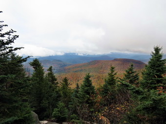 The trail continued to be wet and slippery due to the rainfall and the newly fallen leaves. I had Sheila off the leash most of the time which allowed me to use my poles. The trail ascends and levels several times while climbing toward the summit of Indian Head. The flatter portions were very muddy. By 10:20 AM we had hiked 2.2 miles and had over 1400 feet of elevation under our belts. We stopped at the lookout so that I could take some pictures. To the north the Catskill Community was clearly visible with Kaaterskill High Peak and Round Top in the background. There was some leaf color but many of the leaves were already down and the rest were not as vibrant as I had hoped. The scene was interesting as clouds and fog hung over the mountaintops and lingered in the valleys. We moved on as I knew the hardest climbs were yet to come. Our next stop after a short distance was the lookout to the south from the east or false peak of Indian Head. The sun had come out a little more and the leaves were brighter. After a few pictures, we walked down off the false peak and started the final ascent of Indian Head. We climbed a nearly vertical pitch and Sheila I not seem to have a problem. We stopped again so that I could take some pictures and then moved on The final obstacle was a narrow rock and root scramble with no other way around. As we approached Sheila barked and I saw another hiker going up through this section. When we arrived, I boosted Sheila up and told her to wait. Once I was up we continued along and met the other hiker. He was a young man from Ohio that had come to New York specifically to hike the Catskills. He was hiking the Devil's Path and intended to stay over at one of the lean-tos for at least one night. We hiked together for some time and exchanged information and stories. The approach to the summit was muddy and as we were finally nearing the top we met two more hikers. They were looking for a view and we advised them there wasn't much to see on Indian Head without descending to the lookouts. We continued in our separate directions. We arrived at the summit of Indian Head at around 11:20 AM after hiking 3.1 miles and gaining 1900 feet.
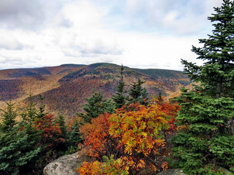 The top of Indian Head was in a cloud and there aren't any good views from the top anyway. The three of us began our descent to Jimmy Dolan Notch. The viewpoint toward Twin was obscured by trees and clouds so we did not stop. Once in the col we started up Twin. The hiker from Ohio was carrying a heavier load and decided to take a break. Sheila and I continued and ran into another spot where she needed a boost. We scrambled up some rather steep pitches which I remember from winter hiking. There steeper areas are challenging when dry. In the winter and early spring these areas tend to accumulated impressive ice flows which make hiking an adventure! We stopped at the lookout toward Indian head and I took some pictures. In some directions the skies were clear but in others there was still fog and clouds. At 12:05 PM we broke out onto the rock ledges on the east peak of Twin after hiking 3.9 miles. This point is one of my favorite viewpoints in the Catskills and this day was no exception. The views to the east were not the best but those to the south and west made up for it. Since there was another couple on the peak, I leashed Sheila to a tree before taking pictures. I took a lot of shot especially toward the west peak of Twin and Sugarloaf. After my photography session, Sheila and I had a drink and a snack and continued on toward the west and higher peak of Twin. The descent to the col was minimal and the ascent not too rigorous. We met another couple coming back from the west peak and greeted them as we passed. As we approached the west peak, I noticed that there were hikers there so I leashed Sheila to a tree before going to take pictures. The views from the west peak were not as broad or as beautiful as from the east peak but there was a nice view of Sugarloaf. Before we left I spoke to the other hikers and found that the young lady was from Monticello. I remembered her the she was a member of the track and cross country teams! As we starred back, the hiker from Ohio appeared.
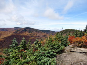 Other than the reclimb to the east peak I knew the rest of the way was downhill or flat. I also knew that we would have to descend Jimmy Dolan Notch which is one of the worst trails in the Catskills! On our way down twin we met a small family group coming up. Near the col we ran into the Lark in the Park group or what was left of it. I spoke to the leader for a minute before continuing down to the col. We turned left onto the Jimmy Dolan Notch Trail at 1:30 PM about 5.5 miles into the hike. The first part of the trail is steep and rocky. This gives way to roots and then rocks and roots. At times the trail would be hard to locate without the markers. On this day everything was wet and covered in slippery leaves. As we descended I congratulated myself on not falling after which...I fell. I picked myself up and continued along until...I fell again a little harder. From that point on I was VERY careful with my foot placement and was careful to use my poles. We met another couple and a hiker with his dog on the way down. This part of the hike did not ever seem like it would end and was every bit as annoying as I remembered. As we approached the Prediger Road parking area, a trail headed back over to the woods road that leads back to Platte Clove. I decided I was done with routes and rocks and would walk the roads back to the car. From the parking area we walked out Prediger Road to Platte Clove Road and turned right to the car. We passed the Catskill Community where members were working in the garden and we soon back at the car. We had covered 8.7 miles in a little over 5.5 hours and had ascend a total of 2700 feet. I had thought about visiting the falls in Platte Clove decided that would wait until another day!
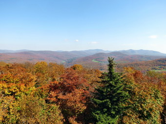
![]()
![]() On Friday, October 5th I decided to look for some fall colors somewhere. I wanted someplace close to home but with a nice view that had proven good for fall colors in the past. Red Hill fit the criteria so I got ready, put Sheila in the car and headed out DeBruce Road. At the end of Pole Road a sign still indicated that the road to Frost Valley was closed. I went the other way towards Claryville and over Red Hill Road to Coons Dinch Road. The dirt road down to the parking area was in decent shape. Several new homes are being built on the road. When we arrived at the parking area at 10:45 AM there were several cars parked and a bus from Frost Valley blocking most of the rest of the lot! I thought this was very inconsiderate but I was able to squeeze in next to the bus. We got on the trail immediately and headed up toward the fire tower. The trail had a lot of fallen leaves which made it slippery in places and there was some mud. Overall the trail was in good shape and we kept a fast pace. As the trail leveled in one spot Sheila and I both spotted two people ahead. It looked like a father and son and I thought, for a moment, it might be a member of my ambulance corps. As we got closer my suspicions were confirmed. I had suggested that he bring his son to Red Hill as it was short but had the tower at the end. We walked together and talked for a while until the trail got steeper and Sheila and I pulled ahead. As we neared the top we met the group from Frost Valley coming down from the peak. They all seemed nice so I didn't mention the bus problem. By 12:20 PM we had hiked the 1.25 miles to the top. I hooked Sheila to a picnic table so that I could climb the tower to get some pictures. The colors were nice but not spectacular. After taking a few shots, I came down and Sheila and I had a snack. I talked to the volunteer that was at the cabin. He was from Grahamsville and I had met him before. The trip down went even faster and as we approached the parking area I could see the group just boarding there bus. We were back at 12:15 PM having covered 2.5 miles in 1.5 hours including our stops. We were now off to Angel Falls.
On Friday, October 5th I decided to look for some fall colors somewhere. I wanted someplace close to home but with a nice view that had proven good for fall colors in the past. Red Hill fit the criteria so I got ready, put Sheila in the car and headed out DeBruce Road. At the end of Pole Road a sign still indicated that the road to Frost Valley was closed. I went the other way towards Claryville and over Red Hill Road to Coons Dinch Road. The dirt road down to the parking area was in decent shape. Several new homes are being built on the road. When we arrived at the parking area at 10:45 AM there were several cars parked and a bus from Frost Valley blocking most of the rest of the lot! I thought this was very inconsiderate but I was able to squeeze in next to the bus. We got on the trail immediately and headed up toward the fire tower. The trail had a lot of fallen leaves which made it slippery in places and there was some mud. Overall the trail was in good shape and we kept a fast pace. As the trail leveled in one spot Sheila and I both spotted two people ahead. It looked like a father and son and I thought, for a moment, it might be a member of my ambulance corps. As we got closer my suspicions were confirmed. I had suggested that he bring his son to Red Hill as it was short but had the tower at the end. We walked together and talked for a while until the trail got steeper and Sheila and I pulled ahead. As we neared the top we met the group from Frost Valley coming down from the peak. They all seemed nice so I didn't mention the bus problem. By 12:20 PM we had hiked the 1.25 miles to the top. I hooked Sheila to a picnic table so that I could climb the tower to get some pictures. The colors were nice but not spectacular. After taking a few shots, I came down and Sheila and I had a snack. I talked to the volunteer that was at the cabin. He was from Grahamsville and I had met him before. The trip down went even faster and as we approached the parking area I could see the group just boarding there bus. We were back at 12:15 PM having covered 2.5 miles in 1.5 hours including our stops. We were now off to Angel Falls.
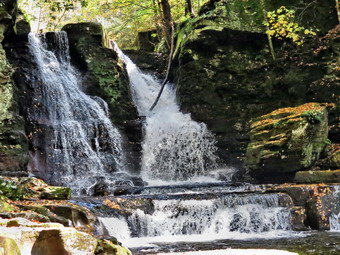 I drove down Sugarloaf Road and took a right at the end and then a left on Route 55A around the Rondout Reservoir. Just before the dam I turned left on Yagerville Road and then right on Shalom Road and parked at the dead end. The land is owned by the DEP but has been opened to hikers for some time. We walked down the old road to the upper falls and then took the path along the gorge. The path down to the falls is more prominent each time we visit. The volume of water was adequate but less than I had expected. I took some shots from different angles and then we headed back up the bank. The path continued along the high bank heading downstream to the lower falls. I leashed Sheila to a tree as she really loves the water. I took some shots of the lower falls from close up and then headed downstream to take a few more. Sheila voiced her distress by barking until I returned. We headed back up to the car after a short but enjoyable outing.
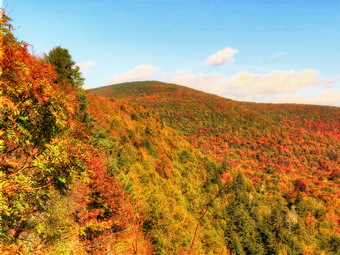
![]()
![]() On Thursday, September 27th I decided to look for some fall colors somewhere. I wanted someplace close to home but with a nice view that had proven good for fall colors in the past. Giant Ledge fit the criteria so I got ready, put Sheila in the car and headed out DeBruce Road. When I made the turn onto Route 47, the Frost Valley Road, I was surprised to find a Road Closed sign. Since the sign allowed for local traffic I made the turn. Just passed the sign the road was down to barely one lane as the Neversink River had washed away the road surface. After the storms last fall, the road crews had done a lot of work including placing large boulders to protect the banks from erosion. Some of these boulders had been swept aside and others proved ineffective. Further up the road toward Frost Valley there were areas where over a foot of silt had been removed from the road. Other places had cones indicating the should was undermined. Some of the road crews said that the damage done this time in the Claryville area was worse than last fall! I continued to drive passed Frost Valley and both the Biscuit Brook and side Mountain trailheads. The road there was in better shape but deteriorated again from Winnisook Lake Down to the parking area for Giant Ledge. We arrived at 10:15 AM to find several cars in the lot. We crossed the road and started hiking almost immediately. The trail was wet and muddy in post but was in pretty good shape. As we hiked up one of the five or six rocky areas, we met a couple resting. I talked to the two hikers for some time and found out this was their first time at Giant Ledge. We said goodbye and Sheila and I continued on up the trail. By 10:45 AM we had hiked the .73 miles to the trail junction and turned left to go to Giant Ledge
On Thursday, September 27th I decided to look for some fall colors somewhere. I wanted someplace close to home but with a nice view that had proven good for fall colors in the past. Giant Ledge fit the criteria so I got ready, put Sheila in the car and headed out DeBruce Road. When I made the turn onto Route 47, the Frost Valley Road, I was surprised to find a Road Closed sign. Since the sign allowed for local traffic I made the turn. Just passed the sign the road was down to barely one lane as the Neversink River had washed away the road surface. After the storms last fall, the road crews had done a lot of work including placing large boulders to protect the banks from erosion. Some of these boulders had been swept aside and others proved ineffective. Further up the road toward Frost Valley there were areas where over a foot of silt had been removed from the road. Other places had cones indicating the should was undermined. Some of the road crews said that the damage done this time in the Claryville area was worse than last fall! I continued to drive passed Frost Valley and both the Biscuit Brook and side Mountain trailheads. The road there was in better shape but deteriorated again from Winnisook Lake Down to the parking area for Giant Ledge. We arrived at 10:15 AM to find several cars in the lot. We crossed the road and started hiking almost immediately. The trail was wet and muddy in post but was in pretty good shape. As we hiked up one of the five or six rocky areas, we met a couple resting. I talked to the two hikers for some time and found out this was their first time at Giant Ledge. We said goodbye and Sheila and I continued on up the trail. By 10:45 AM we had hiked the .73 miles to the trail junction and turned left to go to Giant Ledge
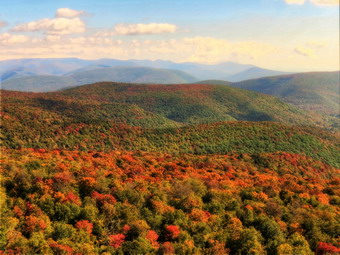 We walked quickly along the flat area of the trail trying to stay out of the mud. Along the way we met three young men who had camped overnight at Giant Ledge. In the course of conversation, they mentioned that there were some nice colors in the views form them ledges. I was surprised that Sheila all but ignored them even though tow were wearing hats! Soon we were climbing passed the trail to the spring and were headed toward the last climb to the ledges. The weather had warmed from the low 50's to the 60's and I had removed my light softshell some time before. The last climb went quickly and we were at the first lookout by 11:05 AM having hiked 1.4 miles. The colors were certainly not as bright as I would expect at "peak" but they were very nice. I took a variety of shots including an eight shot set to turn into a panorama. I also found out that my new Canon SX40 will bracket photos for HDR. I set if to take a -2 exposure and a +2 exposure in addition to the "normal" shot. The camera takes three pictures in a surprisingly short time. HDR software can then be used to combine the shots into one picture. We had a drink and a snack and then walked to two more lookouts. The views don't change too much along the ledges but from some places Panther Mountain is easier to see and from other you can get a good view of the Burroughs Range. After I took some more pictures, we headed back down. Just after descending the first rock scramble, we met a solo hiker on his way up. We were both moving pretty fast so we said hello and then continued along. After only a few moments, we met the couple that we had spoken to earlier in the hike. Before we parted again, they asked what there was to do in the Big Indian area on a rainy day. My first thought was "Nothing!" and after some more thought my answer did not change. We continued in apposite directions. Just after the spring we met another hiker and his dog. Sheila seemed to get along okay with his Basenji mix! We talked for a few moments and he indicated that the fall colors around his home in Andes were very nice. Soon Sheila and I made the turn to the right at the trail junction and were headed down the rock scrambles to the car. We met pone more couple headed up. We arrived back at the car at 12:25 PM having covered 3.3 miles in just over 2 hours with plenty of time for stops!
![]()
![]() On Tuesday, September 25th I wanted to get in a hike close to home before cross country practice. I chose to go to Frick and Hodge Ponds since the area is close and I wanted to check out the progress of the fall color change. Sheila and I arrived at the parking area and were hiking by 10:10 AM. I decided to see how Sheila would do without her training collar and hoped she would obey all my commands. The woods road out to Frick Pond was wet and a little muddy in places. I tested Sheila several times and she always came to me or got back on the trail when commanded. When we got to the pond, I immediately noticed that many of the leaves were turning colors. The colors were not particularly bright but it was nice to see the contrast. The sky was blue but there we few clouds so it was not an ideal day for photography but I took a few pictures anyway. Sheila spent some time in the shallow water at the inlet before we crossed the bridge to pick continue the hike. We stayed on the Quick Lake trail at the first junction and I noticed that many of the trees is that area had already lost their leaves. The storm a week ago had some high winds that may have been responsible. We continued on the Quick lake trail and avoided the numerous blowdowns which have become a part of the hike. Sheila played in the small stream across the trail before we got to Iron Wheel Junction. The leaves on this part of the trail had not turned and most were still on the trees. We arrived at the junction at 10:45 having covered 1.4 miles.
On Tuesday, September 25th I wanted to get in a hike close to home before cross country practice. I chose to go to Frick and Hodge Ponds since the area is close and I wanted to check out the progress of the fall color change. Sheila and I arrived at the parking area and were hiking by 10:10 AM. I decided to see how Sheila would do without her training collar and hoped she would obey all my commands. The woods road out to Frick Pond was wet and a little muddy in places. I tested Sheila several times and she always came to me or got back on the trail when commanded. When we got to the pond, I immediately noticed that many of the leaves were turning colors. The colors were not particularly bright but it was nice to see the contrast. The sky was blue but there we few clouds so it was not an ideal day for photography but I took a few pictures anyway. Sheila spent some time in the shallow water at the inlet before we crossed the bridge to pick continue the hike. We stayed on the Quick Lake trail at the first junction and I noticed that many of the trees is that area had already lost their leaves. The storm a week ago had some high winds that may have been responsible. We continued on the Quick lake trail and avoided the numerous blowdowns which have become a part of the hike. Sheila played in the small stream across the trail before we got to Iron Wheel Junction. The leaves on this part of the trail had not turned and most were still on the trees. We arrived at the junction at 10:45 having covered 1.4 miles.
 We turned left at the junction and headed up the Quick Lake trail toward Junkyard Junction. The trail was wet in spots along the way and it was obvious from the new erosion that there had been significant rain in this area. These trees also showed little color change. By 11:20 AM we had hiked the 3 miles to Junkyard Junction where we turned right on the Flynn Trail to head toward Hodge Pond. The Flynn Trail is relatively flat and it was wet for most of the length. At one point a small tree made quite a noise as it fell to the forest floor just off the trail to our left. We stayed on the trail by bearing right at the gate and headed down to the pond. At the junction with the jeep road we turned left to go around the back of the pond. We walked down to the shore of the pond so that I could take some pictures and Sheila could frolic in the water. The leaves at Hodge Pond were not as colorful as at Frick Pond but the view was still nice. the sun sparkled off the water but there were few clouds in the sky. Sheila was running through the water and onto land repeatedly. I decided to throw a stick to see if she would go into deeper water to retrieve it. After I threw the stick, she jumped in and waded as far as she could go and then swam out to get it. She seemed to like this as we repeated it several times so that I could get some pictures. The only drawback was that she would shake the water off herself right next to my pack each time! We continued on around the pond and stopped at the outlet. I took more pictures and Sheila chased the stick I threw until it was time to head back to the car. It was 11:50 Am and we had hiked 4.3 miles.
 Sheila and I continued up the Flynn Trail toward the junction with the Big Rock Trail. This is about .7 miles as is a gentle uphill most of the way. At the junction we walked straight ahead to take the Flynn Trail back to the parking area. Sheila was behaving very well and was responding to voice commands. At one point several birds took off on our right but she came right back when I called. I decided to visit the clearing on the left of the trail at about 5.6 miles into the hike. We walked off the trail and up to the open meadow. The meadow seemed as if it had been dry. There wasn't much leaf color but I took a series of pictures. I am still experimenting with the new camera and some different pieces of software. I wanted to create a panorama so I took three pictures across the skyline and three pictures of the meadow below that. On their own they were nice but I wanted to stitch them together into one picture. We walked back to the trail and continued toward the parking area. This part of the trail is downhill and our pace increased. We were back at the car by 12:45 PM having covered 6.8 miles in 2 hours and 35 minutes with a modest elevation gained of just over 1000 feet. I look forward to going back to see what the fall color change will bring.