| Pick a Catskill 35 Peak: |
Peekamoose Mountain
This mountain is often climbed in conjunction with Table Mountain and can be done from the Denning trailhead or from the trailhead on Peekamoose Road. The climb either way is steady.
| Trailhead Coordinates | |
|---|---|
| Name | Coordinates |
| Denning PA | N41.9654 W74.4527 |
| Peekamoose Road | N41.9150 W74.4290 |
| Moonhaw Road | N41.9847 W74.3278 |
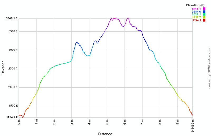
| Quick Look - Peekamoose and Table from Peekamoose Road | ||||
|---|---|---|---|---|
| Difficulty | Round trip | Total climb | Location | Internet Maps |
| 8.7 mi. | 2453 ft. | N41.9531 W74.3986 | AllTrails | |
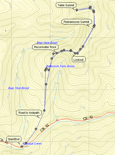
Turn onto Route 52A near the TriValley School. Stay on the road until the hamlet of Sundown where
the road turns left. Bear to the left on Peekamoose Rd. and continue on the road until parking areas
begin to show up on the left. The parking area most use to climb the mountain is the sixth marked spot
and indicates the beginning of the Peekamoose-Table trail. Park here and start up the blue-blazed
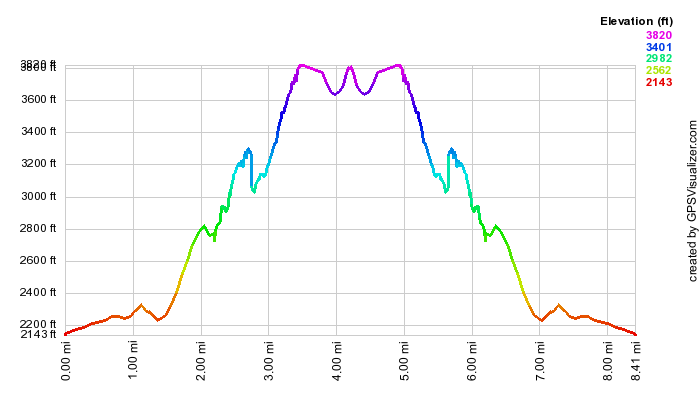
trail. After 2.3 miles you reach Reconnoiter Rock which has a nice view. Climb for about .75 miles
and there is a rock ledge with opens views to the south. The summit of Peekamoose Mountain (3843 ft.)
is .85 miles further. The trail then descends into a col between the two mountains before it rises to
the flat ridge that is Table Mountain. After .85 miles, you are on the summit of Table Mountain (3847 ft.)
The Trail continues on to the Denning trail head but your car is back on the Peekamoose Rd. Turn around
and retrace your route to the car.
| Quick Look - Table and Peekamoose from Denning | ||||
|---|---|---|---|---|
| Difficulty | Round trip | Total climb | Location | Internet Maps |
| 8.6 mi. | 2723 ft. | N41 57.52 W74 24.32 | AllTrails | |
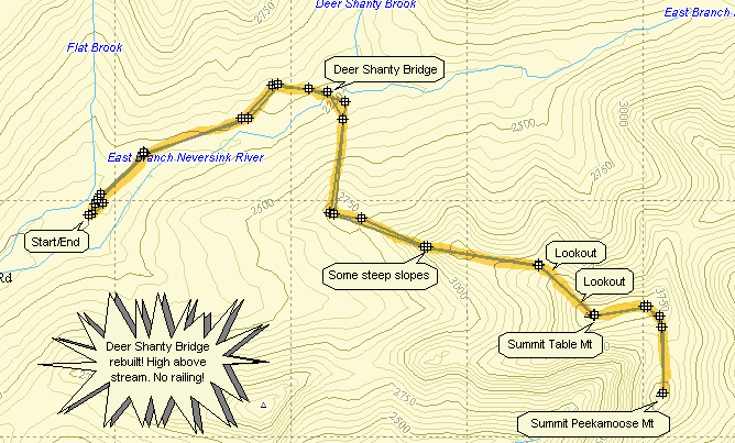
Turn onto County Route 19 (Claryville Road) from State Route 52 in Curry between Neversink and Grahamsville. Stay on the road until the hamlet of Claryville. Continue through Claryville where the name of the road changes to the Denning Road. Stay on this road until you run out of road. Park in the Denning Trail Head lot. Get on the yellow-marked Phoenicia-East Branch Trail and hike for about 1.2 miles. At this point the blue-marked Peekamoose Table Trail turns to the right and heads down to the East Branch of the Neversink River and Deer Shanty Brook. After .3 miles, there will be a log bridge cross the East Branch. This bridge washes out at times and the river may not be easily crossed! The trail now heads toward Table Mountain with several smaller hills to cross before the main ascent. Just after 3000 ft there is a very obvious lookout on the right which has a nice view to the south. After about 2 miles, there is a small spring on the left which can dwindle to nothing in dry weather. In another .1 miles, there is a spur trail to the right that leads to a lean-to. Shortly a sign announces the 3500 ft elevation. Keep your eyes open for another short trail to the right which leads to a small outcropping of rock. This is another lookout facing south. There are several other places on this trail that hint of views both to the south and north but foliage in the summer blocks these views. The hiking gets steep now for the last .2 miles at which time you have arrived at the summit of Table Mountain. The hike to Peekamoose is only .85 miles more and the drop into the Col between them is minimal. Peekamoose doesn't offer many vies but the trail near the top is interesting. After reaching the summit of Peekamoose, retrace your steps back to the parking lot.
| Quick Look - Peekamoose from Peekamoose Road | ||||
|---|---|---|---|---|
| Difficulty | Round trip | Total climb | Location | Internet Maps |
| 7.4 mi. | 2572 ft. | N41 57.18 W74 23.92 | AllTrails | |
Turn onto Route 52A near the TriValley School. Stay on the road until the hamlet of Sundown where
the road turns left. Bear to the right on Peekamoose Rd. and continue on the road until parking areas
begin to show up on the left. The parking area most use to climb the mountain is the sixth marked spot
and indicates the beginning of the Peekamoose-Table trail. Park here and start up the blue-blazed
trail. After 2.3 miles you reach Reconnoiter Rock which has a nice view. Climb for about .75 miles
and there is a rock ledge with opens views to the south. The summit of Peekamoose Mountain (3843 ft.)
is .85 miles further. The Trail continues on to the Denning trail head but your car is back on the Peekamoose Rd. Turn around and retrace your route to the car.
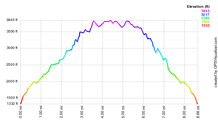
| Quick Look - Van Wyck, Table and Peekamoose from Denning | ||||
|---|---|---|---|---|
| Difficulty | Round trip | Total climb | Location | Internet Maps |
| 9.9 mi. | 3395 ft. | N41 57.52 W74 24.32 | AllTrails | |
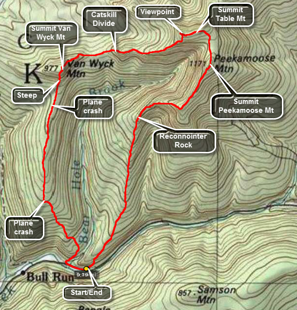
Van Wyck, Table and Peekamoose Mountains can be hiked together combining a bushwhack with trails. Going To Van Wyck and over to Table on the bushwhack first allows a return to the car on trails. The route from Van Wyck to Table lies on the Catskill Divide which forms a natural path between them.
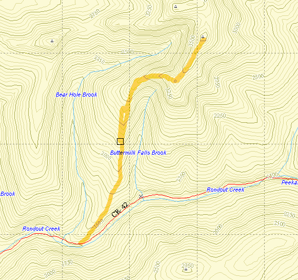
Turn onto Route 52A near the TriValley School. Stay on the road until the hamlet of Sundown where the road splits. Bear to the left on Peekamoose Rd. and continue on the road until parking areas begin to show up on the left. The parking area used to climb Peekamoose and Table Mountains is the sixth marked spot and indicates the beginning of the Peekamoose-Table Trail. You may park at these spots or at the pulloff near Bear Hole Brook.
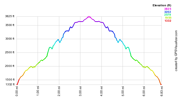
From Bear Hole Brook head north and UP toward Van Wyck. The initial hike may be steep in places. If you find a road, you may follow it as long as it heads in the general direction. The contour maps show a "finger" of land pointing down from the summit. It is best to head for this area. Once on this "finger" the hike is somewhat flat with gentle elevation gain until you get to the base of the mountain. Along the way you may find some old foundations and two plane crashes. If you head directly north to the summit expect about .2 miles of near vertical ascent. On the ascent stop to look over your shoulder. There are some flat rocks that act as viewpoints. An easier path may be to head to the west and up to the ridge and then east to Van Wyck. Once on the summit plateau wander around some until you feel you have hit the highest spot. Be sure to walk along the eastern edge of Van Wyck to get a spectacular view of Table and Peekamoose. The summit of Van Wyck is about 3.3 miles from the start of the hike. From Van Wyck stay on the "high ground" of the Catskill Divide even though it adds a little distance and does not look like a direct route. Your route should take you slightly north of east all the way to Table. The initial drop to the col is about 400 feet and as you climb this elevation again you will run across at least one "bump" to climb ad descend. The last short climb up Table can be interesting as it is covered with thick stands of fir trees! When you push your way through, be sure you hit the summit. You will be about 5.3 miles into the hike with the hardest part behind you. You will pro ably want to turn left on the trail and walk a little west to the side trail that visits a nice lookout. Back on the main trail turn right and head east and then south to the summit rock of Peekamoose mat around 6.2 miles. It is a LONG 3.6 miles back to the car but it is all on trail. As you descend from Peekamoose you will walk across some flat areas. Watch for viewpoints in this area. Further down the mountain you can stop at Reconnoiter Rock, a large boulder perched precariously and seemingly balanced. Continue on to the car for a well-deserved rest before the drive home.