
"Other" Trails
Besides the thirty-five 3500 foot peaks in the Catskills, there are many other smaller mountains to climb. In addition, there are hundreds of miles of trails to hike. There are also MANY other places to hike also. I have divided the Trails section into list of All Trail, the Catskills, the Shawangunks, Bear Mt/Harriman, East Hudson, West Hudson, New Jersey and Other Trails. The All Trails list includes over 400 different trails and may load slowly on your computer. The "divided" list should load more quickly.
You can view all the "Other" Trails here.
Clicking on ![]() will bring up an index of trails. Clicking on
will bring up an index of trails. Clicking on ![]() will return you to the top of the page.
will return you to the top of the page.
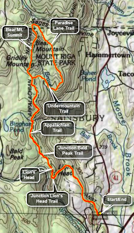
Bear Mt. And Lion's Head (CT)
| Quick Look | ||||
|---|---|---|---|---|
| Difficulty | Round trip | Total climb | Internet Maps | |
| 13.2 mi. | 3205 ft. | AllTrails | ||
 Bear Mt. is the highest peak in the state but the highest point is further north and west on the shoulder of Mount Frisell which is mostly in Massachusetts.
Park at the AT parking lot .8 miles north of the Route 44/Route 41 junction in Salisbury, CT. on Route 41. The entrance to the parking area is VERY narrow and not well marked. The parking area will accommodate 8 to 10 cars and is a popular place for many day hikers. The trailhead has a large signboard and a privy maintained by the AMC. The first part of the trail to the Lion's Head is wide and pretty smooth and the elevation gain is minimal. Several turns and switchbacks make the climb even easier. At about 1.4 miles you will cross a running stream with cool, clear water. At just over 2.0 miles the Lion's Head Trail joined from the left coming in from Bunker Hill Road. From this junction the trail becomes rockier and harder to walk. It also becomes much steeper as it ascends the Lion's Head with the very last part being an open rock outcrop. After another .25 miles, at about 2.3 miles into the hike, you will arrive at the viewpoint known as the Lion's Head. The views from here are expansive but be prepared to share the view with others! Leave the Lion's head and continue on the AT north toward Bear Mt. At 2.64 miles the Bald Peak Trail joins the AT from the left. The AT in this area is not exposed but instead runs under a leafy canopy most of the way meaning that it is protected but has no views. Along the way to Bear Mt. there are several places to camp and a few water sources. The Riga Lean-to comes up at 3.0 miles into the hike, followed by the Ball Brook campsite at 3.5 miles and the Brassie Brook Lean-to at 4.25 miles. In another .6 miles you will arrive at Riga Junction where the Undermountain Trail comes in from Route 41. Continue on the AT to the junction with Bear Mt. Road at 5.0 miles. From here the trail becomes much rockier and steeper. The AT winds up and over many rocky outcrops offering some limited viewpoints. You arrive at the summit of Bear Mountain at about 5.55 miles and the elevation is 2330 feet. At the top of the mountain is a stone pyramid more than large enough to accommodate 20 people. You can walk to the top of the pyramid to get views to the north and east but the views west and south are limited. To hike a loop head down the north side of Bear Mt. on the AT. The AT down Bear Mt. To the north is very steep. Most northern sides of mountains in this area are steeper than their southern counterparts due to the way glaciation eroded the rock. At a little more than 6.0 miles you will cross the border into Massachusetts and then arrive at a trail junction. Straight ahead the AT leads to Sage's Ravine. Turn right on the Paradise Lane Trail which immediately begins to gain some elevation. At 6.5 miles you will pass the Paradise Lane Group Campsite. From here the trail is flat or slightly downhill for the next 1.15 miles until you reached the junction with the Undermountain Trail at 7.6 miles. Turn right on the Undermountain Trail and start toward the AT at the Riga Junction. At 7.9 miles there is a bog. At 8.6 miles you will be back on the AT where you should turn left to head back to the Lion's Head and eventually the car. A long 2.4 mile stretch of the AT put you back at the Lion's Head. The hike back to the car is downhill.
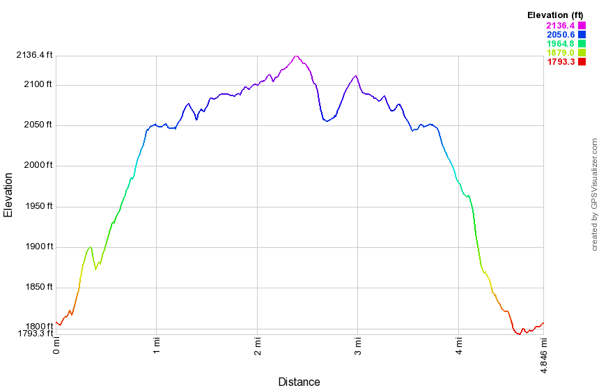
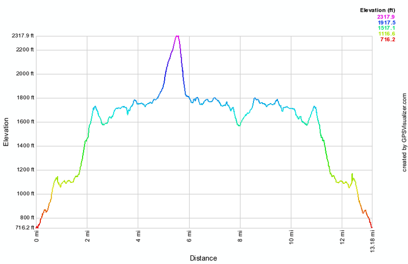 (The image at the left shows the profile of the hike. Remember that all vertical profiles are relative!)
Big Pocono: North and South Trails
| Quick Look | ||||
|---|---|---|---|---|
| Difficulty | Round trip | Total climb | Internet Maps | |
| 7.9 mi. | 1300 ft. | AllTrails | ||
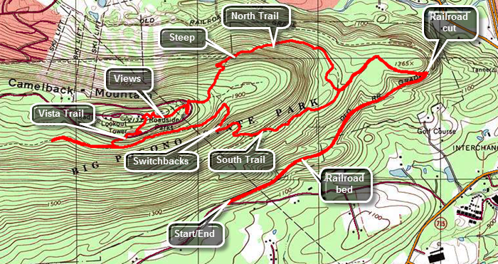 Big Pocono State Park near Mount Pocono, Pennsylvania is also the home of Camelback Mountain Ski Resort. There are nice views especially from the Indian Trail but the trails are poorly marked. There is a "healthy timber rattlesnake population" in the park. Those not wishing to hike to the top of the mountain may drive there to enjoy the views. The easiest way to get to the trailhead is to take I80 to exit 45. Drive south on Route 715 and turn right on Railroad Drive. Drove 1.2 miles to the trailhead which is marked with a sign indicating "Riday Gate" and an arrow showing "Big Pocono State Park". You may park near the gate on the right side of the road where there is room for two or three cars. There is also a spot on the opposite side of the road for about the same number of vehicles. The first part of the trail is an old railroad grade and is easy to spot. The railroad bed is well maintained, flat and smooth. In several places the trail passes through small rock cuts. As you near the spot where the trail turns up the mountain the railroad bed is built up to span a gully. At 1.3 miles the trail turns off the railroad bed and heads up the mountain in a sharp switchback. Continue to walk straight ahead to investigate the railroad cut through the rocks. This cut is more expansive than the others. Return to the trail and begin to climb the mountain. The trails are not very well marked and branch in several places. Sometimes to get to one trail you have to hike part of the way on another. The blazes are not clear and the railroad bed does not have any but they are not really necessary as it is easy to follow. At just over 1.6 miles pass a small pond off the trail on the left and then continue to follow the trail as it turns and continues to climb to a junction at 1.9 miles. Turn to the right on the North Trail which is sheltered by trees but offered no views at all. The trail does offer a pretty steep climb gaining over 600 feet in about .75 miles to Rim Road on the summit. Along the way there are several intersections with paths and trails which were quite confusing as there were no signs. Keep bearing right in each case. At one point you will come to the edge of one of the ski slopes with a limited view. At 3.1 miles intersect Rim Road and cross it into a parking lot. The trail continues straight ahead. You may ant to detour to the left and walk to the edge of the parking lot to get a view to the south and east. Walk back to where the trail crossed the road and hike .2 miles to a parking area at the top of the mountain at about 3.4 miles. A radio tower is to the left and with the old park office building next to it. To the right is an open space where a lookout tower once stood. It is still marked as present on many maps. Take some time to walk around the area and take in the views. Watch for a sign that explains that the park has a "healthy population of timer rattlesnakes". Walk over toward the bathrooms and find a round "table". The table is stainless steel with a stone mosaic on the surface. There is a large arrow and the names of various landmarks. When the opposite end of the arrow encircles the name of a landmark, the other end of the arrow points to that landmark. It is very interesting to see that it is an Eagle Scout project. Head south just passed the bathrooms and down to a parking area to pick up the South Trail for the return trip. At the parking area, turn to the right and exit the lot. Cross Rim Road and find the Vista Trail that connects to the South Trail. The trail was very short. When you hit the South Trail you may want to turn right to investigate a little but there are no views in this direction. To the left of the terminus of the Vista trail is a...vista. with limited views to the south. Continue on the South Trail which for the first half mile is flat or a little uphill. At about 4.9 miles begin the descent back to the car. The trail is very rocky and there are several switchbacks. Switchbacks are a blessing and a curse as they mitigate the steep grades but lengthen the hike. At the end of the third switchback your car is only .3 miles away but the terrain is very steep and may contain some of those rattlesnakes. As it is that .3 miles turns into a 2.4 mile walk! As you descend you will come to a junction with the Indian Trail where you should continue to follow the South Trail back to the point where you turned right onto the North Trail earlier. Walk down to the railroad cut and turned right to follow the railroad bed back to the car.
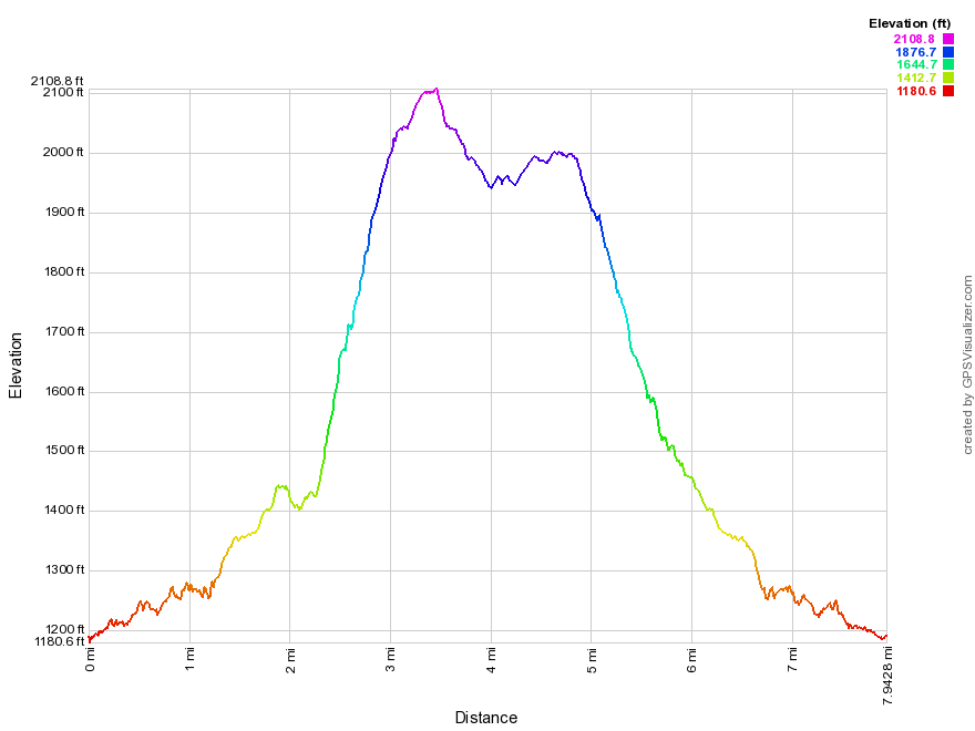 (The image at the left shows the profile of the hike. Remember that all vertical profiles are relative!)
Buttermilk Falls State Park (NY)
| Quick Look | ||||
|---|---|---|---|---|
| Difficulty | Round trip | Total climb | Internet Maps | |
| 2.0 mi. | 760 ft. | AllTrails | ||
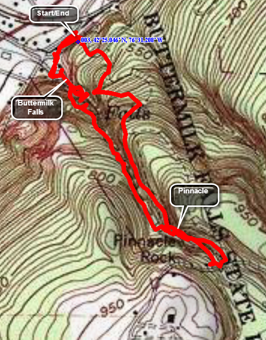
Head south on Route 13 from Ithaca, New York. Watch for signs for East Buttermilk Falls Road and Buttermilk Falls State Park on your left. The main Buttermilk Falls area is a popular swimming area and it may be hard to get good pictures of the falls from below. Walk through the swimming area to pick up the trail on the west rim of the gorge on the Gorge Trail. As you walk up the first set up steps you may be able to get better pictures. The main "falls" simply has water that passes over a wide expanse of harder bedrock and does not really fall. Over the years the stream has cut an interesting path through the rock forming the gorge. You will soon be at another falls without a sheer drop but one that is narrower and, therefore, seems to be faster flowing. As you continued along the path, you will see how the stream has meandered along the gorge and causing many different and interesting formations. Another falls will appear soon as the water passes through a narrow slot in the rocks. In several places the swirling water has cut circular "pools" in the rock which are deep with rather large diameters. More falls and more interesting formations appear along the way as the path continues climbing up the gorge. At the top of one set of steps you will see a nice three-tiered cascade. There is a lean-to on the right of the trail. Pass by the bridge that crosses the stream to make sure you see the whole gorge. There are several more falls and interesting rock formations and then you will be at Pinnacle Rock. Here a spire of rock has either pulled away from the gorge wall or, more likely, is of greater hardness than the surrounding stone. In any case, it is quite impressive standing tall right next to the path. The pattern of falls, plunge pools, and slots continues as you walk to the head of the gorge but they become less frequent as the stream volume deceases. Cross the next bridge to get to the Rim Trail on the east side of the gorge. This trail descends for most of its length but has at least one area that drops to the gorge before climbing again to the rim. In several places the trail meets a service road and the path was not well marked. The Rim Trail will take you back to the parking area.
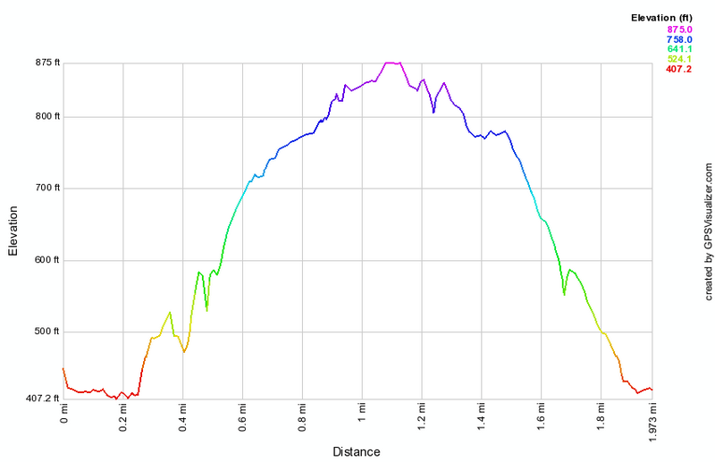 (The image at the left shows the profile of the out and back hiking route. Remember that all vertical profiles are relative!)
Clapper Hollow Loops
| Quick Look | ||||
|---|---|---|---|---|
| Difficulty | Round trip | Total climb | Internet Maps | |
| 4.8 mi. | 490 ft. | AllTrails | ||
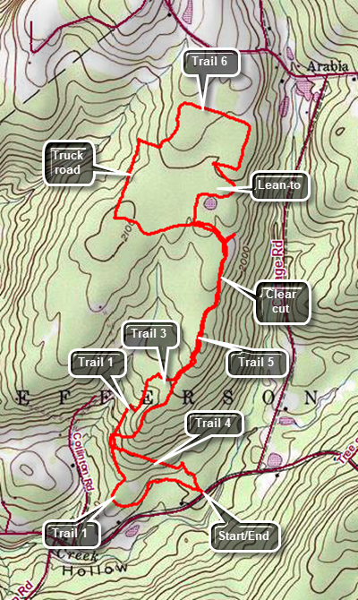 The trail in this area are not always well marked and there are many logging roads and informal paths. I suggest you print out the map you find here. This description is based on an actual hike with corrections for the extra explorations that went nowhere
Drive north on Route 10 from Jefferson in Schoharie County for a little more than 2 miles. Turn left on Moxley St (Route 15). Make an immediate right on Clapper Hollow Road and drive a little less than 1 mile to the parking area on the right. Leave the parking area walking straight ahead on Trail 4. Walk for about .4 miles and then turn right or north on Trail 1. Walk mostly northeast on Trail 1 to .8 miles where it intersects with Trail 5. Turn left and walk uphill to 1.5 miles passing through a clear cut area. At the junction, turn right on Trail 6 and follow it to the lean-to and pond at 1.7 miles. Take some time to relax at the pond and then continue to follow Trail 6 as it makes a loop above the pond. The trail will zig-zag and then make a rectangular loop. At about 2.5 miles be careful to watch for the point where Trail 6 turns off the logging road and heads southwest briefly and then west to a road. Turn right on the road and walk down to the Clapper Hollow Truck Road. Turn left and walk along the road to 3 miles. Turn left on Trail 5 as the truck road comes to a dead end a little further on. Walk east on Trail 5 to 3.25 miles when you will have come back to the junction with Trail 6. Turn right and continue to 4 miles. Continue straight ahead on an informal path to 4.25 miles where you will again pickup Trail 1. Continue straight ahead to do a short loop. Continue to follow this trail back out to the parking area.
 (The image at the left shows the profile of the counterclockwise loop hiking route. Remember that all vertical profiles are relative!)
Cobey Pond (PA)
| Quick Look | ||||
|---|---|---|---|---|
| Difficulty | Round trip | Total climb | Internet Maps | |
| 2.2 mi. | 245 ft. | AllTrails | ||
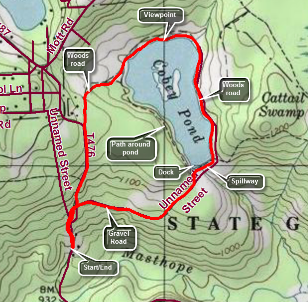
Cross the Delaware River into Pennsylvania at Narrowsburg, NY and drive west for 4 miles on SR 652. Turn left or south on Perkins Pond Road. Stay on Perkins Pond Road for 4 miles until it ends at Welcome Lake Road. The name of the road changes to Case Road as you enter the Township of Lackawaxen. Turn right on Welcome Lake Road and drove .9 miles to Masthope Road. Turn left and watch for the access road for Cobey Pond about 1 mile down the road on the left. Turn into the road and cross Masthope Creek on a small bridge. DO NOT park in the first lot but continue on the gravel road to the left. In about half a mile you will come to an upper parking area and turnaround just before a locked gate. This is the best place to park although it is not obvious as there is no signage anywhere. None of the trails are marked with any blazes and there is not a single sign to follow! Walk up the hill from the parking area toward the gate. The road is "paved" with large crushed stone which make walking difficult. You may try to stay the sides of the road. At .15 miles the road splits with the paved section heading right and a grassy section heading uphill to the left. Turn right to follow the gravel road which descends just slightly and then climbs a little to the shores of the pond. There is a dock jutting out into the water and a nice wooden bridge over the spillway. The trail continues in both directions around the pound. Turn right as it is the longer hike. After crossing the spillway and reaching the other side of the pond turn left to follow a grassy road that is completely flat around the pond. Stop at the head end of the pond as there are several small "islands" at the upper end. A little farther along the trail splits at about 1.5 miles. The trail to the left circles the shore of the pond but the trail to the right lengthens a very short hike. Turn right and follow the grassy road as it gains a little elevation heading southwest and then south. Continue along the trail completing the loop at 2 miles. Turn right to walk down the road and through the gate to your car.
 (The image at the left shows the profile of the counterclockwise loop hiking route. Remember that all vertical profiles are relative!)
Damascus Forest (PA)
| Quick Look | ||||
|---|---|---|---|---|
| Difficulty | Round trip | Total climb | Internet Maps | |
| 1.1 mi. | 130 ft. | AllTrails | ||
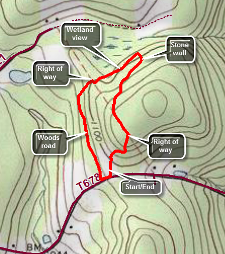
Cross the Delaware River from New York into Pennsylvania on the bridge at Cochecton. Almost immediately turn left on River Road. Follow River Road south along the river for a total of 6 miles. At 2.7 miles be sure to bear to the left to stay on River Road. Turn right on Macubbins Road and drive .7 miles to the parking area on the right. Walk through the opening in the rail fence next to the information kiosk. There aren't any visible markers but hug the edge of the field staying near the woods and you will pick up yellow paint blazes. The trail heads north through an evergreen forest gaining a little elevation. There can be a lot of debris and some blowdowns on the trail. You will quickly reach a power line right-of-way. The trail turns off the right-of-way and heads north through some more evergreen forest. Look to the left down the hill and you will see a trail which is for the return trip. At about half a mile into the hike there is a stone wall where the trail turns left and descends to the lower trail. The trail now runs along a wetland and heads southwest through some mixed softwood and hard wood forest until at .75 miles it turns south. The trail now follows a woods road which is open and ease to follow. Soon you will see the parking area up a hill on the left. There aren't many blazes to guide you so walk out to the road, turn left and then almost immediately left again into the parking area.
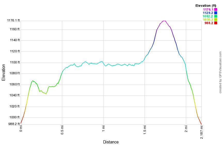
 (The image at the left shows the profile of the counterclockwise loop hiking route. Remember that all vertical profiles are relative!)
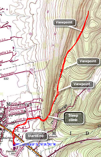
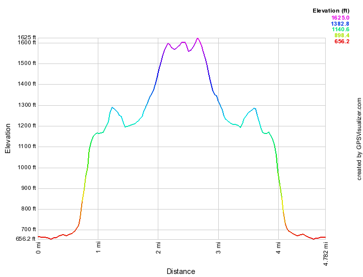
Delaware Water Gap: Mount Minsi
| Quick Look | ||||
|---|---|---|---|---|
| Difficulty | Round trip | Total climb | Internet Maps | |
| 4.51 mi. | 1139 ft. | AllTrails | ||
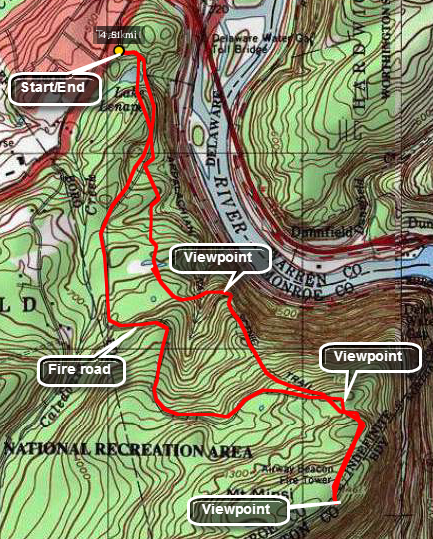
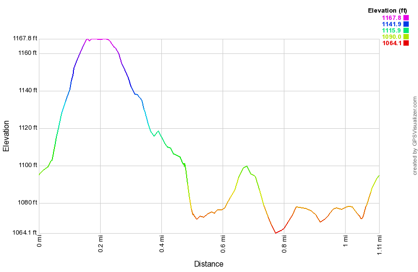
From Main Street (Route 611) in Delaware Water Gap, Pennsylvania turn south on Mountain Road. Drive up the hill and watch for Lake Road on your left. Drive in and park in the lot to been the hike. Watch for the white blazes of the Appalachian Trail which will take you to the summit. You will pass by Lenape Lake on your right as the trail slowly ascends through the forest. The trail is rocky at times but not very steep. After about 1.2 miles the trail turns and starts a steeper ascent. There is a nice viewpoint here down to the river and over to Mount Tammany on the New Jersey side. As you continue to climb another viewpoint is evident at 1.8 miles. Since you are higher here, the views are generally better. The next .25 miles gets you to the relatively flat top of the mountain. Continue your walk passing a small building in the area where you can see the steps to a fire tower. The trail goes near the edge of the cliffs and side trails lead nearer the edge. Walk to the viewpoints to get good views south on the Delaware River. Turn back to start down the mountain and walkabout .45 miles from the summit. Bear left on the Mt. Minsi Fire Road. The road is not an official hiking trail but is very obvious and gives a different route down the mountain. Around 2 miles from the top Table Rock will be on your right. This large, flat rock gives another viewpoint but is no better than the ones you have already experienced. The fire road will intersect the AT just short of Lenape Lake and you can follow the trail back to the parking area.
 (The image below shows the profile of the hike. Remember that all vertical profiles are
relative!)
(The image below shows the profile of the hike. Remember that all vertical profiles are
relative!)
Enfield Glen: Robert Treman State Park (NY)
| Quick Look | ||||
|---|---|---|---|---|
| Difficulty | Round trip | Total climb | Internet Maps | |
| 5.0 mi. | 1470 ft. | AllTrails | ||
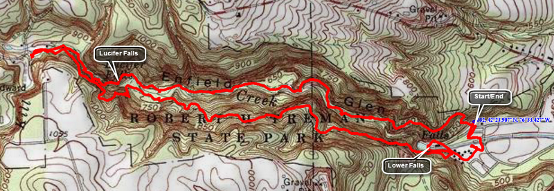
Head south on Route 13 from Ithaca, New York. Watch for signs for Buttermilk Falls State Park. Drive another 2 miles south and watch for signs for Robert Treman State Park and Park Lane. Park in the main parking area to begin the hike. The trails here parallel the glen and can be done in either direction. From the parking area head north to get on the trail that runs along the north rim of the glen. The first part of the hike has a steep ascent to the gorge rim and does not have many points of interest for over a half mile! Enfield Glen is not as developed as some other parks which means there are fewer people but also that the trails are more rugged with fewer defined viewpoints. Along the way you may be able to walk down to the stream bed and photograph some of the numerous small falls and rapids on the stream. Some places you should use your better judgment and stay on the trail as trying to get to the stream bed is dangerous! After a variety of falls and rock formations you will pass a bridge that crosses to the rim trail on the south side of the glen. Bypass this bridge to continue on to the main attraction, Lucifer Falls. Continue to limb up the path and various stairs toward the head of the glen. You will soon be walking next to a railing and a high rock wall. As you round a corner, Lucifer Falls comes into view. It is truly impressive even with low water levels and has an impressive drop. After taking in the view, walk passed this viewing area and another falls will come into view. Around another corner is a stone bridge which leads to the path on the other side of the stream. Beneath the bridge is a narrow slot which channels water into another falls. You will eventually arrive at the upper parking area where you can turn around and head back along the south rim. Before turning around you can visit an old mill and the falls that powered it. Head back to the beginning of the rim trail and climb UP to the south rim of the gorge. The trail flattens at the top but still has its downs and ups. In one place the trail drops down an impressive set of stone steps to the level of the stream. It follows the stream briefly before climbing back up to the rim. There are several viewpoints along the way with one offering a nice view down to Lucifer Falls. Near the end of the trail you can see down to the gorge and the Lower Falls. There is a swimming area for the park which sort of ruins the appearance of the falls. Below the Lower Falls a small dam holds back some water to form a pool for swimming. The gorge below this is not as high as further up but has some nice features. On the other side is some artificial stonework and a stone building. Return to the main path and follow it through an area where there are some cabins. To cross the stream there is a walkway for hikers but cars have to drive through several inches of water and ford the stream to cross!
 (The image at the left shows the profile of the out and back hiking route. Remember that all vertical profiles are relative!)
Falls Creek
| Quick Look | ||||
|---|---|---|---|---|
| Difficulty | Round trip | Total climb | Internet Maps | |
| 2.3 mi. | 765 ft. | AllTrails | ||
This hike is all bushwhack with no defined trails and few paths. It follows a creek through a gorge that is beautiful but can be dangerous. Although the hike is just over 2 miles it can take between 2 and 4 hours to complete! It requires scrambling over large rocks and tree stumps, crossing the stream several times and climbing up and down steep banks. Choosing the right water level can be tricky. Too much water makes hiking up the creek bed dangerous and tricky but too little water means the falls are not interesting. Take State Route 17 west from Binghamton to Waverley. At Waverley head south on State Route 220 through Towanda to Monroeton. Turned west on Route 414 to a small town called Powell. Turn left or south on Brocktown Road. Crossed two bridges and turn right onto Weston Road along Schrader Creek on your right. When the road forks, stay to the right. Cross the first narrow cement bridge and KEEP going to the second narrow cement bridge. It is a total of about 6.1 miles from the turn onto Weston/Schrader Creek Road. You will be in State Game Lands 36. Park on the right just before the bridge.
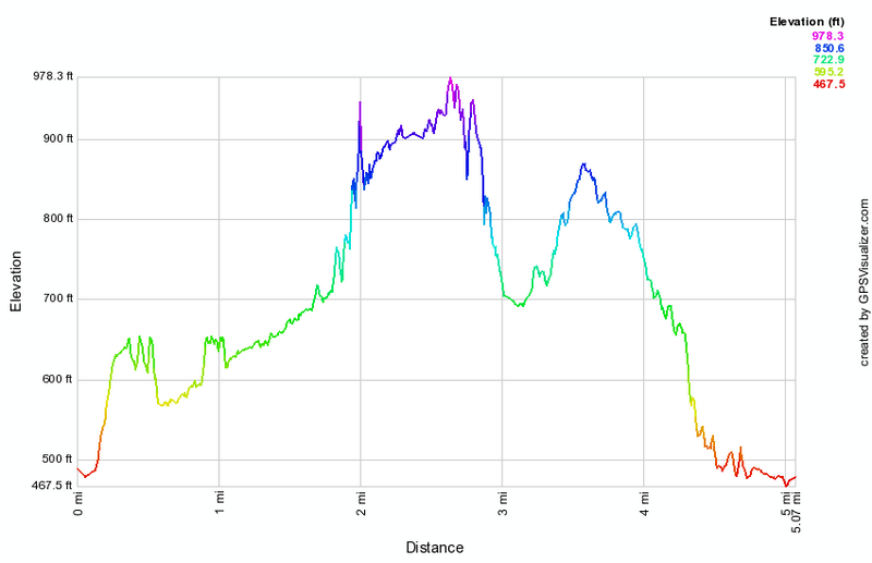
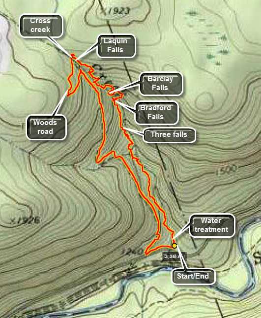
The water in Falls Creek drains from a plateau with an elevation of just under 2000 feet. The elevation of the parking area is about 1200 feet. In 1812 coal was discovered on top of the plateau. By 1856 the coal was being commercially mined and the town of Barclay was well-established on the plateau. After the coal ran out, the area became a center for logging and tanning. Most of the large hemlock forests were removed to feed this industry centered at the town of Laquin on Schrader Creek. Due to all this industry the waters of Falls Creek like many in the area are highly acidic. To counteract the acidity the state has built a water treatment facility on the creek just before the water flows into Schrader Creek. A dam diverts water through a cistern filled with limestone. The water turns a device that grinds the limestone which then dissolves in the water to neutralize the acid. The rocks in the upper part of the creek have a distinctive orange tint from the acid but those in the lower part show almost no discoloration. To hike simply head up the creek. Walk in the creek bed or on the left or right banks as you see fit. There are a few small rapids and then some falls with drops of six to twelve feet. At about .55 miles there are three small but pretty water falls in a row. Just passed the third falls you will begin to hear and then catch a glimpse of Bradford Falls. Bradford Falls is ENORMOUS compared to the ones below it! It is at least 70 feet tall. The water drops over the edge into a pool and the falls is bordered by the high stone walls of an impressive gorge. Work your way up the creek bed and you may be able to stand at the base of the falls. The next challenge is how to get out of the gorge to continue hiking upstream. Walk back down the stream until you see a spot where you can work your way up the right bank (looking upstream). Any route will be a STEEP climb up a slippery bank. You can use some of the trees to pull yourself up. Walk along the high ground briefly before descending back to the creek. Just above Bradford Falls is Barclay Falls. This waterfall is not as high as the one below but has a higher volume of water or at least a tighter chute. Climb back up to the higher ground and get ready for another descent to an area above a series of cascades and chutes on the creek below. This area has a steep bank and there may be no safe way to get down to the creek bed. Climb back up the bank and walk the high ground before starting to work your way down a steep bank toward another cascade. Once you make it down the steep bank there is a more level area. There is a ten foot cascade in this area. Walk along a little path along the creek and you will catch a glimpse of another falls. At Laquin Falls the stream passes over a receding ledge and splits to form at least two streams of water. The flow is not great as it is high on the creek but the falls is interesting. The stream is almost flat at this point with a greatly reduced volume of water. You will be at 1850 feet and near the top of the plateau. This is the end of the hike up the stream. Cross the creek here and walk along the high bank on the other side until you find a woods road. Follow the road downstream as it parallels the creek. The road becomes more defined as it descends. When it meets Schrader Creek Road turn left and walk across the bridge to the parking area.
 (The image at the left shows the profile of the hike. Remember that all vertical profiles are relative!)
Fillmore Glen
| Quick Look | ||||
|---|---|---|---|---|
| Difficulty | Round trip | Total climb | Internet Maps | |
| 5.0 mi. | 1650 ft. | AllTrails | ||
Fillmore Glen State Park is located in Moravia, NY on Route 38. The glen has many interesting geological features and historical significance. The park is named after the 13th President of the United States, Millard Fillmore, who was born in a small cabin about 5 miles from the park. A replica cabin on the grounds of the park represents the original cabin. Three main trails take hike through the gorge and along the north and south rims. Fillmore Glen is reminiscent of Watkins Glen, Enfield Glen and others but is less visited. The stream that now flows throw the glen is listed as intermittent and a visit may be more interesting when the water level is high.
As you enter the park, be sure to pick up a map that shows the various features and hiking trails. Park in the lot in front of the visitors center which has indoor picnic table and restrooms. To begin your hike walk to the right of the building toward the swimming area. There is a bridge upstream from the hiking area with signs on the near side directing you to the various trails. Turn right and walk up a long set of old stone steps. At the top of the steps, notice the very large oak tree to the left of the trail. The trail is flat for a short distance and the descends some steps to get nearer to the stream bed. At the bottom of the steps look straight ahead to see the "Cowsheds". Here the less resistant shale has been eroded away leaving the more resistant limestone above it. As you walk along the trail you will see several small water falls. The trail crosses and recrosses the stream on eight different bridges. At one point another stream enters the glen on the left side and pours down over the limestone into the main stream. This stream, like the main stream in the glen, is intermittent. Keep an eye on the stream bed and notice that in several places it is broken into large blocks. As of July 4, 2019, the Gorge Trail is closed at bridge 7 as the trail beyond that is impassable. Repairs are underway. The complete Gorge trail is about 1.5 miles. Turn around at bridge 7 and walk back to the steps that lead up to the junction of the Gorge Trail and South Rim Trail. Walk straight ahead and then turn left up the South Rim Trail. The initial part of the trail ascends at a 13% grade but this last for only about a quarter of a mile at which point the trail levels some. There is not very much to see along this trail until just before the descent to the gorge. Watch for a small "detour" on your left that takes you to a bridge and a viewpoint. The viewpoint is better when there are no leaves on the trees. To the right of the viewpoint is "The Pinnacle" where a vertical piece of rock is pulling away from the walls of the glen. Continue on the trail turning left when the blazes indicate. Walk down hill to bridge 8 and notice the lean-to on the left side of the trail. Cross the bridge and follow the red-blazed North Rim Trail. Over .2 miles the trail gains about 150 feet on a 14% grade. At the top of the climb there is another bench. Turn left to return to the car as the trail meanders some along the rim of the glen. It gains a little elevation in some spots but is primarily downhill. At one point the trail meets a small stream that had gut a gorge of its own which is perpendicular to the main glen. Walk upstream for a short distance to a bridge to cross this stream. This is the stream that you may have seen entering the main glen from the Gorge Trail. Continued on the trail and as you neared the end of the trail you will some to a series of steps which are wooden boxes filled with dirt and gravel. The wooden construction may not last as long as stone but they are much smoother and better looking. Descended the steps to the swimming area. Turned right and walk across a small lawn bearing slightly left to a foot bridge across the stream. Next to the foot bridge is a ford across the stream for cars to cross from one side of the park to the other. From hear walk back to your car. If you want, visit the cabin just to the left of the visitors center.
 (The image at the left shows the profile of the hike. Remember that all vertical profiles are relative!)
Heberly Run: Waterfall Bushwhack
| Quick Look | ||||
|---|---|---|---|---|
| Difficulty | Round trip | Total climb | Internet Maps | |
| 4.6 mi | 688 ft | AllTrails | ||
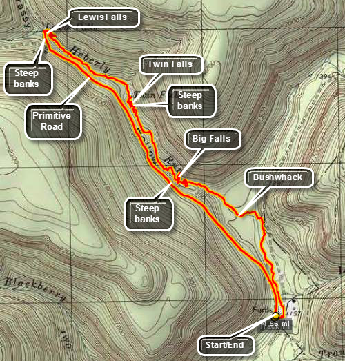
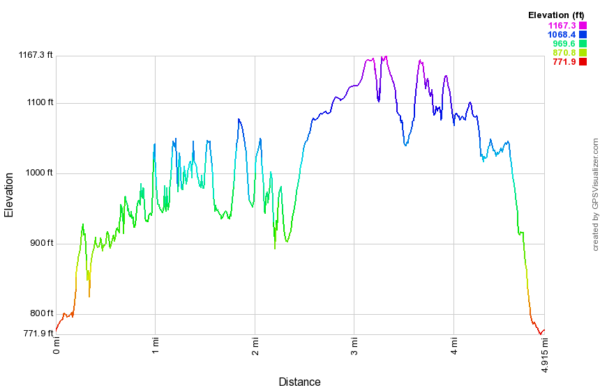
From Route 118 turn north onto Central Road. In Center take a right onto Jamison City Road. in Jameson City continue straight ahead on T720 to Sate Game Lands #13. Park in the parking area at the end of the road where you can go no further. This hike is a bushwhack up Herberly Run to three different waterfalls. The waterfalls are more interesting after a heavy rain but this makes them harder to access.
To begin the hike walk over to the stream and start walk along the far bank or in the stream bed itself. Keep working upstream for about a mile when you will be in the area of Big Falls. Since you are probably below the falls at this point, you will have to work your way up a steep embankment to continue the hike. A path exists on the left bank looking upstream but it is slippery even when not very wet. Continue to walk up the left bank until around 1.9 miles when Twin Falls will appear. This falls is smaller than Big Falls but is pretty in its own right. Once you are done inspecting these falls try climbing out of the gorge on the right bank. This will take you to the upper drop of Twin Falls where you may be able to walk or wade across to the right bank and access the path along the left bank above the falls. At around 2.65 miles Lewis Falls should come into view. The gorge at Lewis Falls is deeper than at the other two falls and the banks are impossible to scale. Walk back downstream until you can work your way out of the gorge preferably on the right side. From here you can walk to the top of Lewis Falls. There is a path that follows Herberly Run and then Shanty Run until it cuts across the plateau and comes back down. The path is indistinct and not well marked! Cross the stream above Lewis Falls and walk out to Grassy Hollow Road. This is a grass and dirt road that the Game Commission opens during hunting season. It makes the walk back to the car fairly easy. Along the way you can hear Heberly Run and catch glimpses of the water.
 (The image at the left shows the profile of the hike. Remember that all vertical profiles are relative!)
John Boyd Thacher State Park
| Quick Look | ||||
|---|---|---|---|---|
| Difficulty | Round trip | Total climb | Internet Maps | |
| 6.3 mi. | 1008 ft. | AllTrails | ||
 The main hiking attraction in the park is the Indian Ladder Trail along the Helderberg Escarpment.
This trail extends around the rim of the escarpment and descends into the gorge below the rim.
Other trails run throughout the park. The Long Path runs through one section. Most of these
trails are wide and well-maintained and relatively flat. An overlook area allows motorists
to park their cars and take in the beauty of the escarpment and the gorge. This area is a
favorite of "birders" since eagles and hawks frequent the area to ride the updrafts. The park
contains the Helderberg Escarpment which has two deposits of Devonian limestone. It is rich in
fossils from a shallow see that covered this area during that period. This escarpment is the one
pictured in the movie "Last of the Mohicans".
The main hiking attraction in the park is the Indian Ladder Trail along the Helderberg Escarpment.
This trail extends around the rim of the escarpment and descends into the gorge below the rim.
Other trails run throughout the park. The Long Path runs through one section. Most of these
trails are wide and well-maintained and relatively flat. An overlook area allows motorists
to park their cars and take in the beauty of the escarpment and the gorge. This area is a
favorite of "birders" since eagles and hawks frequent the area to ride the updrafts. The park
contains the Helderberg Escarpment which has two deposits of Devonian limestone. It is rich in
fossils from a shallow see that covered this area during that period. This escarpment is the one
pictured in the movie "Last of the Mohicans".
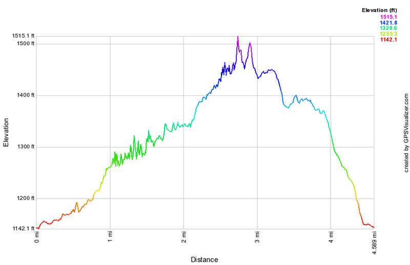
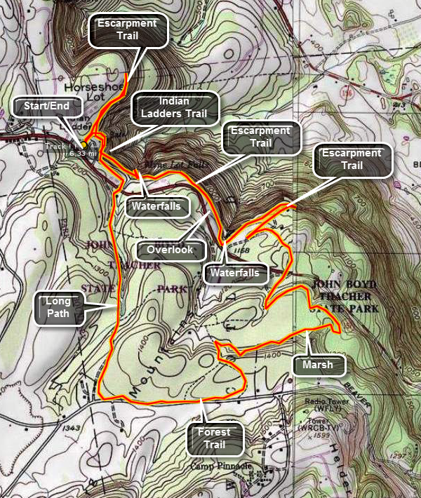
Start at the main parking lot at the park and find the Indian Ladder Trail. Descend the steps into the gorge. A fenced path runs along the limestone cliffs. Cracks are obvious in the limestone layers. Areas where the rock has been eroded away by water are clear. Small caves and underground streams riddle the rock face. Two different waterfalls cascade off the escarpment onto the trail below. Walk behind the falls but be careful since the limestone can be VERY slippery when wet. One area of the trail is almost obscured by overhanging rock. Climb out of the gorge to the escarpment rim. The trail continues along the rim in both directions. From the rim the views of the surrounding countryside and the other rim of the escarpment are magnificent! To extend the distance of the hike, cross over the main park road when you come out of the gorge and look for the forest trail. This trail start out by heading south but turns west until it intersects the Long Path. Turn right on the Long Path and continue north to the area of the gatehouse. Cross the main park road to walk back to the car.
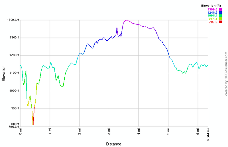 (The image at the left shows the profile of the hike. Remember that all vertical profiles are
relative!)
(The image at the left shows the profile of the hike. Remember that all vertical profiles are
relative!)
John Boyd Thacher State Park Escarpment
| Quick Look | ||||
|---|---|---|---|---|
| Difficulty | Round trip | Total climb | Internet Maps | |
| 4.6 mi. | 550 ft. | AllTrails | ||
 The main hiking attraction in the park is the Indian Ladder Trail along the Helderberg Escarpment.
This trail extends around the rim of the escarpment and descends into the gorge below the rim.
Other trails run throughout the park. The Long Path runs through one section. Most of these
trails are wide and well-maintained and relatively flat. An overlook area allows motorists
to park their cars and take in the beauty of the escarpment and the gorge. This area is a
favorite of "birders" since eagles and hawks frequent the area to ride the updrafts. The park
contains the Helderberg Escarpment which has two deposits of Devonian limestone. It is rich in
fossils from a shallow see that covered this area during that period. This escarpment is the one
pictured in the movie "Last of the Mohicans".
The main hiking attraction in the park is the Indian Ladder Trail along the Helderberg Escarpment.
This trail extends around the rim of the escarpment and descends into the gorge below the rim.
Other trails run throughout the park. The Long Path runs through one section. Most of these
trails are wide and well-maintained and relatively flat. An overlook area allows motorists
to park their cars and take in the beauty of the escarpment and the gorge. This area is a
favorite of "birders" since eagles and hawks frequent the area to ride the updrafts. The park
contains the Helderberg Escarpment which has two deposits of Devonian limestone. It is rich in
fossils from a shallow see that covered this area during that period. This escarpment is the one
pictured in the movie "Last of the Mohicans".
Start at the main parking lot at the park and find the Indian Ladder Trail. Descend the steps into the gorge. A fenced path runs along the limestone cliffs. Cracks are obvious in the limestone layers. Areas where the rock has been eroded away by water are clear. Small caves and underground streams riddle the rock face. Two different waterfalls cascade off the escarpment onto the trail below. Walk behind the falls but be careful since the limestone can be VERY slippery when wet. One area of the trail is almost obscured by overhanging rock. Climb out of the gorge to the escarpment rim. The trail continues along the rim in both directions. From the rim the views of the surrounding countryside and the other rim of the escarpment are magnificent! Continue the hike by turning left at the top of the stairs and following the trail along the escarpment. After a short walk, you will come to the scenic overlook which had a nice view north to Albany. At the end of the parking area walk along the edge of the woods and the pick up the trail along the escarpment again. As you walk along the escarpment you can see where you have been and where you were going! Eventually you will run out of fence and trail in pine forest. The trail ends at a sheer dropoff that gives a nice view of some stone blocks separating from the main cliff. You will be at about 1.7 miles. Head back the way you came. AT the Indian Ladder Trail, walk across the top of the escarpment to where you start down to the Indian Ladder Trail. Take the trail to the left that continues in the opposite direction along the escarpment. This trail has a few viewpoints that look down at the Indian Ladder Trail and some that look out over the valley toward Albany. Some of the views were the same as from the other end of the escarpment but at a different angle and with different lighting. Continue to follow the trail along the fence until at about 3.8 miles it starts to drop down a little. You will emerge from the woods near the Hailes Cave picnic area. Walk up to Hailes Cave Road and turn left to walk back toward the car.
 (The image at the left shows the profile of the hike. Remember that all vertical profiles are relative!)
Lenape Ridge Trail
| Quick Look | ||||
|---|---|---|---|---|
| Difficulty | Round trip | Total climb | Internet Maps | |
| 7.1 mi. | 1502 ft. | AllTrails | ||
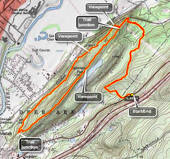 The trailhead is on Route 6 north just outside Port Jervis. There is a pulloff going up the hill on the right hand side by the Town of Deerpark sign. If you go as far as the power lines you have gone too far. Walk across the road and look for three red rectangles on a tree for the beginning of the Trail. The trail enters the woods and quickly connects to a woods road. There Rae many roads and informal paths in the area so be careful to follow the red trail markers. At .4 miles the trail abruptly makes a 90 degree turn northeast. The trail makes another 90 degree turn to the northwest at 1.2 miles and then starts to ascend to the ridge. At 1.6 miles there is a lookout to the north and wet and down into the Conrail cut through rocks. For the next 1.9 miles the trail follows the ridge line and dips and rises and some impressive rock formations. The red Minisink Trail ends at this point at a junction with the white Lenape Ridge Trail. Turn left on the white trail to hike back along the southeastern side of the ridge. The trail begins to climb to the highest point on the ridge at 4.2 miles and some nice viewpoints to the south and east are found here. Another lookout is at 4.5 miles above Heinlein Pond. From here the tower at High Point is clearly visible. The trail now begins a long descent off the ridge until at 5.3 miles it ends at the red Minisink Trail. Turn right here and follow the trail back to where your car is parked.
(The map on the right shows the parking area and the hiking route in an out and back and anticlockwise direction.)
 (The image at the left shows the profile of the hike. Remember that all vertical profiles are relative!)
Loyalsock Trail: Smith's Knob
| Quick Look | ||||
|---|---|---|---|---|
| Difficulty | Round trip | Total climb | Internet Maps | |
| 4.7 mi. | 1482 ft. | AllTrails | ||
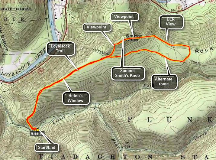 The Loyalsock Trail is a 59.3 mile trail in north central Pennsylvania in Lycoming and Sullivan counties . It stretching from the western trailhead just north of Montoursville to the eastern trailhead just north of LaPorte. It is well maintained by the Alpine Club Of Williamsport and is well marked with a distinctive yellow LT on a red can lid. The trail passes through main different geological and ecological areas and each is as interesting as the next. The hike described here starts near the western trailhead and takes and out and back and loop route to Smith's Knob.
Get on Route 87 going north from Williamsport. At between 9 and 10 miles the trailhead for the start of the Loyalsock Trail will appear as a pulloff on Route 87. Just passed this pull off is Little Bear Creek Road on the right. Turn onto this road and in less than 1 mile you will see a sign on the left for the Loyalsock trail to Smith's Knob. Just passed the bridge to the maintenance barns and across from the ranger's house is a pull off for several cars. Park here and then walk back down the road to the sign. Turn right up the hill, sign in at the register and begin your hike.
The first part of this hike is a long uphill with only a few places to catch your breath. At about .7 miles there is a viewpoint called Helen's Window that exposes a long, straight section of Loyalsock Creek. The trail continues until about 1.6 miles when it turns right onto an old woods road. This continues for about .1 miles where the trail turns left and begins a steep assault on Smith's Knob. At this point an alternate route continues straight ahead and is marked with a red X on a yellow background.
After climbing the short but steep slope the trial turns right toward the top of Smith's Knob. Near the pond on the right is a view to the right of the trail. There is no real view from the top but continue to walk east on the trail. When the trail begins to descend walk off the trail toward the obvious viewpoint to the left. This lookout offers beautiful views up and down Loyalsock Creek. At this point you may return the way you came or continue on the trail to complete the loop.
The descent on the other side of Smith's Knob is steep and eroded with several switchbacks. A little further along the trail is another Lookout called the DER View. This lookout offers more views up and down Loyalsock Creek and Loyalsock Valley. Continue on the trail being sure to stay on the marked LT trail. Be on the lookout for the trail marked by the red X's. This will be a sharp right turn and may have a NO HORSES sign marking it. This alternate route is not as well traveled as the main trail. There are several blowdowns and the markings are spread out further. This trail meets a woods road and travels along it for a short distance. Soon the road turns left and the trail bears right. In only a short distance the trail leads back to the junction with the main trail where the main trail turned up Smith' Knob. Follow the main trail back to your car.
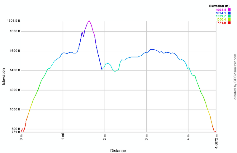 (The image at the left shows the profile of the hike. Remember that all vertical profiles are
relative!)
(The image at the left shows the profile of the hike. Remember that all vertical profiles are
relative!)
Loyalsock Trail: Sock Rock
| Quick Look | ||||
|---|---|---|---|---|
| Difficulty | Round trip | Total climb | Internet Maps | |
| 6.2 mi. | 1460 ft. | AllTrails | ||
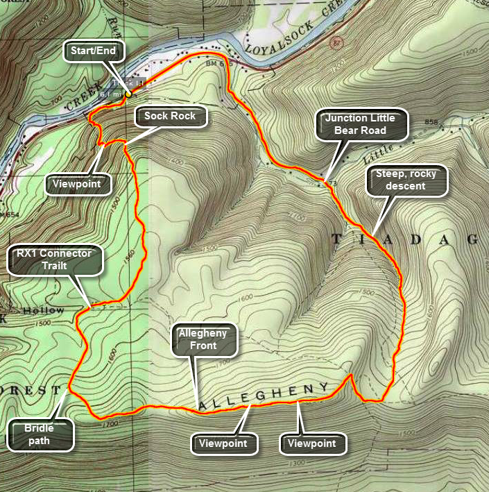 The Loyalsock Trail is a 59.3 mile trail in north central Pennsylvania in Lycoming and Sullivan counties . It stretches from the western trailhead just north of Montoursville to the eastern trailhead just north of LaPorte. It is well maintained by the Alpine Club Of Williamsport and is well marked with a distinctive red LT on a yellow plastic. Each mile from the beginning of the trail is also denoted at the closest markers. The trail passes through main different geological and ecological areas and each is as interesting as the next. The hike described here starts at the western trailhead and is a loop that includes the Allegheny Front. This first part of the trail takes in Sock Rock and has some great views especially when there are fewer leaves on the trees
Get on Route 87 going north from Williamsport. At between 8 and 9 miles the trailhead for the start of the Loyalsock Trail will appear as a pulloff on Route 87. Pull off and park here. The hike is STEEP right from the start giving you no chance to "warm up". After .4 miles the trail turns right as it meets an old woods road and there is a brief respite. Almost immediately the trail turns left off the road and up the ridge. A little further up the trail is a limited lookout on the right side of the trail. The overall .6 mile section to Sock Rock is an average of a 29% grade! There are some impressive ledges along the way but Sock Rock itself doesn't look much like a sock and there are no views! The trail turns right after Sock Rock but continues to climb steeply for another .25 miles. After the climb, the level part of the trail is welcome! At 1.55 miles the Red X-1 trail crosses. The Red X trails connect different parts of the Loyalsock Trail in different areas acting as shortcuts. There are eleven of them in all and can be interesting adventures in their own right. All, true to their name, are marked with red X's. Continue on the main trail and at 2 miles the Loyalsock Trail turns left. A woods road is to the right and straight ahead is a bridle path to allow horses access to the plateau. After this point the trail begins to climb some but it is hardly noticeable when compared to the initial climb. You are now walking west to east along the Allegheny Front. Looking for viewpoints which are few during the seasons when there are leaves on the trees. At about 2.9 miles there is a limited viewpoint. The trail is interesting in this area as it ascends and you will be walking very close to the edge of the Front. As you continue on another viewpoint, the best yet, opens up on a rock ledge with nice views to the south. A short path leads down to a lower rock shelf with an even better view. Be careful to watch for rattlesnakes sunning themselves on the rocks! They will rapidly vacate the area on your approach as long as you do not surprise them. From "Rattlesnake Rock" the trail begins to descend gently for about .5 miles until it takes a sharp left and heads down a rocky drainage. The hike down this part of the trail can be tricky as the rocks may be mossy, damp and slippery in places. Watch for some very tall and very straight trees along this route. These trees may not have be first growth but they are old. Loggers in this area harvested white pine for ship masts and when the white pines were done they turned to hemlocks. The hemlock bark was used for tanning and, many times, the rest of the tree lay unused. Over the next 1.2 miles the trail drops over 950 feet and the total drop from the highest point is over 1100 feet. The trail crosses Little Bear Road at the bottom of the descent. Turn left and start to walk back out to Route 87. The Loyalsock Trail continues on your left and goes up and over Smith's Knob. You can hike this loop using the Painter Run Trail on your return if you still have the time and energy. Walk .8 miles out to Route 87, turned left and walk .5 miles to the your car to complete the loop.
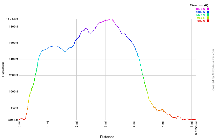 (The image at the left shows the profile of the hike. Remember that all vertical profiles are
relative!)
(The image at the left shows the profile of the hike. Remember that all vertical profiles are
relative!)
Mendon Ponds Park - East Esker Ridge Trail
| Quick Look | ||||
|---|---|---|---|---|
| Difficulty | Round trip | Total climb | Internet Maps | |
| 5.2 miles | 660 ft. | AllTrails | ||
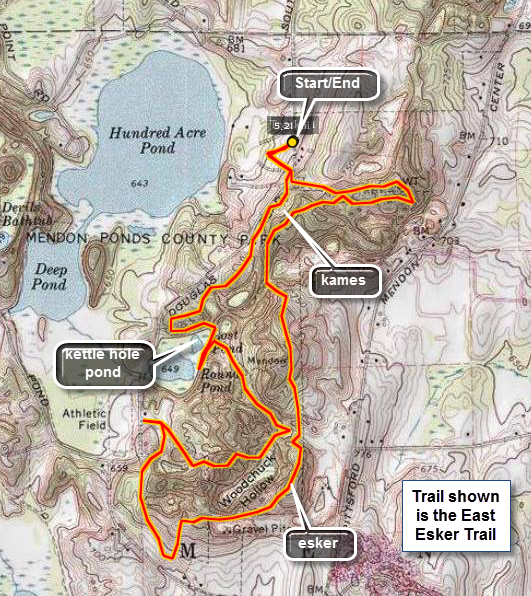
Mendon Ponds Park's unique complex of glacial features helped to make it a National Natural Historic Landmark in 1969. There is a 550 acre nature preserve, and 30 miles of self guided trails full of wildlife. At the northwestern end of the line of other glacial ponds and lakes near the kettle hole called the "Devil's Bathtub" in the park, there is a sphagnum moss peat bog, and the buildup of moss has created a floating island in the middle of the lake. Due to the acidity buildup and lack of decay caused by the sphagnum moss, the bog is home to a number of carnivorous plants, including sundew and pitcher plants. Like much of New York State the topography here was shaped by several different ice sheets that covered the area in the past. The Finger Lakes are some of the most prominent features but everywhere you look there are glacial formations if you know what to look for. Mendon Ponds has several esker ridges formed when glacial streams deposited sediment. It has at least two kettle lakes formed when large blocks of ice dropped off receding glaciers, formed indentations in the soil, melted and left ponds and lakes behind. There are several kame hills formed when unsorted deposits lying on the glacier were deposited in a "heap" as the glacier melted.
A map of the park describes the marked trails and some of the features you will find. None of the trails are difficult but some can be muddy since part of the park is a wetland. In addition to the marked trails there are MANY "informal" trails which can be misleading but most reconnected to the marked trail system at some point. A good choice to see a variety of glacial features is the East Esker Ridge Trail marked at 4.7 miles in length on the map.
Once in the Rochester/Rush area find Rt 65 or Clover Street. The entrance to the park is just south of I-90 and is well marked. Turn into the park on Canfield Road and proceed to the first four corners. Turn right here onto Douglas Road. Look for the Canfield Woods or Stewart signs. Canfield Woods is the first BIG parking area on you right just across from the park office. This is the best place to park and, by the way, entrance and parking are FREE! Walk back up the entrance and across the road to a chain link fence which is the start of the green East Esker Ridge Trail. You may notice a blue marking on a tree since part of the trail is shared with the North Meadow Trail. Turn right and start your walk along the trail as it roughly parallels Douglas Road.
You will find that as you walk a familiar theme develops. At times you will walk up onto esker ridges and walk along the tops with a dropoff on either side. Other areas of the trail are sited between ridges or up and over kame hills. Along the way you will see several different ponds and walk through both hardwood and evergreen forests. The highest point in the park (820 ft.)) is on the trail in the last quarter of the hike. Walk along the trail for about .25 miles and you will come out of the forest into an opening. Straight ahead are some rolling kame hills. Reenter the forest trail and continue walking over the rolling topography. At about .7 miles you will walk down a hill and along Round Pond. To the left is a high hill you might want to climb. The trail doesn't offer much of a view of the pond but just as you start back into the trees there is and informal trail that ascends an esker ridge on the right. Walk along this trail if you like to get some limited views down onto the pond.
Back on the main trail, hike .35 miles east between several ridges until the trail abruptly turns west. After .6 miles you will descend to Douglas Road at the Calvary Shelter. If you actually get to the shelter you have gone too far, so turn around and take your first right to stay on the trail as it continues .45 miles south to Pond road and the other major trailhead for this trail. The trail at this point has just taken you through some open fields and it turns quickly left to head first north and west. The trail gains some elevation here as it first ascends, descends and then climbs several ridges. Be on the lookout for a small spur trail to the right which leads to a wooden bench along the way. This bench offers a spot to relax and look out over the surrounding hills and valleys. Also watch for a small blue marker labeled 23 on your left. This is the highest spot in the park at 820 ft!
After 1.2 miles of walking along the ridge, you will descend and then ascend once again. The trail continues north but then starts to turn left until you are walking due east. On your left will be a large water tank and the trail will lead around it after about .75 miles. The trail now turns into a wide road paved with crushed gravel and leads directly back to the trailhead where you started after .3 miles.
Another interesting place to visit is the kettle hole called the Devil's Bathtub. From the parking area turn right on Douglas Road and continue south until the intersection with Pond Road. Turn right on Pond Road and watch for the Devil's Bathtub Parking area on the right. Drive up and park. When you get out of the car, notice the view to Deep Pond on your right. Find the sign that says "Devil's Bathtub" and head down the wooden stairs to this kettle pond. There is a wooden walkway along the edge of the pond but no real view down onto the pond to take it all in. The trails here are NOT well marked but you can head around the pond on the aqua trail and informal trials until you meet the light blue Grasslands Trail. If you stay on the aqua trail, it turns to the right away from the Devil's Bathtub and takes you along the shore of Deep Pond. Either walk is worthwhile.
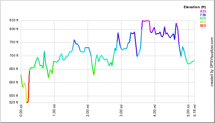 (The image at the left shows the profile of the hike. Remember that all vertical profiles are
relative! Although this profile looks menacing, the elevation gains are seldom more than 50 ft!)
(The image at the left shows the profile of the hike. Remember that all vertical profiles are
relative! Although this profile looks menacing, the elevation gains are seldom more than 50 ft!)
Middleburgh Cliffs
| Quick Look | ||||
|---|---|---|---|---|
| Difficulty | Round trip | Total climb | Internet Maps | |
| 4.8 mi. | 1220 ft. | AllTrails | ||
The area around Middleburgh is best known for Vroman's Nose and Thacher Park but the Middleburgh Cliffs also offer a nice view of the Schoharie Plain and Vroman's Nose itself.
In the village of Middleburgh turn south and east on Route 145 from Route 30. Within less than .5 miles watch for a school on your right. As long as school is not in session, you may park in the school lot. If school is in session, park legally on the street. Walk across Route 145 and slightly to the left look for Staub Lane. Turn left on Union Street and then right on Cliff Street. As you walk, you should notice the aqua blazes of the Long Path on telephone poles. Where Cliff Street ends the Long Path ascends a rather steep bank that is eroded. Climb up the bank and follow the Long Path as it makes a short but steep climb over the next .6 miles. After passing over and through some rocks, the trail descends some and then rises again. At about 2.2 miles the trail levels off at around 1600 feet. It follows the cliffs for some distance and you can walk as far as you like. All along the way there are views into and over the valley with some being better than others. Watch especially for views of Vroman's Nose. When you have had enough, turn around and retrace you path to the car.
 (The image below shows the profile of the loop hiking route. Remember that all vertical profiles are relative!)
Mongaup River Trail
| Quick Look | ||||
|---|---|---|---|---|
| Difficulty | Round trip | Total climb | Internet Maps | |
| 2.1 mi. | 130 ft. | AllTrails | ||
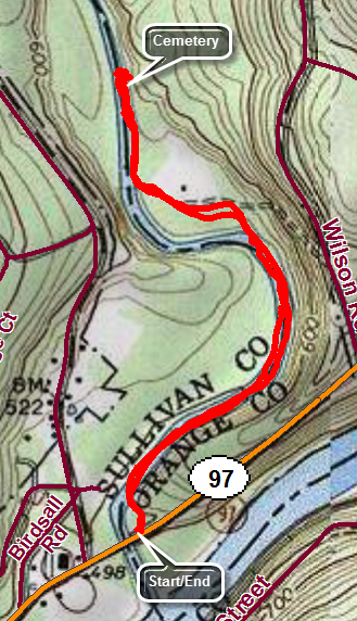
 Drive south on Route 55 toward Eldred. In Eldred turn left at the light on CR-32 (Proctor Road) and drive a little over 5 miles to Glen Spey. Turn right and then left on CR-31 (Upper Mongaup Road). Drive south a little over 5 miles to Route 97. Make a left, cross the bridge over the Mongaup River and make a quick left into the parking area. The trail leaves the right side of the parking area as a flat gravel path paralleling the river. The trail is easy to walk and easy to follow. IN a few places it splits to go around some bushes and then unites just after. You may want to drop down to the water's edge to get a view of the river. The trail remains easy to follow and relatively flat and well maintained for the entire length. Continue to the end of the trail where you will find an old cemetery to the right of the trail. The engraving on the stones is weathered and hard to read but one date is "1882". Turn around to walk back to your car the way you came.
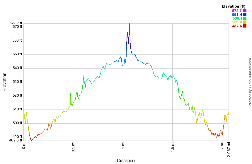
(The image at the left shows the profile of the hike. Remember that all vertical profiles are
relative!)
Drive south on Route 55 toward Eldred. In Eldred turn left at the light on CR-32 (Proctor Road) and drive a little over 5 miles to Glen Spey. Turn right and then left on CR-31 (Upper Mongaup Road). Drive south a little over 5 miles to Route 97. Make a left, cross the bridge over the Mongaup River and make a quick left into the parking area. The trail leaves the right side of the parking area as a flat gravel path paralleling the river. The trail is easy to walk and easy to follow. IN a few places it splits to go around some bushes and then unites just after. You may want to drop down to the water's edge to get a view of the river. The trail remains easy to follow and relatively flat and well maintained for the entire length. Continue to the end of the trail where you will find an old cemetery to the right of the trail. The engraving on the stones is weathered and hard to read but one date is "1882". Turn around to walk back to your car the way you came.
(The image at the left shows the profile of the hike. Remember that all vertical profiles are
relative!)
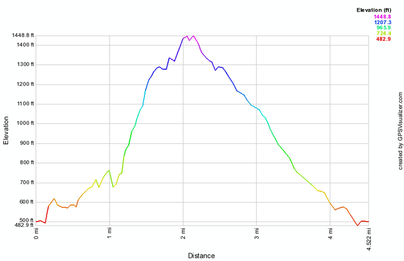
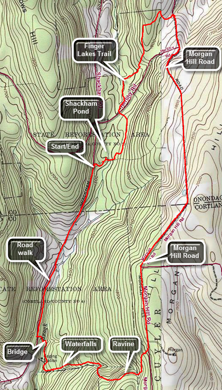
Morgan Hill (Big Loop)
| Quick Look | ||||
|---|---|---|---|---|
| Difficulty | Round trip | Total climb | Internet Maps | |
| 12.8 mi. | 2580 ft. | AllTrails | ||
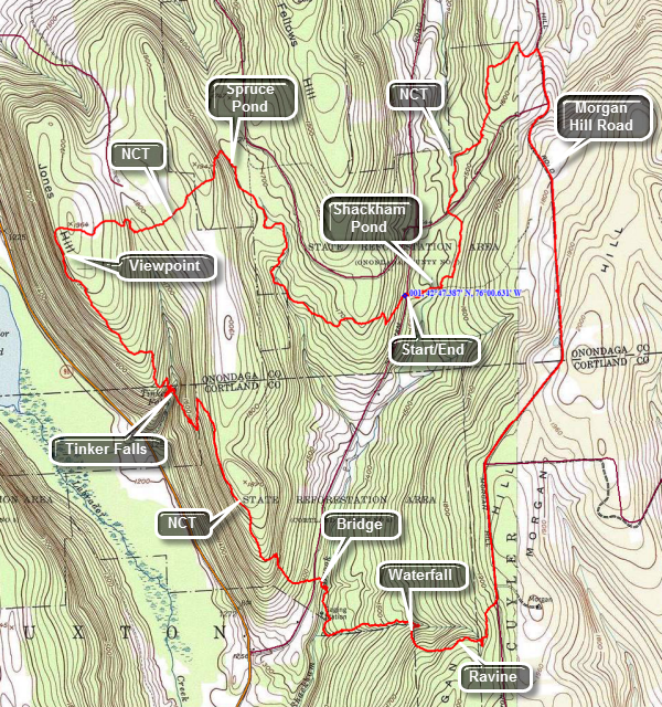
Morgan Hill State Forest sits in the upper northeast corner of Cortland County the lower southeast corner of Onondaga County. It has many miles of trails and woods roads to explore and is crossed by the North Country Trail. The trails are used for both hiking and mountain biking. The area also has several ponds and streams. The streams have some small cascades and one named waterfall, Tinker Falls. The best viewpoint is from Jones Hill. The area also is adjacent to Labrador Pond Unique Area.
From the south take I81 to exit 11. Take Route 13 north for about 10 miles to Route 91 in Truxton. Turned left and drive about 3.6 miles to Shackham Road. Turn right on Shackham Road in Morgan Hill State Forest ,and drive about 2 miles to a pulloff on the right side of the road. DO NOT park at the larger parking area just before this! The North Country National Scenic Trail stretches approximately 4,600 miles from Crown Point on Lake Champlain in eastern New York to Lake Sakakawea State Park in central North Dakota in the United States. Walk to the "beginning" of the trail on your side of the road and head east on the blue-blazed NCT. After only a short distance you will be on the shores of Shackham Pond. The pond is pretty and surrounded by both hardwood and softwood trees. Headed back to the main trail and within a few hundred feet pass across the top of the dam that creates the pond. Hike north through mostly hardwood forest and at about .7 miles you will cross a well-maintained dirt road and entered an evergreen forest. Stop at the trail register and sign in before continuing on the trail. The trail parallels a small stream for some time and may be wet and muddy in places. In this area the trail is almost flat with only a few bumps. Pass by several woods roads and at 1.9 miles the trail will again cross a road before entering the woods. At this point we turn right on the dirt road which becomes Morgan Hill Road. After a slight uphill walk of about .3 miles at 2.2 miles into the hike there is a gate across the road to permit only "seasonal access". Continue straight ahead and be prepared for a rather long walk on this isolated road. At 4.2 miles Eaton Hill Road comes in from the left and it should now be only a half mile or so until the NCT appears on the right at about 4.8 miles. Turn right into the forest and head almost due east along a tributary of Shackham Brook. Sections of the trail here can be VERY muddy. At 5.2 miles walk down the trail into a beautiful ravine. The trail crosses the brook here but you can walk a few hundred feet upstream to a small waterfall. Walk back to where the trail crosses the stream and negotiate the steep bank.
The trail almost immediately meets a woods road and follows it for some distance until the trail heads to the right and down. The trail starts to parallel to the brook and you may notice several small waterfalls. Continue to walk on the trail parallel to the brook until 6.1 miles where there is another nice waterfall off the trail to the left. Continue on the trail toward Shackham Road. A nice footbridge crosses the stream and the streambed here was solid rock. On the other side of the bridge the trail can be VERY wet. Crossed Shackham Road about 6.6 miles into the hike. Your car is only about 1.5 miles up the road but the best part of the hike is yet to come! After crossing the road the trail begins to climb through hardwood forest almost immediately. Over the next .6 miles the trail climbs about 450 feet which is one of the steepest parts of the trail up to this point. At the top of the climb the trail levels a bit as it runs along the shoulder of a hill on the right. After a short walk on relatively flat ground, begin a descent to Tinker Falls. There is one major switchback on the descent and the trail at the bottom is not well marked. Cross the stream above the falls and walk to the edge of the gorge to see the falls below. there is no safe path down to the base of the falls from the top but you can park on Route 91 and walk the short "nature trail" to the falls after completing the loop hike!
Finding the NCT blazes here can be a little problem. The trail comes down some steps on the east side, crosses the stream, goes a little more that 100 feet and then hooks back almost 180 degrees to climb the hill on the other side. Head up the trail. Over the next mile from the top of the falls you will ascend about 430 feet. The trail is never steep but the ascent is continuous. You will cross a dirt road at some point and the trail turns onto it at another. Eventually the trail dips to the right into the woods and leads to the viewpoint on Jones Hill at about 9.6 miles into the hike. The view from this outlook is spectacular! There is a valley below with a few hills and mountain in the distance. Labrador Pond is visible below. You still have about 3 miles to hike and after a short distance, the trail turns right and crosses the top of Jones Hill on private property. Over the next 1.2 miles the trail rolls a little with no major ascents or descents until the walk down to Spruce Pond at around 11 miles. There is a NCT kiosk at the outlet end of the pond.
The last 1.7 miles is mostly downhill with one little bump near the end. The first part of this section of the trail parallels a stream and may be wet and muddy. The very last few feet of the trail before the road can be a muddy quagmire but at least you are now back at your car. If you want to visit the base of Tinker Falls drive back down Shackham road to Route 91. Turn right and drive 1.2 miles north to the parking area for Tinker Falls. Park on the left side of the road in the large parking area. Walk across the road to the trail to the falls which is wide and "paved" with crushed stone. There are several benches along the stream. When you get to the end of the trail, walk up the stone of the streambed to the base of the falls. The amount of water going over the falls varies greatly and it is best to visit after a rainfall. There is even a trail that allows you to walk behind the falls. The round trip walk is about .6 miles
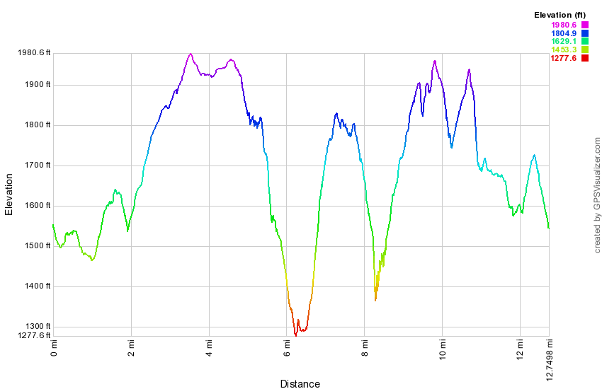 (The image below shows the profile of the loop hiking route. Remember that all vertical profiles are relative!)
Morgan Hill (East Loop)
| Quick Look | ||||
|---|---|---|---|---|
| Difficulty | Round trip | Total climb | Internet Maps | |
| 8.0 mi. | 1075 ft. | AllTrails | ||
Morgan Hill State Forest sits in the upper northeast corner of Cortland County the lower southeast corner of Onondaga County. It has many miles of trails and woods roads to explore and is crossed by the North Country Trail. The trails are used for both hiking and mountain biking. The area also has several ponds and streams. The streams have some small cascades and one named waterfall, Tinker Falls. The best viewpoint is from Jones Hill. The area also is adjacent to Labrador Pond Unique Area.
From the south take I81 to exit 11. Take Route 13 north for about 10 miles to Route 91 in Truxton. Turned left and drive about 3.6 miles to Shackham Road. Turn right on Shackham Road in Morgan Hill State Forest ,and drive about 2 miles to a pulloff on the right side of the road. DO NOT park at the larger parking area just before this! The North Country National Scenic Trail stretches approximately 4,600 miles from Crown Point on Lake Champlain in eastern New York to Lake Sakakawea State Park in central North Dakota in the United States. Walk to the "beginning" of the trail on your side of the road and head east on the blue-blazed NCT. After only a short distance you will be on the shores of Shackham Pond. The pond is pretty and surrounded by both hardwood and softwood trees. Headed back to the main trail and within a few hundred feet pass across the top of the dam that creates the pond. Hike north through mostly hardwood forest and at about .7 miles you will cross a well-maintained dirt road and entered an evergreen forest. Stop at the trail register and sign in before continuing on the trail. The trail parallels a small stream for some time and may be wet and muddy in places. In this area the trail is almost flat with only a few bumps. Pass by several woods roads and at 1.9 miles the trail will again cross a road before entering the woods. At this point we turn right on the dirt road which becomes Morgan Hill Road. After a slight uphill walk of about .3 miles at 2.2 miles into the hike there is a gate across the road to permit only "seasonal access". Continue straight ahead and be prepared for a rather long walk on this isolated road. At 4.2 miles Eaton Hill Road comes in from the left and it should now be only a half mile or so until the NCT appears on the right at about 4.8 miles. Turn right into the forest and head almost due east along a tributary of Shackham Brook. Sections of the trail here can be VERY muddy. At 5.2 miles walk down the trail into a beautiful ravine. The trail crosses the brook here but you can walk a few hundred feet upstream to a small waterfall. Walk back to where the trail crosses the stream and negotiate the steep bank. The trail almost immediately meets a woods road and follows it for some distance until the trail heads to the right and down. The trail starts to parallel to the brook and you may notice several small waterfalls. Continue to walk on the trail parallel to the brook until 6.1 miles where there is another nice waterfall off the trail to the left. Continue on the trail toward Shackham Road. A nice footbridge crosses the stream and the streambed here was solid rock. On the other side of the bridge the trail can be VERY wet. The trail meets Shackham Road at 6.6 miles into the hike. Turn right and hike 1.5 miles up the road back to your car. This walk is all a slight uphill.
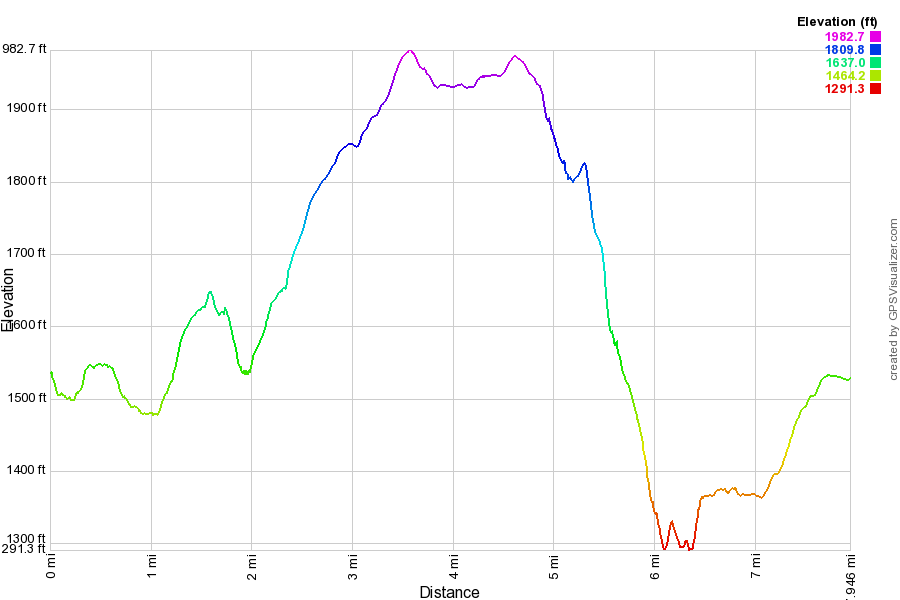 (The image below shows the profile of the loop hiking route. Remember that all vertical profiles are relative!)
Morgan Hill (Jones Hill Loop)
| Quick Look | ||||
|---|---|---|---|---|
| Difficulty | Round trip | Total climb | Internet Maps | |
| 8.0 mi. | 1535 ft. | AllTrails | ||
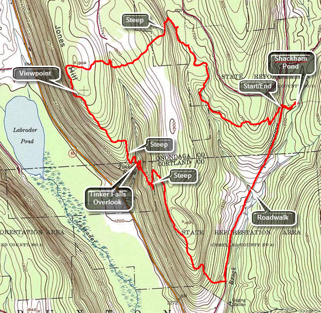
Morgan Hill State Forest sits in the upper northeast corner of Cortland County and the lower southeast corner of Onondaga County. It has many miles of trails and woods roads to explore and is crossed by the North Country Trail. The trails are used for both hiking and mountain biking. The area also has several ponds and streams. The streams have some small cascades and one named waterfall, Tinker Falls. The best viewpoint is from Jones Hill. The area also is adjacent to Labrador Pond Unique Area.
From the south take I81 to exit 11. Take Route 13 north for about 10 miles to Route 91 in Truxton. Turned left and drive about 3.6 miles to Shackham Road. Turn right on Shackham Road in Morgan Hill State Forest ,and drive about 2 miles to a pulloff on the right side of the road. DO NOT park at the larger parking area just before this! The North Country National Scenic Trail stretches approximately 4,600 miles from Crown Point on Lake Champlain in eastern New York to Lake Sakakawea State Park in central North Dakota in the United States.
Cross the road and hike up the trail which can be muddy at times heading toward the top of the first ridge. The first .4 miles is all uphill and gains a little over 150 feet. The trail in this area is pretty generic passing through mostly hardwoods and then some evergreens. Descend the other side of the hill and then walk along as the trail rolls a little. At 1.75 miles come to the shores of Spruce Pond with an earthen dam at one end. From the dam walk along the shore of the pond following the Onondaga Trail which is blazed in light blue and an orange trail that loops around the pond. The trails spilt near the head of the pond. Follow the blue trail and start one of the steepest ascents of the hike which is moderated by some switchbacks as it gains 220 feet in about .25 miles. At the top of the hill, start to descend again losing most of the elevation you gained and crossing a small stream. Much of the hike to this point has been parallel to one small creek or another. The turn and ascent changes your direction to WSW and begins a section of the trail which is on private land. The land is owned by a logging company that has granted permission for hikers to cross their property. Make another ascent to the top of the ridge that overlooks Labrador Pond. Pass over the top of Jones Hill and at 3.1 miles turned south to walk along the ridge. At 3.25 miles there is a viewpoint which looks out of Labrador Pond and the valley and hills below. The trail now follows the edge of the ridge while a dirt road also descends the hill. The trail winds round and crosses the road before joining it for the final descent. From 3.4 miles to 4.3 miles the trail descends toward Tinker Falls. At 3.9 miles the descent becomes steeper. There is a trail to the falls from a parking area on Route 91 which makes access to the base rather easy. In the past there was no way to hike between the top and bottom without following a treacherous and steep path covered in loose dirt and slippery leaves. The Finger Lakes Trail Conference worked on a project to install stone steps on both sides of the falls to allow hikes to travel between the bottom and the top. From the top of the falls walk upstream to the wooden stairs that start the long climb to the top of the next ridge. The .7 mile ascent to the 5.1 mile mark ascends almost 400 feet but has several switchbacks. The switchbacks do moderate the climb but also make the trip longer. Once at the top, begin the downhill hike to Shackham Road. Turn left at the road and begin to walk the road back to your car at the upper parking area. It is about 1.5 miles back to the upper trailhead. As you near the car, turn right on the Onanadoga Trail for a short .15 mile hike to Shackham Pond. Stop on the dam for the best views. At the near end of the dam are some headstones that are all from one family including one for an infant who lived only 18 days. The dates are from the early 18th century. Continue back the way you came to your car.
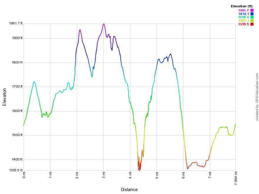 (The image below shows the profile of the loop hiking route. Remember that all vertical profiles are relative!)
Mount Greylock: Hopper Trail
| Quick Look | ||||
|---|---|---|---|---|
| Difficulty | Round trip | Total climb | Internet Maps | |
| 8.5 mi. | 2513 ft. | AllTrails | ||
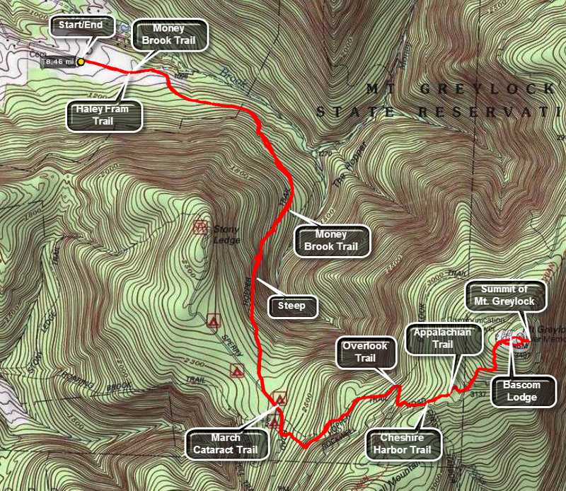
From Sate Route 7 in Massachusetts take route 43 eat for 2.3 miles. In New Hope turn right on Hopper Road. At 1.4 miles the road splits in a Y with Hopper Road going to the left. Stay left on Hopper Road and drive to the dead end. Park in the parking area at the end of Hopper Road.
The very first part of the trail is an old farm road . This part is flat and the Haley Farm trail leaves to the right and then the Money Brook Trail branches to the left. Stay on the Hopper Trail marked mostly by fading blue blazes. The first mile of the trail nearly parallels the contour lines but constantly and gradually gains elevation. The trail is rooted and rocky in places. Some very large blowdowns have simply been left in place and "steps" have been cut through them. Around 1 mile the trail turns more to the south and starts to gain elevation toward the Greylock ridge. Over the next mile there is a gain of over 900 vertical feet. There are no rock scrambles or anything really steep but the climb is relentless. At 2.0 miles the trail levels some and meets Sperry Road at 2.3 miles. Turn left to hike up Sperry Road passing the campground office. Turn left at 2.6 miles to get back on the Hopper Trail. This part of the trail started innocently enough but then begins to gain elevation again quickly. At about 3.3 miles the Overlook Trail branches to the left. Stay on the Hopper Trail which begins to roughly parallel Rockwell Road. At 3.8 miles cross Rockwell and North Adams Roads and stay on the trail which will now have white markings to indicate that the Appalachian Trail had joined the Hopper Trail. From here it is only about .3 miles to the summit. There were a few more short sections to climb and just before the radio tower is Gore Pond, the highest body of water in the state. After this the trail passes a radio tower and crosses the road. A large stone is inscribed with a quote from Thoreau. Cross the road where there is a metal sculpture that shows all of the Greylock Reservation and the hiking trails. Behind this on the very summit is the War Memorial Tower and to the right is Bascom Lodge. A new road allows people to drive to the summit so the area may be crowded. Walk passed the tower and to the viewpoints on the other side. There are nice views to the east and if you walk down the slope you can get better angles for pictures. The views from the back of Bascom Lodge are also nice. When you have exhausted you exploration of the summit, return the way you came.
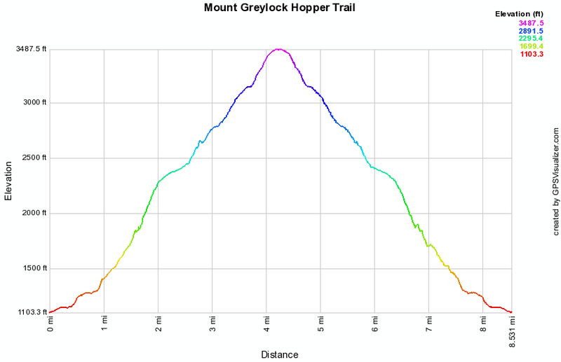 (The image at the left shows the profile of the hike. Remember that all vertical profiles are relative!)
Mount Greylock: Jones Nose
| Quick Look | ||||
|---|---|---|---|---|
| Difficulty | Round trip | Total climb | Internet Maps | |
| 5.9 mi. | 1332 ft. | AllTrails | ||
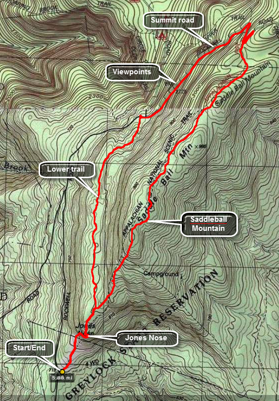
Take Route 7 south toward Pittsfield from Williamstown. At 13.3 miles from Williamstown in Pittsfield turn left on North Main Street. In less than a mile turn right on Quarry Road and follow the signs for "State Reservation". In .4 miles turn left on Rockwell Road passing the Visitor's Center in another .6 miles. Drive passed the Center and up Rockwell Road. At 4.3 miles watch for a parking area on the right for Jones Nose.
Get on the blue Jones Trail and start to climb through open fields with stunning views to the south down the mountain into the valley and over the hills beyond. The trail soon enters some brush and then trees which obscure the view. In a little less than .5 miles the trail became less steep and at .6 miles the trail forks with the CCC Dynamite Trail heading left and the Jones Nose Trail going right. Bear right and start a steep climb up to the AT which runs across Saddleball Mountain. At about .8 miles a spur trail labeled "view of the Catskills" turns to the left. Walk out to a rock outcrop to take some pictures before returning to the main trail. Just passed 1 mile the Jones Nose Trail ends. Turned left on the AT and head north. The AT runs across the Saddleball Mountain Ridge although not always on top. After about 1.6 miles, you will be back at Rockwell Road. Walk the .9 miles down Rockwell Road to Sperry Road and pick up the CCC Dynamite Trail on the left to get back to Jones Nose. As you walk down Rockwell Road you will find several nice viewpoints to the west. The CCC Dynamite Trail stretches about 1.35 miles from Rockwell Road to Jones Nose and is slightly uphill all the way. This trail can be wet and has several stretches of functional puncheons and plentiful nettles. Turn right on the Jones Nose Trail and walk back to the car.
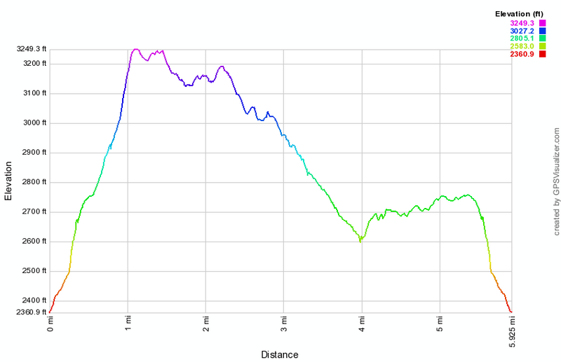 (The image below shows the profile of the hike. Remember that all vertical profiles are relative!)
Mount Greylock: Loop
| Quick Look | ||||
|---|---|---|---|---|
| Difficulty | Round trip | Total climb | Internet Maps | |
| 12.8 mi. | 4666 ft. | AllTrails | ||
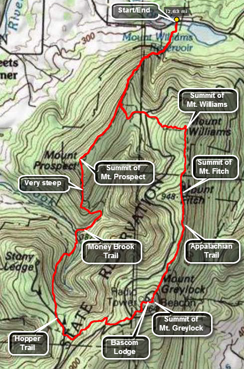
Turn south on Luce Road off Route 2 in Williamstown, MA. Luce Road makes a left and become Pattison Road. Park near the water treatment plant on either side of the road in pulloffs for AT hiking.
Pick up the white blazes of the Appalachian Trail as it heads south toward the Greylock Massif. Walking into the woods the trail is flat for a few hundred feet. After that, the it starts to ascend and gets steeper. In a mile and a half you will experience a vertical gain of 1450 feet and will be at a trail junction with a small viewpoint. The Appalachian Trail turns left here and heads almost due east to Mt. Williams. This trail junction can be tricky so pay attention to the blazes! The Appalachian Trail begins a descent toward the Wilbur Clearing Lean-to. Just short of the lean-to the trail turns to the left, crosses some elevated walkways and starts to ascend again. The first part to the crossing of Notch Road is gentle but the last section to the top of Mt. Williams is rocky and steeper. Along the way you may see some interesting outcrops of quartz. The viewpoint at the summit of Mt. Williams is pretty grown in and views are spotty at best. Continue to walk along the Appalachian Trail from Mt. Williams to Mt. Fitch. It is almost flat with a slight descent to a col and then the ascent up Mt. Fitch which has an elevation of 3100 feet. The distance is about 1 mile. The AT skirts the summit of Fitch so you may want to bushwhack to the top but there is no view from the summit. Back on the Appalachian Trail continue on toward Greylock on an almost flat with a slight incline. As you approach Mt. Greylock, you will pass the Bellows Pipe Trail and then the Thunderbolt Trail. This area was cleared for access to the old ski slopes and the trail is wide. The trail gets steeper and is strewn with rocks. Near the end a set of steps leads up to and across the road to the summit. After a short, steep section you arrive at the Thunderbolt Shelter which is for day use only. Continue on to the tower at the summit and walk over to the lookouts on the other side. Find the blue Hopper Trail and descend to Gore Pond. At Sperry Road turn right and head down the road and make a right turn to continue on the Hopper Trail. At the next junction take the cutoff trail that leads down to Money Brook and the Money Brook Trail. Cross Money Brook on a bridge and turn right toward Mt. Prospect on the Money Brook Trail. The Money Brook Trail begins to gain some elevation and crosses back and forth over the brook in several places. Just before the Mt. Prospect Trail junction the Money Brook Trail begins a steep ascent. To avoid climbing over Mt. Prospect, continue of the Money Brook Trail to the Wilbur Clearing Len-to and follow the Appalachian Trail back to the car. Turn left at the trail junction and take the Mt. Prospect Trail and head UP Mt. Prospect. After about .25 miles the trail starts a brutal ascent up the mountain. Eventually the trail turns due north and keeps a continuous ascent to the summit. Near the top the trail levels a little and then rises over one more bump to the top. There is one viewpoint along the way. After over 1100 feet of vertical gain in a mile you will arrive at the summit cairn. The trail now starts down the other side of Mt. Prospect but the descent is gentle, quite pleasant and quick. You will next arrive at the trail junction and viewpoint from earlier in the hike. Continue on the Appalachian Trail back to the car.
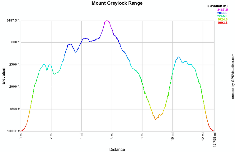 (The image at the left shows the profile of the hike. Remember that all vertical profiles are
relative!)
(The image at the left shows the profile of the hike. Remember that all vertical profiles are
relative!)
Mount Pisgah (PA)
| Quick Look | ||||
|---|---|---|---|---|
| Difficulty | Round trip | Total climb | Internet Maps | |
| 6.6 mi. | 1481 ft. | AllTrails | ||
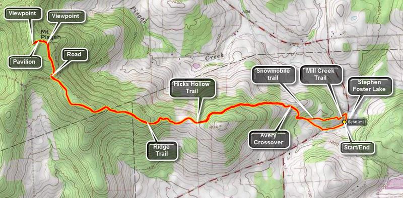
From Route 220 in Towanda turn west on Route 6. Drive 11 miles west to Route 3019 marked as Wallace or Bailey's Corners Road. Turn north and drive to the T in the road. Left will take you to the county park. Turn right to go to the state park. After a short distance, park in the lot next to Stephen Foster Lake. The lake is formed by a dam on Mill Creek. Start the hike by crossing the road and turning right toward the park. The Mill Creek Trail turns left off the road and starts up a hill for about .4 miles. Stay left on a snowmobile trail at a junction where the Mill Creek Trail turns right. You will soon arrive at the Ridge Trail where you should turn right. The trails are all marked with wooden signs and are well-maintained. After a short distance, the Ridge Trail begins to climb through a forest with one or two marked trails crossing the main trail. The trail continues through open places and then back into forest. It flattens in places and then climbs toward the summit. The trail finally dips a little and at 2.9 miles where it meets the road to the county park at the summit. There are several viewpoints on the way. As it flattens near the top there are some facilities and primitive campsites. Continue to the summit which has a pavilion and two communications towers. In the area facing west there is a nice viewpoint with some benches. A sign on the pavilion describes a lodge and observation tower that once stood on the summit. Retrace your route to the summit but stay on the Ridge Trail and walk out to the road. Cross to the other side and pick up the Oh! Susanna Trail that runs next to Stephen Foster Lake. Take this trail back to the parking area.
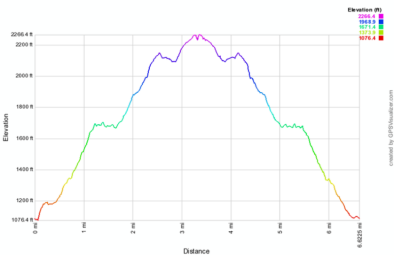 (The image at the left shows the profile of the hike. Remember that all vertical profiles are relative!)
Ricketts Glen
| Quick Look | ||||
|---|---|---|---|---|
| Difficulty | Round trip | Total climb | Internet Maps | |
| 7.3 mi. | 1560 ft. | AllTrails | ||
There are several different access points to this park depending on the activity you want. Even if you are hiking there are several different ways to approach the hike. One parking area is on Pennsylvania Route 118 west of Wilkes-Barre. The trail is on the north side of the road. Walk northeast on the trail and enjoy the wide, clear trail. Notice that there are many very large evergreen and hardwood trees still standing along the path. You will cross over the creek on small bridges until a larger bridge crossing at about .4 miles. At .85 miles the trail splits. The more difficult route goes down to follow the creek bed while the more moderate trail goes up and avoids the rough rocks. The trails meet at the first falls, Murray Reynolds at about 1.45 miles. There are three falls in quick succession before you arrive at Waters Meet at 1.7 miles. This is where the two glens, Ganoga Glen and Glen Leigh meet. You can go either way. Turn left and start up Ganoga Glen.
The trail starts to ascend now with many beautiful waterfalls occurring one after another. Each has its own character and is interesting in its own right. Take care as you walk on the trail. Springs in the hillsides make the trail muddy and slippery in many places. The trail passes close to the top of some of the falls and some of the drops are considerable. At 2.33 miles you will be at Ganoga Falls which is the highest in the park at just under 100 feet. After walking by these falls there will be several more before you reach the top of the glen. At 2.63 miles turn right onto the Highlands Trail to cut across to Glen Leigh. At 3.1 miles you will be at Midway Crevasse where the trail passes between several large outcroppings of sandstone. At 3.5 miles turn right to walk down the Glen Leigh Trail.
At 3.95 miles you will be at Huron falls which is the highest in Glen Leigh. This is followed by Ozone which is one of the nicest. Although the falls in Glen Leigh are not as high as the ones in Ganoga Glen, Glen Leigh gives you more of the feeling you are in a glen or gorge. The rock walls on either side seem to rise more sharply. At 4.35 miles you will be back at Waters Meet. From here you can retrace your steps until you are back at the road at 5.9 miles. Cross Route 118 and find a path to the right of the parking lot. Follow this path, the Evergreen Trail down to Adams Falls which has cut extensively through the bedrock. At this point you can return to your car to complete the 6.5 mile hike. You can also complete the Evergreen Trail which is only about a mile long. One this trail you will find some trees that were growing when Columbus discovered America.
 (The image at the left shows the profile of the hike. Remember that all vertical profiles are
relative!)
(The image at the left shows the profile of the hike. Remember that all vertical profiles are
relative!)
Riddell State Park: Blue Trail
| Quick Look | ||||
|---|---|---|---|---|
| Difficulty | Round trip | Total climb | Internet Maps | |
| 5.0 mi. | 858 ft. | AllTrails | ||
From Davenport Center on Route 23 follow Pine Lake Road north until it intersects Charlotte Creek Road. Turn left and drive .3 miles to Hartwick College's Pine Lake Center, on the left. You may also take exit 16 off I88 and follow Rt 47 until it become Rt 11. In West Davenport Rt 11 turns south. Continue on Charlotte Creek Road to the Pine Lake Center on the right. Ask at he office if it is OK to park in their lot. Cross the road and start up the hill following the trail that is marked Mud Lake. At the top of the hill turn left and continue to follow the Mud Lake signs. Almost immediately after turning left, turn right and follow the Tornado Trail. The trails are poorly marked and the blazes do not match the colors of the trails on the map! There has been little trail maintenance and this remains true on most of the trails. You will reach a T at .7 miles. Walk slightly to the right of the two signs carved onto dogs on the ground and look for some saplings which mark the start of the Blue Trail. The Blue Trail is marked in some places with white blazes and you may see some pink or orange flagging. This "trail" is not for beginners as it is little used and poorly marked! Walk down through the woods to pick up the white blazes on the Blue Trail. The blazes are far apart and some are missing. The site of an old steam mill is marked on the map but there seems to be nothing remaining. Just passed this area the trail starts to follow a woods road and it becomes more distinct with somewhat better blazing. This does not last! Eventually the blazes all but disappear. The trail generally heads north and uphill. At one point there is a rock shelf overhang. From that point on the trail is almost impossible to find. Finally at 2.45 miles the path swings more northeast. As you are walking and trying to spot blazes you may suddenly come to a wide trail which is the trail to Mud Lake. Turning left takes you around the north end of Mud Lake but this route is also NOT marked. Turn right and followed the Mud Lake Trail back to the junction with the Tornado Trail. From here walk straight out to the woods road and turn left and follow your previous route back to the car.
 (The image at the left shows the profile of the hike. Remember that all vertical profiles are
relative!)
(The image at the left shows the profile of the hike. Remember that all vertical profiles are
relative!)
Riddell State Park: Mud Lake
| Quick Look | ||||
|---|---|---|---|---|
| Difficulty | Round trip | Total climb | Internet Maps | |
| 6.1 mi. | 1040 ft. | AllTrails | ||
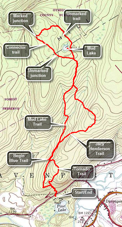
From Davenport Center on Route 23 follow Pine Lake Road north until it intersects Charlotte Creek Road. Turn left and drive .3 miles to Hartwick College's Pine Lake Center, on the left. You may also take exit 16 off I88 and follow Rt 47 until it become Rt 11. In West Davenport Rt 11 turns south. Continue on Charlotte Creek Road to the Pine Lake Center on the right. Ask at he office if it is OK to park in their lot. Crossed the road and start up the hill following the trail that is marked Mud Lake. At the top of the hill turn left and continued to follow the Mud Lake signs. Almost immediately after turning left, turn right and follow the Tornado Trail. The trails are poorly marked and the blazes do not match the colors of the trails on the map! There has been little trail maintenance and this remains true on most of the trails. You will reach a T at .7 miles. Turn right following the Mud Lake signed carved into a log on the ground! At .9 miles turn right off the main Mud Lake Trail to follow the Jacy Henderson Memorial Trail which was created in 2004. The "trail" consists of yellow paint splashed on trees and not much more! There are trees across much of the trail and the paint blazes are hard to see. The trail doesn't get much use so the trail bed is hard to follow. As the trail turns from northeast to northwest it runs through some briars and the blazes disappear. The blazes continue as you descend the hill heading north. You will have to follow them as the trail crosses a stream and marshy area. At 2.1 miles you will be back at the main trail. Turn right and follow some white paint blazes and random orange markers. At 2.4 miles, as you approach the pond, a sign post points to Mud lake one way and Route 58 in the opposite direction. Turn right and head to Mud Lake. When you get near the lake a few orange disks lead to a path toward the shore of the lake. The area is very marshy but some boards and sticks have been thrown down haphazardly. Be careful as you approach the shore of the lake as you are walking on a thick layer of sphagnum moss. After inspecting the lake, return to the point where you headed down to the lake. The park map shows a trail circling the north end of the lake but there are no blazes. There is a sort of a trail and some old pink and orange flagging. Follow this flagging and the path around to the north of the lake heading first northwest and then turning WSW. The flagging falters in several spots but continue to follow the path and begin looking for a connector trail on the left which will take you southeast and back toward the lake to complete the loop. If you do not find the connector trail, you may end up at I88! Fortunately, the trail improves some and at 3.4 miles there is a set of signs at a trail junction. Turn left on the connector trail back toward Mud Lake. At 4 miles you will be back at the junction with the Mud Lake Trail. Turn right follow the Mud Lake Trail back toward the car. At 4.3 miles you will pass the point where the Jacy Henderson Memorial Trail branches off. Stay on the Mud Lake Trail to cover some ground you did not covered on the way out. At 5.2 miles pass the memorial and the beginning of the trail. At 5.4 miles you will arrive at the Tornado Trail which will take you back to the parking area. Continue straight ahead on the Mud Lake Trail which eventually becomes a road. Continue down the road turning right and walking back down to the car where you ascended the hill at the beginning of the hike.
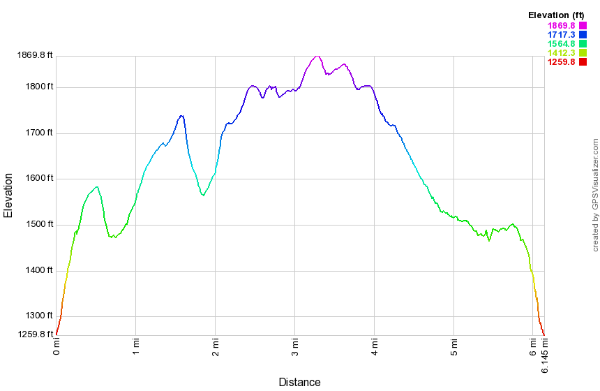 (The image at the left shows the profile of the hike. Remember that all vertical profiles are
relative!)
(The image at the left shows the profile of the hike. Remember that all vertical profiles are
relative!)
Salt Springs SP Falls
| Quick Look | ||||
|---|---|---|---|---|
| Difficulty | Round trip | Total climb | Internet Maps | |
| 1.7 mi. | 300 ft. | Alltrails | ||
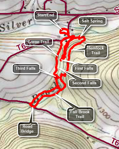
Get off I-81 for at exit 1. Turn right off the exit and after a short distance turn left on NY-7 South and then west for 3 miles. Turn right on PA-29 South and drive 6.4 miles to State Route 4008. Turn right and after a short distance left into the park. Park in the lot farthest away from Chadwick House. Walk out to the road you came in on. Turn right and walk upstream on the road bearing slightly to the right. The Gorge Trail starts as a very steep climb as evidenced by a rope on the side of the trail. This first climb is only .1 miles but it had a 20% grade. The trails here are poorly blazed and the signage is almost non-existent. There are three different falls near the beginning of the trail but it is hard to see the first two from the rim. You can hear the first falls but may find it hard to get a glimpse of it from the rim. Walk a little farther and the second falls appears through a break in the trees. At about half a mile the third falls which isn't quite as high as the first two appears. It has two drops and usually has a good volume. You can take pictures from the trail but the best shots are from in front of the lower drop. Be careful if you decide to work your way down to a rock shelf below the lower drop. Try to follow the blazes which head away from the stream and up the bank to a field. Walk along the edge of the field briefly and then head back down toward the stream. Within a short distance, you will see a road and ta bridge. Turn left on the road, walk across the bridge and turn left onto a path or trail. There may not be blazes here but after a walk through the weeds you should see a trail with red blazes. Follow this trail until it abruptly ends and then turn right up the hill on an informal path that leads up the steep bank. Walk the path which runs above the creek until you see a viewing platform. Climb the hill to get to the platform which has a sign that explains the gorge. The platform has no view. Walk on the boardwalk until you find a white blazed path which is part of the Hemlock Trail. There are some hemlocks in this forest that are estimated to be 500 years old. Like all hemlocks in the northeast they are threatened by the hemlock woolly adelgid. Continued on the trail as it descend to the stream again. Find an sign placed next to a "pool". This was one of the salt springs that gave the park its name. The sign explains that the spring has been frequented by native Americans and by white settlers. It was eventually turned into a commercial venture. Today the spring has seen better days but does have some water bubbling up from far below the ground. To walk to the first falls find a path along the eastern bank. The trip is not easy as the rocks are slippery and there is only a very informal path. Eventually you should make it to a point almost in front of the first falls. After taking pictures or just hanging out, walk back the way you came. As you come back to the picnic area, find the very large stepping stones with a rope to grip. Walk across the creek and back to your car.
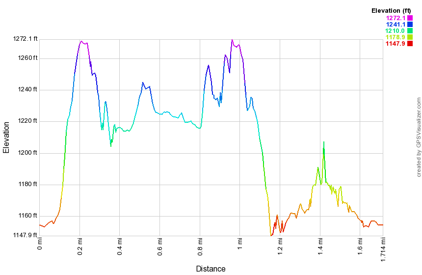 (The image at the left shows the profile of the hike. Remember that all vertical profiles are
relative!)
(The image at the left shows the profile of the hike. Remember that all vertical profiles are
relative!)
Shenandoah NP: Rocky Mount
| Quick Look | ||||
|---|---|---|---|---|
| Difficulty | Round trip | Total climb | Internet Maps | |
| 10.2 mi. | 3300 ft. | AllTrails | ||
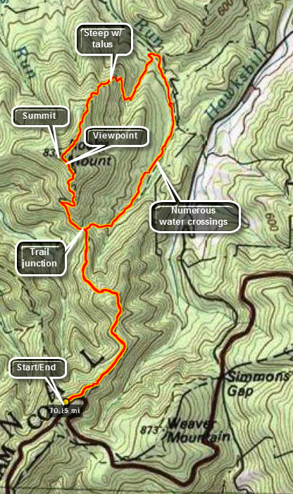 Shenandoah National Park is packed with hikes of all difficulties all of which have their own charm and interesting points. Many of these start on Skyline Drive and, therefore, the first and last parts of the hike are down and up respectively. Some water crossings can be challenging since they are meant for horses and have no bridges. The heat in the late spring, summer and early fall can be oppressive. Always be prepared.
The parking area for Rocky Mount is on the west side of Skyline Drive approximately 20 miles from the southern terminus. Headed north there is a ninety degree turn in the road just after this parking area. Park in the roadside pulloff and walk north until the trail signs appear on the left. The first 1.1 miles descend down from Skyline Drive and then there is a brief ascent of .3 miles to the top of a small hill. After this, the trail descends another .85 miles to the trail junction for the loop. Going left will take you up the front of the mountain first. Heading right takes you to the "back" of the mountain with several crossings of Gap Run. After turning right the trail crosses Gap Run at least five times without the benefit of any bridges. When the water is high it may be necessary to get wet, through some stone in the run or find a convenient downed tree across the water. From the junction the trail goes another 2.4 miles to the lowest point at the last crossing of Gap Run. From Skyline Drive the ascent has been 1535 feet! The ascent up to the summit of Rocky Mount now begins. It is steep in some places but there are switchbacks to help lessen the gradient. There may be some seasonal stream crossing but all are manageable. The hike up the back side of the mountain has several talus fields and offers some views of surrounding mountains. Savor these views as there are none from the summit. The ascent to the summit is 2 miles and almost 1500 feet. Over the top of the summit there are some limited views. The descent to the trail junction is about 1.25 miles but you are not done yet. There is still the 2.25 mile and 850 foot climb back to the car.
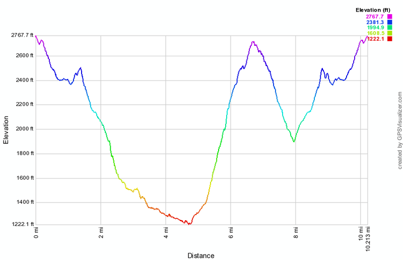 (The image below shows the profile of the "lollipop" hike. Remember that all vertical profiles are relative!)
Spruce Mountain Trail
| Quick Look | ||||
|---|---|---|---|---|
| Difficulty | Round trip | Total climb | Internet Maps | |
| 3.0 mi. | unknown | PDF map | ||
The Spruce Mountain Trail is on the grounds of the Spruce Lake Retreat Center on Route 447 near Canadensis, PA. The hiking trails are usually only available to guest ant the retreat center but arrangements may be made to hike the trails. Walk from the main lodge toward and in front of the program center. Turn left after the program center and before Carroll Cottage. Pick up the trail immediately. The initial part of the trail is gravel and well-maintained. Within a few hundred feet, the Lower Falls is on the left. There is an informal path to the base of the falls where you can get a better view. Continue on the main yellow-blazed trail to a road. Turn left an then immediately right onto the yellow-blazed Spruce Mountain Trail. The trail begins by following a stream but after a short distance the trail has been relocated away from the streambed due to flooding and erosion. Bushwhacking up the stream bed and following the faded yellow blazes allows you to see more small water falls before the Upper Falls but the relocated trail is definitely safer and avoids crossing the stream. Follow the trail as it ascends toward the Upper Falls. As you approach the Upper Falls, the trail can be very wet during most seasons and icy in the winter. It actually passes very close to the waterfalls. Just before the ascent another informal path on the right leads to a clearer view of the falls. At the top of the falls follow the trail as it runs left to ascend Spruce Mountain. The grade is moderate but by no means easy although there are several switchbacks. At the highest point on the trail you may be able to get some views depending on the season. Continue downhill a little farther where there is a rock ledge which gives and unobstructed view of the Spruce Lake Retreat Center in the valley. The view seems to go on forever with some mountains both near and far. The map from the center seems to indicate that the trail continues on from this point but the blazes fade and POSTED signs appear. Turn around a retrace your route back to the Upper and Lower Falls and the Retreat Center.
Sugar Hill Fire Tower
| Quick Look | ||||
|---|---|---|---|---|
| Difficulty | Round trip | Total climb | Internet Maps | |
| 0.7 mi. | 104ft. | AllTrails | ||
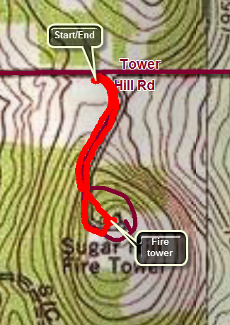 From Watkins Glen take Route 409 north and then turn right on CR-28. When CR-28 turns right After 1.2 miles to head north, turn left on the Mud Lake-Hammondsport Road. Drive 4.75 miles and turn left on CR-21. Drive 1 mile south to Tower Hill Road. Turn right and drive .6 miles to the parking area for Sugar Hill Fire Tower on the left. If the gates to the access road are open, you may drive directly to the parking area at the top. From the lower parking area walk over to the access road and turn left to head to the tower. There is a track in the grass beside the road and you may choose to walk most of the way along that track. As you approached the tower there is a loop around the top which is one way for cars. You may continue straight ahead and walk directly to the tower across the grass. At the top of the hill there is a nice recreation area and ample parking. Once at the top head over to the tower. This tower is a 67'6" International Derrick model 1937 tower and was erected in 1941 by CCC. It was staffed by volunteers until 1951, and then by the State until 1979. The cab is closed all year but the view from the top is still good. The view is even more beautiful in the fall when the leaves change color. The most notable feature is the blue water of Seneca Lake only 6 miles to the east. As you return to turnaround and prepare to leave you may find a USGS marker which indicates the elevation of the hill is officially 2096 feet. Retrace your steps to your car.
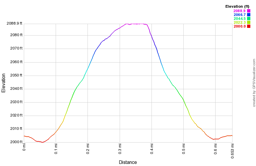 (The image below shows the profile of the "lollipop" hike. Remember that all vertical profiles are relative!)
Sullivan Branch: Waterfall Bushwhack
| Quick Look | ||||
|---|---|---|---|---|
| Difficulty | Round trip | Total climb | Internet Maps | |
| 1.6 mi. | 350 ft. | AllTrails | ||
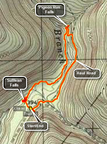
From Route 118 turn north onto Central Road. In Center take a right onto Jamison City Road. In Jamison City turn right onto Sullivan Falls Road to State Game Lands #13. Park in the parking area on the left side of the road about 2.5 miles up the road before a big right hand bend. This road starts as a reasonably paved back road and rapidly deteriorates to a one lane road with many eroded areas near the end.
From the parking area walk down to Sullivan Branch. The trail goes to the top of the falls where the stream has cut an impressive channel and flume through the bedrock. Looking down over the falls you can see the deep green of the plunge pool below. Walk back out the path but this time toward the base of the falls and the pool. The path is obvious but quite steep. Head back up the bank and walk the stream and the bank up to Pigeon Run where there is another falls. As with all of these bushwhacks, high water can make the falls much more enjoyable but the trip almost impossible. Low water conditions make the walking easier but the falls uninteresting. The Sullivan Branch can be clogged by blowdown for a good part of its length requiring you to move to the banks which may also be covered with downed trees and brush. Once you are passed Big Run the conditions should improve some and it is only .6 miles to Pigeon Run. The falls are actually on Pigeon Run in a narrow slot and so are different than most of the other falls on the main streams. Walk back downstream and up the steep left bank to an old haul road. The road is easy to follow and in pretty good shape. Follow it all the way back to the Sullivan Branch Road to within a few hundred feet of your car.
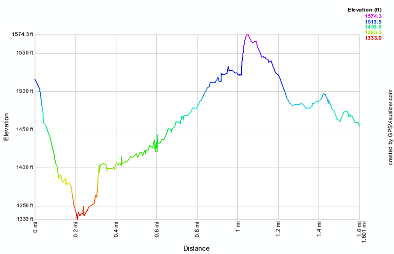 (The image at the left shows the profile of the hike. Remember that all vertical profiles are relative!)
Taconic: Bash Bish Mountain and Alander Mountain
| Quick Look | ||||
|---|---|---|---|---|
| Difficulty | Round trip | Total climb | Internet Maps | |
| 5.8 mi. | 2030 ft. | AllTrails | ||
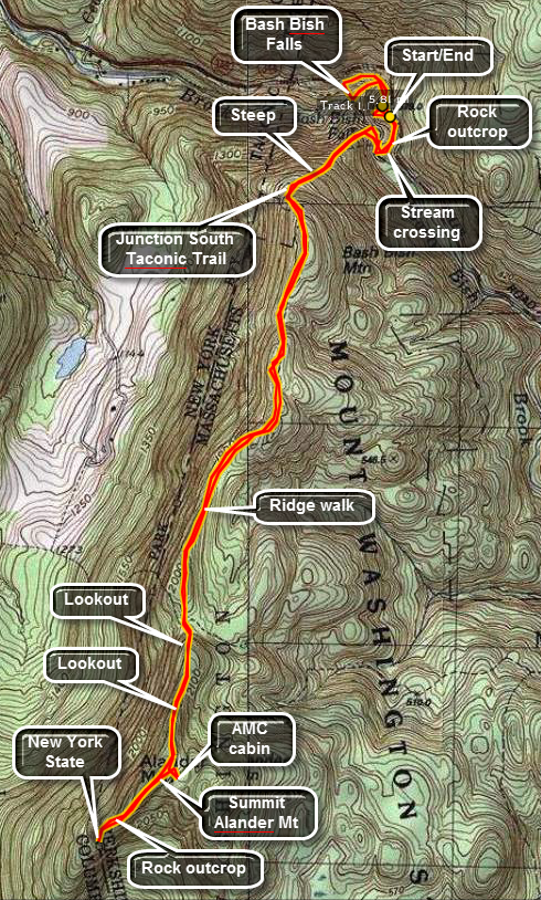 The parking area for this hike is on Falls Road (Route 344) which you can pick up in Copake Falls off Route 22 or by following the signs from Route 41 to Bash Bish Falls. Park in the lot. To get to the falls go to the trail to the right near the kiosk and descend to the fire road that leads to the observation point above the falls. Several different stream of water make up the falls depending on the volume of water. Continue down the steps to the base of the falls. The water falls into a pool at the base of the falls which then drains into the gorge formed by the creek over many years. The gorge is deep and well-cut attesting to the power of the stream when there is a large volume of water. Go back up the stairs and turn right to follow the blue marked trail on a loop back to the car.
Near the parking area is a LARGE outcropping of rock that overlooks the falls and the gorge. The climb up onto this outcropping can be interesting but is well worth the time and effort. The views down the gorge and out to the surrounding area are beautiful. You can follow the guide rails and cables around to look down into the gorge to the stream below. Some foolish people have obviously gone beyond the fencing but you will stay where it is safe. After taking in the views, return to the parking area to begin the hike to Slander Mountain.
From the parking area take the fire road that is at the opposite end of the lot from the Falls Trail. This is the Bash Bish Gorge Trail and is marked with blue paint. You will have to bear right at the end of the road and then find a way to cross over the stream. Depending on the water level, this may be easy or dangerous. The trail markings on both sides are not very clear. Once on the other side ascend the STEEP trail out of the gorge. You may need to use the available tree roots and branches combined with the guide rails and cables. Stop at several points to take in the view including the one down the gorge and the one directly down into the gorge. Continue on the trail but pay attention to where you are going. There are MANY blowdowns along the way which obscure the trail and hikers have taken several different routes around them. Very shortly signs will indicate that you may turn left or right onto the South Taconic Trail. Make sure you turn left and ascend! The trail makes a steep but short ascent to the Alander Mountain Ridge. From here the trail undulates some but most of the climbing is done.
Once you are on the ridge the summit of Alander is about two miles away. The trail passes through hardwood forest. At some spots there is a canopy of mountain laurel and in others you are surrounded by dwarf pines. As you walk it is obvious that the trail drops off on either side. At points the parallel ridges on either side are visible. In the fall, when the leaves are off the trees, views down into the valleys and across the hills are available. Take a quick peek but don't waste too much time since the best views are yet to come. As you approach Alander the trail starts a very moderate climb and begins to open up to low bushes. Views from here are available In all directions except to the south since this direction is still blocked by the mountain. As you ascend the views just keep getting better. Near the top a rock cairn and signs show the various trail options including the Alander Mountain Trail to the Mount Washington State Forest Headquarters. This trail is the shorter, easier way to get to the top! At the summit are the cement pilings that once anchored a long gone tower.
Continue on the trail and look south to see wonderful views of Mount Ashley, Brace Mountain and Mount Frissell. There are also views to both the east and west. Just down the trail you will see another rocky outcropping. Head down the trail making this outcropping your goal. There is slight descent and then ascent to this area. Along the way you can walk back and forth on the mountain to make sure you get every view possible. From the outcropping the mountain drops away making the views even better. Just below this area there is a small granite marker on the trail. This marks the New York-Massachusetts boundary. When you are on the other side of the marker, you are at the highest point in Columbia County, New York. Head back to the summit. You can now simply return to the car or take a side trip.
Turn right onto the Alander Mountain Trail. Within several hundred feet you will see a small cabin. This is an Appalachian Mountain Club cabin which can be used on a first come first served basis. It has a wood stove and several bunk beds. Once you have seen the cabin follow the trail back up to the South Taconic Trail. Follow the South Taconic Trail back to the Bash Bish Gorge Trail across the stream and back to the parking area.
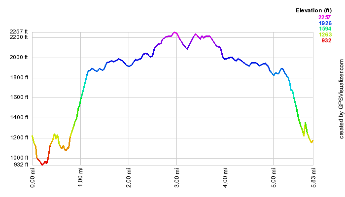 (The image at the left shows the profile of the hike. Remember that all vertical profiles are
relative!)
(The image at the left shows the profile of the hike. Remember that all vertical profiles are
relative!)
Taconic: Berlin Mountain and the Snow Hole
| Quick Look | ||||
|---|---|---|---|---|
| Difficulty | Round trip | Total climb | Internet Maps | |
| 11.4 mi. | 2466 ft. | AllTrails | ||
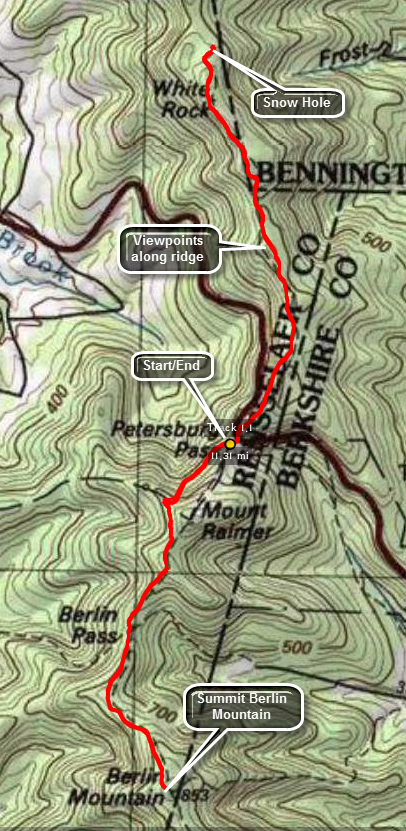 The parking area for this hike is on Route 2 at the Petersburg Pass just outside Petersburg, NY and on very near the Massachusetts and Vermont borders.
The parking area is very large and on the right side of the road as you head toward Massachusetts. Sign in at the trail register at the back right of the parking area and head out on the Taconic Crest Trail. The first part of the trail is overgrown with weeds but it soon gives way to a wider trail and woods road. Start a short but steep ascent part way up Raimer Mountain. Once on the crest of the ridge the trail flattens a little before rising to around 2450 feet. The trail then descends toward Berlin Pass. Just before the descent, views of Berlin Mountain can be seen through the trees. The trail drops more than 200 feet to 2230 feet at Berlin Pass before starting up Berlin Mountain. The 1.2 mile climb gains almost 600 feet. When you arrive at the flat, open top of Berlin Mountain, you will be about 2.75 miles into the hike. There will be some good views but how good they are depends on the amount of haze. To the west it is easy to spot Mount Greylock with its two towers. There are profile views of Mount Williams and Mount Fitch to the north of Greylock. Views in the other directions are at least partly blocked by the trees. Return the way you came to the parking area which is about 5.5 miles of hiking.
Cross the road to find the trail on the other side. The first few hundred feet of the hike north are very steep with some steps to make the climb easier. Near the top of the climb there is a trail register and a sign explaining that the area is part of the 2500 acre Hopkins Forest which is owned and maintained by Williams College. There are usually extra trail maps in the bin by the sign! As you start up the trail, another spur trail leads off to the left. Take this trail to get some more views down an old ski slope. There are great views back to Raimer Mountain and to the east and south. Return to the Taconic Crest Trail which is very well maintained in this area. At about .6 miles from the Pass or 6.3 miles into the hike, the Shepard's Well Trail comes in from the right. The main trail continues to rise although gently in most cases. In another .6 miles the Birch Brook Trail joins from the right. After this the trail ascends and there are some excellent views to the west. In another .5 miles the trail briefly crosses into Vermont and then heads back into New York. At 2.5 miles from the Pass or 8 miles into the hike the trail starts to descend. In another .25 miles a red spur trail turns off to the right. This trail leads to the Snow Hole after a short descent. The Snow Hole is a deep cleft in the rock which is supposed to have snow and ice in it until mid-July. Even when there is no snow, the Hole is cool and damp and dark. Retrace your path back to the Taconic Crest Trail and turn left to get back to the car,
(The image at the left shows the profile of the hike. Remember that all vertical profiles are relative!)
Taconic: Mount Everett and Mount Race
| Quick Look | ||||
|---|---|---|---|---|
| Difficulty | Round trip | Total climb | Internet Maps | |
| 8.7 mi. | 3156 ft. | AllTrails | ||
 As with most hikes there are several approaches to these mountains. It is even possible to drive with about a mile of the summit of Everett and then hike about 700 feet in elevation to the top. This is the northern approach and misses the beautiful Race Brook Falls! The route from the south through Sage's Ravine is much longer. The approach from the east between the two mountains takes in the falls and both mountains. It is challenging but not too difficult.
The trailhead for this hike is on Massachusetts State Route 41 about 1.5 miles south of the Berkshire School. Park at the trailhead and go into the woods passed the kiosk and onto the blue marked Race Brook Falls Trail. The trail starts out moderately through some hardwood forests which alternate with evergreens along the way. The first brook crossing might be tricky in high water but otherwise is no problem. After only half a mile of moderate incline a side trail leads off to the left. This trail leads to the lower tier of Race Brook Falls. It is well worth the detour and places you at the foot of a 90 foot cataract. The trail is steep in places and blocked by some blowdown which has been there for a while. You can stand at the bottom of the falls and admire both the power and the beauty of the falling water. When you are done, retrace your steps back to the main trail and continue on.
The trail begins to ascend more steeply now through evergreen forest and leads to the upper tier of Race Brook Falls. After only about a quarter mile you are there. This tier is similar to the lower one. It is not quite as high but perhaps more delicate. The trail crosses at the base of the falls. This is no problem in times of low water but can be dangerous or impossible when the water is high. The trail now ascends more sharply up to a more level area. Glimpses of the surrounding hills suggest the views that will be much clearer from the summits! In less than a mile, the platforms of race Brook Primitive Campsite appear. There is one stream crossing that is no problem but does have a two-log bridge! Walk through the campsite and up a set of stone steps. You will soon be at the junction with the white marked South Taconic Trail which is also part of the Appalachian Trail. Turning left leads to Mount Race and right to Mount Everett. The trail is POORLY MARKED in places so be careful to watch where you are going.
Turn right toward Mount Everett. As you walk along the relatively flat trail the first views of Mount Everett appear and although the mountain is not very high it does seem imposing. After only a quarter mile the climb up Everett begins. This is a no-nonsense approach that heads straight up the mountain with few switchbacks to moderate the climb. The trail passes over some open rock outcroppings which can be slippery although it is possible in some cases to pass to one side or the other. None of these areas could be classified as difficult or approaching a rock scramble but they are not easy either. Near the top the trail begins to level out and pass through some interesting ecosystems. Dwarf pines alternate with scrub oak and warm climate species like sassafras can be seen. You will suddenly realize that you are out of the forest and the open views of the surrounding mountains and valley will take your breath away. Immediately behind you on the climb is Mount Race as well as several other mountains and hills.
Near the summit of Everett are the remains of the Mount Washington Observation Tower. All that is left are the cement pylons that anchored the base. You can turn around at this point and retrace your path but walking to the other side if the summit is well worth it. As you walk down the trail a large rock outcropping on the left affords another set of breathtaking views. The trail continues down the north side of the mountain and intersects a fire road. Both the fire road and the trail descend to Guilder Pond. The descent is about 600 feet but only about three quarters of a mile. The pond is very pretty with a loop trail. After a visit to the pond use the trail or the road to climb back to the summit. Follow the trail back down the other side to the junction with the blue trail. Continue straight ahead on the South Taconic Trail that leads to the summit of Mount Race. The initial part of this trail has several steep but short spots. It then ascends continuously to the ridge line that leads to the summit of the mountain. From the trail junction to the summit is a little less than a mile.
As you near the summit the trail opens up and the first thing you notice is Mount Everett directly behind you! Other hills and valleys are also laid out below. After the summit continue southward on the trail. There is a slight descent and a large rock cairn will come into view. At the same time you see the cairn you will notice that there are open views to the south. Walk around this area before returning to the summit. Follow the trail back to the Race Brook Trail where you will make a right and walk back to your car.
 (The image at the left shows the profile of the hike. Remember that all vertical profiles are
relative!)
(The image at the left shows the profile of the hike. Remember that all vertical profiles are
relative!)
Taconic: South Brace Mountain and Brace Mountain
| Quick Look | ||||
|---|---|---|---|---|
| Difficulty | Round trip | Total climb | Internet Maps | |
| 3.3 mi. | 1500 ft. | AllTrails | ||
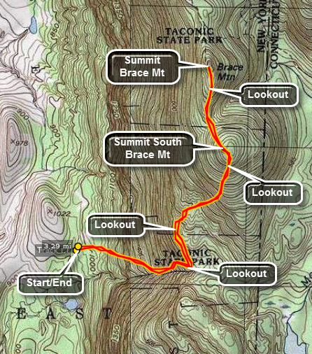 These two mountains are actually in New York state and are part of the Taconic State Park. The best way to access the parking area is to go south from Copake Falls or north from Millerton on Route 22. Look for Whitehouse Rd. on the east side of Route 22. Turn onto White house Road and follow it a short distance to where it ends on Route 63 also called Undermountain Road. Take the next right onto Deer Run Road. After a very short drive up a hill, Deer Run goes straight ahead and comes to a dead end. Take the left onto Quarry Hill Road and watch for the small parking area on the left with a sign that says Taconic State Park. Park here to get on the trail. DO NOT walk up the wide woods road next to the parking area. It is private property and does not lead to the trail.
The white marked South Taconic Trail starts out through a field and then enters a hardwood forest. The initial, gentle hiking belies what is to come! Within a quarter mile the trail begins to parallel a stream. The sights and sounds of the stream are relaxing but the trail begins to climb steeply along the banks of the gully cut by the stream. The trail is poorly marked and you should pay careful attention to where you are going. Other hikers have taken various routes so the actual path of the trail can be obscured. Some of these detours do make the climb easier but some do not. As you near the half mile point the trail gets even more serious with a climb up over sheer rock faces with some tough "ups" particularly for those who are "vertically challenged"! Fortunately, this does not last for long and you are on a much flatter area of the trail. On the way up be sure to carefully look over your shoulder. The views that are revealed of the valley below hint at what can be seen from the top of the mountains.
As the trail levels off there are several areas where you can safely enjoy the views before moving on. The trail from this point on is much flatter with a slight incline as you climb toward South Brace Mountain. Watch the trail markings since it is easy to head the wrong way. The trail does pass over some rocky spines and outcroppings but the incline is not steep enough to be much of a problem. As you ascend South Brace the views become even more magnificent. As you turn around Riga Lake and South Pond will be in front of you on the right. They form an interesting break in the hill and valley terrain that is so common. The summit of South Brace is just ahead at about 1.2 miles.
Continue on the trail for less than half a mile to the summit of Brace. There is a short descent into a col between the two mountains but you will hardly notice it. As you climb up to the top of Brace the most prominent feature on the mountain is a LARGE pile of stones with a permanent windsock attached. Brace Mountain is one of the primary launch points for the Connecticut Hang Gliding Association and other enthusiasts. You may expect to see launches any time you are on the summit. The view to the east, west and north are wonderful so take them in before you start back to the car.
Simply turn around and follow the trail back the way you came up the mountain. Be careful since the descent can be dangerous especially when there are leaves, water, ice or snow on the trail.
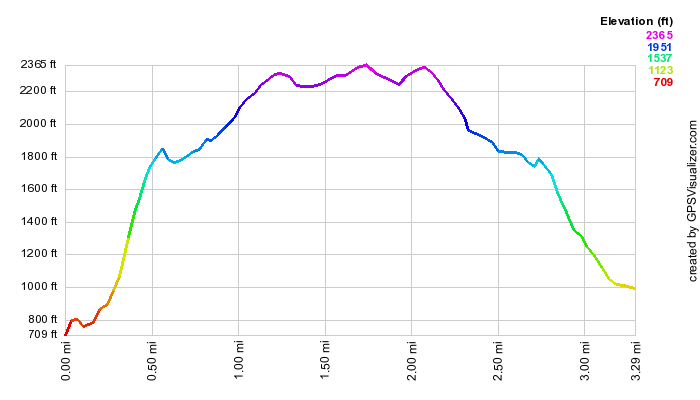 (The image at the left shows the profile of the hike. Remember that all vertical profiles are
relative!)
(The image at the left shows the profile of the hike. Remember that all vertical profiles are
relative!)
Taughannock Falls State Park (NY)
| Quick Look | ||||
|---|---|---|---|---|
| Difficulty | Round trip | Total climb | Internet Maps | |
| 5.0 mi. | 1060 ft. | AllTrails | ||
From the junction of Routes 96 and 89 in Ithaca, NY, head north on Route 89. Drive for about 9 miles and watch for signs for Taughannock Falls State Park. Park in the parking area on the west side of the Taughannock Falls State Park.
Walk into the gorge on the Gorge Trail and watch for several small falls along the way. The canyon that has been cut over the years is impressive. A layer of rock acts as the stream bed in many places and shows "waves". In many areas the different hardness of the rock layers is evident in the erosional patterns. You will arrive at the bridge over the stream at the base of the falls. The main falls are certainly high and are listed at 215 feet in mist books. Walk back to the beginning of the Gorge Trail, and start UP to the South Rim Trail. Getting up to the rim requires quite a climb but there were MANY stone steps along the way. Once you are up on the rim, the trail levels out and passes through shaded groves of the hardwood and some evergreen trees. Along the way a few lookouts give interesting views of the canyon below and, eventually, of the falls itself. Soon you will be near the upper reaches of the gorge and a new falls comes into view. Here the gorge widens considerably and the different layers of rock are even more obvious. Soon a bridge comes into view to cross over the stream. The bridge is a little old and has seen better days. From the bridge another falls, as impressive as the main falls in many ways, appears on the left to the southwest of the bridge. The water here also falls a long distance and the volume appears to be as great as the main falls. A little further upstream is another bridge that routes traffic over the stream. Continue on the trail but take the short side trip to the road bridge and back before continuing on the main trail. As you walk along the main trail an occasional view of the gorge will appear. The trail winds along the gorge and even joins the road for a brief time. At the upper access to the park and the gorge is a flight of stone steps to a view of the falls from some stone "benches". Start back down the North Rim Trail to the car. Try to find a view down the gorge and out to Cayuga Lake. Many of the viewpoints are overgrown and the views are obscured by trees and bushes. Continue down the trail looking for viewpoints before descending the steps to the road a little north of the parking area. Walked the road back to the car.
 (The image at the left shows the profile of the loop hiking route. Remember that all vertical profiles are relative!)
Vroman's Nose
| Quick Look | ||||
|---|---|---|---|---|
| Difficulty | Round trip | Total climb | Internet Maps | |
| 1.5 mi. | 585 ft. | AllTrails | ||
The area around Middleburgh is best known for this hike up Vroman's Nose. This high, rocky prominence stands some 600 ft. above the flat Schoharie plain. The creek shows meanders below. Also in the area are Thacher Park and the Middleburgh Cliffs which also offer a nice view of the Schoharie Plain and Vroman's Nose itself.
From Route 30 through Middleburgh, turn west on West Middleburgh Road. Drive for about .6 miles and park in the lot on the left. Walk up through the field and at the base of the "Nose" make your choice of left or right. The trail makes a large circle over the "Nose" and neither direction is more difficult or easier. You will climb to the top of the rock outcrop with no views other than the trees. Once on the top the views appear one after the other and they are spectacular. When you have taken in all that you can, continue your loop back to the parking area.
 (The image below shows the profile of the loop hiking route. Remember that all vertical profiles are
relative!)
(The image below shows the profile of the loop hiking route. Remember that all vertical profiles are
relative!)
Watkins Glen State Park (NY)
| Quick Look | ||||
|---|---|---|---|---|
| Difficulty | Round trip | Total climb | Internet Maps | |
| 2.5 mi. | 745 ft. | AllTrails | ||
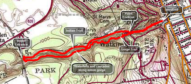
The lower entrance to the park is right on Route 14 or Franklin Street on the west side of Watkins Glen. There is a parking fee if you use their lot. The lot fills quickly especially on weekends. Public parking is available elsewhere in the village.
Walk into the gorge on the Gorge Trail and be prepared to be amazed at the deep chasms, numerous cascades and waterfalls and the other interesting features of the glen. It really is spectacular to see the depth the stream has cut over the years and the formations that have resulted. Bring a camera but don't expect to really capture all the beauty you see around you. Take in all the deep chasms, narrow channels and circular pools cut by the stream. In several places the trail takes you underneath waterfalls and across the stream. The trail is wet in spots and can be slippery. Be prepared for a crowd of people especially on the weekends. Aim to hike midweek and when school is in session if you can. Farther up the glen the stream widens and the flow slows. Almost as impressive as the forces of nature that formed the glen are the manmade structures that allow access. There are walkways cut into the glen and many are paved with some to make them smoother. There are over 800 stone steps from one end to the other which are challenging but easier than climbing without them. There are several bridges that pass across the stream and some are high in the air connecting the north and south rim. When you pass Mile Point Bridge you know you are almost at the upper end of the glen. When you climb the last stone staircase you will have hiked 1.25 mile. You may return the same way you came or turn right at the top of the steps onto the Indian Trail. This trail is not as scenic as the Gorge Trail but is easier to negotiate. Walk downhill back to Point Lookout at 2.2 miles. The Indian Trail ends here as it unsafe past this spot. Descend the steps to the Gorge Trail and return that way to the parking area.
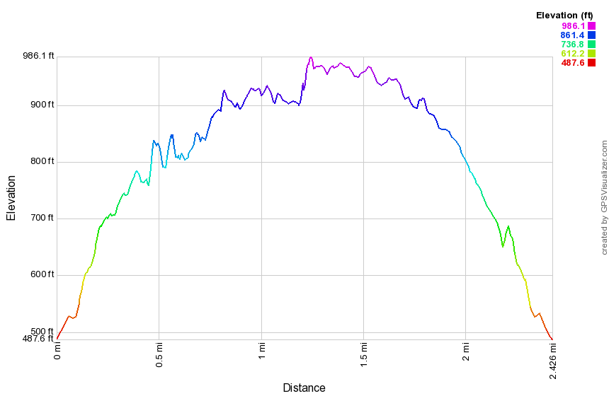 (The image at the left shows the profile of the loop hiking route. Remember that all vertical profiles are relative!)
West Rim Trail: Grand Canyon of PA
| Quick Look | ||||
|---|---|---|---|---|
| Difficulty | Round trip | Total climb | Internet Maps | |
| 7.3 mi. | 1360 ft. | AllTrails | ||
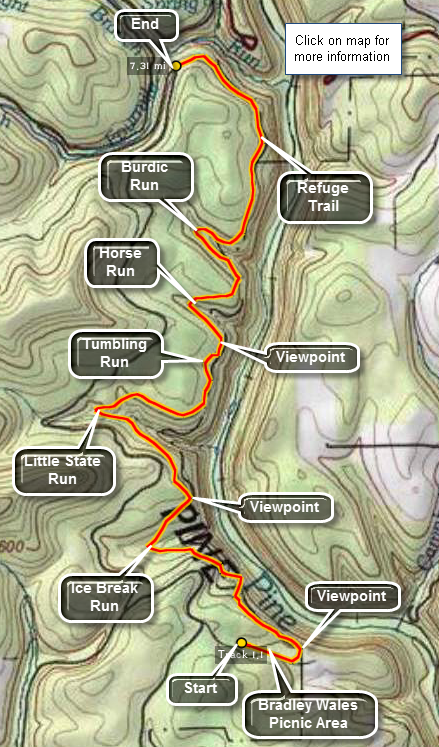 Pine Creek Gorge is sometimes known as the Grand Canyon of Pennsylvania. The gorge was cut at the end of the last ice age when the receding glacier blocked drainage to the north. The glacial met waters drained southward cutting a deep gorge as several side canyons. Pine Creek is now considerably smaller but the gorge remains. It stretches almost 40 miles from Ansonia in the north to Blackwell in the south. Hikers often hike the West Rim Trail in whole or in part. The trail can be accessed from the northern or southern trailheads or from points along Colton, Painter-Leetonia, and West Rim Roads. Car shuttles are popular as they allow hikers to cover more of the trail. The main trail parallels the gorge and has many viewpoints that allow hikers to look down into the gorge, across to the opposite rim and up and down the gorge. The trail moves away from the rim where tributaries have cut deep side canyons. There are few steep ascents and descent. A rail trail is now in place on the floor of the gorge where the Penn Central tracks used to be. This trail is covered with fine crushed rock and is appropriate for hiking, mountain biking, snowshoeing or cross country skiing. Colton Point State Park occupies the northwest rim and is relatively "wild". Leonard Harrison State Park is found across the gorge on the northeast rim.
This hike covers about 7.5 miles of the West Rim Trail from Bradley Wales Picnic Area in the south to a hairpin turn on Painter-Leetonia Road in the north. Find Ansonia, Pennsylvania on Route 6 and turn south on Colton/Forest Road. As you drive on the road watch for a parking area on the right side of the road and a lookout on the left. This allows you a first look into the gorge. Continue south for 6.5 miles and turn left on Painter-Leetonia Road. At 8.3 miles make another left on Painter-Leetonia Road. Park your car at the hairpin turn at 9.1 miles on Painter-Leetonia Road at the trailhead for the Refuge Trail. Continue south for another 5 miles and watch for a slight turn to the left on Bradley Wales Road. At the end of the road park your car in the parking area.
The West Rim Trail is marked by bright orange paint blazes and starts to the right of the parking area. Walk up the road and watch for a SHARP left turn into the woods. There is a viewpoint almost immediately. Continue to walk on the trail which turns briefly away from the rim to cross an unnamed tributary. Further along at 1.4 miles is a large detour around Ice Break Run. A "blue" trail meets the main trail at the head of the run. These trails lead directly to the park roads and allow quick access to these areas. Just after Ice Break there is another nice lookout. The trail then travels the rim briefly before turning up Little Slate Run at 2.0 miles. This is by far the longest detour as the canyon is the steepest and deepest. Walk to the head of the run, cross the run and hike back down the other side to the gorge rim. Another lookout greets you at this point.
After Little Slate are Tumbling Run, Horse Run and Burdic Run and various viewpoints along the way. After Burdic Run there is a rather long section of trail without any lookouts. The trail travels through some nice pine groves and is mostly flat. Watch for the orange blazes to turn abruptly left and go up and over a hill. DO NOT take this trail. Continue straight ahead on the blue blazed Refuge Trail which is less than .5 miles from the trail junction.
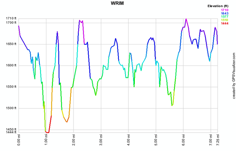 (The image at the left shows the profile of the hike. Remember that all vertical profiles are
relative!)
(The image at the left shows the profile of the hike. Remember that all vertical profiles are
relative!)
York River State Park Virginia: Pumunkey Tower
| Quick Look | ||||
|---|---|---|---|---|
| Difficulty | Round trip | Total climb | Internet Maps | |
| 5.4 mi | 330 ft | AllTrails | ||
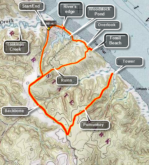 York River State Park in Virginia is on the York River which is a tidal estuary at that point. It is 11 miles west of Williamsburg, Virginia. There are many small creeks and salt marshes in the park. All of these offer habitats for varying kinds of wildlife including eagles and ospreys. The park also has historical significance as it was part of the Taskinas Plantation going as far back as the 13 colonies. It was a place where growers would gather their products, especially tobacco, for shipment back to England. The park is quite flat with only a few hills. It has an extensive trail network for hiking, mountain biking and horseback riding. Some trails are designated for more than one use while some are reserved for only one. The entire park covers 2550 acres and has over 25 miles of trails, a visitor's center and picnic shelters.
To get to the park take I-64 and get off at exit 231B for Croaker. Go north on Route 607 (Croaker Rd.) for one mile, then right on Route 606 (Riverview Rd.) about one and a half miles to the park entrance. Take a left turn into the park. DO make the turn onto Riverview Road. Going straight ahead will take you to the boat launching area. DO NOT give up when it seems like Riverview is the wrong way. You will get to the park entrance. The day that I was at the park was technically late winter but looked more like early spring. The skies were overcast and threatening rain with temperatures in the high 40's to mid 50's. Stop at the entrance to pay the use fee to the attendant or place it in an envelope and deposit in the "off" season. The maps available are barely adequate if you have not been here before but make more sense after you walk around for a while.
Park the car near the visor's center and walk to the right of the building toward the kiosk. Start out on the Woodstock Pond Trail. After a few hundred feet, turn left and walk down the stairs to the shore of the river. The beach here is sandy and there are nice views up and down the shire and across the river. Walk back up to the main trail, turn left and walk past Woodstock Pond on the right. Stop at the pond for a moment if you want and then take your next left on The Mattaponi Trail that leads down to a bridge across a salt marsh. The trail leads to a wooden lookout deck which gives nice views of the river but better views are available from just off the deck. Take the side trail marked Fossil Beach which leads down to the river edge. This is definitely worth the short side trip. Walking on the beach you may find a fossil but you will surely enjoy the views of the high, sandy bluffs and the river. Go back up the side trail and out to the Mattaponi Trail and turn left to walk out to the Woodstock Pond Trail. At the trail junction walk over to the old brick foundation of the summer home of a prominent Williamsburg doctor. Walk out to the Backbone Trail and turn left.
Walk generally south following the Backbone Trail for about .85 miles ignoring all the crossing trails until you get to the Pumunkey Trail on the left. This trail is about .85 miles long and will take you down to an observation 'tower' at the edge of the river. The 'tower' is an elevated platform perhaps 10 feet high so don't get too exited. When you have finished "observing", walk back out the Pumunkey Trail to the Backbone Trail and turn right. Follow the Backbone Trail for 1.4 miles back to the car. There are many other options that would include more trails and point of interest along the way. Consult the map from the park entrance booth and read the description of the hike below.
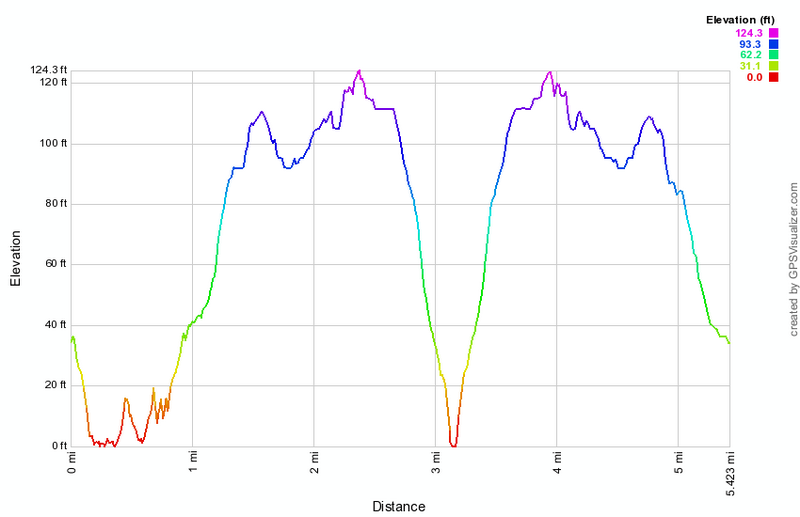 (The image at the left shows the profile of the looping hike. Remember that all vertical profiles are relative!)
York River State Park Virginia: Taskinas Loop
| Quick Look | ||||
|---|---|---|---|---|
| Difficulty | Round trip | Total climb | Internet Maps | |
| 10.7 mi | 704 ft | AllTrails | ||
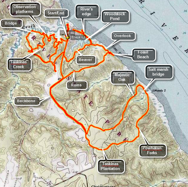 York River State Park in Virginia is on the York River which is a tidal estuary at that point. It is 11 miles west of Williamsburg, Virginia. There are many small creeks and salt marshes in the park. All of these offer habitats for varying kinds of wildlife including eagles and ospreys. The park also has historical significance as it was part of the Taskinas Plantation going as far back as the 13 colonies. It was a place where growers would gather their products, especially tobacco, for shipment back to England. The park is quite flat with only a few hills. It has an extensive trail network for hiking, mountain biking and horseback riding. Some trails are designated for more than one use while some are reserved for only one. The entire park covers 2550 acres and has over 25 miles of trails, a visitor's center and picnic shelters.
To get to the park take I-64 and get off at exit 231B for Croaker. Go north on Route 607 (Croaker Rd.) for one mile, then right on Route 606 (Riverview Rd.) about one and a half miles to the park entrance. Take a left turn into the park. DO make the turn onto Riverview Road. Going straight ahead will take you to the boat launching area. DO NOT give up when it seems like Riverview is the wrong way. You will get to the park entrance. The day that I was at the park was technically late winter but looked more like early spring. The skies were overcast and threatening rain with temperatures in the high 40's to mid 50's. Stop at the entrance to pay the use fee to the attendant or place it in an envelope and deposit in the "off" season. The maps available are barely adequate if you have not been here before but make more sense after you walk around for a while.
The Taskinas Creek Trail was marked 'Closed due to storm damage.' but is fairly easy to hike although missing some bridges. The trail parallels the creek for a distance and has wooden platforms with benches to observe the wildlife. About a mile into the hike a bridge crosses the creek and is twisted but sound. From this point on the trail heads through the forest and over some hills to an area about 1.74 miles from the beginning where you can go straight ahead head back to the parking area to find another trail. You may also choose to turn right and walk the ?new" trails that cover some of the same ground you already walk through. Be prepared to bushwhack at some point until the trails are completed. Once back at the trail junction go straight ahead out to the road and walk back toward the parking area. Just short of the parking area make a right onto the Backbone Trail, a multi-use trail that runs the length of the park. In a few hundred feet make and immediate left onto the Beaver Trail and at the end another left onto the Woodstock Pond Trail. Walk passed Woodstock Pond and take a right down some steps to the shore of the river. Spend some time on the sandy beach before heading back the way you came passing Woodstock Pond. Take the next left onto the Mattaponi Trail that leads down to a bridge across a salt marsh. The trail leads to a wooden lookout deck which gives nice views of the river but better views are available from just off the deck. Take the side trail marked Fossil Beach which leads down to the river edge. This is definitely worth the short side trip. Walking on the beach you may find a fossil but you will surely enjoy the views of the high, sandy bluffs and the river. Go back up the side trail and out to the Mattaponi Trail and turn left to walk out to the Woodstock Pond Trail. At the trail junction walk over to the old brick foundation of the summer home of a prominent Williamsburg doctor. Walk out to the Backbone Trail. You will have walked 6 miles and turning right will bring you back to the parking area. Turn left on the Backbone Trail.
Walk generally south following the Backbone Trail for about .85 miles ignoring all the crossing trails until you get to the Pumunkey Trail on the left. Turn left here walk .1 miles and turn right on the Spurr Trail. Walk .15 miles and turn left on the Majestic Oak Trail. About .6 miles down this trail, as you head for the river, will be a large oak tree with a plaque explaining its significance. Continue on the trail and walk over a wooden causeway across another salt marsh. The trail continues to loop around and heads away from the river. DO NOT turn left unless you want to lengthen the 10 mile hike! Take the first right which will be the Powhatan Forks Trail. At the next right will be a gate and the foundations of the Taskinas Plantation. All that remains are shallow impressions and some bricks. DO NOT turn here but continue straight ahead to the Backbone Trail. Turn right and stay on this trail all the way back to the park road and your car about 1.5 miles away.
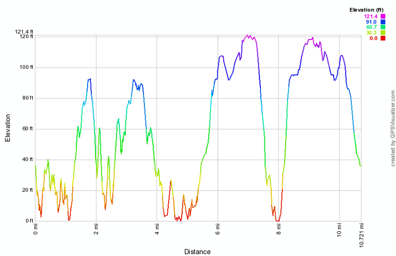 (The image at the left shows the profile of the looping hike. Remember that all vertical profiles are relative!)