
New Jersey Trails
Besides the thirty-five 3500 foot peaks in the Catskills, there are many other smaller mountains to climb. In addition, there are hundreds of miles of trails to hike. There are also MANY other places to hike also. I have divided the Trails section into list of All Trail, the Catskills, the Shawangunks, Bear Mt/Harriman, East Hudson, West Hudson, New Jersey and Other Trails. The All Trails list includes over 400 different trails and may load slowly on your computer. The "divided" list should load more quickly.
You can view all the New Jersey Trails here.
Clicking on ![]() will bring up an index of trails. Clicking on
will bring up an index of trails. Clicking on ![]() will return you to the top of the page.
will return you to the top of the page.
Bearfort Ridge: Surprise Lake and West Pond
| Quick Look | ||||
|---|---|---|---|---|
| Difficulty | Round trip | Total climb | Internet Maps | |
| 3.94 mi | 1140 ft | AllTrails | ||
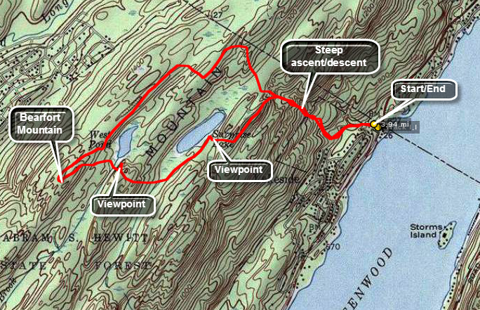
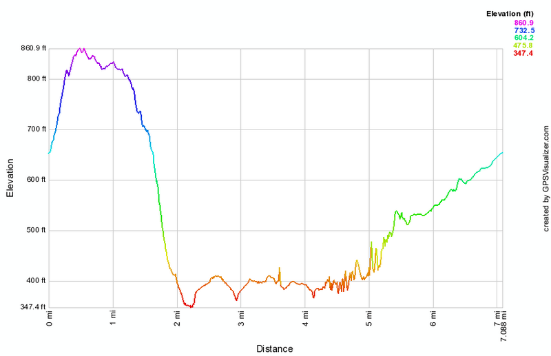
Park in the parking area on Route 210 just south of the New York border. Route 210 runs parallel to the western shore of Greenwood Lake and there are many marinas and boat ramps in the area. This parking area is hard to find as it looks like you are turning into the parking lot for one of the marinas on the side of the road away from the lake. From the parking area get on the blue State Line Trail and follow it up to the ridge. This area is popular and there may be no definite path defined. Keep watching for the trail markers as the trail ascends about 650 feet in the first .6 miles. This is almost a 20% grade and is a little steep. Near the top of the climb leave the State Line Trail and turn left on the yellow Ernest Walter Trail that travels along the ridge and to the shore of Surprise Lake where there is a nice viewpoint over the lake. Stay on the yellow trail as it descend some from the ridge and then climbs back to a lookout over West Pond about 1,5 miles into the hike. The trail can be wet at the lowest point of this descent at the end of Surprise Lake. Just after the viewpoint you will cross Green Brook and then turn almost due west off the trail to bushwhack to the highest point on the ridge which is Bearfort Mountain. There is no view from the summit so you can avoid this part if you are not completing a "list" of peaks. Back on the main trail there is an almost 180 degree turn as the trail begins to wrap around West Pond heading northeast. The trail continues almost flat as it follows the ridge line to a junction with the white Appalachian Trail at about 2.75 miles. Turn right on the AT and start to watch for the blue blazes of the State Line Trail on the right. Turn right at about 3 miles and descend almost 700 feet in the next .85 miles to return to your car.
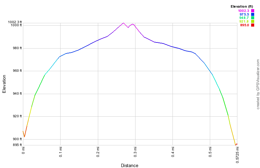
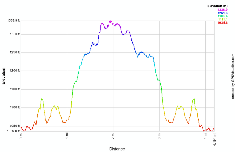 (The image at the left shows the profile of the hike. Remember that all vertical profiles are relative!)
Bearfort Ridge: Surprise Lake from Warwick Turnpike
| Quick Look | ||||
|---|---|---|---|---|
| Difficulty | Round trip | Total climb | Internet Maps | |
| 5.3 mi. | 1000 ft. | AllTrails | ||
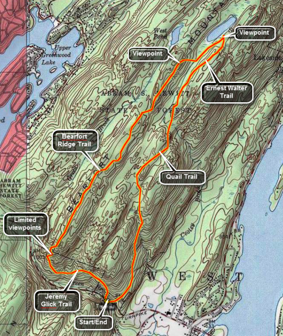 This trail follows Bearfort Ridge and leads to a secluded lake. The lookout from the ridge over Greenwood Lake is limited but nice. The route is challenging as it keeps the hiker on a spine of rock with many ups and downs.
Get on the Warwick-Greenwood Lake Turnpike. Near Greenwood Lake look for White Road that runs south. Just west of the intersection with White Road is a small parking area. If this lot is full there is another parking about a quarter mile west. Just out of the parking area there is a trail junction. Bear left on the white blazed Bearfort Ridge Trail and follow it as it ascends 630 feet in the next mile. Continue to follow the trail as it dips and rises along the ridge. Watch you footing on the rock spine that makes up most of this part of the trail At about 2.55 miles the trail meets the yellow Ernest Walter Trail. Turn right and walk to the shores of Surprise Lake for a nice view. Turn around and look for the orange blazes of the Quail Trail. This trail heads southwest and back to the car. It has its ups and downs for about a mile until at 4 miles it starts a serious downward trend. From here the trail drops over 500 feet in the last 1.3 miles until you are back at the parking area.
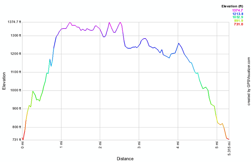 (The image below shows the profile of the hike. Remember that all vertical profiles are
relative!)
(The image below shows the profile of the hike. Remember that all vertical profiles are
relative!)
Bearfort Ridge: Terrace Pond from Warwick Turnpike
| Quick Look | ||||
|---|---|---|---|---|
| Difficulty | Round trip | Total climb | Internet Maps | |
| 4.6 mi. | 1000 ft. | AllTrails | ||
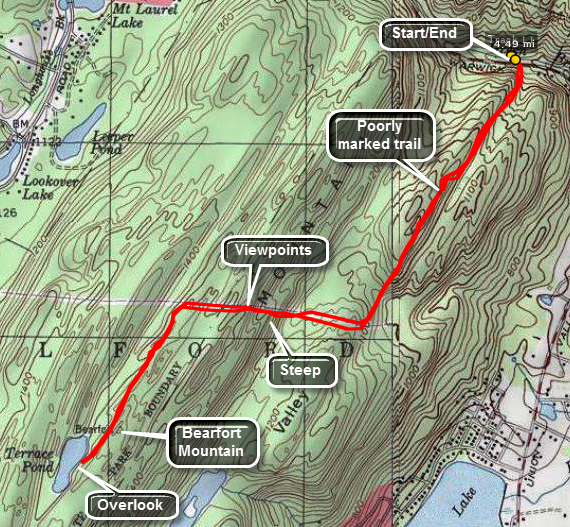 WARNING: This trail is closed as of July 2011 due to an expansion of the Tennessee Gas Pipeline Company's construction project. The new construction bisects the trail. Further construction may threaten even the AT in New Jersey!
This trail leads to a secluded glacial pond and the lookout from the ridge over Greenwood Lake is excellent. The New York City skyline is visible from the highest point. The route is challenging as it keeps the hiker on a spine of rock with many ups and downs and has several STEEP climbs.
Get on the Warwick-Greenwood Lake Turnpike. Near Greenwood Lake look for White Road that runs south. About a quarter mile west of the intersection and up the hill is a small parking area that is more of a pulloff on the north side of the road. Park here and walk across the road to get on the blue Terrace Pond North Trail. The first part of this trail runs through private property and the owners have been kind enough to allow access. For about a mile the trail ascends and the descends. Watch for an almost 90 degree right turn around 1 mile after which the trail drops slightly. In this area you will eventually start to walk UP a power line right-of-way. There are great views to the south and east along the way and the view ahead of what you are going to climb is impressive. In a short .2 miles the trail climbs about 250 feet which is close to a 30% grade! After this, the trail levels off and at 1.6 miles turns sharply off the power line and into the woods. The trail continues up slightly as it follows spines of rock until it meets the white Terrace Pond Circular Trail at about 2.1 miles. Walk to the cliffs on the south shore of the pond for a beautiful view. Above and behind you is an even higher area. This is Bearfort Mountain which is the highest point in Passaic County. You can take the short bushwhack to the summit. There are several informal paths to follow. To get back you may continue around the pond on the Circular Trail or simply retrace the path you took to the pond.If you choose to go around the pond, be aware that the east end can be very wet.
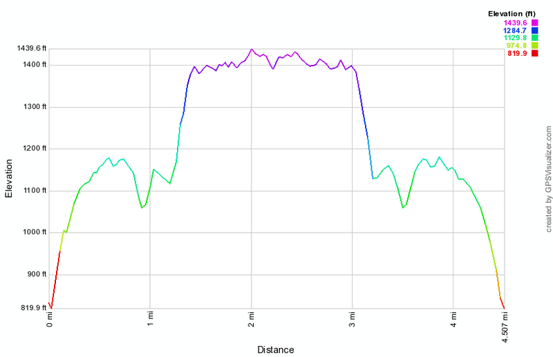 (The image at the left shows the profile of the hike. Remember that all vertical profiles are relative!)
Budd Lake Fire Tower
| Quick Look | ||||
|---|---|---|---|---|
| Difficulty | Round trip | Total climb | Internet Maps | |
| .7 mi | 115 ft | AllTrails | ||
From Route 46 in Budd Lake, NJ take Sand Shore Road north along the east shore of Budd Lake for a little more than 1.5 miles. Turn right on Fire Tower Road. Where Fire Tower Road crosses Lozier Road continue straight across. When the road branches follow the right fork and park at the dead end. Be sure to leave space for vehicles to pass through the gate especially during times of high fire alert. Walk north along the road for about .35 miles to the tower. Take some pictures and then retrace your path back to the car. Budd Lake is the largest fresh water lake in New Jersey so it may be worthwhile to visit the tower during a high fire alert so that you mat climb the tower with permission from the observer.
 (The image at the left shows the profile of the hike. Remember that all vertical profiles are relative!)
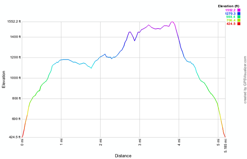
Delaware Water Gap: Buttermilk Falls (NJ)
| Quick Look | ||||
|---|---|---|---|---|
| Difficulty | Round trip | Total climb | Internet Maps | |
| 5.2 mi | 1340 ft | AllTrails | ||
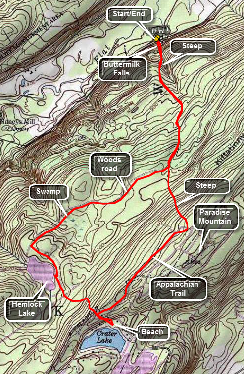
One of the hardest parts of this hike is finding the location of the highest falls in New Jersey. From Route 209 in Dingman's Ferry, Pennsylvania cross the bridge on Route 739 over the Delaware River. Turn right almost immediately on Old Mine Road. Old Mine Road quickly becomes Walpack Flatbrook Road. Stay on this road for a little over 8 miles from the bridge. Mountain Road will be on your left but is poorly marked. The road surface is as poor as the marking and may be impassable for some vehicles at certain times. Drive carefully for about 1.5 miles and park in the parking area on the left. The falls is directly across the road from the parking area. At this point you could return to your car. The hike described here takes in a few more points of interest but is not easy.
From the base of the falls hike up the trail using the wooden steps to access an observation platform about halfway up the falls. Near the top there is another platform which gives limited views to the north. Continue on the trail across a bridge and up the west side of the stream. Hike for about .9 miles and before taking a right on a woods road. This first part of the trail is steep in parts. The next 1 mile of the trail is almost flat and remains woods road for most of the way to the shores of Hemlock Lake. Along the way the trail passes by a pretty beaver pond. At the shores of Hemlock lake turn left on a dirt road and walk by the northern and eastern shore of the lake. The lake is a popular place to swim even though all the "beaches" are rocks. The trail will gain some elevation over the next .75 miles until it intersects the Appalachian Trail. Walk straight ahead across the AT and follow the paths and roads down to the shores of Crater Lake. Local legend says the lake was formed by a meteor impact but it seems entirely too shallow for this to be true. This is another popular bathing area since there is a road on the other side that runs directly to the lake. Return to the At and turn right. As you hike along the AT for the next .8 miles the trail rises only slightly. On your right is Paradise Mountain. Turn left to start to descend back to the junction with the woods road you used earlier. Stay straight ahead at the junction and walk back down the hills and the wooden steps to the parking area.
 (The image at the left shows the profile of the hike. Remember that all vertical profiles are
relative!)
(The image at the left shows the profile of the hike. Remember that all vertical profiles are
relative!)
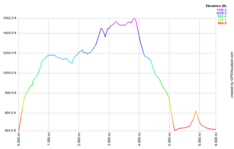
| Quick Look | ||||
|---|---|---|---|---|
| Difficulty | Round trip | Total climb | Internet Maps | |
| 6.5 mi | 1490 ft | AllTrails | ||
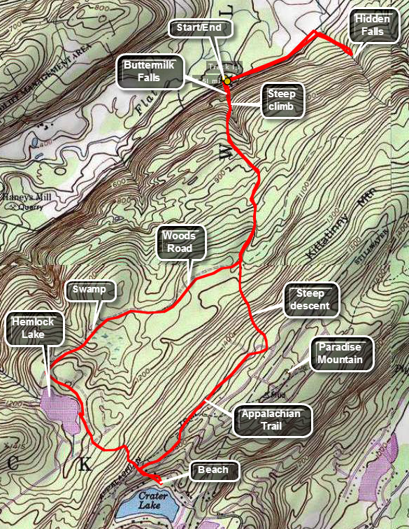
One of the hardest parts of this hike is finding the location of the highest falls in New Jersey. From Route 209 in Dingman's Ferry, Pennsylvania cross the bridge on Route 739 over the Delaware River. Turn right almost immediately on Old Mine Road. Old Mine Road quickly becomes Walpack Flatbrook Road. Stay on this road for a little over 8 miles from the bridge. Mountain Road will be on your left but is poorly marked. The road surface is as poor as the marking and may be impassable for some vehicles at certain times. Drive carefully for about 1.5 miles and park in the parking area on the left. The falls is directly across the road from the parking area. At this point you could return to your car. The hike described here takes in a few more points of interest but is not easy.
From the base of the falls hike up the trail using the wooden steps to access an observation platform about halfway up the falls. Near the top there is another platform which gives limited views to the north. Continue on the trail across a bridge and up the west side of the stream. Hike for about .9 miles and before taking a right on a woods road. This first part of the trail is steep in parts. The next 1 mile of the trail is almost flat and remains woods road for most of the way to the shores of Hemlock Lake. Along the way the trail passes by a pretty beaver pond. At the shores of Hemlock lake turn left on a dirt road and walk by the northern and eastern shore of the lake. The lake is a popular place to swim even though all the "beaches" are rocks. The trail will gain some elevation over the next .75 miles until it intersects the Appalachian Trail. Walk straight ahead across the AT and follow the paths and roads down to the shores of Crater Lake. Local legend says the lake was formed by a meteor impact but it seems entirely too shallow for this to be true. This is another popular bathing area since there is a road on the other side that runs directly to the lake. Return to the At and turn right. As you hike along the AT for the next .8 miles the trail rises only slightly. On your right is Paradise Mountain. Turn left to start to descend back to the junction with the woods road you used earlier. Stay straight ahead at the junction and walk back down the hills and the wooden steps to the parking area.
Turn right and walk about .5 miles down the road. Turn right into the woods on an informal path. Cross over the stream and walk along bank of the small creek for several hundred feet. You should see Hidden Falls at this point. Some nice views of the falls can be had from above but the banks are steep and slippery. Scrambling up the banks is DANGEROUS! It is better to take your pictures from the base of the falls. When you are done, retrace your route back to the car.
 (The image at the left shows the profile of the hike. Remember that all vertical profiles are relative!)
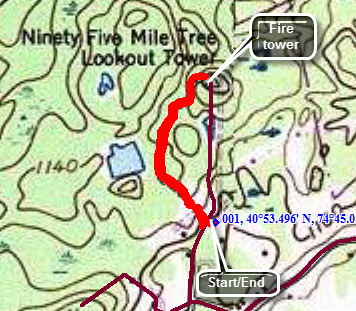
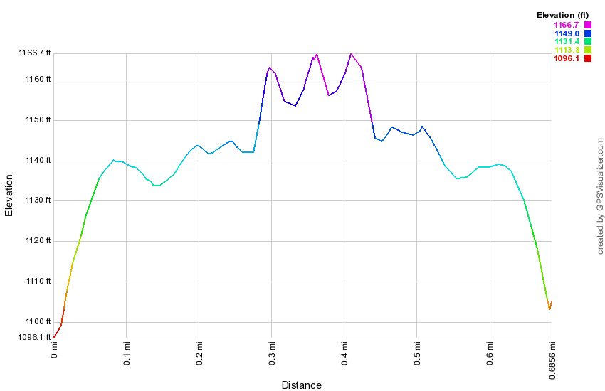
Delaware Water Gap: Culvers Fire Tower
| Quick Look | ||||
|---|---|---|---|---|
| Difficulty | Round trip | Total climb | Internet Maps | |
| 3.3 mi | 800 ft | AllTrails | ||
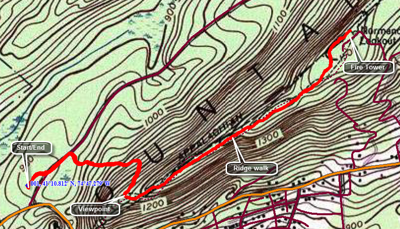
Take Rt 206 south from Milford, PA and watch for the junction with Route 560. Drive 1.7 miles from the junction passing Kittatiny Lake on the right. Turn left on Upper North Shore Road. The road splits almost immediately into Sunrise Highway, a seasonal road, and Upper North Shore Road. Turn right into the parking area. Walk out the far endow the parking area and along Sunrise Highway. Watch for the blazes of the AT in about .25 miles. Turn right into the woods and begin to ascend the ridge on a trail that switches back several times. At the top of the trail there is a nice lookout over Culvers Lake. The trail turns left or northeast from here and follows along the ridge with minimal elevation gain the rest of the way. Around 1.6 miles you will spot a tower ahead but that is the communications tower. Just around the next bend is the fire tower. the official policy is that no one is allowed to climb the towers when an observer I not present. Fortunately, there are some nice views from the ground. To return the shortest way simply retrace your path up to then tower. Several other routes from Stokes Forest are possible and include other viewpoints like Sunrise Mountain.
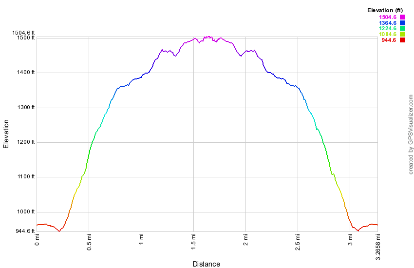 (The image at the left shows the profile of the hike. Remember that all vertical profiles are relative!)
Delaware Water Gap: Mount Tammany
| Quick Look | ||||
|---|---|---|---|---|
| Difficulty | Round trip | Total climb | Internet Maps | |
| 3.2 mi. | 1190 ft. | AllTrails | ||
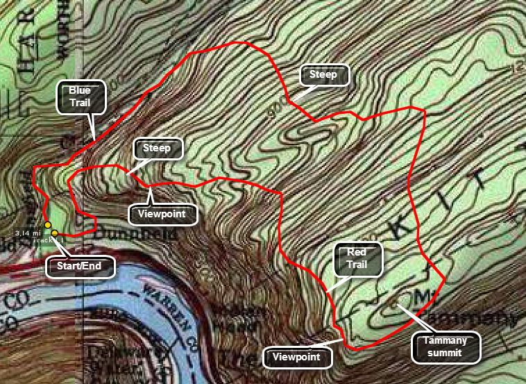
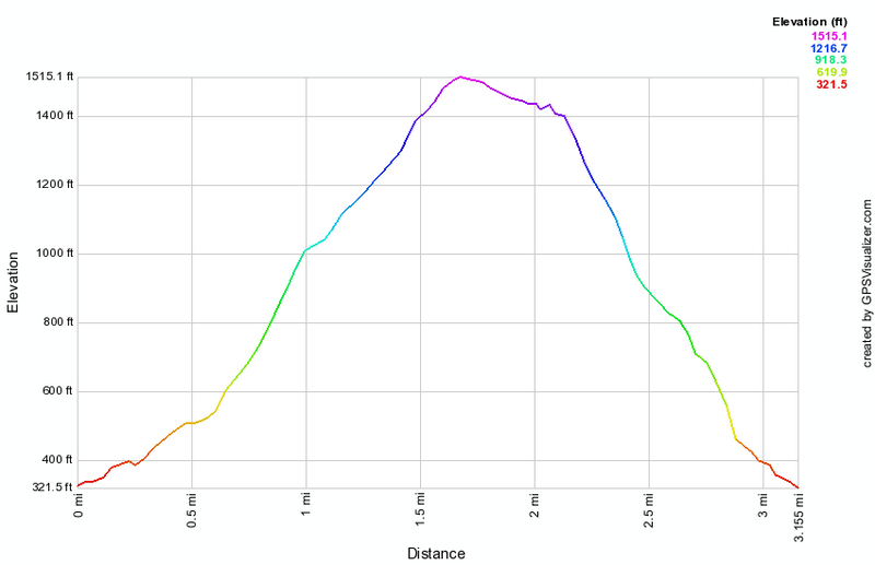
Exit Interstate 80 at the exit for the Kittatinny Point Visitors Center. Pass by the center and under Interstate 80. Park in the Dunnfield Creek parking area to begin your hike. Several routes are available. This one takes you up the Blue Dot Trail and down the Red Dot Trail although the reverse route is also interesting. In the parking area look for the kiosk and then spot the white blazes for the Appalachian Trail. After about .6 miles bear right on the green Dunnfield Creek trail but watch for another quick right onto the Blue Dot Trail. The trail gains about 850 feet over the next mile where it hits the Mount Tammany Fire Road on the ridge. The trail is rocky in many places and is a challenge but never very steep. Hike another .25 miles along the trail/fire road. The Blue Dot Trail ends and the Red Dot Trail begins at an incredible viewpoint on an open rock face. Walking down the rocks can be tricky but the views are even more rewarding.In wet or icy weather remain on the trail at the top where you will still have good views. The lookout allows you to look up and down the river. The descent on the Red Dot Trail is steeper than the ascent and there are some areas where you will have to scramble over rocks. Watch for additional viewpoints on the way down which give you another angle. The Red Dot Trail will return to the parking area but you will have to watch carefully as several informal paths confuse the issue.
 (The image at the left shows the profile of the hike. Remember that all vertical profiles are relative!)
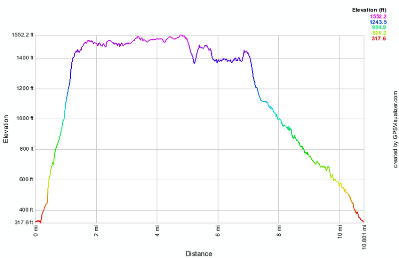
Delaware Water Gap: Sunfish Pond by Tammany Fire Road
| Quick Look | ||||
|---|---|---|---|---|
| Difficulty | Round trip | Total climb | Internet Maps | |
| 10.8 mi | 1944 ft | AllTrails | ||
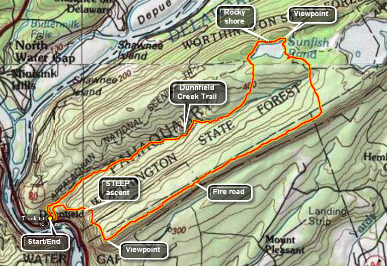
Park at the Dunnfield Creek parking area off I80 just over the New Jersey border in the Delaware Water Gap. Take the Red Dot Trail from the parking lot and get ready for a steep climb! In 1.4 miles from the parking area the trail gains 1130 feet. There are several viewpoints along the trail that look upstream through the water gap. The best reward is the open rock face near the top that acts as a lookout.Walk out carefully onto the rock face to get a good view up and down the river. The Blue Dot Trail begins where the Red Dot Trail ends at the lookout. Walk about .25 miles on the Blue Dot Trail at which point it will turn left and start down off the ridge and back to the parking area. Continue straight ahead on the Tammany Fire Road. This unmarked path stays largely on top of the ridge as it meanders for about 3 miles until it meets the Turquoise Trail to Sunfish Pond. The fire road is relatively easy to follow but there are no markings of any kind. Turn left on the blue Turquoise Trail marked by a cairn but little else. The blazes are few and far between. After about .8 miles or so on the trail it meets and starts to follow a woods road around the pond. Be sure to watch for blazes as the trail bears left to a high point overlooking Sunfish Pond. From this viewpoint head out on the Turquoise Trail which soon ends at the Appalachian Trail. Turn left to go around the pond. This part of the trail is EXTREMELY rocky and hard to walk. Continue on around the lake on the AT. At the southwest end of the lake pick up the green Dunnfield Creek Trail and start to climb a little up to a small ridge. The trail does not climb all the way to the ridge but stays close to the creek as it heads southwest toward the Delaware River. The trail is very rocky and uneven for the first mile but begins to get smoother the further along. The trail follows most of the twists and turns in the shallow creek and you will cross back and forth to avoid the steep banks on one side or the other a number of times. In about 3 miles form the pond, there is a trail junction with the Blue Dot Trail up Tammany. A bridge here crosses the creek near what is sometimes called Dunnfield Falls. The Blue Dot Trail, Dunnfield Creek Trail and the AT all come together in this area. Continue on the AT back to the parking area.
 (The image at the left shows the profile of the hike. Remember that all vertical profiles are relative!)
Glenwood Rd to Route 94
| Quick Look | ||||
|---|---|---|---|---|
| Difficulty | Round trip | Total climb | Internet Maps | |
| 7.7 mi | 1070 ft | AllTrails | ||
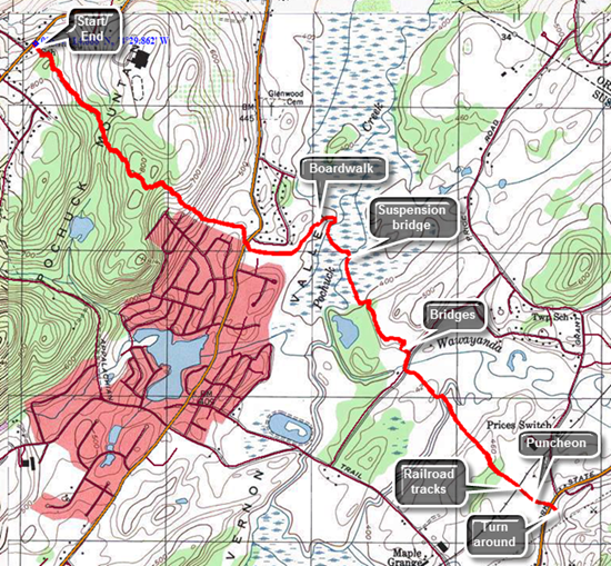
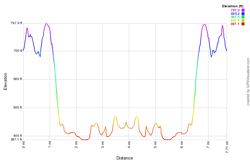
Drive over the New York New Jersey line on the Pulaski Highway which soon become Route 517. Watch for a right hand turn onto Route 565 which is Glenwood Road. Pass Vernon Township High School on the left with a blinking light. About .4 miles after this, the AT crosses the road with a small pulloff on the right. If you reach Glenwood Mountain Road, you have gone too far. Cross the street and walk up the wooden stairs to get on the AT. The first .9 miles of trail heads southeast through some hardwood forest. You will gain a little elevation and then lose it as you pass by Vernon Township High School. You may be able to hear students on the athletic fields and you will cross several paths or ATV tracks. After gaining the top of a small hill, there is a continuous descent for the next .7 miles which results in losing 385 feet to where the trail crosses Route 517. As you reach the road you may find a number of cars parked along the shoulder. The Pochuck Boardwalk is very popular. Cross the road to start the boardwalk. The boardwalk is an impressive feat as it is a sturdy structure that crosses Pochuck Marsh and Pochuck Creek. It stretches about a mile and has a suspension bridge that spans the creek. The boardwalk is two to three feet above the level of the marsh and is supported by steel pipes driven into the underlying strata. Occasional steel cables tether the structure in place. The vegetation along the edges of the walk is usually trimmed back in all places where it is possible. The boardwalk stops where the trail enters the woods and then begins on the other side. Watch for red-winged blackbird, turtles, snakes and many other animals. At 2.3 miles you will approach Pochuck Creek which is spanned by a suspension bridge. This is a truly remarkable structure which stands at least 15 feet above the level of the creek. It is well-anchored on both ends and has sturdy cables which hold the deck in place. Continued along the boardwalk until it enters the woods on the other side of the swamp. The trail remains flat and crosses a small stream on a bridge and then crosses Wawayanda Creek on a larger bridge. You will come to a path which looks like a rail trail and is marked as Canal Road on most maps. Turn right and walk a few feet to where the trail turns off to the left. There are some wet areas between you and Route 94 which are crossed by puncheons. At 3.7 miles cross the Conrail tracks. Stiles are provided to cross the fencing that was erected on either side of the tracks but the parade of hikers has pushed the fence aside making them unnecessary. On the other side of the tracks is an open field with Route 94 just beyond. The field can be pretty wet and puncheons stretch across it almost to the road. On the other side of the road is Wawayanda Mountain. When you reach the road, you may turn around or cross to the parking area on the other side and read the sign board. When you are ready, turn around and reverse your route to get back to the car.
 (The image at the left shows the profile of the hike. Remember that all vertical profiles are relative!)
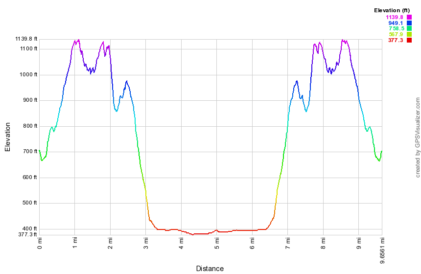
Glenwood Rd to Wallkill Refuge
| Quick Look | ||||
|---|---|---|---|---|
| Difficulty | Round trip | Total climb | Internet Maps | |
| 9.7 mi | 1960 ft | AllTrails | ||
Drive over the New York New Jersey line on the Pulaski Highway which soon becomes Route 517. Watch for a right hand turn onto Route 565 which is Glenwood Road. Pass Vernon Township High School on the left with a blinking light. About .4 miles after this, the AT crosses the road with a small pulloff on the right. If you reach Glenwood Mountain Road, you have gone too far. The first .1 miles is a slight downhill and there are some puncheons over marshy ground before an ascent of about 1 mile. At about .6 miles the trail we crosses a dirt road labeled Louemma Lane. Continue to hike to the top of a small hill gaining almost 500 feet in the first mile. After a slight drop, you will again gain about the same elevation and come to a lookout. The viewpoint is limited but you can see what looks like a marsh below. This is the Wallkill National Wildlife Refuge. The trail travels mostly through hardwood forest and is a mixture of packed dirt in some spots and rocky traverses in others. From the viewpoint the trail starts a gentle descent which turns into a steeper, rockier descent a little further on. You will lose over 500 feet of elevation in just .6 miles. The trail crosses Lake Wallkill Road and then runs about .5 miles through a rather damp area. Puncheons elevate the trail out of the marshy ground for a good part of this distance. At the end you will come to a wide "road" on the edge of a marsh. The trail turns left here and follows an old railroad grade for .25 miles before turning right. Continue around the marsh and after about .5 miles make another right turn. At about 5 miles make another right turn onto a path that parallels Oil City Road. The path along the road is about .5 miles. At the end make a right turn back onto the railroad grade. In another .5 miles you will be back at the spot where the AT comes out of the woods. Turn left and head back toward the car. Most of the climbs are easier than they were as descents. There isn't too much remarkable along the trail but you might stop at the viewpoint again. Return to the car by retracing your route from earlier
 (The image at the left shows the profile of the hike. Remember that all vertical profiles are relative!)
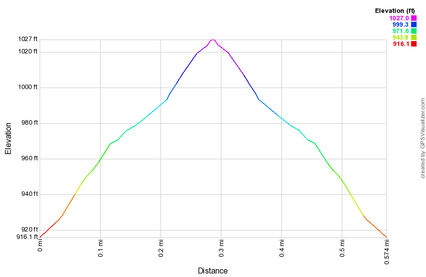
Greystone Fire Tower
| Quick Look | ||||
|---|---|---|---|---|
| Difficulty | Round trip | Total climb | Internet Maps | |
| 0 mi | 0 ft | AllTrails | ||
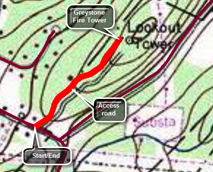
This was a hard tower to find but an easy one to hike. There is an access road that goes directly to the tower. The map and profiles here show parking at then of the access road but this is not really necessary. At 92 feet Grid is the tallest tower in New Jersey. From Route 10 heading east toward Denville turn right on Miller Mountain Road. After only .25 miles, bear right on Zeek Road. Follow Zeek Road until it ends at Casterline Road. Turn right on Casterline and then right again on the unmarked access road. Drive to the end of the road and park near the tower. You will have to visit this tower during fire season as it is fenced and cannot be climbed unless an observer is present.
 (The image at the left shows the profile of the hike. Remember that all vertical profiles are relative!)
High Point: Lake Rutherford
| Quick Look | ||||
|---|---|---|---|---|
| Difficulty | Round trip | Total climb | Internet Maps | |
| 6.8 mi | 920 ft | AllTrails | ||
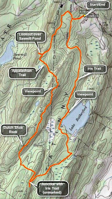
Park in the parking area off Route 23 just south of the park office and maintenance buildings. Find the white blazes of the Appalachian Trail and begin to hike southwest. The trail has its ups and downs and within about 1 mile the Blue Dot Trail turns off to the right. This trail descends steeply to Sawmill Lake which has a campground area. Walk down the trail until it starts the steep descent. At this point there is a great view to the west over the lake. Back on the main trail you will ascend top a small ridge at about .75 miles which has some nice viewpoints to the west and east. The trail now descends to around 2.75 miles to the area near Dutch Shoe Rock. A side trail leads left to a shelter and there are several viewpoints in this area. The trails starts a steep descent for about .25 miles and then regains some of that elevation to about 3.5 miles where the At and the red Iris Trail run together briefly. The trail junction is poorly marked but you should make an almost 180 degree turn to get on the Iris Trail to head northeast. This trail runs along the base of the ridge and has few views. At 4.4 miles watch for a sharp left where the trail turns north to avoid a restricted area. At around 5 miles the trail passes by Lake Rutherford and there are several spots to get views down to and across the lake. From the lake the trail starts to climb back up to the elevation of the parking area. The red Iris Trail ends at the AT and another yellow trail begins. Be sure to turn right on the AT to get back to your car.
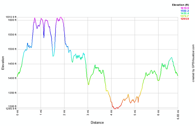
(The image above shows the profile of the hike. Remember that all vertical profiles are relative!)
Long Pond Ironworks
| Quick Look | ||||
|---|---|---|---|---|
| Difficulty | Round trip | Total climb | Internet Maps | |
| 4.4 mi. | 745 ft. | AllTrails | ||
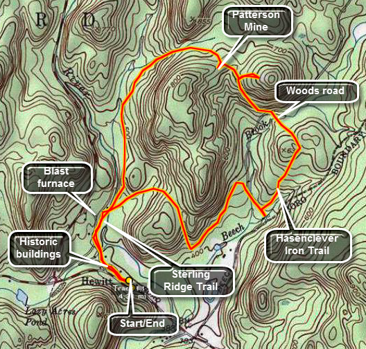 This trail in Hewitt, New Jersey traces the Hansclever Iron Trail near the Monksville Reservoir. It is rich in history.
Take the Greenwood Lake Turnpike east from the intersection with Lakeside Road at the south end of Greenwood Lake. Drive a little more than three miles east and park at the visitor's center for the Long Pond Iron works. There are some groomed paths to the left of the visitor's center that wander between some historic building. Watch for thee blue blazes of the Sterling Ridge Trail which runs in conjunction with the Highlands Trail. At about .45 miles the trail turns right and crosses the Wanaque Reservoir on a bridge. Before making the turn be sure to inspect the ruins of the iron furnaces that dates back to the American Revolution! When you cross the river bear to the right on the yellow Hasenclever Iron Trail. This trail follows one of the routes used to transport iron ore from the mines to the furnace. Along the trail you will find placards explaining some of the historic spots. At abbot miles you will walk1 up a hill and a woods road turns to the left. Make the turn and continue northwest on the road until about 2.5 miles. In this Rae you will find the Patterson Mine. Watch for "rusty" rocks which are the tailing from the mines. There will be one or two shallow pits on the left of the road. On the right side of the road there are two or three deeper pits and a trench. Be careful around these since they are often filled with water and the sides are unstable. Back on the road continue to walk downhill until 2.8 miles when the woods road meets the Sterling Ridge Trail. Turn left on the trail to get back to the parking area. Along the way the trail parallels the Wanaque River which is a popular swimming area.
 (The image at the left shows the profile of the hike. Remember that all vertical profiles are relative!)
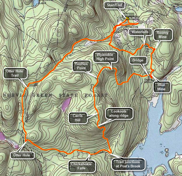
Norvin Green State Forest: Lower Trail
| Quick Look | ||||
|---|---|---|---|---|
| Difficulty | Round trip | Total climb | Internet Maps | |
| 7.2 mi | 1544 ft | AllTrails | ||
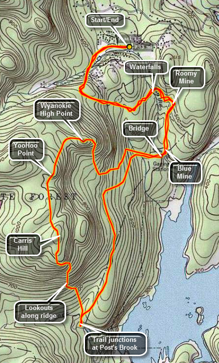
The hiking trails in Norvin Green State Forest in northern New Jersey are many and varied. The area contains several mines, great views from various high points and some seasonal waterfalls. By combining trails in different ways many different hikes can be constructed with varying lengths and degrees of difficulty. Park at the parking lot at the Weis Education Center on Snake Den Road. The first part of the hike winds its way through the recreational area of the park and around a rather unique pool. The pool is formed from a natural pool in the stream and has been fenced and "improved" for swimming. Follow the green Otter Hole trail along the stream and across a bridge until you reach a trail junction. Take the yellow trail Mine Trail toward the Roomy Mine. The yellow Mine Trail climbs a small hill and then winds through some nice open woods. There is a seasonal falls along the way formed on Blue Mine Brook. Around .9 miles look for a new orange cutover trail to get to the Roomy Mine. This trail may not be marked on some maps. The previous access from Snake Den Road has been closed by the owner of this private property. The orange trail follows an old mine road to the entrance of the Roomy Mine. The signs outside the mine caution that the mine is closed and should not be entered due to a resident bat population. Disturbing the bats while they are hibernating can seriously affect their fat stores which may make it impossible for them to complete their hibernation. Also, there is a concern about the white nose fungus which can be transmitted from mine to mine and cave to cave. Stay outside the mine to take pictures. You may venture up the slippery rocks to look down into the airshaft near the entrance! Back on the trail. the orange trail soon rejoins the yellow and red dot trails. It is a short walk to the Blue Mine. This mine is almost completely flooded and it is hard to get an idea from the adit how big it was. One look at the extensive tailings piles near the mine gives an indication that TONS of material were removed. Cross the bridge and take the red dot WCI, blue Hewitt Butler and Highlands trails as they start a short but steep climb to the Wyanokie High Point at around 2.5 miles. Just over the bridge is the stone foundation remains of some building from long ago. The trails to the High Point switchback several times but the elevation gain is not that great. The High Point seems so high since it has a much greater elevation that the surrounding terrain although it may not be the highest point in the park! The trail levels near the top and there are some nice views. The Wanaque Reservoir dominates the view to the east while small villages dot the valleys and hillsides in the other directions. Continue the final climb to the very top over bare rock with only a few scrub pines. The view from here is 360 degrees and a short walk around the top allows photographing the landscape without any intervening vegetation. Following the Hewitt Butler and Highlands Trails as they head toward Yoo Hoo Point. The trails descend rather steeply off Wyanokie High Point, wander through some woods and then ascend again to Yoo Hoo Point. Along the way the red WCI trail leaves to the right but stay straight on the trail. Yoo Hoo Point is named for its close proximity to the Wyanokie High Point. The two are close enough that you could yell to another person on the other viewpoint and be heard and seen! Continue on to the trail junction with the yellow Carris Hill Trail which actually starts almost at the top of Carris Hill at about 3.25 miles. Carris Hill may be the highest spot along these trails. At the top of Carris Hill follow the yellow Carris Hill Trail which works its way along a ridge to some nice lookouts directly to the south and east. As you continue the views from the southern tip of the Carris Hill Ridge were very nice! Descend Carris Hill toward Posts Brook and a trail junction with The Posts Brook and Lower Trails at 4 miles. Take the white Lower Trail as it heads north. The trail was an Eagle project and undulates slightly but is the easiest way back to the parking area.Watch for the red WCI Trail at 5.3 miles and turn right retracing your path passed the Blue and Roomy Mines. From here follow your earlier route in reverse back to the Weis Center.
 (The image at the left shows the profile of the hike. Remember that all vertical profiles are
relative!)
(The image at the left shows the profile of the hike. Remember that all vertical profiles are
relative!)
Norvin Green State Forest: Otter Hole
| Quick Look | ||||
|---|---|---|---|---|
| Difficulty | Round trip | Total climb | Internet Maps | |
| 8.3 mi | 1677 ft | AllTrails | ||
The hiking trails in Norvin Green State Forest in northern New Jersey are many and varied. The area contains several mines, great views from various high points and some seasonal waterfalls. By combining trails in different ways many different hikes can be constructed with varying lengths and degrees of difficulty. Park at the parking lot at the Weis Education Center on Snake Den Road. Walk out of the driveway of the Weis Center and turn RIGHT. The trail access from Snake Den Road to the left has been closed by the owner of the property. The problem with the trails in the park is that there are quite a few and many run together in different places. All are well marked with paint blazes and some even have signs pointing to attractions. Watch for signs for the Highlands Pool which is a natural pool that has been developed for use by adding a fence, a cement apron and a lifeguard. You should now be on the yellow Mine Trail walking beside a stream and through a hardwood forest. At the trail kiosk continue on the yellow trail which will take you toward the Roomy and Blue mines. Along the way the trail passes above Wyanokie Falls. Continue on the yellow trail until the orange blazed Cutoff Trail bears to the left on an old, reinforced mine road which leads directly to the Roomy Mine. The Roomy Mine can be entered through a low and narrow opening but signs warn against it because of the white nose disease that is decimating the bat population. You may walk up the hill to a shaft that looks down into the mine. Follow the orange trail until its junction with the Red Dot and yellow Mine Trails. Turned left or south and after a short walk you will be at a bridge over Blue Mine Brook at the junction with the Highlands Trail. The mine entrance is straight ahead just after the bridge. On your left will be some very large tailing dumps. The Blue Mine is completely flooded and it is impossible to see much in the dark opening. Returning to the Bridge and the Highlands Trail which runs concurrently with the red WCI Trail. Stay on the trail passing junctions with the yellow Mine Trail and the white Lower Trail. A short but steep stretch of trail climbs toward the Wyanokie High Point at 2.95 miles. This is a bald half dome with 360 degree views dominated by an unobstructed view of the Wanaque Reservoir. Continue on the Highlands Trail as it runs along with the blue Hewitt-Butler Trail. The descent from the High Point is pretty dramatic but not too difficult and is followed by a brief descent and some flat section. It then climbs again to another high area called Yoo-Hoo Point. I suspect it got its name from its close proximity to the High Point. It is close enough to yell a greeting to someone standing there! Start to descend down the other side and then ascend toward Carris Hill. At the junction with the yellow Carris Hill Trail, bear left to follow this trail. The trail flattens out and opens up onto an area of bare rock with some trees and a large glacial erratic. There are views to the south especially as you descend the hill. The descent to Posts Brook is steep in some parts until it cuts to the right across some open rock and continues behind the large rock outcrop. Walking out onto the rock gives of the best views in the park. The Wanaque Reservoir is just below with the dam clearly visible with some nice islands and arms of land jutting out into the water. Walk behind the rock and continue your descent toward the Posts Brook Trail. Turn right on the Posts Brook Trail at 4.4 miles and approach Chikahoki Falls in another .3 miles. The trail follows closely along the brook until it reaches a small pool. Water runs over a large rock outcrop and into the pool forming the falls. The falls vary seasonally from a trickle to crashing water. Continue on the Highlands and Hewitt-Butler Trails to Otter Hole where there another small waterfall. Walk passed the green Otter Hole Trail and continue down the blue trail to Otter Hole at 5.75 miles. Return to the green Otter Hole Trail and turn left to head north. There are a few lookouts along the way but none have much of a view. The trail ascends for the next 1 mile and then starts a descent for the next 1.45 miles. It passes by the Highlands Pool and leads back to the Weis Center.
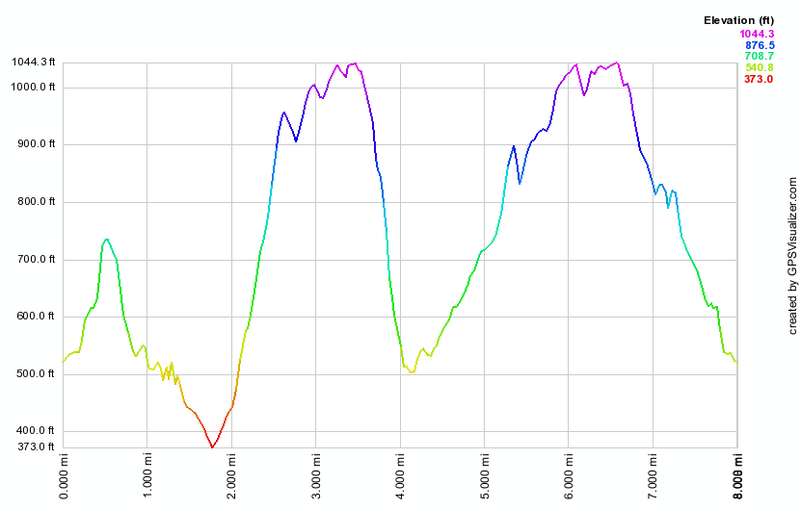 (The image at the left shows the profile of the hike. Remember that all vertical profiles are relative!)
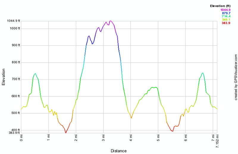
Norvin Green State Forest: Wyanokie High Point and the Mines
| Quick Look | ||||
|---|---|---|---|---|
| Difficulty | Round trip | Total climb | Internet Maps | |
| 4.4 mi | 1053 ft | AllTrails | ||
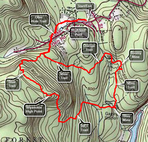
The hiking trails in Norvin Green State Forest in northern New Jersey are many and varied. The area contains several mines, great views from various high points and some seasonal waterfalls. By combining trails in different ways many different hikes can be constructed with varying lengths and degrees of difficulty. Park at the parking lot at the Weis Education Center on Snake Den Road. Walk out of the driveway of the Weis Center and turn RIGHT. The trail access from Snake Den Road to the left has been closed by the owner of the property. The problem with the trails in the park is that there are quite a few and many run together in different places. Not all are well marked with paint blazes but there are some signs pointing to "attractions". Watch for signs for the Highlands Pool which is a natural pool that has been developed for use by adding a fence, a cement apron and a lifeguard. Walk passed the pool and turn left into the woods to follow the green Otter Hole Trail. The trail is rocky and can be difficult to hike especially on snowshoes. At .45 miles cross the extension of Snake Den Road and continue straight ahead on the blue HB trail toward the Wyanokie High Point. The trail to this point ascends very gently. The blue trail begins a more serious ascent with a grade approaching 15%. Ascend to a nice viewpoint with a single glacial erratic. Continue on the trail as it loops around and heads toward the High Point. There are several lookouts along the way but the view from the High Point is best. You may wonder which place is the High Point but you will know it when you get there! After descending a little you will see a huge, rocky mass ahead. Walk the trail to the base and find a sign labeled "High Point". Ascend a narrow path and climb over some open rocks to the High Point. The view is beautiful and largely open in all directions. The Wanaque Reservoir is clearly visible below to the east. It may be a little difficult to find the red WCI Trail which is aligned with the Highlands Trail at this point. Walk to the east towards the reservoir and down the open rock to the left. You should soon be able to pick up blazes and the trail. The trail is much easier to follow when there is no snow on then ground. By 1.9 miles you will have completed the descent from the High Point and the red trail makes a sharp turn to the right. Follow the trail passing by a white trail on the right. Soon a yellow trail appears on the left which is the quickest way back to the car. Continue straight ahead on the red trail which leads the Blue Mine. At 2.25 miles cross a stream on a small bridge and turn right to visit the Blue Mine which is one of the numerous abandoned iron mines found in northern New Jersey. The mine itself is mostly underwater with only the initial adit exposed. Headed north on the yellow and red trails and where the trail spilt stay to the right on the yellow trail. At 2.6 miles turned left on the orange trail which leads to the Roomy Mine. The walk to the Roomy Mine at 2.8 miles is just slightly uphill. Signs outside the Roomy Mine warn hikers to stay out of the mine from September 15 to April 15 to protect the bats which hibernate there. Continue along on the orange trail. The trail that leads directly out to the Weis Center has been closed by the landowner so be careful to followed the orange trail as it leads out to the yellow Mine Trail. Turn right on the yellow trail at 3.1 miles and descend slightly to cross a small brook. From this point the yellow trail begins to ascend a small hill. The uphill is only a 13% grade and lasts for about .3 miles. At the top of the hill cross a stream with a small waterfall and a little farther along turn right onto the blue trail. Descend the hill to Snake Den Road and continue across the road on the Green Otter Hole Trail. Walk down the trail along the brook and pass the Highlands Pool retracing your route from earlier back to your car.
 (The image at the left shows the profile of the hike. Remember that all vertical profiles are relative!)
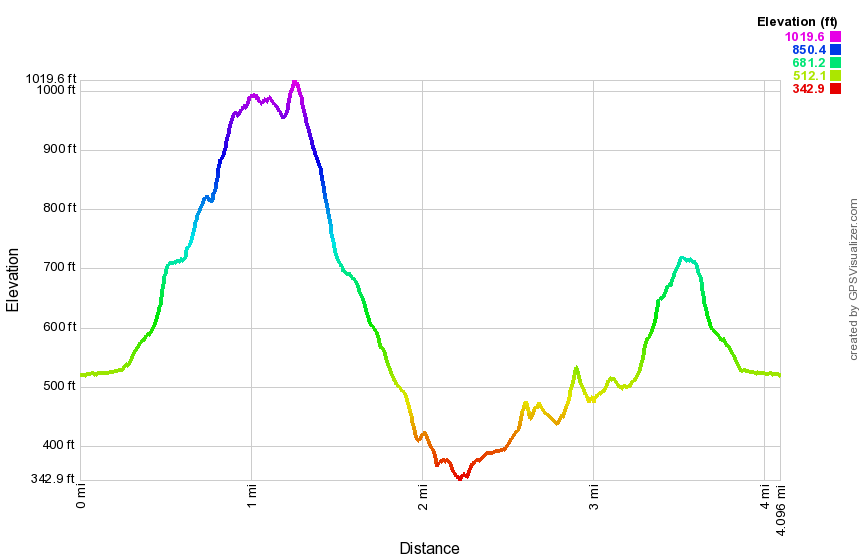
Pyramid Mountain
| Quick Look | ||||
|---|---|---|---|---|
| Difficulty | Round trip | Total climb | Internet Maps | |
| 4.8 mi | 844 ft | AllTrails | ||
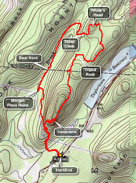
From New Jersey Route 23 turn south and west on Boonton Avenue. Drive 4 miles passing the Taylortown Reservoir on the right. Park at the parking lot on Boonton Ave. just south and west of the Taylorsville Reservoir. Walk to the northwest corner of the parking lot and look for the kiosk. The blue Menenm Trail begins behind the kiosk and heads north. At .2 miles the trail crosses a brook and shortly after a yellow trail comes in from the right. Stay on the blue trail and start an ascent that crosses under some power lines. At .47 a white trail comes in from the left but stay on the blue trail. At .54 miles bear right on Red Trail South and descend to Stony Brook at just less than 1 mile. Turn left on the white trail and walk about 50 feet to inspect the ruins of Morgan Place. Turn around and continue straight ahead on the white trail until a trail junction with the Blue and yellow trails at 1.3 miles. At this junction is Bear (Bare) Rock. This is a huge boulder which may be the biggest in New Jersey. Native Americans used shelters on both sides of the rock. After inspecting this boulder, continue straight ahead on the blue Mennen Trail heading northeast. At 1.9 miles turn sharply right onto a red-white trail and after a short walk merge onto the Red Trail North and make a short, steep ascent to the ridge. At the top of the climb at 2.2 miles is Whale Head Rock and just after that Eagle Cliff. The trail undulates for the next .4 miles until it meets the white Kinnelon-Boonton Trail at 2.8 miles. Turn right and continue on this trail for about .4 miles until you come to Tripod Rock. This is a 150+ ton boulder that sits perched atop three smaller stones. A controversy has developed over whether this is a natural or man-made occurrence! The trail ascends some until at 3.3 miles a side trail on the right leads to Lucy's Overlook. Get back on the main trail and ignore any side trails along the way. The trail markings turn to blue and you should follow them back to the parking lot. At 4.0 miles a side trail leads to an impressive lookout and the highest point on the trails. It is worth the side trip. From here the trail drops steeply to the trail junction where you turn left to get back to the car.
 (The image at the left shows the profile of the hike. Remember that all vertical profiles are
relative!)
(The image at the left shows the profile of the hike. Remember that all vertical profiles are
relative!)
Ramapo Fire Tower
| Quick Look | ||||
|---|---|---|---|---|
| Difficulty | Round trip | Total climb | Internet Maps | |
| .6 mi | 110 ft | AllTrails | ||
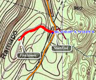
From Ringwood head south on the Greenwood Lake Turnpike which is also known as Ringwood Avenue. Turn left on Skyline Drive and continue for about 2.6 miles. Pull over at the end of a road marked as "Private Driveway" across the road from a gated access to the gas pipeline. Park away from the gate. Walk up the driveway for about .3 miles to the tower. If an observer is present get permission to climb the tower. There are excellent views of the Wanaque Reservoir to the west. Turn facing east and you will see a great view of the New York City skyline. The skyline is clearly visible without a camera but a zoom lens helps. Walk back to your car when you are done.
 (The image at the left shows the profile of the hike. Remember that all vertical profiles are relative!)
Ramapo State Forest: VanSlyke Mansion
| Quick Look | ||||
|---|---|---|---|---|
| Difficulty | Round trip | Total climb | Internet Maps | |
| 9.6 mi | 1928 ft | AllTrails | ||
This hike has a little something for everyone. There is the ruins of the VanSlyke mansion in the Ramapo State Forest along with Matapan Rock, Camp Glen Gray, the Millstones and a paleo-Indian rock shelter.
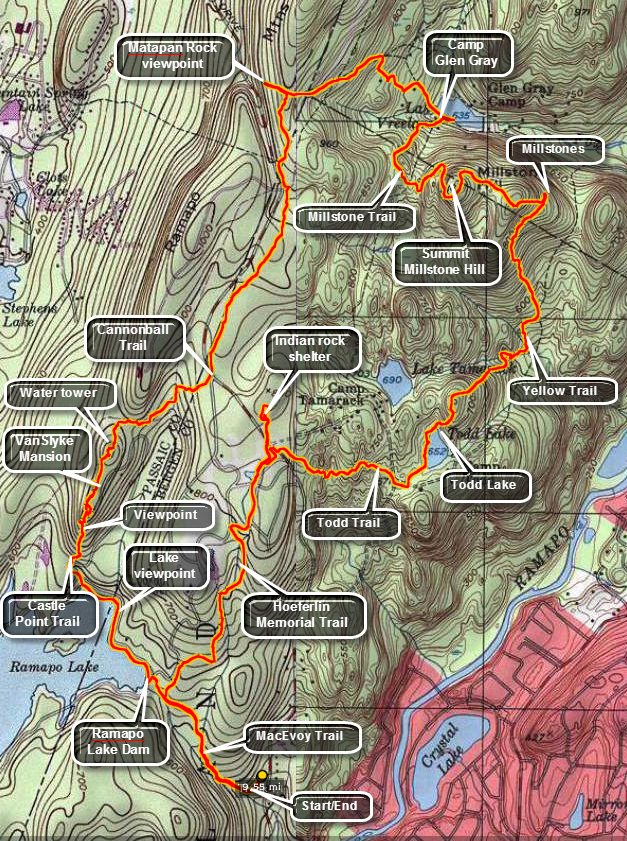
Get off I287 at exit 57 and head north on Skyline Drive. Park at the first parking lot on Skyline Drive. The parking lot see a lot of use and can be very rough. Start your hike on the blue MacEvoy Trail which gains some elevation as it parallels what a stream or stream bed depending on the amount of rainfall. The first .6 miles of the trail is rocky with roots and a 200 foot elevation gain. Pass by trail junction with the white Todd Trail and the yellow Hoeferlin Memorial Trail. You will arrive at the shore of Ramapo Lake and join a paved and completely flat road. There is a dam on the lake and found a private inholding with lake rights in the middle of the state forest. The inholding has the name "Bear Run" and the house and grounds are impressive! At the north end of the lake there is a junction with the white blazed Castle Point Trail and the white on red C Cannonball trail. Turn north on the Castle Point Trail and stay on it when the two trails split almost immediately. Over the next .3 miles the Castle Point Trail rises about 250 feet and there are several viewpoints off the trail which give excellent views of Ramapo Lake to the south and the Wanaque Reservoir to the west. There is a rock outcrop near the top of the trail and a stone wall with mortar. Hop up and over the wall to the grounds of the VanSlyke Mansion! Several sites on the Internet have the history of this mansion which is roughly contemporary with the Cornish Estate near Beacon and the ORAK Mansion in Harriman Park. They are all evidence that there were always those who had more money than others and weren't afraid to spend it. It is easy to imagine the original view unhindered by the current trees. A long road and driveway leads up to the mansion and is still in good shape. It is obvious that fire played a part in the demise of the estate as the remaining woodwork shows signs as does some of the stone. There is a large brick chimney, a few ceramic tiles and a covered buggy/car port. Get back on the main trail and watch for pipes that run to the water tower. There will be a cement structure on the left with pipes, valves and stairs. This was once the swimming pool! There is another viewpoint along the way and then the water tower. The stone structure of the tower is largely intact and is impressive. There is an entrance on the east side and inside there are still some wooden supports and a wooden "ceiling". There is no tank to be seen but you may notice several long iron "cables" lying on the ground which served as "hoops" for a wooden "barrel" on the top of the tower. The tank was filled by rain water and gravity allowed the water to feed downhill to the swimming pool and house. When you are done exploring, start down off the ridge and find the coaligned Hoeferlin Memorial and Cannonball Trails as they cross over Skyline Drive at 2.4 miles. The trails head north toward Matapan Rock. Like many of the trails in New Jersey, these trail are never very far from a road or at least the noise from a highway. At one point the trails descend into an area where there are fences from a utility company. Keep a careful eye on the blazes as they all but disappear. In about a mile from crossing Skyline Drive, you will come across the red blazed Matapan Rock Trail. Turn right or west and walk out to this open rock face. The views are extensive but take in mostly large houses on the opposing hills and in the valleys below. Head back on the Matapan Rock Trail toward Camp Glen Gray and Lake Vreeland. The blazes here can be confusing. As the red trail ends you should find an orange trail. If the orange blazes are absent, turn right on a woods road in the direction of the camp. The buildings of the Boy Scout camp begin to show up and then shore of the lake. The lake is used by the boy scouts but is also open to the public and is often crowded. Follow the orange trail SOUTH until it intersects the white Millstone Trail. Turn left and follow the trail over Millstone Hill. There are several glacial erratics on the way to the summit just .7 miles from the lake. As you descend the next .3 miles you will came to a trail junction and a sign that says "Millstones". There are several worked stones that look as if they might have been destined to be small millstones. What is not clear is why they are in this area. Turn to the south on the yellow blazed Yellow Trail. The trail wanders up and down over some hills and has several switchbacks before Todd lake which is another small pond with lily pads and frogs. At the white Todd Trail turn right or west to follow the Todd Trail to Skyline Drive and the junction with the yellow Hoeferlin Memorial Trail. To visit the Indian Rock shelter DO NOT cross the road but walk down the shoulder of Skyline Drive until you pick up the trail. You will soon see a sign painted on the rocks pointing the way. The "shelter" is not too large with simply a rock overhang. All the artifacts have been removed. This must have been a very temporary shelter as it is very exposed. You can walk up the hill along the rock outcrop to look for other shelters. Followed the yellow trail back to the road and cross Skyline Drive. Continued to follow the trail until it ends at the blue MacEvoy Trail where you should we turn left or east and head back to your car.
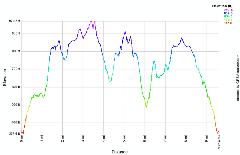 (The image at the left shows the profile of the hike. Remember that all vertical profiles are relative!)
Ramapo State Forest: Ringwood Manor
| Quick Look | ||||
|---|---|---|---|---|
| Difficulty | Round trip | Total climb | Internet Maps | |
| 3.1 mi | 375 ft | AllTrails | ||
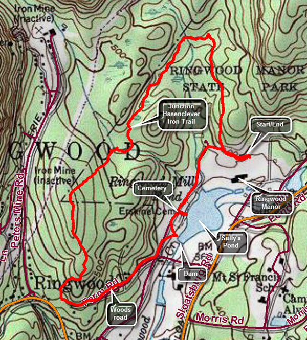
This hike has a little something for everyone including a visit to a historic mansion and the chance to walk around the grounds plus a hike on the property with a visit to a pond and a cemetery. I highly recommend a tour of the manor house first followed by a walk around the grounds and a hike on the loop trail. Take State Route 17 to exit 131 at Harriman. From take Route 17 south through Tuxedo to the village of Sloatsburg. Turne right on Sterling Mine Road and continued until the sign for Ringwood Manor on the right. Drive in the entrance stopping to pay the parking fee at the gate. Walk over to the park office in the manor house and pay an additional fee for the tour. While waiting for the tour stroll around the grounds and the gardens. On the front lawn there are some interesting articles. There is a large chain which is supposed to be from the chain use to block the Hudson River during the Revolution but it is not. There is a Civil War era mortar with an iron base which made it sturdier than those made with a wooden base. There is also a small cannon from the USS Constitution, Old Ironsides. The Ringwood area produced much of the iron for the American colonies throughout the Revolution and after it as well. The once belonged to Robert Erskine who was the cartographer for Washington during the Revolution. After his death, the land was sold to the Ryerson family who built a modest 10 room house in 1810 and continued to mine iron. This part of the house still stands. In 1853 the 19,000 acres of land was purchased by Peter Cooper and this included the Ringwood Manor area. Cooper bought the land to exploit the iron mining and to add it to the holdings of the very successful Cooper Hewett Company. At some point Mrs. Hewett decided to expand the existing house starting in 1864 until it had over 50 rooms and more than 20 fireplaces. Her hand in the design can be seen in most of the rooms as Mr. Hewett had a say in only three of the rooms! The Hewetts also improved the grounds of the manor with gardens. The house was lighted by gas lamps been after electricity became popular. At one time the family owned 40 custom made carriages of different types. Photography is not allowed inside the house. The tour includes the rooms of the first and second floors. The building from the outside is not that impressive but the inside is magnificent. Much of the building and the furnishing are original as are the numerous collections the family accumulated. The guides are very informative about the house, the grounds and the people who lived there. It is definitely a place to visit and go back to visit again. The family donated the house and grounds to the State of New Jersey in 1938. The tour lasts almost exactly and hour an 15 minutes.When you are ready to hike, walk to the back of the manor house to a gate in the fence. Walk through the gate and to the left following the blue blazes. Head west until the blazes direct you to turn right or north at .1 miles. The trail starts uphill gently as a wide and almost flat trail. Pass by some very large trees and at .25 miles the white connector trail heads off to the right. Stay left on the blue trail. At .5 miles the trail heads west and then at .7 miles it turns southwest. Cross a couple of small streams and then approached the area where the yellow Hasenclever Iron Trail crosses the blue trail. This trail connects many of the iron mines in northern New Jersey and there is one marked on the map. Just before the point where the trail crosses there is a pit that is not marked on the map. It looks very much like a small mine except there are no tailings. Continue along the main trail to 1.15 miles where the yellow trail crosses. Just beyond this point cross a larger stream after which the trail runs parallel to the stream for a short distance. It then turns more to the southwest and begins to climb. At 1.55 miles the trail reaches the highest spot and begins to descend and head due south. The trail is rocky in places which makes walking difficult. At 1.9 miles the trail makes a loop so that at 2.1 miles it heads northwest on a woods road. The road continues to descend and at 2.5 miles breaks out of the trees. There is a pond off to the right. Walk over to the pond which has a rather substantial stone dam. On the map it is labeled as Sally's Pond after one of the Hewett children but it served as a mill pond. Walk back up toward the road and to a cemetery on the right. There are two graves surrounded my an iron fence. These are the graves of Robert Erskine and one of his workers. Walked down toward the shore of the pond and to find the graves of some of the Hewett family. Abram and Sarah Hewett are buried in Green-Wood Cemetery in New York City as he was mayor and a three term congressman. Continue back to the point that you started on the blue trail and from there walk back to your car. As you drive away from the manor, take a moment to stop at the carriage house. The carriage house is well laid out with three different carriages in good condition and several displays related to equestrian events.
 (The image at the left shows the profile of the hike. Remember that all vertical profiles are relative!)
Schooleys Mountain
| Quick Look | ||||
|---|---|---|---|---|
| Difficulty | Round trip | Total climb | Internet Maps | |
| 3.2 mi | 688 ft | AllTrails | ||
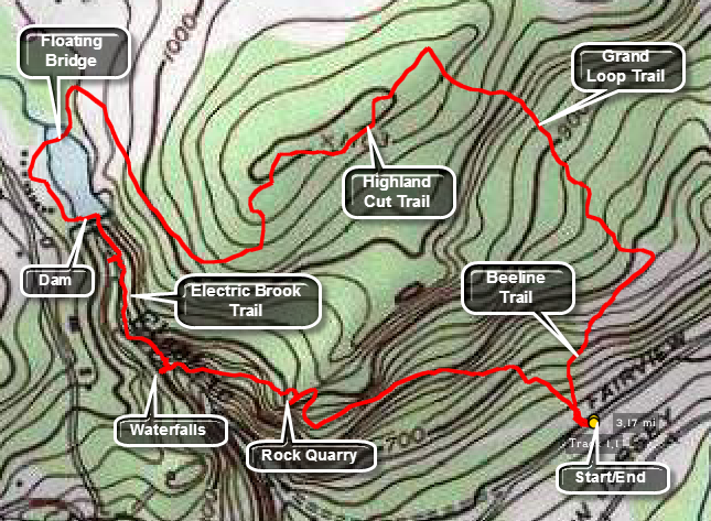
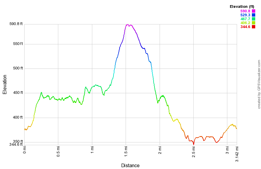
Exit Interstate 80 at exit @7A And proceed south on State Route 206 to Chester. Turn right on County Route 513. In Long Valley turn right onto Route 517 and make a QUICK left onto Fairview Avenue Watch for the Langdon Palmer Fishing Area parking lot on the right-hand side of the road. Cross the road to a trail junction where you can turn left or right. Most of the marked trail lead to the left but you will return that way. Bear right on the unblazed Beeline Trail which makes a gentle but steady ascent until it meets the yellow Grand Loop Trail at .5 miles. Several woods roads and paths cut across the trail but continue on the Grand Loop Trail. Continue straight ahead on this trail passing an exploratory iron mine pit on the right and left turn where the Grand Loop Trail splits. Continue to climb through green hardwood forest and turn left on the Highland Cut Trail at .85 miles to head. Climb slightly until at about 1.2 miles into the hike you will start to descend to the picnic area at George Lake. At the lake cross the parking area and fields to get to the bridge across the upper end of the lake. This can be confusing but you may walk to the shoreline and turn right or north until you see the bridge. The floating bridge is near the beach area and crosses George Lake. Walk south on the other side of the lake to the bridge over the dam. The Falling Water Trail parallels Electric Brook on the north side. The trail descends steeply and you will pass over a large outcrop and arrive at the main falls at 2.4 miles. The falls have an upper and lower half and are very dependent on the volume of water in the creek. The trail continues to the south and east ascending a short hill. At around 2.6 miles you will be at the top of a quarry. Many of the rocks here show signs of being "worked" with drill or hammer marks. The area is quite large. The trail descends passing the Boulder Gorge Trail and shortly meeting the Patriots Path which turns left or east and descends for .5 miles back to the parking area.
 (The image at the left shows the profile of the hike. Remember that all vertical profiles are
relative!)
(The image at the left shows the profile of the hike. Remember that all vertical profiles are
relative!)
Splitrock Reservoir: Complete Loop
| Quick Look | ||||
|---|---|---|---|---|
| Difficulty | Round trip | Total climb | Internet Maps | |
| 11.3 mi. | 1879 ft. | AllTrails | ||
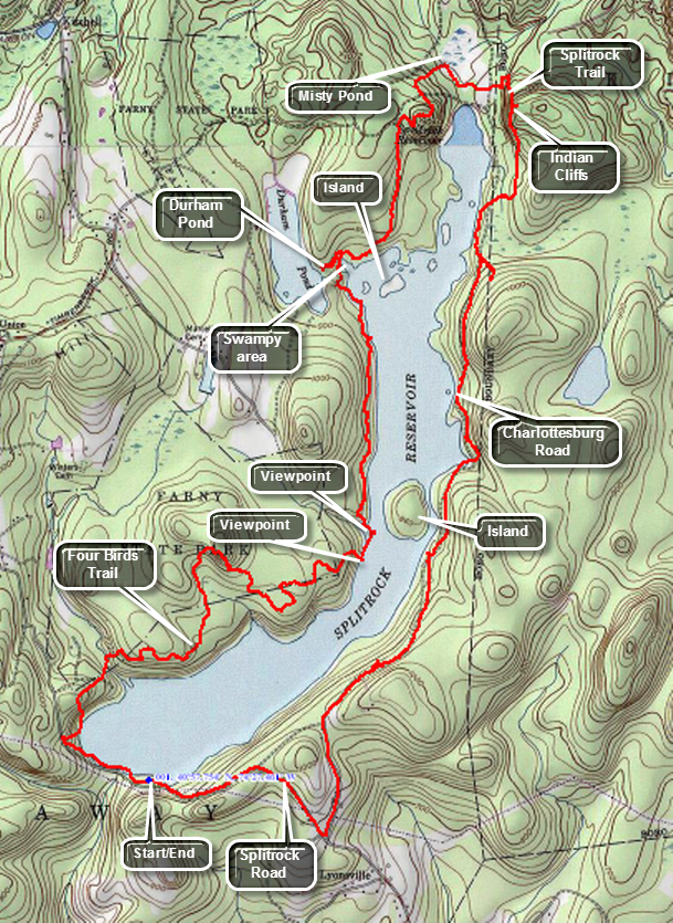
Caution: This route may be hard to follow. You may take any route from your location that ends up at the south end of the reservoir!
From I-287 North take exit 43. At the end of the ramp turn left and then right onto Fanny Rd. Follow Fanny Road to Powerville Road. Turn left on Valley Road and then right on Rockaway Valley Road. Bear left onto Split Rock and follow it to the parking area at the south end of the reservoir. If you are traveling south, there is no exit 43, so you'll want to check directions from where you are. Park only park in the designated lot as you will get ticketed if you park along the road. This parking area is the only legal boat launch area and this is a popular canoeing, kayaking and fishing area. Turn right out of the parking area onto the road and walk over the old bridge over the outlet dam. As you walk up the road, look for the beginning of the white blazed Four Birds Trail up the hill on the right. This may be hard to find so you can turn into the woods at any place and then scramble up the hill to the ridge to find the trail. In general the trail climbs up and down over some low hills with the constant changes in elevation providing a challenge. The trail markings are VERY poor especially where there are turns. The trail follows the reservoir shore for some time and then heads into the woods only to come back toward the shore. At about 1.75 miles the trail begins a more serious ascent of a small hill which does not offer any unobstructed views. At about 3 miles the trail runs parallel to the shore and if you walk down to near the waters edge, the views are spectacular. Just after this spot there is an opening in the trees and you may be able to see a fairly new house high on the opposite shore. At 4.5 miles the trail curves around an arm of the reservoir that almost looks like a beaver pond. A little further along the trail, you will walk across the outlet from Dunham Pond. In wetter seasons this area might be tricky. A little further along is an unmarked trail to the left and a wooden sign that says Winnebago. If you walk up this trail, you will be on the shores of Dunham Pond in only a few minutes. There is an impressive stonework bridge and spillway at the outlet of the pond. This may be private property so you may want avoid the area altogether. Back on the main trail, you can see a set of cliffs on the opposite side of the reservoir through the trees. These are Indian Cliffs which have one of the best lookouts on the reservoir. Somewhere around 6 miles there will be a right turn onto the blue Splitrock Trail which heads across the northern end of the reservoir. The trail passes by Misty Pond which may not be marked on all maps. At 6.7 miles into the hike you will arrive at the climb up to the cliffs. Standing on Indian Cliffs gives you a view over most of the reservoir, Misty Pond and the rest of the surrounding countryside. After this, the trail starts to descend from the cliffs and drops quite a bit of elevation. The trail heads toward the Charlottesburg Road, a wide woods road frequented by mountain bikers. At about 7.3 miles you will intersect the road. It is hard to follow the blue Splitrock Trail markings in this area. If the trail is well marked stay on the trail but it is also possible to stay on the "road" as it passes close to the reservoir.This route has some nice views of the reservoir even though you are at water level. Eventually some houses will come into view and the trail marking became clearer. They head over some rocks and up toward a ridge. It is your choice to follow the trail or the road. By staying on the road you will pas by some sandy beaches and may even find a "split rock" along the way. The woods road has a gate near the end and a parking area. At this point the road changes to gravel and is accessible by car. There doesn't seem to be any trail here so stay on the road to walk back to the parking area. There are some nice views on the way out to Splitrock Road. There is a side road that may be a shortcut but it also may be on private property. At the end of the road turn right on Splitrock Road and walk a little less than a mile back to the parking lot.
 (The image at the left shows the profile of the hike. Remember that all vertical profiles are relative!)
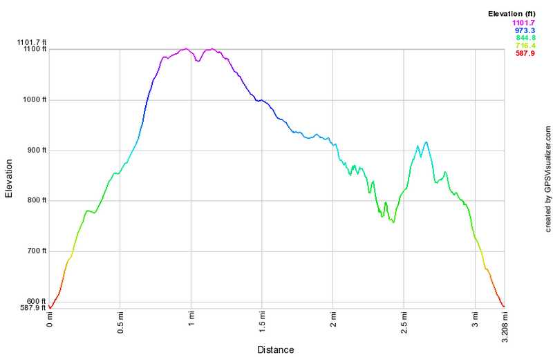
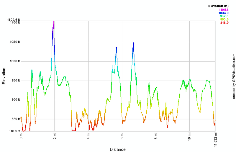
Stonetown Circular
| Quick Look | ||||
|---|---|---|---|---|
| Difficulty | Round trip | Total climb | Internet Maps | |
| 10.4 mi | 2698 ft | AllTrails | ||
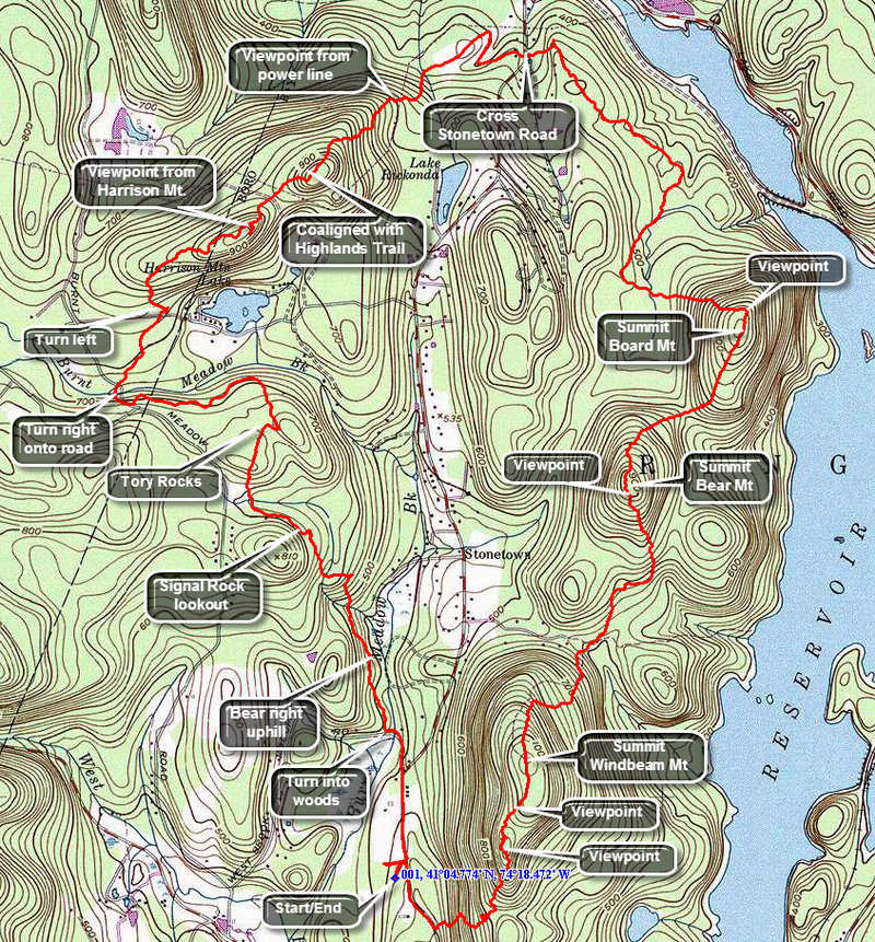
Turn south onto Stonetown Road from the Greenwood Lake Turnpike about 1.5 miles east of the historic Long Pond Ironworks. Park at the parking lot for the Stonetown Recreation Center on Mary Roth Drive off Stonetown Road near the intersection with West Brook Road. To actually get to the trail you must walk out to Stonetown Road, turn left, and hike a little over .25 miles north. At this point Magee Road bears to the left near the firehouse. Walk down Magee Road until it makes a sharp left and crosses a stream on a bridge. Watch for trail blazes which are a red triangle on a white background for the Stonetown Circular. Unfortunately, after the first blazes on the road there are no more blazes until AFTER the first fork in the trail. This problem was is repeated MANY times throughout the hike where the trail is poorly marked and blazes too far apart to help a first-time hiker. At the first fork bear left and climb to the first viewpoint at Signal Rock, about 1.5 miles into the hike. The view of Windbeam from here is good. Continue to climb up to the to top of Signal Rock and descend down the other side to head for the Tory Rocks at 2.0 miles into the hike. After the Tory Rocks the trail descends to a junction with the orange Sonoma Trail on the left. It may be difficult to find the Stonetown Circular blazes in this area. Make a ninety degree turn to the right and head down the road and across a bridge over a small stream. Pick up the red triangles and head back into the woods. You will soon be ascending Harrison Mountain where, at about 3.85 miles, a woods road runs off to the right. Walk up to an excellent viewpoint to the north and east. Back on the main trail you will cross a power line right of way and arrive at a junction with the Horse Pond Mountain Trail. At this junction the Stonetown Circular is coaligned with the Highlands Trail. From this point on the trail is well marked both by the red triangles and the aqua blazes of the Highlands Trail. From the top of Harrison Mountain there is a 500 foot descent over the next .6 miles. Along the way you will again cross the power line where there are good views down to the Monksville Reservoir. Continue on the flat part of the trail along the edge of the reservoir until you cross Stonetown Road to start back over three mountains. The next 1.25 miles are pretty flat to the base of Board Mountain. There is a nice lookout with a view down to the Monksville Dam. At 6.7 miles you begin to climb Board Mountain. The vertical gain is only 350 feet but it was over only .4 miles! The view from the top of Board Mountain was good. The descent of Board Mountain is gentle at the start but soon becomes very steep. After dropping 200 feet, there is an ascent of another 300 feet to the top of Bear Mountain. Near the summit there is a high rock with some good views. The descent into the col between Bear and Windbeam drops 400 feet over the next .7 miles into the col. From the col you start up Windbeam, the highest of the three mountains and a peak on the NJ1K list. The .6 mile climb gains 540 feet. The highest point of Windbeam has no views but there are excellent views to both the east and west a little further along the ridge. The trail dips and then ascends several times. There are good views of the reservoirs along the way. After descending into the col between Windbeam and Little Windbeam, the Highlands Trail and the Stonetown Circular separate. Stay on the red blazes of the Stonetown Circular and descend the steep trail to Stonetown Road. Once on Stonetown Road, turn right and walk up the road about .3 miles to Mary Roth Drive where your car is parked.
 (The image at the left shows the profile of the hike. Remember that all vertical profiles are relative!)
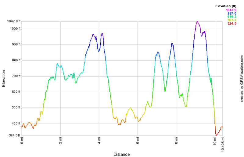
VanCampen's Glen
| Quick Look | ||||
|---|---|---|---|---|
| Difficulty | Round trip | Total climb | Internet Maps | |
| 7.02 mi | 1024 ft | AllTrails | ||
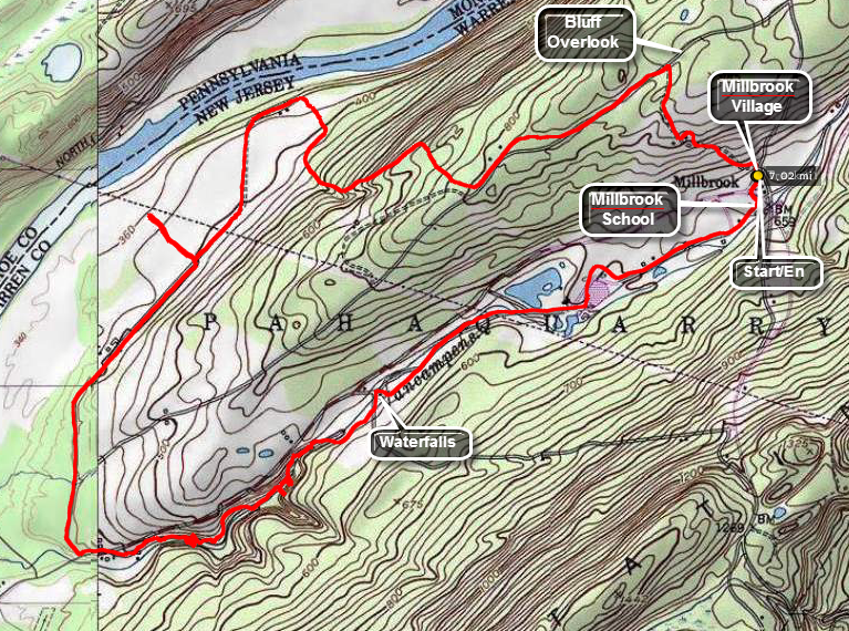
Take I84 to Milford and then Route 6 through Milford to Route 209 to the Delaware Water Gap. Cross the Dingman's Ferry bridge and get on the NPS road through the Delaware Water Gap. Head toward Millbrook Village, a collection of period buildings with some people plying the trade that was once practiced in that building. Park at Millbrook Village find the Orchard Trail that starts right across the road from the parking area. Hike up the Orchard Trail which is blazed in orange. Near the top are some open clearings but after a little more than a half mile the Orchard Trail ends. Start walking on a paved road designated the Hamilton Ridge Trail. Continue along the Hamilton Ridge Trail for another .7 miles until the orange blazed Pioneer Trail appears on the right. Head down the Pioneer Trail toward the river. After only about .2 miles, the trail turns sharply left and a road leads off to the right. Walk down to the bluffs overlooking the river for the best view on the hike. The trail continues to twist and turn and comes pretty close to the river over the next 1.25 miles. In places it may look like no one had been over the trail in some time.Cross a power line right-of-way and just after the right-of-way the trail intersects another road. Bear left on the road and after another mile on the trail/road cross Old Mine Road and walk over to the VanCampen's Glen Parking Area. Walk on the trail into the glen and stop at a waterfall less than a half mile along the stream from the parking area. Climbing a steep bank and continue the hike. The trail runs very close to the stream in some places and the rocks can be slippery. After crossing a bridge, approach another falls. A set of stairs takes the trail to the area above the falls where the trail continues. The stream has cut deeply into the rock above this waterfall. Head up the bank on the trail. The trail intersects a road but signs point out the trail. At the next road crossing there were no signs or blazes and the correct path may not be obvious. Go straight ahead and cross the same power line right-of-way as before. The trail became less distinct as the bushes close in. Some logs will help you to get through the swampy area and find a bridge over the stream. The trail then leads through the Watergate Recreation Area which has a lake and a few ponds. Walk out the access road and pick up the path back to Millbrook Village passing the old Millbrook School No. 82. More buildings will soon appear. Walk out to the road and cross it to the parking area.
 (The image at the left shows the profile of the hike. Remember that all vertical profiles are
relative!)
(The image at the left shows the profile of the hike. Remember that all vertical profiles are
relative!)
Warwick Turnpike to State Line
| Quick Look | ||||
|---|---|---|---|---|
| Difficulty | Round trip | Total climb | Internet Maps | |
| 7.2 mi | 1210 ft | AllTrails | ||
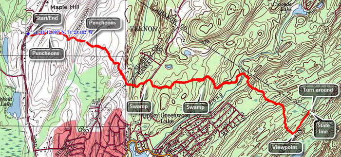
Follow Route 17A through Florida and Warwick until it turns into Route 94. We followed Route 17A through Florida and Warwick until it turned into Route 94. Turn left on Warwick Turnpike and drive about 2.7 miles. Look for a pulloff on the left after the New York-NewJjersey border. The first part of the rail passes over some puncheons and then through some hardwoods passing a field on the left. The trail surface here is packed dirt. After ascending a small hill begin to descended to a wetter area where you may notice an increase in insects. Work your way through some wet spots where small streams crossed and over some puncheons that span muddy ground. Ascend a little and then cross another trail or path. Arrive at Longhouse Drive about 1.5 miles into the hike. Here the trail turns left and follows the road several hundred feet before turning right back into the woods. Head almost due east and for the next 1.1 miles the trail rolls some and switches directions as it avoids two swamps. At 2.6 miles the trail turns southeast and begins to parallel the New York-New Jersey border as it begins to ascend to the ridge. Over the next .5 miles you will gain 285 feet and the terrain begins to look more like the Bearfort-Bellvale Ridge. The trail begins to roll some now and at 3.3 miles ascends to the top of a rock outcrop. There is a view of some water which may be the first view of anything on the hike. At this point the trail turns left to head north directly for the border. As you walk you will come across some blue blazes and an SL marked on the rock. This is the State Line Trail and the border is close at 3.6 miles. Turn around and begin the trek back to the car.
 (The image at the left shows the profile of the hike. Remember that all vertical profiles are relative!)
Wawayanda State Park North
| Quick Look | ||||
|---|---|---|---|---|
| Difficulty | Round trip | Total climb | Internet Maps | |
| 11.4 mi | 1134 ft | AllTrails | ||

Take State Route 17 to exit 124 and take Route 17A and Route 94 through Florida to Warwick. Continue through Warwick on Route 94 and turn left on the Warwick Turnpike not far outside of town. After 15 miles, arrive at the park access road. Turn right and park near the office. Find the blue Hoeferlin Trail that passes by the iron mines to the right of the office with your back to the access road and parking area. The trail is an almost flat woods road that heads north paralleling the Warwick Turnpike. At .25 miles we cross the AT and continue north. At .45 miles you will be in the vicinity of the first iron mine which is unnamed on the map. Walk off the trail to the right and look for depressions in then ground with piles of rock next to them which are the "tailing" from these explorations. There are a few bigger pits and many small ones. When the United States was first forming and well into the 19th century the only source of iron or implements made from iron was from other countries. This was expensive and, sometimes, an unreliable source. The hills of northern New Jersey and what is now Harriman State Park in New York, as well as some other locations, proved to be a good source of iron until the mid to late 19th century. Walk back out to the trail and continue north. Within a short distance, the trail intersects a gravel road where you should keep to the right to continue north to the Green and Wawayanda Mines. The Green Mine is located at about 1 mile along the trail where the Hoeferlin Trail turns sharply to the left. The mine is on the other side of a creek and swamp and can be accessed after crossing the creek on a bridge. Walk east to the ridge and begin a slight ascent to the top of the ridge. There are a few small depressions but nothing more dramatic than the previous "mine". Walk south along the ridge and until you see some fencing. The fencing surrounds a deeper pit with a collapsed adit. Some paths continue along the ridge and there are areas where the bank has been cut away. A little further south there is another fenced area. This one is much more interesting as the fence is metal and surrounds a deep shaft with stone sides. The adit is filled with water but appears to be quite deep. Head back north to the point where you turned off the road. Where the Hoeferlin Trail heads west, continued north on the old Wawayanda Road. Turned east at about 1.2 miles from the office and watch for paths or a woods road that runs to an area that has been cleared and to a bank that seems to have been mined. Continue up and over the bank still heading east. There are three or four more pits above the bank. Head a little to the north where there is a water filled pit. Turn south again and walk a little to the west watching for another area with a deep cleft in the one bank and an adit cut into the other. The adit is obviously collapsed but the amount of tailings and the work done in the area indicates that it was a significant source of ore. Return to the main trail and walk south to the junction with the Hoeferlin Trail. Turn west to follow the trail northwest to the blue Iron Mountain Trail. At 2.4 miles turn left on the Iron Mountain Trail which is another wide and well-maintained gravel road. Continue along the road crossing the AT again at 3.4 miles. At 4.6 miles cross a park road heading for the boat launch on Wawaynada Lake. Walk up a small hill and across the parking area at the boat launch to the shores of the lake. Head to the left around the end of the lake toward the dam on a pathway. At the dam follow another pathway without crossing the dam. This pathway brings you to a large stone structure on the left side of the trail that is protected behind a chain link fence. Although the wooden roof has seen better days, the rest of the structure is well preserved. This is the Wawayanda Furnace which operated from the 1840's to well passed the Civil War. It processed raw iron ore from the surrounding mines turning it into pig iron which could them be formed into implements. From the furnace, walk a little to the east to pick up the yellow Double Pond Trail. Follow the paved Double Pond Trail as it winds passed several campsites and then immediately turns back into a trail after passing a gate. The trail is rocky and heads uphill a little. At 6.25 miles you will come to the trail junction with the Cedar Swamp Trail. Turn right or south on the Cedar Swamp Trail. Head south and almost immediately you will run into the boardwalk. At times the water may be too ugh to walk to the end of the boardwalk but you can always turn around and retrace your steps. It initially passes over a wide and open swamp which has a small stream in the middle. The boardwalk actually consists of three tiers. The bottom tier is constructed of crosspieces made of a composite material. They are lighter than cement but heavier than wood and appear to be built to resist the decay brought on by being immersed in water. On top of the composite crosspieces are wooden ones and on top of that the wooden decking. Walked along the boardwalk hemmed in by laurel in most places. Enjoy the Atlantic white cedar which is different than the usual red cedar seen in most northeast forests. Eventually the boardwalk ends. Continue to follow the trail until it ends at the green Banker Trail. Turn left to head east and then north. The Banker Trail heads north along the eastern edge of the cedar swamp. It is a well constructed trail but has no real surprises or attractions. As you near the Banker Road trailhead, turn right of the red Plymouth Lane Trail which heads north to connect back to the Double Pond Trail. The trail avoids walking out to Banker Road and using it to get to another trailhead. At 9.6 mile you will hit the Double Pond Trail. Turn right to walk to the beginning of the Hoeferlin Trail. Walk toward the parking area on Double Pond Road and turn left or north just before getting there. A sign marks the beginning of the blue Hoeferlin Trail and indicates the office is 1.8 miles away although it is closer to 1.6 miles. Starting out on the trail it is very rocky as it heads due north. Near the end there are a few small hills just to make the hike memorable. You will break out onto a park road with the office and your car straight ahead.
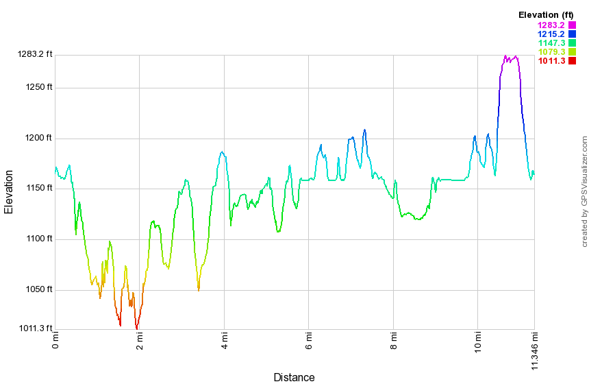 (The image at the left shows the profile of the hike. Remember that all vertical profiles are relative!)
Wawayanda Vista to Warwick Turnpike
| Quick Look | ||||
|---|---|---|---|---|
| Difficulty | Round trip | Total climb | Internet Maps | |
| 8.5 mi | 1940 ft | AllTrails | ||
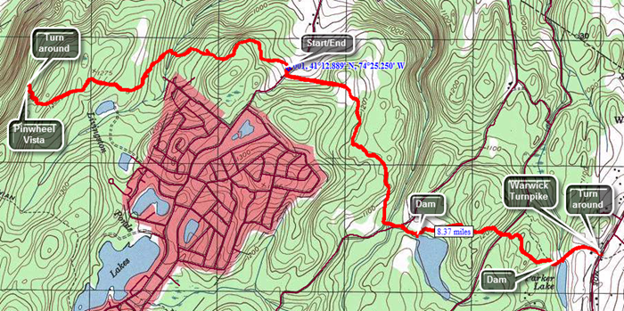
Note: This route begins on Barrett Road and proceeds to the Pinwheel Vista on Wawayanda Mountain where you turn around. You will hike back past your car and to the Warwick Turnpike where you will turn around and hike back to the car.Follow Route 17A through Florida and Warwick until it turns into Route 94. Just before the New Jersey border turn left on Barrett Road. Barrett Road climbs to the top of a ridge. At about 1.4 miles there is a pulloff on the right but there are no sings for the AT. This is the place to park! Begin by ascending a small hill through some hardwoods and then descending the other side. You may hear voices on your left as there is a development of residential housing in that direction. At .8 miles descend to a small creek and cross a small wooden bridge to get to the other side of the stream. The bridge simply lies on the rocks and is tethered by a cable to a steel rod to restrain it during high water! Continue your hike with a fairly steady but easy ascent toward the Pinwheel Vista. At 1.4 miles there is a slight dip and by 1.7 you will hit a high point. There is a "mailbox" that acts as a sign-in for the AT. There is an sign that points left indicating an old lookout about .8 miles away. It may have been a lookout at some point but there is now no view. Continue on a descent to the area just before the "Stairway to Heaven", the staircase that leads down to Route 94. A large stone cairn and blue blazes indicate the side trail to the right to the Pinwheel Vista. Allow some time to take in the beautiful views and snap some pictures before heading back toward the car. As you approach Barrett Road and your car stay on the trail and cross the road. Continued on the AT as it begins an ascent on an old road. At the top of the hill turn off the road to stay on the AT and start to descend a little. The trail begins to roll a little and finally descended to cross Iron Mountain Road and then a small stream. Along the is a beaver lake or pond. At some point you will have entered Wawayanda Park and the trail will be blazed with blue markers as well as the white AT blazes. Ascend a small hill and then descend the other side to cross a park road. The trail starts to ascend and then rolls some. At 5.8 miles pass another beaver pond and then cross another bridge. By now you should hear the traffic and at 6 miles you will be at the Warwick Turnpike. Turn around and follow the trail back to your car.
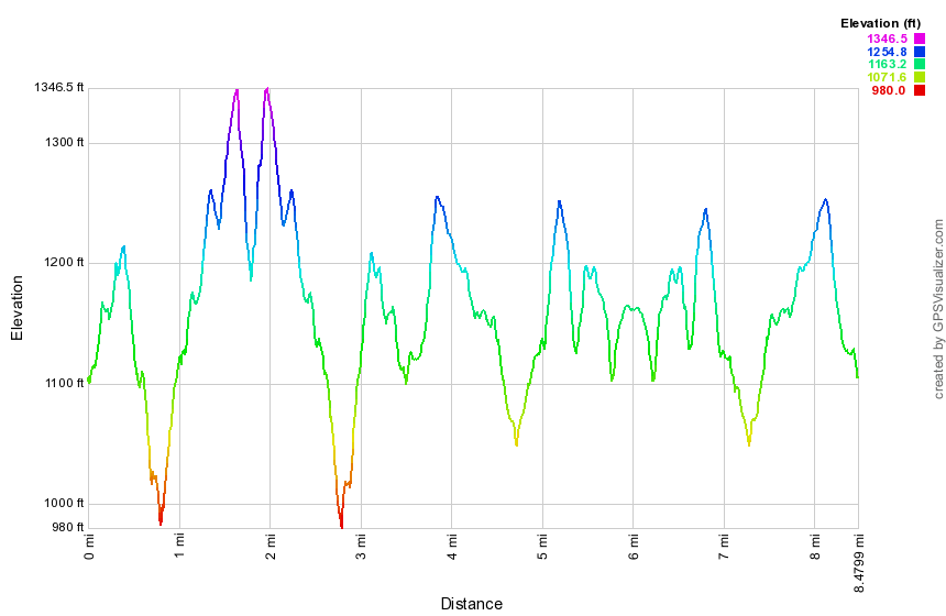 (The image at the left shows the profile of the hike. Remember that all vertical profiles are relative!)