
Shawangunk Trails
Besides the thirty-five 3500 foot peaks in the Catskills, there are many other smaller mountains to climb. In addition, there are hundreds of miles of trails to hike. There are also MANY other places to hike also. I have divided the Trails section into list of All Trail, the Catskills, the Shawangunks, Bear Mt/Harriman, East Hudson, West Hudson, New Jersey and Other Trails. The All Trails list includes over 400 different trails and may load slowly on your computer. The "divided" list should load more quickly.
You can view all the Shawangunk Trails here.
Clicking on ![]() will bring up an index of trails. Clicking on
will bring up an index of trails. Clicking on ![]() will return you to the top of the page.
will return you to the top of the page.
Basha Kill towards Wurtsboro
| Quick Look | ||||
|---|---|---|---|---|
| Difficulty | Round trip | Total climb | Internet Maps | |
| 4.7 mi. | 96 ft. | AllTrails | ||
 The Basha Kill is a 2400 acre wetland and wildlife preserve in the southern part of Sullivan County. Among other things it is home to at least 50 species of birds and especially bald eagles. The remains of the Port Jervis to Kingston branch of the O&W forms a rail trail on the southeastern shore. On the northwestern shore is the D&H Canal and the towpath. The two can be combined for a loop using Haven Road to cross the marsh on the northern end and Otisville Road to swing around the southern end. This loop is over 10 miles and would be difficult for beginning hikers!
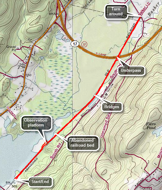
Take Route 17/I 86 to exit 113 and head south on Route 209 toward Port Jervis. After 1.7 miles turn left on Haven Road. Follow the road as it crosses the Basha Kill. At the first intersection turn left and park in the large lot. Head northeast on the old railroad bed which makes up a good part of the SRT in this area. There are no blazes for either the SRT or Long Path but the route is clear as it simply follows the railbed. Within a short distance there is a nice viewpoint over the Basha Kill to the ridges beyond. At about .5 miles there is a path to the left leads to an observation tower with good views to the north and west. You may choose to visit the tower on the way out or on the way back. You may encounter a few wet areas on the trail and some mud. There are also several places where old wooden bridges cross the water. These bridges are slowly deteriorating and the whole atmosphere is one of neglect. At 1.8 miles there is an underpass beneath the highway allows hikers and wildlife to pass without a problem! At 2.3 miles the trail ends at Pennsylvania Avenue just outside of Wurtsboro. Turn around and retrace your steps to the car.
(The profile of the hike is not posted as the walk is almost completely flat and the profile makes it look much more daunting!)
Basha Kill Tower
| Quick Look | ||||
|---|---|---|---|---|
| Difficulty | Round trip | Total climb | Internet Maps | |
| 2.3 mi. | 94 ft. | AllTrails | ||
 The Basha Kill is a 2400 acre wetland and wildlife preserve in the southern part of Sullivan County. Among other things it is home to at least 50 species of birds and especially bald eagles. The remains of the Port Jervis to Kingston branch of the O&W forms a rail trail on the southeastern shore. On the northwestern shore is the D&H Canal and the towpath. The two can be combined for a loop using Haven Road to cross the marsh on the northern end and Otisville Road to swing around the southern end. This loop is over 10 miles and would be difficult for beginning hikers!
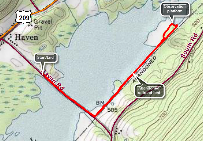
Take Route 17/I 86 to exit 113 and head south on Route 209. After about 1.7 miles Haven Road appears on the left. Turn left here and drive to the parking area on the left to park. Start your hike by walking southeast on Haven Road through the marsh toward the rail trail on the eastern shore. Turned left or northeast on the rail trail. The trail here is relatively firm even when it has been raining. After about a mile watch for a trail to an observation tower and turn left on this unmarked trail. Within .1 miles you will be at the tower which is more of an observation platform. There are nice views over the marsh to the north and west. Return to the main trail and turn right to retrace your steps to the car.
(The profile of the hike is not posted as the walk is almost completely flat and the profile makes it look much more daunting!)
Hanging Rock Falls
| Quick Look | ||||
|---|---|---|---|---|
| Difficulty | Round trip | Total climb | Internet Maps | |
| .5 mi. | 250 ft. | AllTrails | ||
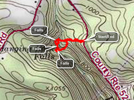
The Falls is located on Ulster Heights Road in Greenfield Park just west of Evansville. There IA a small parking area on the west side of Ulster Heights Road about .4 Niles south of the intersection with Marcus Road. Park in the pulloff and then follow a path down hill to a woods road. Turn to the right and follow the woods road and a path out to the Beer Kill. The path passes over some exposed bedrock. The stream is called the Beer Kill because the water is slightly yellow and foams as it runs over the rocks. Walk out to the edge of the stream to see a falls. BE CAREFUL as you walk on the rocks as they can be slippery and it is a long way down! Look downstream to see other falls that are even more impressive. Follow some of the informal paths downstream to see at lest two more falls. Eventually you will come to an almost vertical descent where it may be a good idea to stop. When you have finished exploring, head back the way you cam or explore a little.
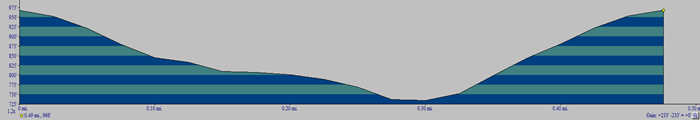 (The image at the left shows the profile of the hike. Remember that all vertical profiles are relative!)
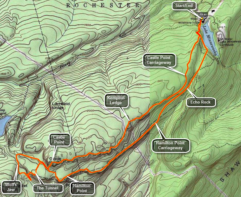
Minnewaska: Castle Point - Hamilton Point
| Quick Look | ||||
|---|---|---|---|---|
| Difficulty | Round trip | Total climb | Internet Maps | |
| 8.6 mi | 1083 ft | AllTrails | ||
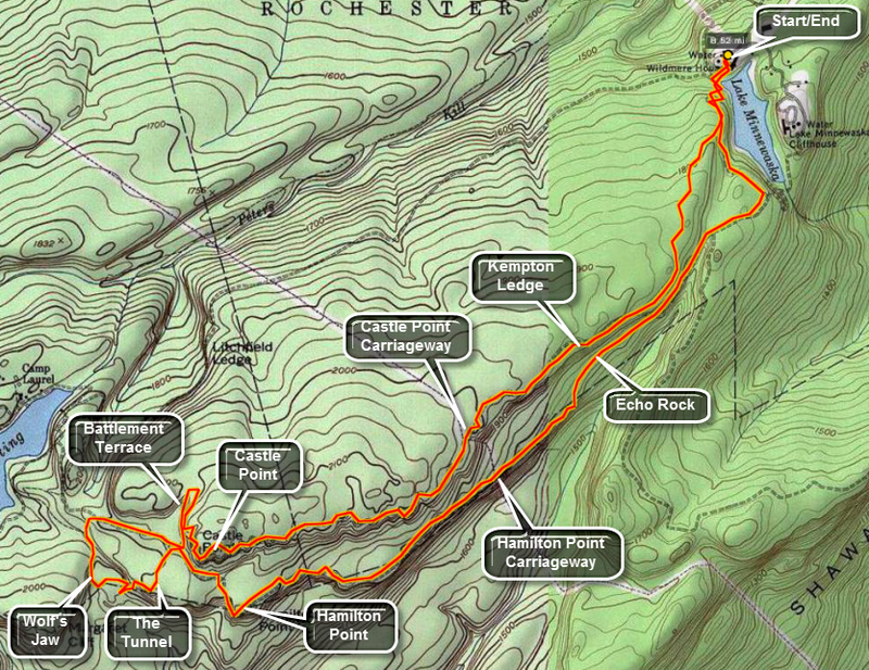
Park at the parking lot in Minnewaska State Park on NY 55 just outside of Gardiner and New Paltz. The cost is $6. Walk toward the lake and follow the red blazed Minnewaska Carriageway. Ignore the first junction with the Upper Awosting Carriageway and continue to the blue blazed Castle Point Carriageway. Turn right here where a sign marks the way. The carriageways are not in good shape for carriages but allow hikers to make excellent time. Watch for the views along the way. Looking to your left you will shortly see Patterson's Pellet. In a little while the ledges and cliffs that make up the Gertrude's Nose Trail and Gertrude's Nose itself come into view. Stay on this until carriageway as it slowly ascends to Castle Point. The views along the way are nice but those from the Point are superb. As you continue on the aqua blazes of the Long Path can be found along with the blue blazes you have been following. The trails run concurrently for some time as they snake through Battlement Terrace. From the Terrace the view of Lake Awosting is magnificent. The lake is very blue and about 1.5 miles long. The trail passes beneath the imposing rocks of the Terrace and meets the yellow blazed Hamilton Point Carriageway. The aqua blazes continue almost straight ahead as the Long Path breaks off here. At this point the carriageway turns left to Hamilton Point or right toward Lake Awosting. You can make several choices here depending on your conditioning and the time you have. Turn right on the carriageway and descend gradually until an unmarked trail turns off to the left. The trail is obvious but there are no signs or blazes. This trial leads to the Wolf's Jaw were impressive slabs of rock hang over the trail. This short spur trail meets the Long Path again as it descends from the Hamilton Point Carriageway. Turn left on this trail and cross a small creek. You will start to ascend back toward the Carriageway. You reward for taking this route is The Tunnel. This is an area where the rocks have cracked and others have fallen on top of them forming a sort of "tunnel". The passage is narrow particularly with a full pack! After The Tunnel is a low rock overhang. The trail then ascends back to the yellow blazed Hamilton Point Carriageway where you should turn right. The trail descends some and them climbs to Hamilton Point which gives more spectacular views of the ravines below and the ridges on the others side. Continuing along there are more views especially at Echo Rock. Shortly after this the carriageway meets The Millbrook Mountain Carriageway. Continue on the yellow blazes until they meet the red blazed Minnewaska Lake Carriageway. Turn left an continue on around the lake back to the parking area.
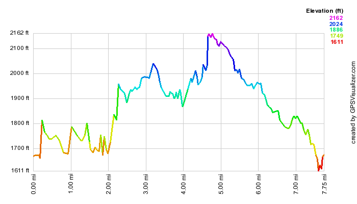
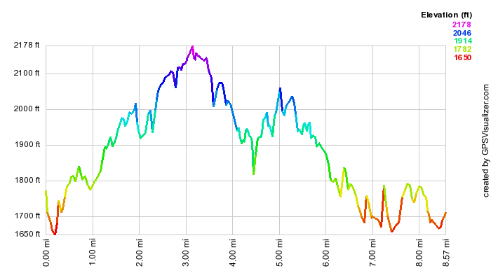 (The image at the left shows the profile of the hike. Remember that all vertical profiles are relative!)
Minnewaska: Dickie Barre to Old Minnewaska Trail
| Quick Look | ||||
|---|---|---|---|---|
| Difficulty | Round trip | Total climb | Internet Maps | |
| 7.2 mi | 1460 ft | AllTrails | ||
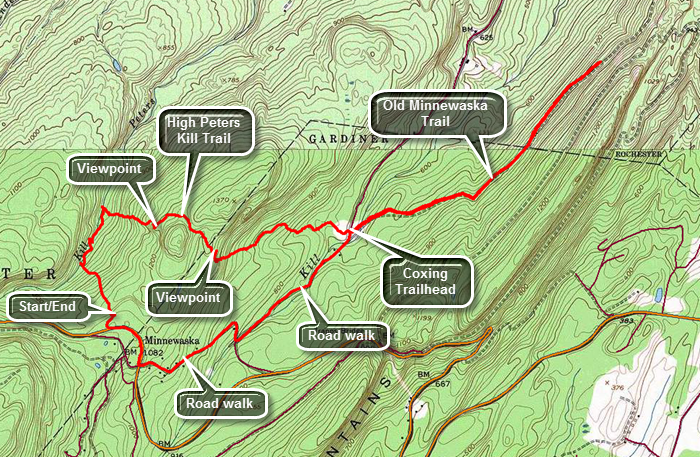
Park at the parking lot for the main office of Minnewaska State Park on NY 55 1.1 miles east of the main entrance. This is sometimes referred to as the Peters Kill parking area. The cost to park is $8 and the hours are 9 a.m. to 5 p.m. Head out on the Red Loop Trail from the western end of the parking area. The trail is flat for the first few hundred feet and then begins to drop towards the Peters Kill and parallels. At about .3 miles there is a path down to the stream which you may use to investigate the Peters Kill. There are several others along the way and it is your choice whether or not to use them. Turn right when you get to the yellow connector trail and follow it down to the blue High Peters Kill Trail. The SRT is co-aligned with this trail at this point. When the yellow trail ends at the High Peters Kill Trail, you should turn right but you may want to turn left and walk down to the stream to investigate the bridge there. Head east on the blue trail as it continues along the Peters Kill. Over the first .75 miles of the hike there will be a loss of over 350 feet in elevation. The trail then begins to climb toward Dickie Barre, one of the premier rock climbing areas. For the next .25 miles the trail gains about 370 feet and averages over a 21% grade. There are some steep dropoffs on the right and a hint of a nice view but it is hard to get a clear view through the trees. At just over 1 mile there are some ledges to the right of the trail which have some excellent views to the south, east and west. To the west and east are some of the cliffs that draw rock climbers to the area. Behind the cliffs on the right or to the west rise some mountains. Head back to the main trail and follow it around to the north side of the hill without actually hitting the top. At 1.3 miles the trail hits its maximum elevation of 1270 feet as it passes between higher areas to both the left and right. At this point it begins to descend toward the Coxing Trailhead in the Mohonk Preserve. The descent heads south to about 1.6 miles where the trail turns northeast and east. There are stone steps that form part of the descent. It isn't far to the trailhead which is about 2.4 miles into the hike and some 590 feet below the highest point. Cross the road to get on the Old Minnewaska Trail. This is in the Mohonk Preserve which charges $12 per day for hikers. This is a "use fee" nit a parking fee and all hikers are required to pay or become members. The Visitors Center is on Route 44/55 on the way to New Paltz and Gardiner. The trail is relatively flat compared to the High Peters Kill Trail. Within a couple hundred feet where there is a bridge over the Coxing Kill. There are signs in the area explaining the contributions of the Smiley family and one denoting the foundation of the Enderly house. Continue east northeast on the trail until about 4 miles. On the left or to the north there are some mountains but the view is limited until just before the turnaround point. Of course, you can choose to turn around at the Coxing Trailhead or walk even farther along the Old Minnewaska Trail. Back at the trailhead turn left on Clove Road at about 5.5 miles. Walk on Clove Road with the Coxing Kill on the right side of the road. Continue up Clove Road to the intersection with Trapps Road and turn right. At Route 44/55 turn right and walk about .3 miles on the main road back to the parking area. The road walk is shorter and easier than the trail. You can choose to make the hike a true "out-and-back" by simply reversing your route out.
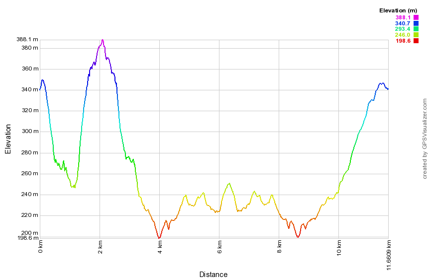 (The image shows the profile of the hike. Remember that all vertical profiles are
relative!)
(The image shows the profile of the hike. Remember that all vertical profiles are
relative!)
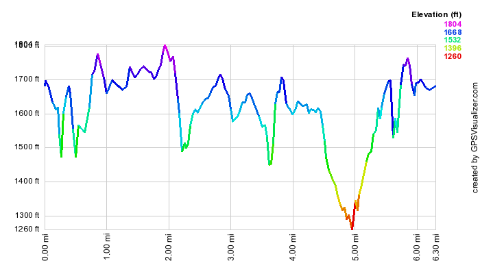
Minnewaska: Gertrude's Nose and Millbrook Mountain
| Quick Look | ||||
|---|---|---|---|---|
| Difficulty | Round trip | Total climb | Internet Maps | |
| 6.5 mi | 1177 ft | AllTrails | ||
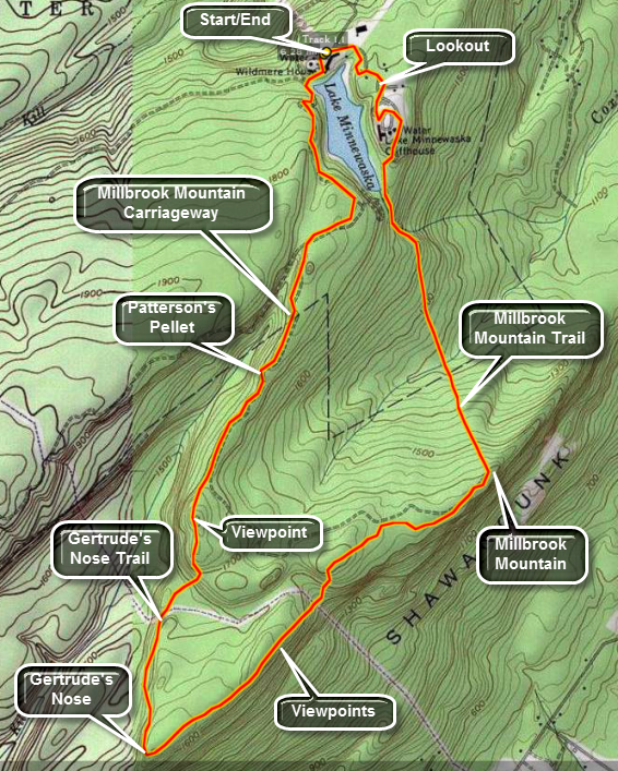
Park at the parking lot in Minnewaska State Park on NY 55 just outside of Gardiner and New Paltz. The cost is $6. Walk toward the lake and follow the red blazed Minnewaska Carriageway. Ignore the first junction with the blue blazed Castle Point Carriageway and continue to the junction with the yellow blazed Millbrook Mountain Carriageway. Along the way watch for Patterson's Pellet, a large glacial erratic which is rather famous. It has its own sign! Stay on this until the red blazed Gertrude's Nose trail leaves to the right. Be prepared for a more difficult hike as this is a trail and it starts to rise and fall almost immediately. Within less than a mile you will be at Gertrude's Nose. Continue on the red trail as it follows the cliff face and warps around onto Millbrook Ridge. In slightly more than a mile you will be on the highest point of the ridge, Millbrook Mountain. At this point you can follow the yellow blazed Millbrook Mountain Carriageway back. Watch for the red blazed Millbrook Mountain Trail as it turns left or north. This trail is often wet especially when it has rained. You may feel like you are hiking down a stream bed until you cross Coxing Kill and start to ascend again. The ascent is rather long and steep at times. The last part of the trail parallels the outlet of Lake Minnewaska. At the end of the trail turn right on the red blazed Minnewaska Carriageway. Follow this "road" as it winds its way around the lake and back to the parking area. There are several nice viewing areas overlooking the lake including a gazebo set high on a rock ledge. There is also a small wooden arch bridge that passes over another part of the carriageway.
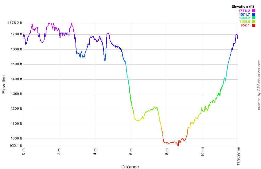
 Minnewaska: Gertrude's Nose Long Loop
| Quick Look | ||||
|---|---|---|---|---|
| Difficulty | Round trip | Total climb | Internet Maps | |
| 12.0 mi | 1996 ft | AllTrails | ||
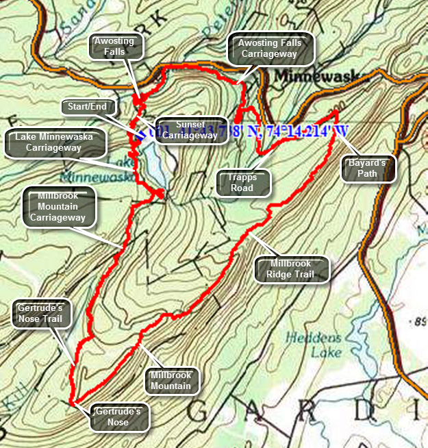
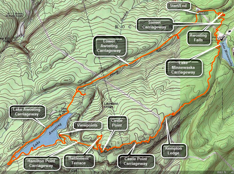
Park at the parking lot in Minnewaska State Park on NY 55 just outside of Gardiner and New Paltz. The cost is $6. Walk toward the lake and follow the red blazed Lake Minnewaska Carriageway. Ignore the first junction with the blue blazed Castle Point Carriageway and continue to the junction with the yellow blazed Millbrook Mountain Carriageway. Along the way watch for Patterson's Pellet, a large glacial erratic which is rather famous. It has its own sign! Stay on this until the red blazed Gertrude's Nose trail leaves to the right. Be prepared for a more difficult hike as this is a trail and it starts to rise and fall almost immediately. Within less than a mile you will be at Gertrude's Nose. Continue on the red trail as it follows the cliff face and wraps around onto Millbrook Ridge. You will descend into a ravine and cross a power line right-of-way. Just after this watch for a deep hole off the trail to the right. In warmer weather the air from this hole will be MUCH cooler than the surrounding air. In slightly more than a mile you will be on the highest point of the ridge, Millbrook Mountain. At this point follow the blue blazed Millbrook Ridge Trail as it follows the ridge heading toward the Trapps. The trail can be interesting at times as it covers some slippery and slanted rock faces. Watch for views down across valley on the right and over to the Catskills on the left. Eventually the trail begins to descend and at about 7.5 miles Bayard's Path cuts off to the left. It descends from the ridge and meets Trapps Road. Turn left on Trapps Road and enjoy the walk on this wide and flat surface. At about 8.5 miles you will cross the Coxing Kill and the road will then start a continuous uphill climb. It will go through a hairpin turn and then cross Lyons Road at about 9.5 miles. Just beyond the crossing Trapps Road ends and becomes Awosting Falls Carriageway. At 10.3 miles you will get very close to Route 44/55 at an access point from that road where the Peters Kill crosses under the road. From here it is only about a .5 mile walk along the Peters Kill to Awosting Falls. Walk passed the falls and up the path until you are almost at the park road. Turn left on the Sunset Carriageway which climbs back to the parking area over the next .8 miles and 350 feet of vertical gain.
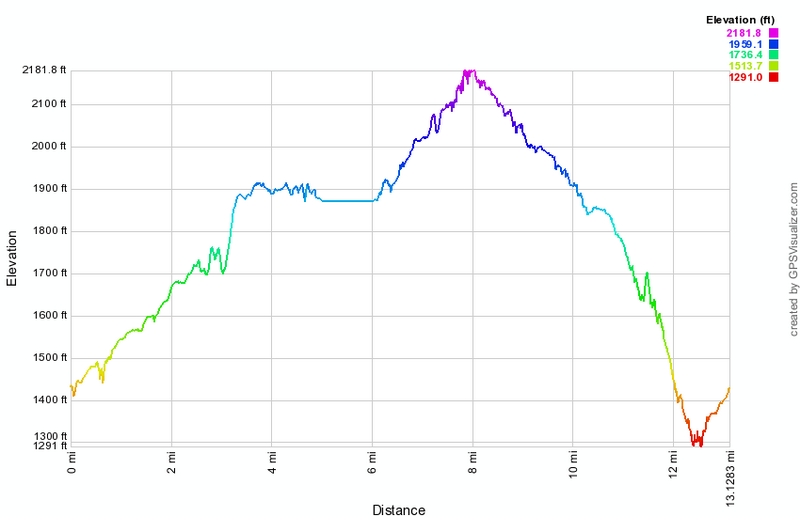
 (The image below shows the profile of the hike. Remember that all vertical profiles are relative!)
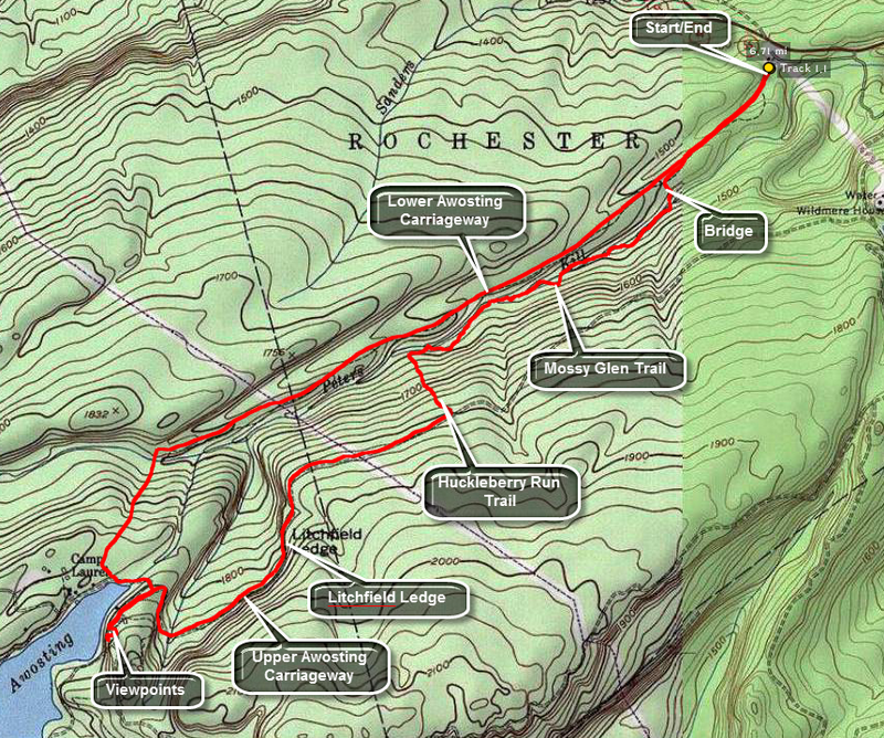
Minnewaska: Jenny Lane Loop
| Quick Look | ||||
|---|---|---|---|---|
| Difficulty | Round trip | Total climb | Internet Maps | |
| 10.0 mi | 1735 ft | AllTrails | ||
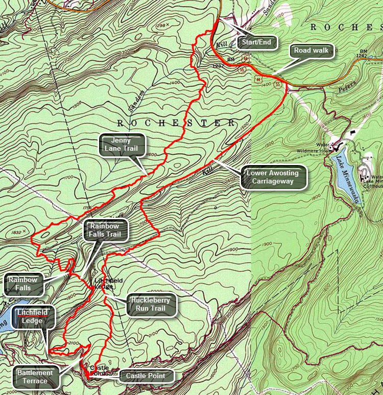
Park at the Jenny Lane parking area near Minnewaska State Park just north of the main entrance on Route 44/55. Walk out to the road and turn left or south. Walk a few hundred feet along the road watching for the SRT blazes on the other side. They can be hard to spot the first time you visit the area. There are rattlesnakes in this area and throughout the park. Be careful to avoid them as they usually give a loud warning. The walk along the Jenny Lane Trail is generally pleasant even though there are no major viewpoints. The trail is generally well-maintained but brush can encroach in some areas. Near the highest point on the trail is a limited viewpoint to the Peters Kill below. It is in this area that the trail begins to travel over more exposed rock which can be very slippery when wet or icy. At 2.8 miles turn right on the Lower Awosting Carriageway and walk over the causeway over the Peters Kill. Just after the bridge, the trail turns left into the woods and quickly begins ascending again. The rock faces here can be slippery and the trail meets a stream which can be hard to cross when the water is high. After the stream, continue to climb over open rock. Look over your shoulder for an excellent view of the Catskills. Follow the trail as it winds its way down the other side of the ridge toward Rainbow Falls. Along the way there is another viewpoint across to the next ridge. The descent down to Rainbow Falls is steep requiring some rock scrambling. It is only a short walk to Rainbow Falls which has a very seasonal flow. During dry weather there may be no falls at all. In the winter icicles hang from the cliffs and ice piles up in layers at the bottom of the falls. The trail passes directly below the falls and may be very slippery in winter but the area is easy to bypass. After the falls, the trail crosses a small stream and then meets the Upper Awosting Carriageway. Continue on the Rainbow Falls Trail by crossing the carriageway and following the orange blazes. Shortly after starting up the trail there is another nice viewpoint of the cliffs with the Catskills behind them. Continue to gain elevation until at 4.7 mile you arrive at Litchfield Ledge which has some more nice views. A little further along is another nice view of the cliffs that make up the Battlement Terrace and Castle Point. Continue along the trail until it ends at the Castle Point Carriageway where it turns left and heads up the hill toward Castle Point. The carriageway is easy to walk on and is sited along the edge of the cliffs giving ever better views from the Battlement Terrace to Castle Point. Soon the Huckleberry Run Trail starts on the left. You can turn here or walk the few hundred feet up to Castle Point. for views of Hamilton Point, Gertrude's Nose and the valley below. At this point the hiked has covered 5.6 miles. Once on the Huckleberry Run Trail there a few short ascents before it heads down to the Upper Awosting Carriageway. The trail is generally well marked but doesn't have any viewpoints over the 1.6 miles. After crossing the carriageway, the trail begins to lose elevation quickly. Just before the Peters Kill, the yellow blazes of the Mossy Glen Trail appear on the right. You may take this trail as it hugs the bank of the Peters Kill until very near the Lower Awosting parking area. Continued straight ahead on the Huckleberry Run Trail over open rock down to the stream. The bridge is a little downstream and is a single large log which has been squared off and has hand rails. Cross the bridge and head up to the Lower Awosting Carriageway. The Huckleberry Run Trail continues straight ahead to the Jenny Lane Trail. Turn right at the 7.5 mile mark and head toward the Lower Awosting parking area about 1.5 miles away. Once at the parking area walk out to the road and turn left to walk the shoulder back to Jenny Lane.
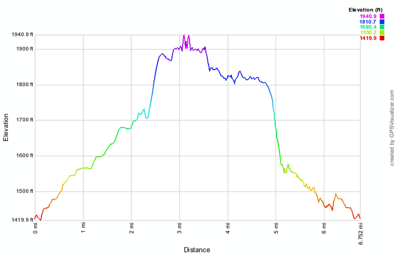
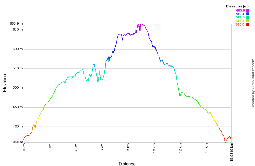 (The image shows the profile of the hike. Remember that all vertical profiles are relative!)
Minnewaska: Lake Awosting and Mossy Glen
| Quick Look | ||||
|---|---|---|---|---|
| Difficulty | Round trip | Total climb | Internet Maps | |
| 9.8 mi | 1263 ft | AllTrails | ||
 Park at the Lake Minnewaska lower parking area on Routes 44/55. Walk to the end of the parking area to pick up the Lower Awosting Carriageway. This extends 2.75 miles to the shores of Lake Awosting where it meets the Lake Awosting Carriageway. Turn left and continue on the carriageway passing the junction with the green Upper Awosting Carriageway on the left. This allows you to visit the best viewpoints over Lake Awosting to the west and north. The views extend all the way to the Catskills. The lake extends about 1.1 miles to the west. The high acidity prevents most flora and fauna from inhabiting the lake. As you walk
around the lake a ranger's cabin appears on the right side of the path. The carriageway rises as you continue. This
allows good views of the rocky "beach" on the opposite shore. Return to the junction and take the Upper Awosting Carriageway east for about 1.4 miles watching for the Blueberry Run Trail where it crosses the Carriageway. Turn left, walk a short distance and then turn right on the Mossy Glen Trail. This trail runs along the Peters Kill and will take you back to the Lower Awosting Carriageway in about 1.2 miles. Walk back to the car.
Park at the Lake Minnewaska lower parking area on Routes 44/55. Walk to the end of the parking area to pick up the Lower Awosting Carriageway. This extends 2.75 miles to the shores of Lake Awosting where it meets the Lake Awosting Carriageway. Turn left and continue on the carriageway passing the junction with the green Upper Awosting Carriageway on the left. This allows you to visit the best viewpoints over Lake Awosting to the west and north. The views extend all the way to the Catskills. The lake extends about 1.1 miles to the west. The high acidity prevents most flora and fauna from inhabiting the lake. As you walk
around the lake a ranger's cabin appears on the right side of the path. The carriageway rises as you continue. This
allows good views of the rocky "beach" on the opposite shore. Return to the junction and take the Upper Awosting Carriageway east for about 1.4 miles watching for the Blueberry Run Trail where it crosses the Carriageway. Turn left, walk a short distance and then turn right on the Mossy Glen Trail. This trail runs along the Peters Kill and will take you back to the Lower Awosting Carriageway in about 1.2 miles. Walk back to the car.
 (The image at the left shows the profile of the hike. Remember that all vertical profiles are relative!)
Minnewaska: Lake Awosting to Lake Minnewaska
| Quick Look | ||||
|---|---|---|---|---|
| Difficulty | Round trip | Total climb | Internet Maps | |
| 12.5 mi | 1550 ft | AllTrails | ||
 Drive into the main gate at Minnewaska State Park. After paying the fee turn right and park in the lot at the end of the road. Walk out of the southwest end of the lot on the Lower Awosting Carriageway. The walk along the carriageway is pleasant even though the path climbs for about 2.3 miles where it crosses the Peters Kill. Continue on the carriageway to 2.9 miles where there is a junction with the Lake Awosting Carriageway. Turn right and start around the lake in an anticlockwise direction. As you walk around the lake there will be some viewpoints to take pictures of the lake and the cliffs beyond. Continue around the southeast end of the lake and start back toward the northeast. The trail around the lake is relatively flat and passes across the "beach". The trail begins to rise to some viewpoints around 5.6 miles. At 5.9 miles turn right on the yellow Hamilton Point Carriageway. At 6.5 miles turn left on the blue Castle Point Carriageway. You will pass below Castle Point on a switch back and then walk through the Battlements before getting to Castle Point. Take some time to enjoy the expansive views from Castle point before continuing along the carriageway and, ultimately, back to the car. Along the way there will be numerous viewing points, some named and some unnamed. At 8.8 miles you can stop at Kempton''s Ledge. Echo Rock is below an to your right on the Hamilton Point Carriageway. Across Palmaghatt Ravine is another large boulder called Patterson's Pellet. Continue along the carriageway until at 10.5 miles you meet the red Lake Minnewaska Carriageway. Before coming down the hill to the lake notice a nice view of the Catskills through an open field. Turn right at the junction and walk around the lake stopping at the beach if you would like. The view of the lake from the beach is nice and the cliff house across the lake makes a nice picture. Walk up the hill and take a left on the orange Sunset Carriageway. Walk down the hill until you meet the red trail and turn right to walk down to Awosting Falls on the Peters Kill at 11.8 miles. Take some pictures and enjoy the view before retracing your path back up the hill. Walk straight on the red trail to the park roads and turn right to go to the entrance. Turn left and walk down the road to the parking lot and your car.
 (The image at the left shows the profile of the hike. Remember that all vertical profiles are relative!)
Minnewaska: Lake Minnewaska to Lake Awosting
| Quick Look | ||||
|---|---|---|---|---|
| Difficulty | Round trip | Total climb | Internet Maps | |
| 9.9 mi | 1150 ft | AllTrails | ||
 Park at the Lake Minnewaska upper parking area on Routes 44/55. Walk to the upper end of the lake and turn right
toward the western shore of the lake. After walking down the hill, turn right onto the green blazed Upper Awosting
Carriageway. There are many other possible carriageways and trails to use to get to the lake. After about 3.5 miles,
the black blazes of the Lake Awosting Carriageway will become evident. Along the way several interesting landmarks
can be seen and several trail options exist. At about 3.0 miles there is a lookout that gives a view of Rainbow Falls.
The "falls" is simply a cataract off a cliff and the volume of water determines how impressive it is. In the same area
the Long Path heads off to the right down to the base of the falls and on to the Lower Awosting Carriageway. Turning
left on the long path as it crosses the Upper Awosting carriageway will take you up onto Litchfield Ledge but this
makes getting to the lake more difficult. On the carriageway you will pass under the Ledge and can see the impressive
rock cliffs rise above you.
Park at the Lake Minnewaska upper parking area on Routes 44/55. Walk to the upper end of the lake and turn right
toward the western shore of the lake. After walking down the hill, turn right onto the green blazed Upper Awosting
Carriageway. There are many other possible carriageways and trails to use to get to the lake. After about 3.5 miles,
the black blazes of the Lake Awosting Carriageway will become evident. Along the way several interesting landmarks
can be seen and several trail options exist. At about 3.0 miles there is a lookout that gives a view of Rainbow Falls.
The "falls" is simply a cataract off a cliff and the volume of water determines how impressive it is. In the same area
the Long Path heads off to the right down to the base of the falls and on to the Lower Awosting Carriageway. Turning
left on the long path as it crosses the Upper Awosting carriageway will take you up onto Litchfield Ledge but this
makes getting to the lake more difficult. On the carriageway you will pass under the Ledge and can see the impressive
rock cliffs rise above you.
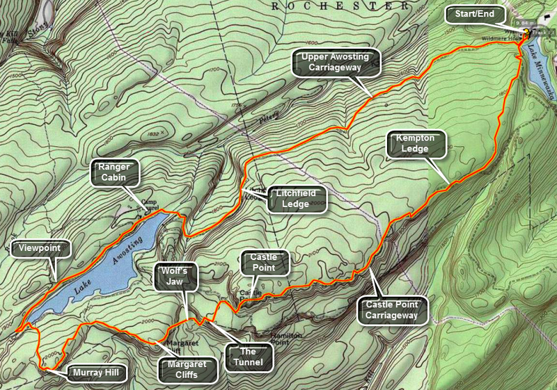
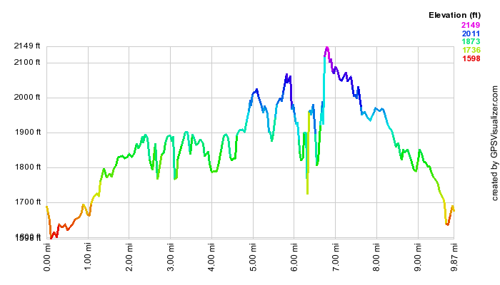
When the black blazes appear, turn right (north) and Lake Awosting will appear very shortly. The lake extends about 1.1 miles to the west. The high acidity prevents most flora and fauna from inhabiting the lake. As you walk around the lake a ranger's cabin appears on the right side of the path. The carriageway rises as you continue. This allows good views of the rocky "beach" on the opposite shore. As you round the western end of the lake keep a sharp eye out for the aqua blazes of the Long path on the right. There is no sign and the first few blazes are very faint! Turn left and the top of the path and then right at the next "junction". You will be headed for Murray Hill which appears in about .5 miles. From here views to the west reveal the Sam's Point Preserve. To the west are Margaret Cliff, Castle Point and Hamilton Point. Continue on the Long Path for about 1.5 miles and pass by Margaret Cliff which has similar views to Murray Hill. Be prepared for a steep descent into the ravine below over a rocky trail. From the bottom the Long Path again begins to ascend toward the Hamilton Point Carriageway. The total distance is about a mile but along the way there are several interesting formations. Just before crossing the stream at the bottom of the ravine, an unmarked trail goes to the left. A short distance up this trail is the Wolf's Jaw where a rock formation hangs over the trail. Continuing on the Long Path brings you to The Tunnel. Here cracks in the rocks have been given a rock "roof" forming a short but narrow tunnel. After The Tunnel, the Long Path continues its ascent (steep at times) up to the Hamilton Point Carriageway.
This carriageway leads back to the parking area. The distance is about 4 miles and it offers some good views and several attractions such as Echo Rock. After several hundred feet on the carriageway, the Long Path turns left, enters the woods and approaches the base of the cliff that is Castle Point. The Long Path works its way up to this upper level through a series of ledge and foot and hand holds. Some are more challenging than others! From castle Point the views of Lake Awosting, Sam's Point, Gertrude's Nose and the other surrounding features is truly impressive. After taking in the view, continue on the blue-blazed carriageway back to Lake Minnewaska and the parking area. This is a distance of about 4 miles most of which is downhill. This is good since you are now in your ninth mile of the hike.
 (The image at the left shows the profile of the hike. Remember that all vertical profiles are
relative!)
(The image at the left shows the profile of the hike. Remember that all vertical profiles are
relative!)
Minnewaska: Millbrook Mountain from Lake Minnewaska
| Quick Look | ||||
|---|---|---|---|---|
| Difficulty | Round trip | Total climb | Internet Maps | |
| 6.2 mi | 1090 ft | AllTrails | ||
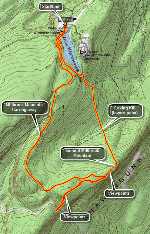
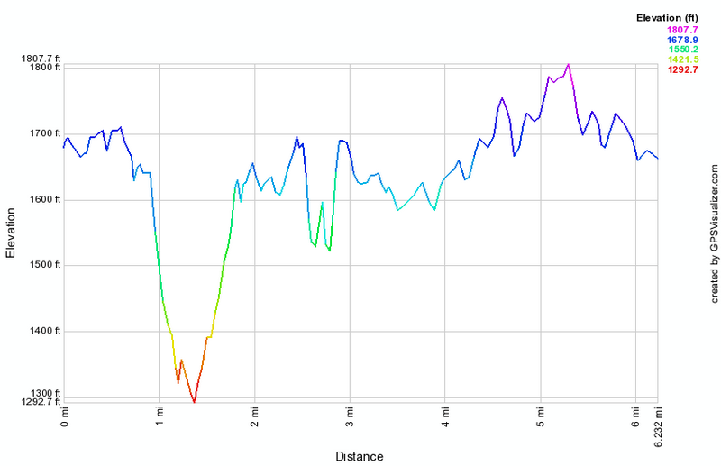
Park at the main parking area for Lake Minnewaska State Park. Walk to the lake and down the Lake Minnewaska Carriageway to the left. Continue on the carriageway as it runs along the western shore of the lake. At the southern end of Lake Minnewaska watch for the red Millbrook Mountain Trail heading south. Over the next .7 miles the trail descends over 350 feet to The Coxing Kill. It then start to ascend up to Millbrook Mouton gaining back the 350 feet in .5 miles. At this point you may walk out along the ridge on the Gertrude's Nose trail for a bit for more spectacular views. Return to Millbrook Mountain and turn onto the yellow Millbrook Mountain Carriageway which initially heads west and south but then loops around to head northeast back to the lake. The carriageway is almost flat gaining a little over 125 feet in 2.8 miles before descending back to the lake. Be sure to take a look at Patterson's Pellet, a large glacial erratic, along the way.
(The image above shows the profile of the hike. Remember that all vertical profiles are relative!)
Minnewaska: Millbrook Mountain from the Trapps
| Quick Look | ||||
|---|---|---|---|---|
| Difficulty | Round trip | Total climb | Internet Maps | |
| 7.9 mi | 1100 ft | AllTrails | ||
WARNING: The Town of Gardiner appears to be issuing parking tickets for cars parked at The Trapps lot for longer than a half hour.
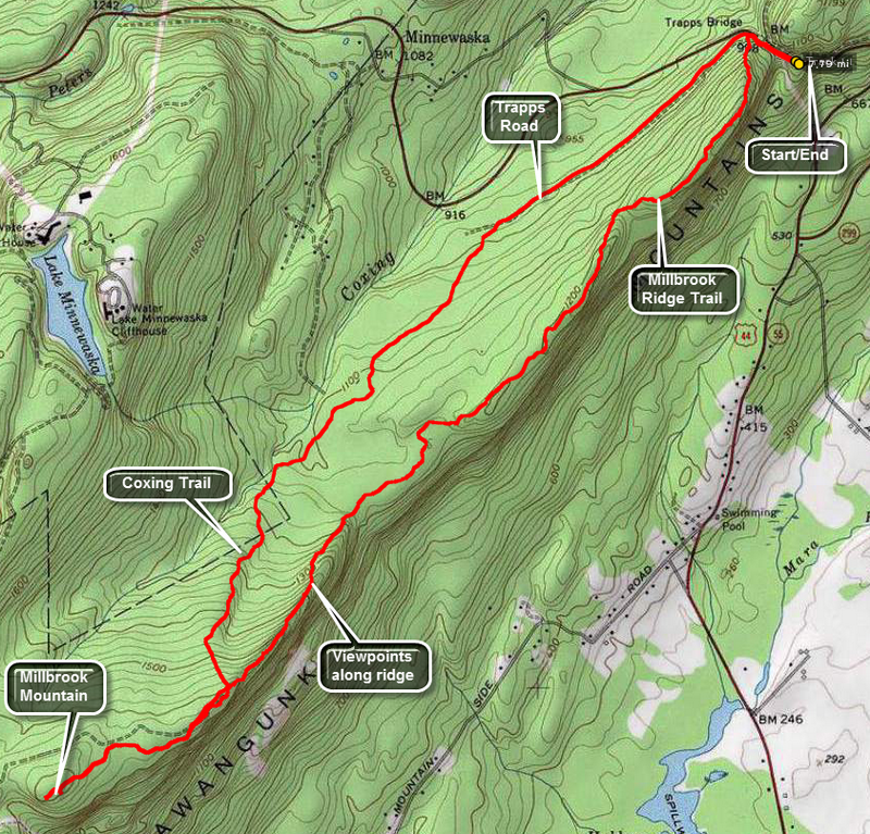
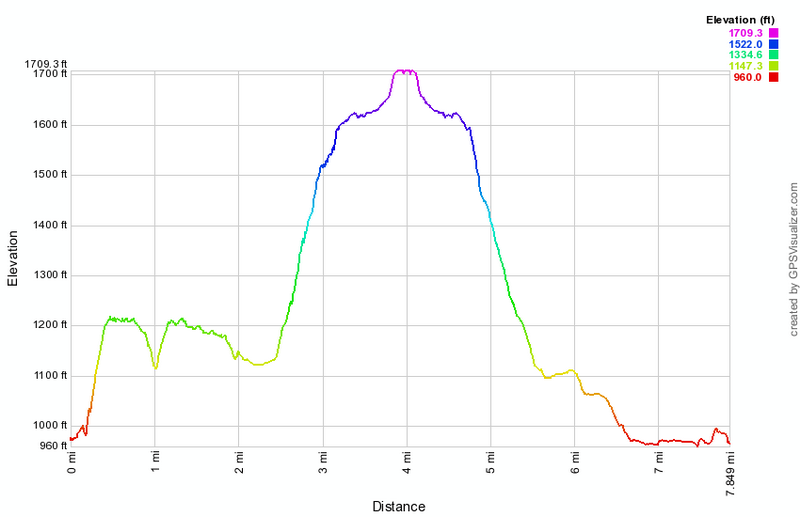
Park at the Trapps parking area on Route 44/55 or, as an alternative, park at the Mohonk Preserve Visitor's Center or the paid parking lot west of the iron bridge. Walk to the iron bridge and head up to the left to the carriageway. After a few hundred feet turn left and up the ridge on the Millbrook Mountain Trail. The trail has a few ups and downs over the next 2 miles but the main attraction are the views from several spots along the ridge. Over the next .8 miles the trail climbs 470 feet to Millbrook Mountain but the views are even more spectacular! Technically at this point you are at the point marked as Millbrook Mountain but there are more views ahead if you stay on the trail for another .7 miles. When you return to Millbrook Mountain, you can simply retrace your path to the parking area but this is a little boring. Turn north on the red Millbrook Mountain Trail and start to descend. In the middle of this descent watch for the blue Coxing Kill Trail on the right. Turn onto this trail which descends for 1.75 miles until it meets the Trapps Road. You may want to avoid this trail in wet weather as the lower part can be very wet. Turn right on the Trapps Road which will return you to the iron bridge in about 1 mile.
 (The image at the left shows the profile of the hike. Remember that all vertical profiles are relative!)
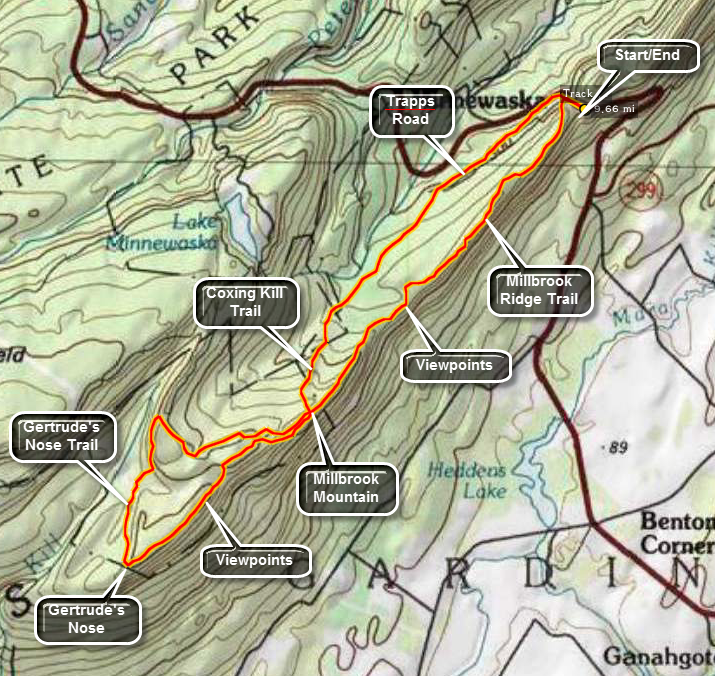
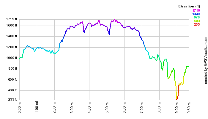
Minnewaska: Millbrook Ridge and Gertrude's Nose (Loop)
| Quick Look | ||||
|---|---|---|---|---|
| Difficulty | Round trip | Total climb | Internet Maps | |
| 9.7 mi | 1490 ft | AllTrails | ||
WARNING: The Town of Gardiner appears to be issuing parking tickets for cars parked at The Trapps lot for longer than a half hour.
Park at the Trapps parking area on Route 44/55 or, as an alternative, park at the Mohonk Preserve Visitor's Center or the paid parking lot west of the iron bridge. Walk up to the Bridge and follow the "To Trails" signs. Look for the blue blazes for the Millbrook Ridge Trail on your right after a VERY SHORT distance. This trail ascends Millbrook Ridge and heads toward the highest point called Millbrook Mountain. You will pass several intersecting trails on your right, most notably Bayard's and Millbrook Mountain Trail. Keep to your left on the ridge and continue following the blue blazes for about 2.7 miles. Stop to take in the wonderful views of the valleys and mountains beyond. The walk is sometimes along the cliff edge and at other times through the forest further in from the ridge line. As you get closer to Millbrook Mountain the ascent becomes steeper and more difficult as it traverses rocky outcroppings. You may be fooled several times into thinking you are at the top! At the intersection of the Millbrook Ridge Trail and the red Millbrook Mountain Trail is the highest point on the ridge, Millbrook Mountain. The Millbrook Mountain Carriageway also meets these trails at this point. The maps indicate that the Gertrude's Nose Trail starts here with red blazes. The blue blazes actually continue with few if any red blazes until you reach the Nose. You will hike for about another 1.7 miles until the trail opens onto a exposed rock face.
Gertrude's Nose is an amazing rock formation with deep cracks and spectacular views of the surrounding valley and mountain ranges. There are easier ways to get to the Nose but the Millbrook Ridge is the most fun! Follow the red blazes as they lead you past many steep dropoffs and some additional cracks and crevices. Be careful as many of the cracks are deep and wide enough to accommodate a person! The walk along the exposed rocks continues for about .5 miles as the trail descends slightly to a small ravine before climbing again. The climb involves several short but sometimes steep areas and ends at the yellow blazed Millbrook Mountain Carriageway after about .5 miles. Turning left here will take you on a longer route to Patterson's Pellet overlooking Lake Minnewaska and almost to the shores of the lake itself. It then joins the Millbrook Mountain Trail. This is definitely the LONGEST way back so TURN RIGHT on the carriageway to ascend Millbrook Mountain again. This time the ascent is very gentle compared to the last time! At the top turn left onto the red blazed Millbrook Mountain Trail. Watch for the blue blazes of the Coxing Trail on your right in less than .2 miles. This trail is often wet after it rains and you may want to return the same way you came up on the Millbrook Ridge Trail. Follow the Coxing Trail for 1.6 miles until it meets Trapps Road. Turn right here on this wide carriageway and walk 1.0 miles back to the bridge. From here walk down the shoulder of Route 55 to the parking area.
 (The image at the left shows the profile of the hike. Remember that all vertical profiles are
relative!)
(The image at the left shows the profile of the hike. Remember that all vertical profiles are
relative!)
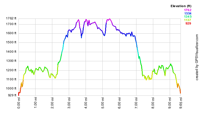
Minnewaska: Millbrook Ridge and Gertrude's Nose (Out and Back)
| Quick Look | ||||
|---|---|---|---|---|
| Difficulty | Round trip | Total climb | Internet Maps | |
| 9.7 mi | 1632 ft | AllTrails | ||
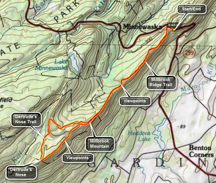 A variation of this hike is to stay on the Millbrook Ridge Trail when you arrive at Millbrook Mountain. This adds about 150 feet to the climbing distance and .1 miles to the hike. It is drier than the Coxing Trail in wet weather. Descending Millbrook Mountain can be challenging because of the sometimes steep descents on the open rock faces.
Park at the Trapps parking area on Route 44/55 or, as an alternative, park at the Mohonk Preserve Visitor's Center or the paid parking lot west of the iron bridge. Walk up to the Bridge and follow the "To Trails" signs. Look for the blue blazes for the Millbrook Ridge Trail on your right after a VERY SHORT distance. This trail ascends Millbrook Ridge and heads toward the highest point called Millbrook Mountain. You will pass several intersecting trails on your right, most notably Bayard's and Millbrook Mountain Trail. Keep to your left on the ridge and continue following the blue blazes for about 2.7 miles. Stop to take in the wonderful views of the valleys and mountains beyond. The walk is sometimes along the cliff edge and at other times through the forest further in from the ridge line. As you get closer to Millbrook Mountain the ascent becomes steeper and more difficult as it traverses rocky outcroppings. You may be fooled several times into thinking you are at the top! At the intersection of the Millbrook Ridge Trail and the red Millbrook Mountain Trail is the highest point on the ridge, Millbrook Mountain. The Millbrook Mountain Carriageway also meets these trails at this point. The maps indicate that the Gertrude's Nose Trail starts here with red blazes. The blue blazes actually continue with few if any red blazes until you reach the Nose. You will hike for about another 1.7 miles until the trail opens onto a exposed rock face.
Gertrude's Nose is an amazing rock formation with deep cracks and spectacular views of the surrounding valley
and mountain ranges. There are easier ways to get to the Nose but the Millbrook Ridge is the most fun! Follow the
red blazes as they lead you past many steep dropoffs and some additional cracks and crevices. Be careful as many of the cracks are deep and wide enough to accommodate a person! The walk along the exposed rocks continues for about .5 miles as the trail descends slightly to a small ravine before climbing again. The climb involves several short but sometimes steep areas and ends at the yellow blazed Millbrook Mountain Carriageway after about .5 miles.
Turning left here will take you on a longer route to Patterson's Pellet overlooking Lake Minnewaska and almost to
the shores of the lake itself. It then joins the Millbrook Mountain Trail. This is definitely the LONGEST way back so TURN RIGHT on the carriageway to
ascend Millbrook Mountain again. This time the ascent is very gentle compared to the last time! At the top the red blazed Millbrook Mountain Trail turns left. Continue straight ahead on the MillbrookRidge Trail and hike 2.7 miles back to the iron Bridge. From here walk down the shoulder of Route 55 to the parking area.
 (The image at the left shows the profile of the hike. Remember that all vertical profiles are
relative!)
(The image at the left shows the profile of the hike. Remember that all vertical profiles are
relative!)
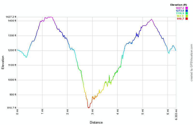
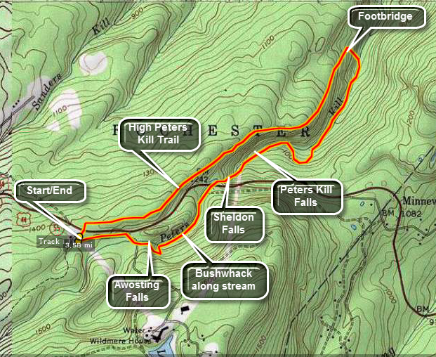
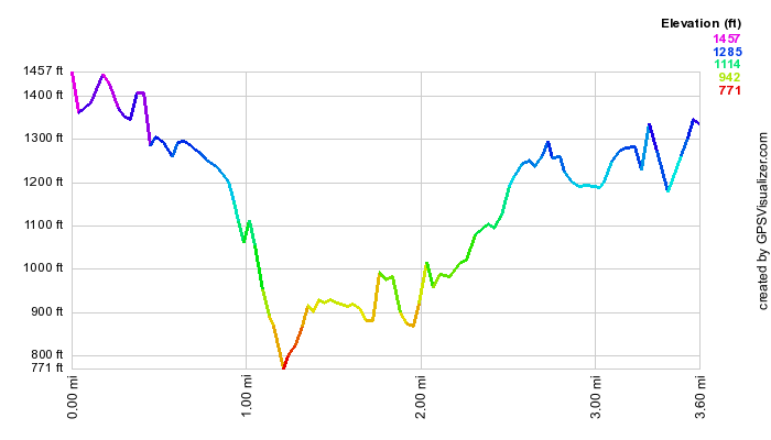
Minnewaska: Peters Kill from Jenny Lane
| Quick Look | ||||
|---|---|---|---|---|
| Difficulty | Round trip | Total climb | Internet Maps | |
| 6.3 mi | 1030 ft | AllTrails | ||
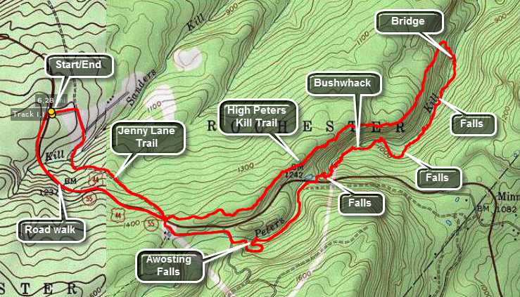 Park at the Jenny Lane parking area on Routes 44/55 on the left just before the main entrance to the park heading toward New Paltz. Walk down the road and follow the blazed trail for about a mile where the trail comes out to the road. This is where the High Peters Kill Trail begins. This trail follows the ridge along the Peters Kill as it works its way down to the stream. Along the way there will be views to Mohonk and beyond. You may be able to hear the stream at times and catch a glimpse of it below. The walk along the trail is a little less than two miles and drops 600 feet before crossing a bridge. The trail continues along the Peters Kill but another option is to bushwhack up the stream bed and along the banks. This is the best way to take in all the interesting sites. There are several small falls with two of the larger ones near where the stream crosses under the road about 1.4 miles from the bridge you crossed. The last falls has the highest drop but the volume is usually small. A little below this at the penultimate falls there is an old power generation plant. Still visible are the wooden pipers and some of the controls can be seen inside the building. When you reach the road cross over to the Awosting Falls Carriageway. Within half a mile from the road, you will be at the falls. Follow the carriageway up to the main gatehouse. You may walk the trail back to the car or simply use the road.
 (The image at the left shows the profile of the hike. Remember that all vertical profiles are relative!)
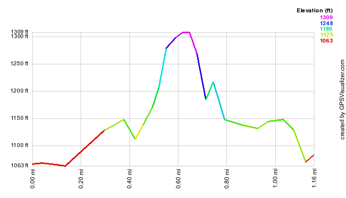
Minnewaska: Stony Kill Falls
| Quick Look | ||||
|---|---|---|---|---|
| Difficulty | Round trip | Total climb | Internet Maps | |
| 1.2 mi | 218 ft | AllTrails | ||
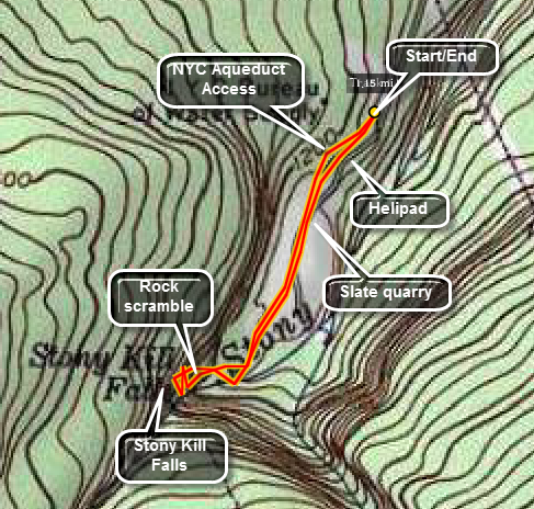 Begin on Route 44/55 that runs from Route 209 toward Gardiner and New Paltz. Watch for the sign for the Hudson valley
Resort. Across from this sign turn onto Minnewaska Trail. Quickly make a left turn onto Rock Haven Road. Follow this
road until it narrows and the pavement deteriorates. Turn left on Shaft 2A Road. Drive to the end and park by the
gate. Notice that parking is VERY limited. Do NOT park others in! Go around the gate and head down the dirt road.
Notice the fenced in area on the right. This is Shaft 2A which is an access shaft to the aqueduct that carries water
from the mountains to New York City. Across from the shaft is an old helipad. Con tune walking through the
abandoned slate quarry toward the opposite side. At this point any "formal" trail ends but you will be on the
banks of the Stony Kill. Turn right and pick your way upstream. You may cross the stream at several points. Within
minutes you can hear and then see the Stony Kills Falls. The water drops over 80 from the top of a cliff to a
pool below. The volume varies with the season and the rainfall but at any time it is still beautiful. Explore the
bottom of the falls and the pool. be careful since the rocks can be slippery from being wet, being icy, or being
covered with moss. When you are done exploring, retrace your steps to the car
Begin on Route 44/55 that runs from Route 209 toward Gardiner and New Paltz. Watch for the sign for the Hudson valley
Resort. Across from this sign turn onto Minnewaska Trail. Quickly make a left turn onto Rock Haven Road. Follow this
road until it narrows and the pavement deteriorates. Turn left on Shaft 2A Road. Drive to the end and park by the
gate. Notice that parking is VERY limited. Do NOT park others in! Go around the gate and head down the dirt road.
Notice the fenced in area on the right. This is Shaft 2A which is an access shaft to the aqueduct that carries water
from the mountains to New York City. Across from the shaft is an old helipad. Con tune walking through the
abandoned slate quarry toward the opposite side. At this point any "formal" trail ends but you will be on the
banks of the Stony Kill. Turn right and pick your way upstream. You may cross the stream at several points. Within
minutes you can hear and then see the Stony Kills Falls. The water drops over 80 from the top of a cliff to a
pool below. The volume varies with the season and the rainfall but at any time it is still beautiful. Explore the
bottom of the falls and the pool. be careful since the rocks can be slippery from being wet, being icy, or being
covered with moss. When you are done exploring, retrace your steps to the car
 (The image at the left shows the profile of the hike. Remember that all vertical profiles are
relative!)
(The image at the left shows the profile of the hike. Remember that all vertical profiles are
relative!)
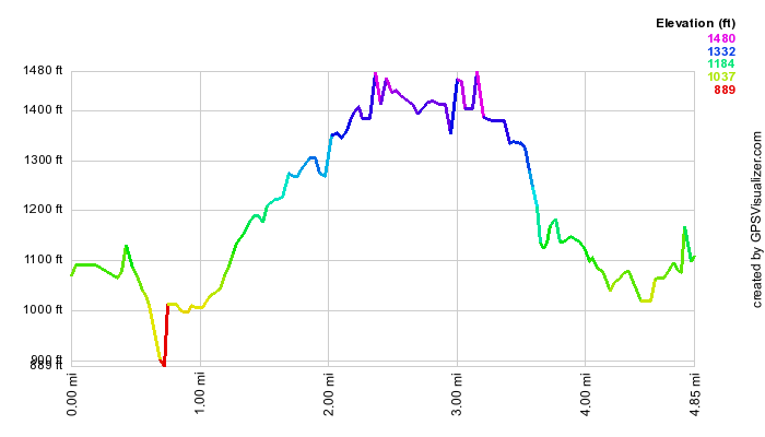
Minnewaska: Three Falls on the Peters Kill (Minnewaska Parking)
| Quick Look | ||||
|---|---|---|---|---|
| Difficulty | Round trip | Total climb | Internet Maps | |
| 3.6 mi | 680 ft | AllTrails | ||
 Park at the Lake Minnewaska lower parking area on Routes 44/55. Walk back to the gatehouse and turn right. Cross
the small bridge on the road which spans the Peters Kill. Turn left on the Awosting Falls Carriageway. Within half
a mile from where you parked, you will be at the falls. Follow the carriageway down to the base of the falls for
an even more impressive view! Continue on the carriageway until you can see the stream going under Routes 44/55.
At this point cross the road and follow the stream. You will almost immediately be at Sheldon Falls. Continue
along the south and east side of the stream. There is no trail for some time but several paths are obvious. In
about .2 miles you will see the ruins of a stone building. This is an old power plant. At some point, depending on
your individual route, you will pick up a red-marked trail. About .2 miles passed the power plant is
Peters Kill Falls. The red trail turns to a yellow one for a short distance and this ends at the blue-blazed
High Peters Kill Trail. Cross the bridge here and get ready for a 400 to 500 foot climb onto the ridge. The climb
is eased by many twists and turns. Continue on this trail back to the parking area. The total distance from the
bridge to the parking area is about 1.6 miles.
Park at the Lake Minnewaska lower parking area on Routes 44/55. Walk back to the gatehouse and turn right. Cross
the small bridge on the road which spans the Peters Kill. Turn left on the Awosting Falls Carriageway. Within half
a mile from where you parked, you will be at the falls. Follow the carriageway down to the base of the falls for
an even more impressive view! Continue on the carriageway until you can see the stream going under Routes 44/55.
At this point cross the road and follow the stream. You will almost immediately be at Sheldon Falls. Continue
along the south and east side of the stream. There is no trail for some time but several paths are obvious. In
about .2 miles you will see the ruins of a stone building. This is an old power plant. At some point, depending on
your individual route, you will pick up a red-marked trail. About .2 miles passed the power plant is
Peters Kill Falls. The red trail turns to a yellow one for a short distance and this ends at the blue-blazed
High Peters Kill Trail. Cross the bridge here and get ready for a 400 to 500 foot climb onto the ridge. The climb
is eased by many twists and turns. Continue on this trail back to the parking area. The total distance from the
bridge to the parking area is about 1.6 miles.
 (The image at the left shows the profile of the hike. Remember that all vertical profiles are
relative!)
(The image at the left shows the profile of the hike. Remember that all vertical profiles are
relative!)
Minnewaska: Three Falls on the Peters Kill (Peters Kill Parking)
| Quick Look | ||||
|---|---|---|---|---|
| Difficulty | Round trip | Total climb | Internet Maps | |
| 4.6 mi | 980 ft | AllTrails | ||
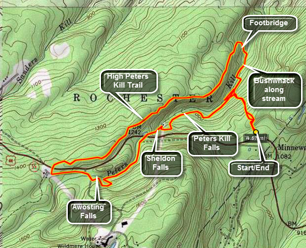 A slightly different approach to this same loop is shown here. Park at the Peters Kill parking area on Routes 44/55.
Walk back to the picnic area and go straight ahead on the red blazed Peters Kill Loop Trail. Descend a rather long
steep hill to the Peters Kill. As you start your walk you will notice "Climbers Only!" areas to the right and left.
Look ahead as you descend the hill for a nice view of the distance peaks and ridges. At the base of the hill turn
right on a yellow blazed trail. Follow this along the Peters Kill until it intersects with the blue blazed Peters
Kill High Trail. Turning right leads to the Lost City which is a series of high stone monoliths that are a favorite
of climbers. Cross the bridge here and get ready for a 400 to 500 foot climb onto the ridge. The climb
is eased by many twists and turns. Continue on this trail back to the parking area. The total distance from the
bridge to the lower Minnewaska parking area is about 1.6 miles. Be sure to take in the views of the opposite rim of
the gorge. When the leaves are few the Peters Kill sometimes can be spotted below. A view of the Trapps also presents
itself at one point. Cross Routes 44/55 with great care and enter the lower Minnewaska parking area. Follow the road
to the gatehouse and turn right. Cross the small bridge on the road which spans the Peters Kill. Turn left on the
Awosting Falls Carriageway. Within half a mile , you will be at the top of the falls. Follow the carriageway down to
the base of the falls for an even more impressive view! Continue on the carriageway until you can see the stream
going under Routes 44/55. At this point cross the road and follow the stream. You will almost immediately be at
Sheldon Falls. These falls are a series of cascades over some well-worn rock formations. Continue carefully picking
your way along the south and east side of the stream. There is no trail for some time but several paths are obvious.
The rocks may be slippery at times and several areas require some balance and jumping (landing) ability. In
about .2 miles you will see the ruins of a stone building. This is an old coal-fired power plant. At some point,
depending on your individual route, you will pick up a red-marked trail. About .2 miles passed the power plant is
Peters Kill Falls. The red trail then meets up with the red-blazed trail back to the parking area.
A slightly different approach to this same loop is shown here. Park at the Peters Kill parking area on Routes 44/55.
Walk back to the picnic area and go straight ahead on the red blazed Peters Kill Loop Trail. Descend a rather long
steep hill to the Peters Kill. As you start your walk you will notice "Climbers Only!" areas to the right and left.
Look ahead as you descend the hill for a nice view of the distance peaks and ridges. At the base of the hill turn
right on a yellow blazed trail. Follow this along the Peters Kill until it intersects with the blue blazed Peters
Kill High Trail. Turning right leads to the Lost City which is a series of high stone monoliths that are a favorite
of climbers. Cross the bridge here and get ready for a 400 to 500 foot climb onto the ridge. The climb
is eased by many twists and turns. Continue on this trail back to the parking area. The total distance from the
bridge to the lower Minnewaska parking area is about 1.6 miles. Be sure to take in the views of the opposite rim of
the gorge. When the leaves are few the Peters Kill sometimes can be spotted below. A view of the Trapps also presents
itself at one point. Cross Routes 44/55 with great care and enter the lower Minnewaska parking area. Follow the road
to the gatehouse and turn right. Cross the small bridge on the road which spans the Peters Kill. Turn left on the
Awosting Falls Carriageway. Within half a mile , you will be at the top of the falls. Follow the carriageway down to
the base of the falls for an even more impressive view! Continue on the carriageway until you can see the stream
going under Routes 44/55. At this point cross the road and follow the stream. You will almost immediately be at
Sheldon Falls. These falls are a series of cascades over some well-worn rock formations. Continue carefully picking
your way along the south and east side of the stream. There is no trail for some time but several paths are obvious.
The rocks may be slippery at times and several areas require some balance and jumping (landing) ability. In
about .2 miles you will see the ruins of a stone building. This is an old coal-fired power plant. At some point,
depending on your individual route, you will pick up a red-marked trail. About .2 miles passed the power plant is
Peters Kill Falls. The red trail then meets up with the red-blazed trail back to the parking area.
 (The image at the left shows the profile of the hike. Remember that all vertical profiles are
relative!)
(The image at the left shows the profile of the hike. Remember that all vertical profiles are
relative!)
Minnewaska: Tunnel Loop
| Quick Look | ||||
|---|---|---|---|---|
| Difficulty | Round trip | Total climb | Internet Maps | |
| 7.8 mi | 1364 ft | AllTrails | ||
 Park at the Lake Minnewaska upper parking area on Routes 44/55. Walk to the upper end of the lake and turn right
toward the western shore of the lake. After walking down the hill, turn left and walk on the carriageway around
the lake. Pass the turn to the Upper Awosting Carriageway(green)) and the next one to the Castle Point Carriageway
(blue). At the next Y in the path turn right onto the yellow-blazed Hamilton Point Carriageway. Continue on this
path and you will pass Echo Rock and several other good lookouts over the Palmaghatt Ravine. Of course the best
views are from Hamilton Point itself which is about 3 miles from the parking area.
Park at the Lake Minnewaska upper parking area on Routes 44/55. Walk to the upper end of the lake and turn right
toward the western shore of the lake. After walking down the hill, turn left and walk on the carriageway around
the lake. Pass the turn to the Upper Awosting Carriageway(green)) and the next one to the Castle Point Carriageway
(blue). At the next Y in the path turn right onto the yellow-blazed Hamilton Point Carriageway. Continue on this
path and you will pass Echo Rock and several other good lookouts over the Palmaghatt Ravine. Of course the best
views are from Hamilton Point itself which is about 3 miles from the parking area.
Keep on the yellow path as it descends down after Hamilton Point. After a walk of less than one mile the Castle Point Carriageway branches to the right and ascends to Castle Point. The Long Path (aqua) turns left into the woods. Continue on the yellow path for about half a mile until and unmarked but obvious trail turns to the left. This trail passes under the Wolf's Jaw. Just after the Wolf's Jaw watch for the aqua blazes of the Long Path on the left. Turn onto the Long Path and cross the small stream. The trail immediately begins to wind its way upwards back to the junction on the Hamilton Point Carriageway. The most interesting point along the way is The Tunnel. The passageway is narrow but very short. It can be wet and, unless you are willing to get very low, packs may be a problem. The trail then makes several rather significant ascents spaced with a few flat areas before you are back a the carriageway.
Turn right and follow the yellow and aqua blazes for about 500 feet. At this point the Long Path turns left into the woods. Be prepared to do some real climbing. You must be able to get some good hand and footholds and pull yourself up in several places. The reward is an exhilarating feeling when you get to the wonderful views on top of Castle Point. From here you can see Lake Awosting, the Sam's Point Preserve and you can look across the ravine at the Gertrude's Nose trail and Millbrook Mountain. Follow the blue-blazed carriageway for about 4 miles back to the parking area. Along the way take in some of the views from Kempton ledge and other unnamed viewpoints. As you approach the lake a view open up on the left. Several Catskill peaks can be seen even when a haze is lying on them.
 (The image at the left shows the profile of the hike. Remember that all vertical profiles are
relative!)
(The image at the left shows the profile of the hike. Remember that all vertical profiles are
relative!)
Mohonk: Coxing and Old Minnewaska Trail
| Quick Look | ||||
|---|---|---|---|---|
| Difficulty | Round trip | Total climb | Internet Maps | |
| 5.2 mi | 900 ft | AllTrails | ||
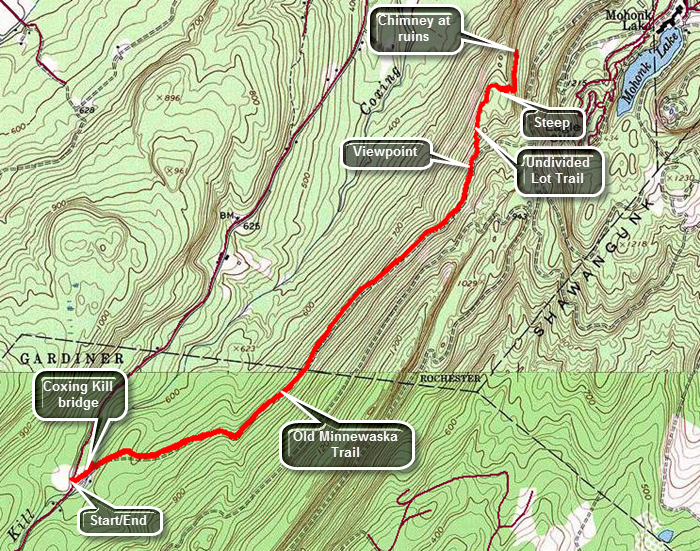 From Route 209, turn onto Route 44/55 heading over the mountain toward New Paltz. Pass the main entrance to Minnewaska Park and continue until Trapps Road appears on the left just after the Minnewaska park office. At the intersection with Clove Road turn left and drive down to the Coxing Trailhead. If the lot is open, drive in and park. To park here you must be a member of the Mohonk Preserve or pay a $12 per person usage fee. If the gates are closed, be sure to park so you are not blocking the entrance. Cross the road to get on the wide Old Minnewaska Trail heading toward the bridge over the Coxing Kill. After crossing the Coxing Kill ,the Old Minnewaska Trail ascends gently with a few rolling stretches. At about .7 miles there is a spot which was the site of a bridge that once spanned a stream. There isn't much of a stream left and the bridge no longer exists. Descend the bank and then ascend the other side. Soon some views to the north and west appear to the left of the trail although there are trees blocking the view. Several unobstructed views open up and you may stop if you wish. At about f2 miles there is a sign indicating that the Old Minnewaska Trail continues straight ahead and the Undivided Lot Trail turns to the left. H to the left as the trail turns from a woods road to a trail along open rock faces. Immediately begin to descend over rock outcroppings losing about 150 feet of elevation until you are at the base of a cliff band. The trail follows a route that ascended along and through the cliffs. In most seasons this is a short and easy ascent. In winter it can be more challenging! The climb begins at about 2.4 miles and is only 80 feet of vertical gain but it is a 25% grade. Soon the trail levels at the top and you can see a stone chimney ahead which is the turn around point. Walk to the chimney and then turn around and begin the return trip. The descent of the cliffs is easier than the ascent even in winter. You may want to stop at some of the unobstructed lookouts as the view is breathtaking. At 3.1 miles turn right to get on the Old Minnewaska Trail. The trail ascends briefly before beginning the long descent toward the trailhead. At 5 miles cross the bridge over the Coxing Kill. You may want to walk a little downstream to get a view of the bridge. Back on the main trail walk over to the kiosk and read some of the information about the Smiley family and the ecology of the Coxing Kill. Walk back to the car at the trailhead parking.
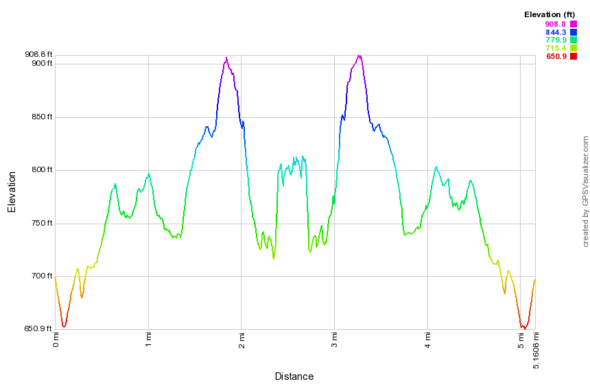 (The image shows the profile of the hike. Remember that all vertical profiles are relative!)
Mohonk: Overcliff - Sky Top - Undercliff
| Quick Look | ||||
|---|---|---|---|---|
| Difficulty | Round trip | Total climb | Internet Maps | |
| 7.2 mi | 1250 ft | AllTrails | ||
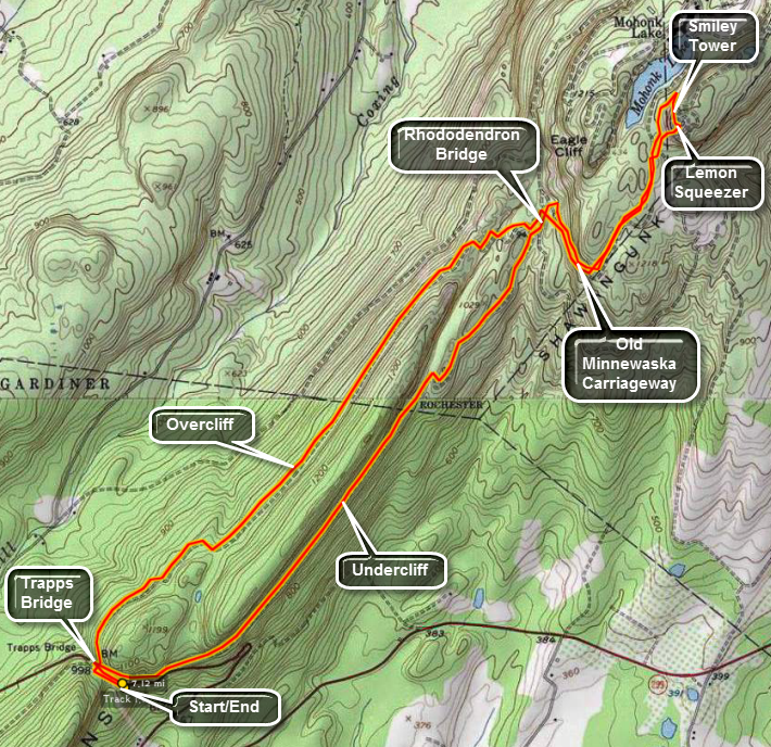 Park at the Trapps parking area on Routes 44/55 just before the hairpin turn. Walk up the road and cross the Trapps
Bridge. At the fork in the path, turn left onto the Overcliff Carriageway. The signs are generally informative
but DO NOT always match the descriptions in the guidebooks or the names used on maps. After about 2.5 miles Overcliff
ends at the Rhododendron Bridge. Cross the Bridge and turn left on the Old Minnewaska Carriageway. Do not make any
turns off this path for at least a mile. The carriageway begins to ascend and makes some turns right after the
bridge as it winds its way upward. There are some nice views along the way. Bypass the left turn onto Long
Woodland Drive and the right onto Home Farm Road. Shortly after this Short Woodland bears left and Lake Shore Road
goes right. Take the right onto Lake Shore and then the next right onto Forrest Drive. Look for the Spring House on
the left. Walk up the trail behind the spring house and watch for the red arrows that mark the path to the Crevice.
WARNING: The Crevice is narrow and steep. Climbing with a pack on your back may be impossible. There are ladders at
some points but other places require finding hand and foot holds. The last part is the hardest since it is the most
narrow and requires some strength to boost your body up onto the rock ledge at the top. You may use the Spring Path
route that is usually used as the return route. The Crevice is one way only up! See the end of this description.
At the top of the Crevice is a wide rock ledge that offers a great view of the surrounding area. You can also
look over the edge at the talus slopes below. A bridge over the Crevice offers a peek down into the depths you have
just conquered. The fun is not quite over. After crossing the bridge, another near vertical ascent is required. At
the top is a set of stairs and the paths to the Smiley Tower. The Tower offers a 360 degree view of the area.
Perhaps the most striking view is of Mohonk Lake and the Mohonk Mountain House. From the Tower head to the opposite
side from the crevice. Head down Sky Top Path to the stairs down to the Labyrinth. Along this short .2 mile path
are several gazebos and benches that overlook the lake. The path through the labyrinth is marked by the red arrows
that lead to the Crevice. You may follow these or go down to the Spring Path to make life easier. If you want to
avoid the Crevice altogether you may use the Spring Path to get to the Tower and then retrace your steps back to the
spring on the same path. The spring is only about .25 miles from the stairs. Return on from the spring to the
Rhododendron Bridge the same way you came. This distance is about one miles. Turn left over the Bridge on the
Undercliff Carriageway. In 2.3 miles you will be back at the Trapps Bridge. Along the way watch for groups climbing
the cliffs and boulders along the trail. This is a favorite spot for climbers from all around.
Park at the Trapps parking area on Routes 44/55 just before the hairpin turn. Walk up the road and cross the Trapps
Bridge. At the fork in the path, turn left onto the Overcliff Carriageway. The signs are generally informative
but DO NOT always match the descriptions in the guidebooks or the names used on maps. After about 2.5 miles Overcliff
ends at the Rhododendron Bridge. Cross the Bridge and turn left on the Old Minnewaska Carriageway. Do not make any
turns off this path for at least a mile. The carriageway begins to ascend and makes some turns right after the
bridge as it winds its way upward. There are some nice views along the way. Bypass the left turn onto Long
Woodland Drive and the right onto Home Farm Road. Shortly after this Short Woodland bears left and Lake Shore Road
goes right. Take the right onto Lake Shore and then the next right onto Forrest Drive. Look for the Spring House on
the left. Walk up the trail behind the spring house and watch for the red arrows that mark the path to the Crevice.
WARNING: The Crevice is narrow and steep. Climbing with a pack on your back may be impossible. There are ladders at
some points but other places require finding hand and foot holds. The last part is the hardest since it is the most
narrow and requires some strength to boost your body up onto the rock ledge at the top. You may use the Spring Path
route that is usually used as the return route. The Crevice is one way only up! See the end of this description.
At the top of the Crevice is a wide rock ledge that offers a great view of the surrounding area. You can also
look over the edge at the talus slopes below. A bridge over the Crevice offers a peek down into the depths you have
just conquered. The fun is not quite over. After crossing the bridge, another near vertical ascent is required. At
the top is a set of stairs and the paths to the Smiley Tower. The Tower offers a 360 degree view of the area.
Perhaps the most striking view is of Mohonk Lake and the Mohonk Mountain House. From the Tower head to the opposite
side from the crevice. Head down Sky Top Path to the stairs down to the Labyrinth. Along this short .2 mile path
are several gazebos and benches that overlook the lake. The path through the labyrinth is marked by the red arrows
that lead to the Crevice. You may follow these or go down to the Spring Path to make life easier. If you want to
avoid the Crevice altogether you may use the Spring Path to get to the Tower and then retrace your steps back to the
spring on the same path. The spring is only about .25 miles from the stairs. Return on from the spring to the
Rhododendron Bridge the same way you came. This distance is about one miles. Turn left over the Bridge on the
Undercliff Carriageway. In 2.3 miles you will be back at the Trapps Bridge. Along the way watch for groups climbing
the cliffs and boulders along the trail. This is a favorite spot for climbers from all around.
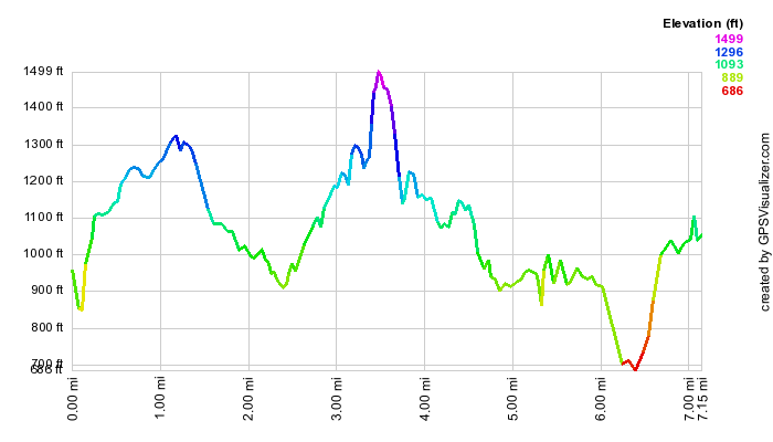 (The image at the left shows the profile of the hike. Remember that all vertical profiles are
relative!)
(The image at the left shows the profile of the hike. Remember that all vertical profiles are
relative!)
Mohonk: Spring Farm (Chapel and Undivided Lot)
| Quick Look | ||||
|---|---|---|---|---|
| Difficulty | Round trip | Total climb | Internet Maps | |
| 6.7 mi | 1538 ft | AllTrails | ||
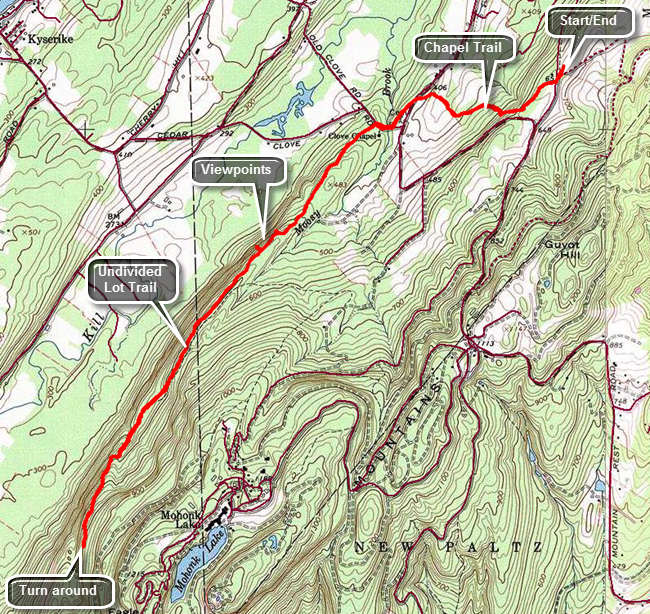
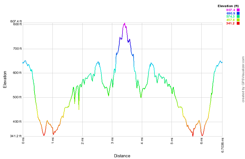 Just outside of New Paltz on Route 299 turn north on Springtown Road. After a short distance turn left onto Mountain Rest Road. Mountain Rest Road eventually becomes Mohonk Road. Continue passed the entrance to the Mohonk Mountain House. After about a mile, turn right on Upper Knolls Road at the sign for the Spring Farm Trailhead at the point where the main road makes a sweeping turn to the left. Stop at small gatehouse and show your membership pass or pay $12 each to hike. Park in the parking lot close to the gatehouse. Walk back toward the gatehouse and start out on Upper Knolls Road to begin your hike. Just passed the gatehouse, turn right onto the Chapel Trail which passes through a field to the woods. Walk through the woods and down a small hill to a stream crossing and then climb back up the other side. The trail climbs briefly and then starts another descent. After walking through some woods, the trail passes close to a field and along an elevated walkway. Ascend a small hill, crossed a powerline right-of-way and arrive at Mohonk Road. Cross to the other side bearing a little to the left to pick up the trail. The blazes on the trail may be faded in some spots and turns are not always clearly marked. After a short walk downhill, arrive at Clove Road and turn right walking west to a small parking area with a chapel on a hill. Continue west a short distance on the road until you find the triangle of blazes that is the start of the Undivided Lot Trail. Continue on the trail which ascends much of the way. Soon the red blazed Stokes Trail heads off to the left. Stay to the right on the blue Undivided Lot Trail. At 1.8 miles the trail comes very close to the edge of the ridge and there is a good view to the northwest. As is often the case, there is a better lookout a few hundred feet further along with a short path to the right. At 2.6 miles we begin a descent and then an ascent at 3.0 miles. The ascent isn't that steep but it seems to hang on the edge of the ridge with a steep dropoff on the right side. The trail starts to level off at the top and at about 3.5 miles there is a chimney to the left of the trail and an old foundation. This is the turn around point for this hike although you could continue farther or turn around earlier. To complete the hike reverse your route on the way out to make a true out-and-back hike.
(The image shows the profile of the hike. Remember that all vertical profiles are relative!)
Mountain Road to SRT
| Quick Look | |||
|---|---|---|---|
| Difficulty | Round trip | Total climb | Internet Maps |
| 3.6 mi. | 700 ft. | AllTrails | |
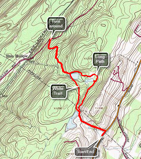 Take exit 113 off Route 17/I86 to get on Route 209 south toward Port Jervis. Drive south to the Guymard Turnpike which is a sharp left turn about 1.7 miles south of the junction with Route 211. Follow the winding road over the ridge to Mountain Road. Turn right on Mountain Road and drive 3 miles south to the trailhead on the right. Park slightly south of the beginning of the trail where there is a pullout that can accommodate three or four cars. Walk north along Mountain Road and through a break in the fence. The trail begins as a wide woods road and starts a gentle climb for the first .4 miles. Passed a gravel pit on the right and watch carefully for aqua blazes which are sparse. After .4 miles there is a small pond with a concrete dam impounding the water. A white blazed trail crosses the dam at this point. From the pond continue on the Long Path heading first northeast and then northwest. The trail begins a gentle descent. At .9 miles there is another small pond. Just after this pond make a 90 degree turn to the left still following the Long Path. At 1.2 miles there is yet another pond where you will find the other end of the white trail. The Long Path begins to descend still following woods roads. Over the next .7 miles the trail descends a little over 350 feet until it intersects the Shawangunk Ridge Trail. "Tag" the SRT and then turn around to head back to the car. Ascend the ridge and at 2.7 miles you will be back at the last pond. You may continue to follow the Long Path back to the car. For some variety, turn right and start to follow the white trail. It also follows a road and from it you can see the Long Path as the trails are parallel at times. Cross a gas pipeline right-of-way and arrive back at the first pond you visited. The white trail turns left here and passes over the dam to rejoin the Long Path. Walk back down the woods road to Mountain Road and turn right to get back to the car.
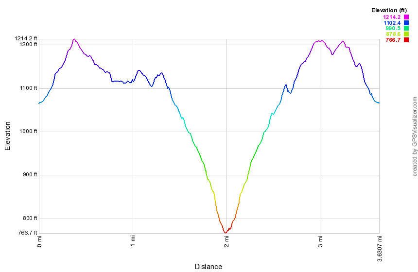 (The image shows the profile of the hike. Remember that all vertical profiles are relative!)
Sam's Point: All Points
| Quick Look | ||||
|---|---|---|---|---|
| Difficulty | Round trip | Total climb | Internet Maps | |
| 10.3 mi. | 1403 ft. | AllTrails | ||
 The hiking trails throughout the Sam's Point Preserve vary from open carriageway to narrow "maintained"
trails through the brush, over the bogs and around many interesting rock formations. There are
several different variations in length from the trail through the Ice Caves and to Sam's Point which
is about 4 miles to the 10.5 mile complete loop. The ecology is a pine barrens with some hardwood
sections and many boggy areas. Verkeerder Kill falls is well worth the visit as are the Ice Caves.
These "caves" are actually tectonic caves formed when part of the mountain pulled away forming
deep crevices in the rock.
The hiking trails throughout the Sam's Point Preserve vary from open carriageway to narrow "maintained"
trails through the brush, over the bogs and around many interesting rock formations. There are
several different variations in length from the trail through the Ice Caves and to Sam's Point which
is about 4 miles to the 10.5 mile complete loop. The ecology is a pine barrens with some hardwood
sections and many boggy areas. Verkeerder Kill falls is well worth the visit as are the Ice Caves.
These "caves" are actually tectonic caves formed when part of the mountain pulled away forming
deep crevices in the rock.
Park in the lot at the Visitor's Center at Sam's Point. Be sure you pay the parking fee or buy a pass that is good for a year. As you walk toward the trails, you may bear to the left or right. Bear to the left and begin to hike up the loop road on a gentle grade. Watch on your left for some of the shacks used by blueberry pickers in years gone by. These shacks are all but gone but hark back to an era when berry picking was a commercial venture. At about .3 miles the South Gully Trail branches left off the loop road. This trail leads down to Route 52 and is a hike all by itself. There are several waterfalls and cascades along the trail as it parallels a stream. Continue to walk along the loop road. At about 1.0 mile there will be a short side trail that goes to the shore of Lake Maratanza. Depending on the level of the lake, this may or may not prove interesting. At this point you will start to see TV and other communications towers on your left. The High Point Carriageway bears to the left off the loop road at 1.2 miles. Bear left and at 1.6 miles turn left on the trail to Indian Rock. The Rock is a large glacial erratic from which there are very good views. The first part of this trail is a boardwalk since it passes over a bog. Continue to walk on the trail following the blazes on the rocks carefully. The blazes may be hard to follow but the trip is 1.0 mile detour is worth the effort. Back on the carriageway, continue north to 3.85 miles and turn right on the High Point Trail which makes a steep but short ascent. Near the top of this ascent is where the fire tower was located. Turn right to stay on the High Point Trail and walk through the scrub to High Point. A USGS marker is embedded in the rock at this location. Continue the hike by dropping down the ledge and walking the High Point Trail along the escarpment to 6.25 miles. Along the way there are some fantastic views! The Long Path continues straight ahead on its way to Lake Awosting. Turn right a make a steep descent on the Verkeerder Kill Falls Trail. At 6.5 miles you will be at the lowest point on the hike. Here you will be looking down into the ravine formed by the falls. The falls are best viewed when there has been some rain. Since you will now have to cross over the stream above the falls to continue the hike, avoid this route when there have been massive amounts of rain. Observing the falls from each side gives slightly different views. Continue on the trail and be prepared to hike UP the trail for the next 1.7 miles until the trail ends on the access road to the ice caves at 8.25 miles. Walk down the heavily eroded road to the entrance to the "caves". Walk carefully on the wooden ladders and rocky path through this area. Constant use has polished both wood and stone making it very slippery. Upon exiting the caves walk up the road to the loop road and turn left at 9.25 miles. Walk on the road until another side trail appears on the right. Walk this trail out to Sam's Point to take in more views and to see if you can spot your car in the lot. Walk back out to the main trail and down to the Visitor's Center and your car.
 (The image at the left shows the profile of the hike. Remember that all vertical profiles are
relative!)
(The image at the left shows the profile of the hike. Remember that all vertical profiles are
relative!)
Sam's Point: Around Lake Awosting
| Quick Look | ||||
|---|---|---|---|---|
| Difficulty | Round trip | Total climb | Internet Maps | |
| 13.6 mi. | 1755 ft. | AllTrails | ||
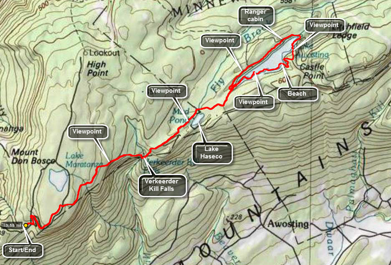 The hiking trails throughout the Sam's Point Preserve vary from open carriageway to narrow "maintained" trails through the brush, over the bogs and around many interesting rock formations. There are
several different variations in length from the trail through the Ice Caves and to Sam's Point which is about 4 miles to the 10.5 mile complete loop. The ecology is a pine barrens with some hardwood
sections and many boggy areas. Verkeerder Kill falls is well worth the visit as are the Ice Caves. These "caves" are actually tectonic caves formed when part of the mountain pulled away forming
deep crevices in the rock.
The hiking trails throughout the Sam's Point Preserve vary from open carriageway to narrow "maintained" trails through the brush, over the bogs and around many interesting rock formations. There are
several different variations in length from the trail through the Ice Caves and to Sam's Point which is about 4 miles to the 10.5 mile complete loop. The ecology is a pine barrens with some hardwood
sections and many boggy areas. Verkeerder Kill falls is well worth the visit as are the Ice Caves. These "caves" are actually tectonic caves formed when part of the mountain pulled away forming
deep crevices in the rock.
Park at the Visitors Center at the Sam's Point Preserve and start out on the Loop Road to the right. Hike up the Loop Road passing the spur trail to Sam's Point on the left. This hike is already long but you may visit the lookout if you wish. Turn right on the road that goes down to the ice caves. Turn then a left onto the Verkeerder Kill Falls Trail which has the aqua blazes of the Long Path. This trail has some beautiful views out over the flat valley on your right. Straight ahead on the trail you will see the cliffs of Castle Point and Hamilton Point at Minnewaska State Park and the blue waters of Lake Awosting. The trail drops 500 feet in about 1.75 miles to the lowest point on the hike at Verkeerder Kill Falls at 2.9 miles into the hike. There are lookouts on both sides of the falls. The falls are more interesting when there has been some rainfall but this makes crossing the stream above the falls more dangerous! After observing the falls from the far side, continue on the trail as it rises to a trail junction over the next .3 miles. Turn right to stay on the Long Path and head to Lake Awosting. Older maps show this part of the trail as "Closed" or "Do not enter" but the land has been purchased by the Preserve and is now open to the public. The trail at first passes over mostly open rock and hikers have constructed many small cairns along the way. After about 1.1 miles Mud Pond or Lake Haseco came into view at 3.9 miles with a nice viewpoint overlooking the water. As you continue on the trail, a path to the right goes down to the shore of the pond. Back on the trail there is a wooden walkway over some muddy areas and Fly Brook. After another mile at about 5 miles you will be at a lookout over Lake Awosting at the southwestern end of the lake. Follow the short side path to the left and down to the Lake Awosting Carriageway around the lake. This route leaves the aqua blazes of the Long Path and is marked in black. Turn right on the carriageway to walk anticlockwise around the largest of the three sky lakes. There are several nice viewpoints along the shore that offer points to take pictures. Some of the viewpoints are on areas of land that jut out into the lake which has an incredible deep blue color. You will pass by the stone "beach" and on the other side of the beach the carriageway ascends to viewpoints above the lake which are stunning! This will be at about 6.75 miles into your hike. Continue on the carriageway as it wraps around the outlet end of the lake and starts to head southwest. The path along the opposite shore of the lake is more direct. You will pass a ranger's cabin and then the final viewpoint near the end of the lake. Walk back up the path to return to the lookout over the lake and the aqua blazes of the Long Path. The lake is about 3.6 miles round and you will now be at about 8.6 miles into the hike. Follow the Long Path back to Verkeerder Kill Falls at 10.8 miles. Cross over the stream and begin a long 1.75 mile climb back to the road above the ice caves. The trail gains elevation and passes over a lot of uneven and large rocks which you may remember from the hike down to the falls. Turn right at the road and then left at the loop road to get back down to the Visitors Center.
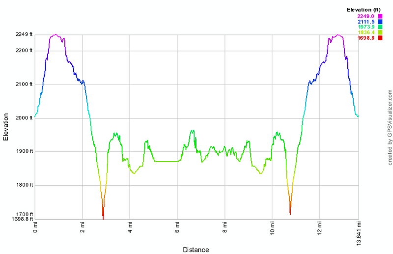 (The image at the left shows the profile of the hike. Remember that all vertical profiles are
relative!)
(The image at the left shows the profile of the hike. Remember that all vertical profiles are
relative!)
Sam's Point: Berme Road to Berrypickers Path
| Quick Look | |||
|---|---|---|---|
| Difficulty | Round trip | Total climb | Internet Maps |
| 5.8 mi | 445 ft | AllTrails | |
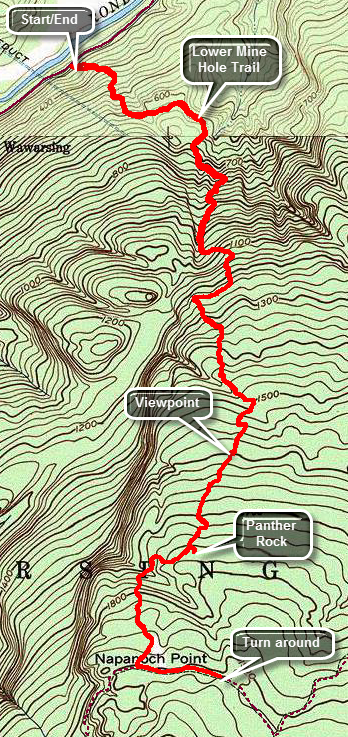 Take Route 52 through Ellenville heading east over the mountain. Just before the road began its trip up the mountain, turn left on Berme Road and drive about 4 miles to where the Long Path crosses the road. There is room for one or two cars to park on the side of the road. Follow the aqua blazes through hardwood forests consisting mostly of oak trees. The trail is pretty easy to follow as it uses woods roads and is pretty well marked. At .7 miles turn left on another woods road which is also marked as the Lower Mine Hole Trail coming up from Foordmore Road. The trail is rocky and layers of oak leaves can make it slippery underfoot. The trail heads south and continues climbing toward the ridge. At about 1.4 miles the trail turns west to avoid some ledges and then turns south again. At an elevation of about 1230 feet the typical Sam's Point and Shawangunk vegetation appears. There are now open rock faces with scrub pine and the transition is sudden and stunning. Keep looking back over your shoulder as viewpoints begin to appear. From some lookouts you can see the valley below and the mountains of the Catskills beyond to the north. Keep an eye out for the side trail on the right to Jacob's Ladder which you may want to visit. Also watch for a path on the left to Panther Rock which is a great lookout. The trail is marked with a sign saying "Panther Rock" and is blazed in white. It is only a few hundred feet out to Panther Rock but it is certainly worth the trip. Climb up to the top of Panther Rock and find views similar to other viewpoints but unobstructed and more expansive. Continue heading southwest and climbing. Just after Panther Rock descend a little and cross a stream before climbing again. At 3.4 miles you will hit the Smiley Carriageway. Turn left and walk to the beginning of the Berrypickers Trail which is only about a quarter mile away. Once you are at the beginning of the Berrypickers Path, head back down along the same path you used on the way up.
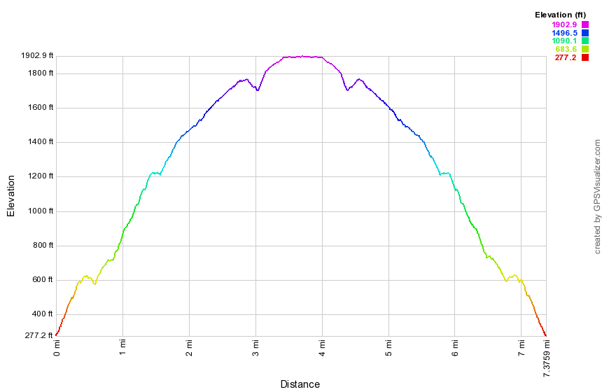
(The image shows the profile of the hike. Remember that all vertical profiles are relative!)
Sam's Point: Berrypickers Trail Double Loop
| Quick Look | ||||
|---|---|---|---|---|
| Difficulty | Round trip | Total climb | Internet Maps | |
| 10.9 mi. | 965 ft. | AllTrails | ||
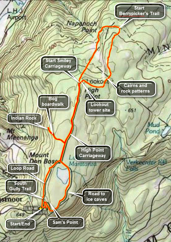 The hiking trails throughout the Sam's Point Preserve vary from open carriageway to narrow "maintained"
trails through the brush, over the bogs and around many interesting rock formations. There are
several different variations in length from the trail through the Ice Caves and to Sam's Point which
is about 4 miles to the 10.5 mile complete loop. The ecology is a pine barrens with some hardwood
sections and many boggy areas. Verkeerder Kill falls is well worth the visit as are the Ice Caves.
These "caves" are actually tectonic caves formed when part of the mountain pulled away forming
deep crevices in the rock.
The hiking trails throughout the Sam's Point Preserve vary from open carriageway to narrow "maintained"
trails through the brush, over the bogs and around many interesting rock formations. There are
several different variations in length from the trail through the Ice Caves and to Sam's Point which
is about 4 miles to the 10.5 mile complete loop. The ecology is a pine barrens with some hardwood
sections and many boggy areas. Verkeerder Kill falls is well worth the visit as are the Ice Caves.
These "caves" are actually tectonic caves formed when part of the mountain pulled away forming
deep crevices in the rock.
Park in the lot at the Visitor's Center at Sam's Point. Be sure you pay the parking fee or buy a pass that is good for a year. As you walk toward the trails, you may bear to the left or right. Bear to the left and begin to hike up the loop road on a gentle grade. Watch on your left for some of the shacks used by blueberry pickers in years gone by. These shacks are all but gone but hark back to an era when berry picking was a commercial venture. At about .3 miles the South Gully Trail branches left off the loop road. This trail leads down to Route 52 and is a hike all by itself. There are several waterfalls and cascades along the trail as it parallels a stream. Continue to walk along the loop road. At about 1.0 mile there will be a short side trail that goes to the shore of Lake Maratanza. Depending on the level of the lake, this may or may not prove interesting. At this point you will start to see TV and other communications towers on your left. The High Point Carriageway bears to the left off the loop road at 1.2 miles. Bear left and at 1.6 miles turn left on the trail to Indian Rock. The Rock is a large glacial erratic from which there are very good views. The first part of this trail is a boardwalk since it passes over a bog. Continue to walk on the trail following the blazes on the rocks carefully. The blazes may be hard to follow but the trip is 1.0 mile detour is worth the effort. Back on the carriageway, continue north to the trail junction with the High Point Trail and the Smiley Carriageway at about 3.85 miles. Continue straight ahead on the carriageway but be aware that it is not well-marked in places and can have some very wet spots along the way, The path descends to about 4.75 miles where it begins to rise some. At 5.15 miles informal pathways lead off to the left to Napanoch Point. You may bushwhack out to the area or save this trip for later. After this the carriageway turns east and at 5.5 miles the Berrypicker's Path branches off to the right. Make the turn and be prepared for a 1.8 mile uphill walk across open rock and through scrub pines. Along the way hikers have created cairns and other designs with stones. At the end of this trail you will be in the area where there was once a fire tower. Descend to the High Point Carriageway and turn left to start back to the Visitors Center. At 98.7 miles the spur trail to Indian Rock will be on your right. When you reach the Loop Road at 9.1 miles, turn left to complete the loop around Lake Maratanza. At 9.4 miles you will pass very close to the shore of the lake on the Loop Road. When you reach 9.9 miles, the road to the ice caves turns left. Stay on the Loop Road passing by the spur trail to Sam's Point at 10.3 miles. Walk the final .5 miles down to your car.
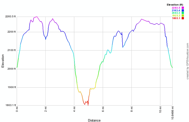 (The image at the left shows the profile of the hike. Remember that all vertical profiles are relative!)
Sam's Point: Greater Ice Caves
| Quick Look | ||||
|---|---|---|---|---|
| Difficulty | Round trip | Total climb | Internet Maps | |
| 4.9 mi. | 1576 ft. | AllTrails | ||
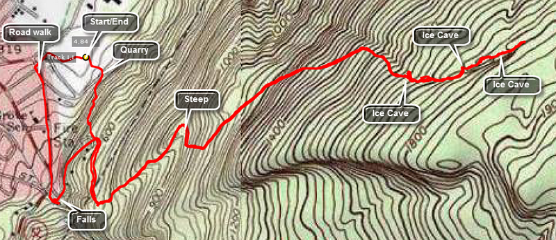 The hiking trails throughout the Sam's Point Preserve vary from open carriageway to narrow "maintained"
trails through the brush, over the bogs and around many interesting rock formations. There are
several different variations in length from the trail through the Ice Caves and to Sam's Point which
is about 4 miles to the 10.5 mile complete loop. The ecology is a pine barrens with some hardwood
sections and many boggy areas. Verkeerder Kill falls is well worth the visit as are the Ice Caves.
These "caves" are actually tectonic caves formed when part of the mountain pulled away forming
deep crevices in the rock.
The hiking trails throughout the Sam's Point Preserve vary from open carriageway to narrow "maintained"
trails through the brush, over the bogs and around many interesting rock formations. There are
several different variations in length from the trail through the Ice Caves and to Sam's Point which
is about 4 miles to the 10.5 mile complete loop. The ecology is a pine barrens with some hardwood
sections and many boggy areas. Verkeerder Kill falls is well worth the visit as are the Ice Caves.
These "caves" are actually tectonic caves formed when part of the mountain pulled away forming
deep crevices in the rock.
This hike is a bushwhack to the Greater Ice Caves which were never a commercial venture. They are much more impressive than the caves on top of the Sams Point plateau. Take Route 52 through Ellenville towards Cragsmoor. Just before the road heads up the mountain turn left on Berme Road. Just before the fire station on the right, turn right and park in the upper parking area. Walk to the kiosk and look for a path that's heads up through a quarry. After this the path is a bushwhack that follows some woods roads and then a barely discernible path to the caves. This is VERY steep in places. Many of the caves are accessible but be careful since a slip could mean a serious injury. One or more of the caves will have ice far into the summer.
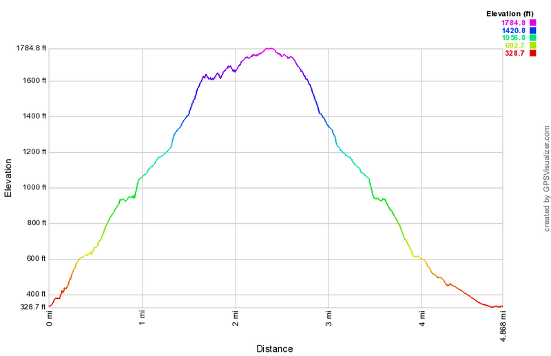 (The image at the left shows the profile of the hike. Remember that all vertical profiles are relative!)
Sam's Point: Ice Caves and Indian Rock
| Quick Look | ||||
|---|---|---|---|---|
| Difficulty | Round trip | Total climb | Internet Maps | |
| 6.4 mi. | 800 ft. | AllTrails | ||
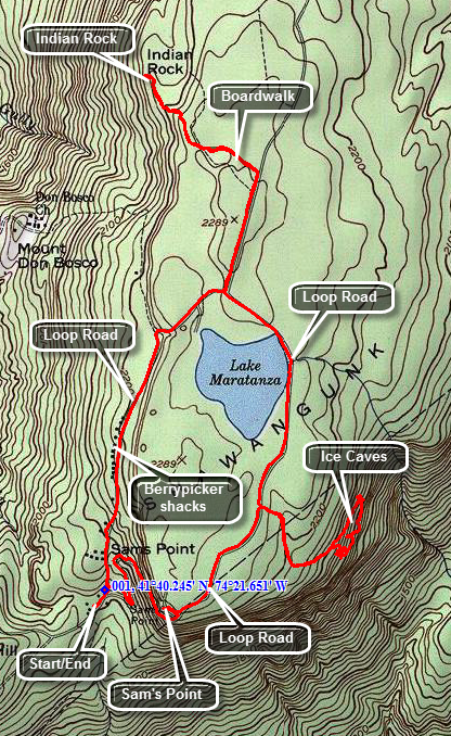 The hiking trails throughout the Sam's Point Preserve vary from open carriageway to narrow "maintained"
trails through the brush, over the bogs and around many interesting rock formations. There are
several different variations in length from the trail through the Ice Caves and to Sam's Point which
is about 4 miles to the 10.5 mile complete loop. The ecology is a pine barrens with some hardwood
sections and many boggy areas. Verkeerder Kill falls is well worth the visit as are the Ice Caves.
These "caves" are actually tectonic caves formed when part of the mountain pulled away forming
deep crevices in the rock.
The hiking trails throughout the Sam's Point Preserve vary from open carriageway to narrow "maintained"
trails through the brush, over the bogs and around many interesting rock formations. There are
several different variations in length from the trail through the Ice Caves and to Sam's Point which
is about 4 miles to the 10.5 mile complete loop. The ecology is a pine barrens with some hardwood
sections and many boggy areas. Verkeerder Kill falls is well worth the visit as are the Ice Caves.
These "caves" are actually tectonic caves formed when part of the mountain pulled away forming
deep crevices in the rock.
For this hike, park at the Conservation Center lot and pay the $7 fee for one time use or buy a yearly pass for $40. Head toward the Loop Road and bear right up the hill toward Sam's Point. Visit Sam's Point the next time you come since this hike is long enough already. After about a mile on the loop road, turn right onto Ice Caves Road and continue straight ahead on the road that goes to the ice caves entrance. This road is highly eroded so be careful as you negotiate the path. The ice caves have various wooden stairs and walkways throughout their length which can be slippery when wet. A few places require you to squeeze through narrow spaces. When you come out of the caves, spend a few minutes looking east. You will see Lake Awosting and the cliffs of Castle And Hamilton Points. All of these features are in Minnewaska State Park. Walk back up the road to the loop road and turn right.
The walk now is on the once paved and maintained Loop Road as is almost flat. You will pass by Lake Maratanza on your left which is one of the :sky Lakes". The pH is too low to allow most living things to live in the lake. The lake acts as an emergency source of water for Ellenville. Continue on around the lake until a road branches to the right. This is a carriageway that leads to High Point or the Smiley Carriageway. Walk about .4 miles and watch for a trail on the left to Indian Rock. The trail begins with a series of boardwalks. The area can be very wet which makes the boardwalks helpful but many times it is dry. It is a little more than .5 miles to Indian Rock with a loss of about 90 feet. The trail may be hard to follow as the blazes are mostly painted on the rocks. Indian Rock is a large boulder set on other rocks with a cavity below. It is possible to enhance your view by CAREFULLY climbing to the top. Either way, there is a nice view of the valley below. When you are done retrace your route back to the carriageway and back out to the Loop Road. Turn right to complete the loop back to the parking area. You will pass several transmission and microwave towers along the final 1.2 miles of the hike.
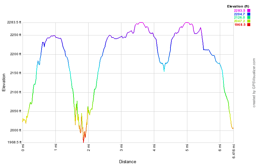 (The image at the left shows the profile of the hike. Remember that all vertical profiles are relative!)
Sam's Point: Lake Awosting Loop on Berrypicker's Path
| Quick Look | ||||
|---|---|---|---|---|
| Difficulty | Round trip | Total climb | Internet Maps | |
| 13.3 mi. | 1412 ft. | AllTrails | ||
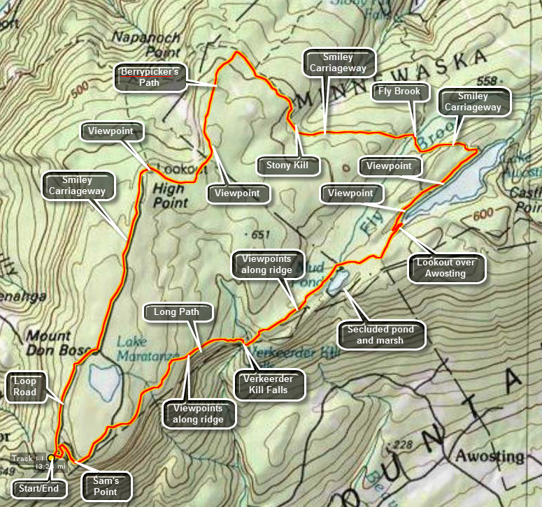 The hiking trails throughout the Sam's Point Preserve vary from open carriageway to narrow "maintained"
trails through the brush, over the bogs and around many interesting rock formations. There are
several different variations in length from the trail through the Ice Caves and to Sam's Point which
is about 4 miles to the 10.5 mile complete loop. The ecology is a pine barrens with some hardwood
sections and many boggy areas. Verkeerder Kill falls is well worth the visit as are the Ice Caves.
These "caves" are actually tectonic caves formed when part of the mountain pulled away forming
deep crevices in the rock.
The hiking trails throughout the Sam's Point Preserve vary from open carriageway to narrow "maintained"
trails through the brush, over the bogs and around many interesting rock formations. There are
several different variations in length from the trail through the Ice Caves and to Sam's Point which
is about 4 miles to the 10.5 mile complete loop. The ecology is a pine barrens with some hardwood
sections and many boggy areas. Verkeerder Kill falls is well worth the visit as are the Ice Caves.
These "caves" are actually tectonic caves formed when part of the mountain pulled away forming
deep crevices in the rock.
For this hike, park at the Conservation Center lot and pay the $7 fee for one time use or buy a yearly pass for $40. Head toward the Loop Road and bear right up the hill toward Sam's Point. Visit Sam's Point the next time you come since this hike is long enough already. After about a mile on the loop road, turn right onto Ice Caves Road and then left onto the Verkeerder Kill Falls Trail. Again, save the Ice Caves for another day when you will be hiking less than 13 miles! The Verkeerder Kill Falls Trail drops to the falls at one of the lowest points on the hike after about 1.7 miles. Along the way there are some nice views and various birds can be seen riding the air currents.
To continue on the hike CAREFULLY cross the Kill above the Falls. This can be easy or very difficult depending on the water level. Walk along the edge of the ravine to get the best look at the falls. When you have had your fill. walk back to the Long Path and continue the hike. In a short distance, the trail climbs steeply but briefly up to the escarpment. In .2 miles you will be at the trail junction where the High Point Trail turns left to go to High Point and then heads back to the parking area. Turn right here to stay on the Long Path and follow its aqua markers. The trail continues through the pine barrens environments and over rocky outcroppings. In. .7 miles a small but beautiful pond with the misleading name of Mud Pond will appear on the right. Continue passed the pond for about another mile and you will be on a rocky cliff overlooking Lake Awosting. This is a good place to stop for a moment or longer.
Continue on the Long Path until you see a path down to the road around Lake Awosting. Go down the path and turn left a the bottom. Hike clockwise around the lake for 1.2 miles. Just as the ranger cabin comes into view turn left on the Smiley Carriageway. This is not marked with any blazes and can be hard to follow the first time you are on it. In .7 miles you will cross Fly Brook which can run high at times. Immediately after the brook turn left up the hill toward Stony Kill. After 1.1 miles you will cross the Stony Kill which usually has little or no volume so close to its source. After this the carriageway becomes steeper and very rocky in places. As it flattens at the top it is not unusual to find a large amount of standing water on the path.
In .9 miles the Berrypicker's Path turns left and is marked with rock cairns and old pots and pans. This is listed as an unmaintained trail but seems to be well marked. In additional to light blue blazes, hikers have set up many rock cairns and added many fanciful stone designs. The trail lasts for 1.75 miles at which point it meets the High Point Trail on the left. The views from here are good in all directions. Walk on the High Point Trail for a short distance. You can continue to High Point and return or descend on the right directly to the Smiley Carriageway. The carriageway joins the Sam's Point Loop Road after 1.7 miles. Turn right on the loop road and walk 1.1 miles back to the Conservation Center.
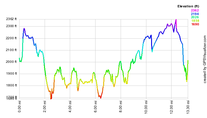 (The image at the left shows the profile of the hike. Remember that all vertical profiles are
relative!)
(The image at the left shows the profile of the hike. Remember that all vertical profiles are
relative!)
Sam's Point: Lake Awosting Loop on Smiley Carriageway
| Quick Look | ||||
|---|---|---|---|---|
| Difficulty | Round trip | Total climb | Internet Maps | |
| 13.1 mi. | 2000 ft. | AllTrails | ||
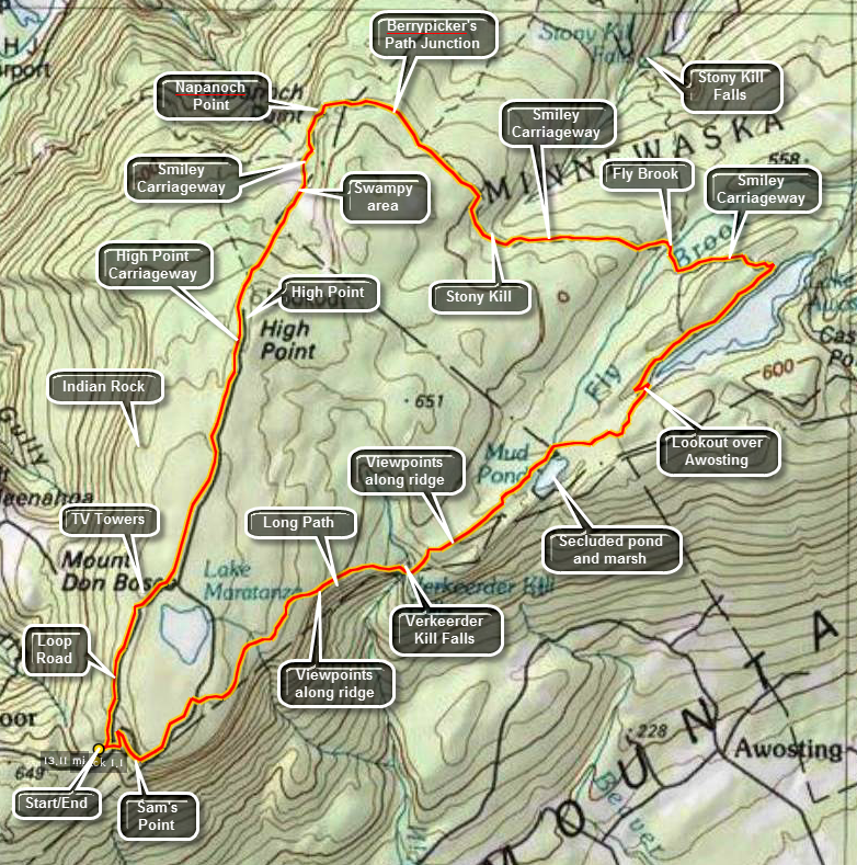 The hiking trails throughout the Sam's Point Preserve vary from open carriageway to narrow "maintained"
trails through the brush, over the bogs and around many interesting rock formations. There are
several different variations in length from the trail through the Ice Caves and to Sam's Point which
is about 4 miles to the 10.5 mile complete loop. The ecology is a pine barrens with some hardwood
sections and many boggy areas. Verkeerder Kill falls is well worth the visit as are the Ice Caves.
These "caves" are actually tectonic caves formed when part of the mountain pulled away forming
deep crevices in the rock.
The hiking trails throughout the Sam's Point Preserve vary from open carriageway to narrow "maintained"
trails through the brush, over the bogs and around many interesting rock formations. There are
several different variations in length from the trail through the Ice Caves and to Sam's Point which
is about 4 miles to the 10.5 mile complete loop. The ecology is a pine barrens with some hardwood
sections and many boggy areas. Verkeerder Kill falls is well worth the visit as are the Ice Caves.
These "caves" are actually tectonic caves formed when part of the mountain pulled away forming
deep crevices in the rock.
Park in the lot at the Visitor's Center at Sam's Point. Be sure you pay the parking fee or buy a pass that is good for a year. As you walk toward the trails, you may bear to the left or right. Bear to the left and begin to hike up the loop road on a gentle grade. Watch on your left for some of the shacks used by blueberry pickers in years gone by. These shacks are all but gone but hark back to an era when berry picking was a commercial venture. At about .3 miles the South Gully Trail branches left off the loop road. This trail leads down to Route 52 and is a hike all by itself. There are several waterfalls and cascades along the trail as it parallels a stream. Continue to walk along the loop road. At about 1.0 mile there will be a short side trail that goes to the shore of Lake Maratanza. Depending on the level of the lake, this may or may not prove interesting. At this point you will start to see TV and other communications towers on your left. The High Point Carriageway bears to the left off the loop road at 1.2 miles. At about 1.5 miles a trail to the left leads to Indian Rock. Although this glacial erratic is interesting and has a nice view, save it for another, shorter hike. Continue north on the carriageway to 2.75 miles where there is a junction with the High Point Trail and the Smiley Carriageway. Continue straight ahead on the carriageway but be aware that it is not well-marked in places and can have some very wet spots along the way, The path descends to about 3.85 miles where it begins to rise some. At 4.15 miles informal pathways lead off to the left to Napanoch Point. Come back again to visit this area. After this the path turns from north to east. At 4.5 miles the Berrypicker's Path branches off to the right after which the carriageway rises and falls several times until it reaches Fly Brook at 6.6 miles. A trail to the upper part of Stony Kill Falls turns to the left while you should bear to the right and cross Fly Brook. Follow the carriageway which becomes more well-defined bearing left at a T. This will lead to the shores of Lake Awosting near the ranger's cabin at 6.6 miles. Turn right on the Lake Awosting Carriageway to continue anticlockwise around the lake. Near the inlet end there are several nice viewpoints. Just after rounding the end of the lake, find a path to the right at about 8.55 miles which leads to the Long Path. Turn right on the aqua blazed Long Path to head southwest toward Verkeerder Kill Falls. At 9.5 miles you will pass by Mud Pond or Haseco Lake which is the source of Fly Brook. Some wooden walkways help to cross a few wet areas. Part of the trail here passes through some laurel tunnels before ascending to some rocky outcrops which overlook the lake. The trail continues along these outcrops until it descends to the falls at 10.5 miles. Be careful crossing the stream above the falls. You will now hike 1.5 miles and gain 450 feet to the road that goes the ice caves. Along the way the trail is rocky and can be wet. There are some nice views of the valley below and some of Lake Awosting and Castle Point if you look back over your shoulder. Turn right on the road and walk up to the Loop Road. Turn left and walk about 1 mile back to where you are parked.
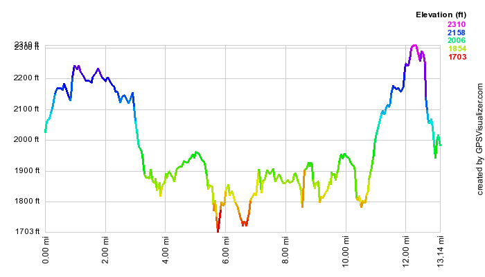 (The image at the left shows the profile of the hike. Remember that all vertical profiles are
relative!)
(The image at the left shows the profile of the hike. Remember that all vertical profiles are
relative!)
Sam's Point: Lake Awosting via Long Path
| Quick Look | ||||
|---|---|---|---|---|
| Difficulty | Round trip | Total climb | Internet Maps | |
| 9.1 mi. | 1290 ft. | AllTrails | ||
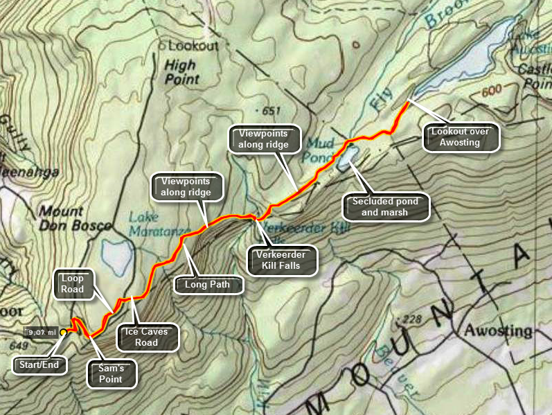 The hiking trails throughout the Sam's Point Preserve vary from open carriageway to narrow "maintained"
trails through the brush, over the bogs and around many interesting rock formations. There are
several different variations in length from the trail through the Ice Caves and to Sam's Point which
is about 4 miles to the 10.5 mile complete loop. The ecology is a pine barrens with some hardwood
sections and many boggy areas. Verkeerder Kill falls is well worth the visit as are the Ice Caves.
These "caves" are actually tectonic caves formed when part of the mountain pulled away forming
deep crevices in the rock.
The hiking trails throughout the Sam's Point Preserve vary from open carriageway to narrow "maintained"
trails through the brush, over the bogs and around many interesting rock formations. There are
several different variations in length from the trail through the Ice Caves and to Sam's Point which
is about 4 miles to the 10.5 mile complete loop. The ecology is a pine barrens with some hardwood
sections and many boggy areas. Verkeerder Kill falls is well worth the visit as are the Ice Caves.
These "caves" are actually tectonic caves formed when part of the mountain pulled away forming
deep crevices in the rock.
Park at the Visitors Center at the Sam's Point Preserve and start out on the Loop Road to the right. Hike up the Loop Road passing the spur trail to Sam's Point on the left. This hike is already long but you may visit the lookout if you wish. Turn right on the road that goes down to the ice caves. Turn then a left onto the Verkeerder Kill Falls Trail which has the aqua blazes of the Long Path. This trail has some beautiful views out over the flat valley on your right. Straight ahead on the trail you will see the cliffs of Castle Point and Hamilton Point at Minnewaska State Park and the blue waters of Lake Awosting. The trail drops 500 feet in about 1.75 miles to the lowest point on the hike at Verkeerder Kill Falls at 2.6 miles into the hike. There are lookouts on both sides of the falls. The falls are more interesting when there has been some rainfall but this makes crossing the stream above the falls more dangerous! After observing the falls from the far side, continue on the trail as it rises to a trail junction over the next .3 miles. Turn right to stay on the Long Path and head to Lake Awosting. Older maps show this part of the trail as "Closed" or "Do not enter" but the land has been purchased by the Preserve and is now open to the public. The trail at first passes over mostly open rock and hikers have constructed many small cairns along the way. After about 1.1 miles Mud Pond or Lake Haseco came into view at 3.5 miles with a nice viewpoint overlooking the water. As you continue on the trail, a path to the right goes down to the shore of the pond. Back on the trail there is a wooden walkway over some muddy areas and Fly Brook. After another mile at about 5 miles you will be at a lookout over Lake Awosting at the southwestern end of the lake. Turn around and follow the Long Path back to Verkeerder Kill Falls at 6.5 miles. Cross over the stream and begin a long 1.75 mile climb back to the road above the ice caves. The trail gains elevation and passes over a lot of uneven and large rocks which you may remember from the hike down to the falls. Turn right at the road and then left at the loop road to get back down to the Visitors Center.
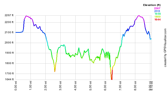 (The image at the left shows the profile of the hike. Remember that all vertical profiles are
relative!)
(The image at the left shows the profile of the hike. Remember that all vertical profiles are
relative!)
Sam's Point: Main Loop
| Quick Look | ||||
|---|---|---|---|---|
| Difficulty | Round trip | Total climb | Internet Maps | |
| 8.8 mi. | 1220 ft. | AllTrails | ||
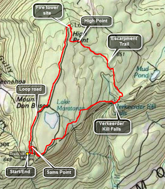 The hiking trails throughout the Sam's Point Preserve vary from open carriageway to narrow "maintained"
trails through the brush, over the bogs and around many interesting rock formations. There are
several different variations in length from the trail through the Ice Caves and to Sam's Point which
is about 4 miles to the 10.5 mile complete loop. The ecology is a pine barrens with some hardwood
sections and many boggy areas. Verkeerder Kill falls is well worth the visit as are the Ice Caves.
These "caves" are actually tectonic caves formed when part of the mountain pulled away forming
deep crevices in the rock.
The hiking trails throughout the Sam's Point Preserve vary from open carriageway to narrow "maintained"
trails through the brush, over the bogs and around many interesting rock formations. There are
several different variations in length from the trail through the Ice Caves and to Sam's Point which
is about 4 miles to the 10.5 mile complete loop. The ecology is a pine barrens with some hardwood
sections and many boggy areas. Verkeerder Kill falls is well worth the visit as are the Ice Caves.
These "caves" are actually tectonic caves formed when part of the mountain pulled away forming
deep crevices in the rock.
Park in the lot at the Visitor's Center at Sam's Point. Be sure you pay the parking fee or buy a pass that is good for a year. As you walk toward the trails, you may bear to the left or right. Bear to the right on the Loop Road toward Sam's Point. This hike leaves out many of the "attractions" in favor of a slightly shorter(?) hike. As you ascend the road there will be good views from open rocks ledges on the right. Pass by the side path to Sam's Point and continue on to the road. Turn right on the road that goes down to the ice caves. Turn then a left onto the Verkeerder Kill Falls Trail which has the aqua blazes of the Long Path. This trail has some beautiful views out over the flat valley on your right. Straight ahead on the trail you will see the cliffs of Castle Point and Hamilton Point at Minnewaska State Park and the blue waters of Lake Awosting. The trail drops 500 feet in about 1.75 miles to the lowest point on the hike at Verkeerder Kill Falls at 2.9 miles into the hike. There are lookouts on both sides of the falls. The falls are more interesting when there has been some rainfall but this makes crossing the stream above the falls more dangerous! After observing the falls from the far side, continue on the trail as it rises to a trail junction over the next .3 miles. Bear left on the red High Point Trail. For the next 2 miles this trail follows the edge of the escarpment on its way to High Point. The trail has some fantastic views over the valley and you can always take a look back at where you have been and ahead to where you are going. As the trail approaches High Point it passes through some brush. The trail here may be wet depending on the recent rainfall and the brush may be thick. The red blazes are painted on the rocks and may be hard to see. At about 5.4 miles, you will climb a steep spot and be on High Point which is marked by a USGS benchmark. Continue on the trail for another .3 miles to an area where there was once a fire observation tower. You can still see the iron moorings of the tower embedded in the rock. Walk down the trail to where it ends on the High Point Carriageway. Turn left to start back to the Visitors Center. The carriageway gains some elevation until and 7.25 miles the spur trail to Indian Rock appears on the right. Continue on the carriageway to the Loop Road at 7.6 miles. Turn right on the road in the area where there are several communications towers. The road now continuously descends over the next 1.2 miles until you are back in the parking lot. Along the way you may see what remains of the sheds used by blueberry pickers back in the day when that was a commercial enterprise. At 8.5 miles the South Gully Trail will be on the right. This trail is a nice hike on its own and is part of the Long Path. When the South Gully Trail gets to Route 52, It connects to the Shawangunk Ridge Trail.
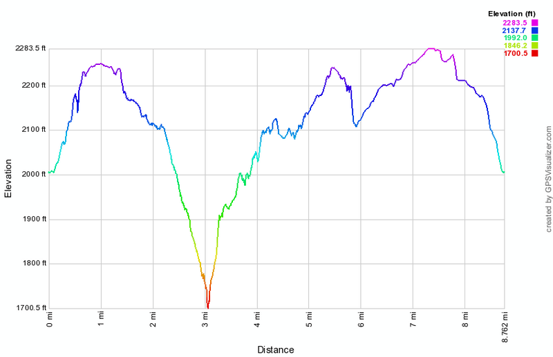 (The image at the left shows the profile of the hike. Remember that all vertical profiles are relative!)
Sam's Point: Napanoch Point and Berrypicker's Trail
| Quick Look | ||||
|---|---|---|---|---|
| Difficulty | Round trip | Total climb | Internet Maps | |
| 10.9 mi. | 1137 ft. | AllTrails | ||
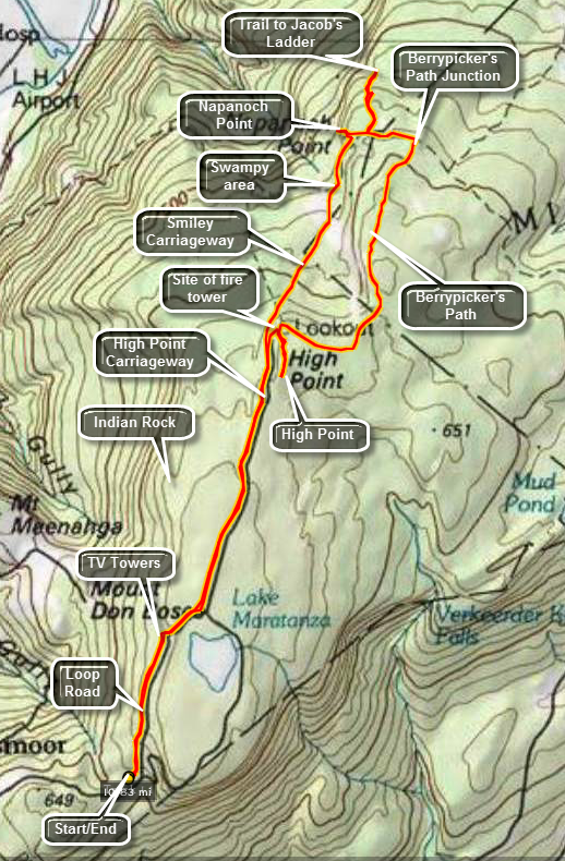 The hiking trails throughout the Sam's Point Preserve vary from open carriageway to narrow "maintained"
trails through the brush, over the bogs and around many interesting rock formations. There are
several different variations in length from the trail through the Ice Caves and to Sam's Point which
is about 4 miles to the 10.5 mile complete loop. The ecology is a pine barrens with some hardwood
sections and many boggy areas. Verkeerder Kill falls is well worth the visit as are the Ice Caves.
These "caves" are actually tectonic caves formed when part of the mountain pulled away forming
deep crevices in the rock.
The hiking trails throughout the Sam's Point Preserve vary from open carriageway to narrow "maintained"
trails through the brush, over the bogs and around many interesting rock formations. There are
several different variations in length from the trail through the Ice Caves and to Sam's Point which
is about 4 miles to the 10.5 mile complete loop. The ecology is a pine barrens with some hardwood
sections and many boggy areas. Verkeerder Kill falls is well worth the visit as are the Ice Caves.
These "caves" are actually tectonic caves formed when part of the mountain pulled away forming
deep crevices in the rock.
Park in the lot at the Visitor's Center at Sam's Point. Be sure you pay the parking fee or buy a pass that is good for a year. As you walk toward the trails, you may bear to the left or right. Bear to the left and begin to hike up the loop road on a gentle grade. Watch on your left for some of the shacks used by blueberry pickers in years gone by. These shacks are all but gone but hark back to an era when berry picking was a commercial venture. At about .3 miles the South Gully Trail branches left off the loop road. This trail leads down to Route 52 and is a hike all by itself. There are several waterfalls and cascades along the trail as it parallels a stream. Continue to walk along the loop road. At about 1.0 mile there will be a short side trail that goes to the shore of Lake Maratanza. Depending on the level of the lake, this may or may not prove interesting. At this point you will start to see TV and other communications towers on your left. The High Point Carriageway bears to the left off the loop road at 1.2 miles. At about 1.5 miles a trail to the left leads to Indian Rock. Although this glacial erratic is interesting and has a nice view, save it for another, shorter hike. Continue north on the carriageway to 2.75 miles where there is a junction with the High Point Trail and the Smiley Carriageway. Continue straight ahead on the carriageway but be aware that it is not well-marked in places and can have some very wet spots along the way, The path descends to about 3.85 miles where it begins to rise some. At 4.15 miles informal pathways lead off to the left to Napanoch Point. Turn left here for a short bushwhack out to this viewpoint. You may also find some areas where there have been campfires. Return to the main path and at 4.4 miles another path heads left or north toward Jacob's Ladder. You may turn here and walk about .4 miles since there are some views on this descent. Turn around and walk back to the main carriageway and turn left. At 5.6 miles the Berrypicker's Path branches off to the right. Make the turn and be prepared for a 1.8 mile uphill walk across open rock and through scrub pines. Along the way hikers have created cairns and other designs with stones. At the end of this trail you will be in the area where there was once a fire tower. Before descending back to the High Point Carriageway, follow the High Point Trail .3 miles to High Point. A USGS marker is embedded here in the stone. Retrace your path and descend to the High Point Carriageway and turn left to start back to the Visitors Center. At 9.3 miles the spur trail to Indian Rock will be on your right. When you reach the Loop Road at 9.7 miles turn right. The communications towers will be on your right. At 10.6 miles you will pass by the South Gully Trail and the berrypicker's shacks. From here it is a short walk to your car.
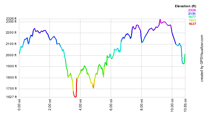 (The image at the left shows the profile of the hike. Remember that all vertical profiles are
relative!)
(The image at the left shows the profile of the hike. Remember that all vertical profiles are
relative!)
Sam's Point: South Gully Trail and Loop
| Quick Look | ||||
|---|---|---|---|---|
| Difficulty | Round trip | Total climb | Internet Maps | |
| 8.2 mi. | 1977 ft. | AllTrails | ||
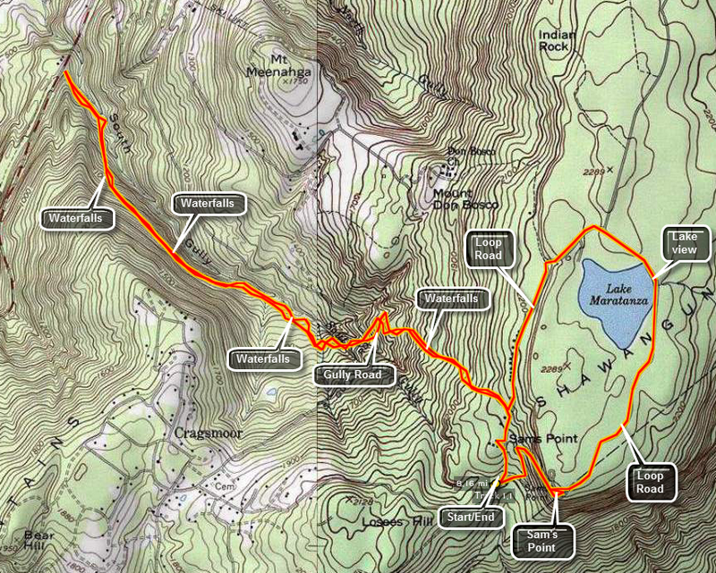
Take New York State Route 52 east from Ellenville. The road will begin to climb the Shawangunk Ridge as soon as you leave town. The road winds up along the ridge and there are several pulloffs on the way up. On a clear day park at one of these areas and enjoy the view of the valley and the Catskills beyond. Just as the road leaves town look on the left as you pass over a bridge. There is a beautiful waterfall with small rapids below it. Watch for a sign on the right that says Cragsmoor and turn to the left at this road. Follow Cragsmoor Road to the hamlet of Cragsmoor and bear left near the library and post office. Watch for the turn to the right onto Sam's Point Road. Follow the road to the Conservation Center parking area. Be sure to put your pass in the window or pay the fee at the Center.
Walk toward the beginning of the loop road and bear to the left. Walk up the hill and pass the first set of Berrypicker shacks. Watch for the aqua markers of the long path. Three of these markers on the left side of the road mark the start of the South Gully Trail which will be part of the Long Path. Turn left onto the trail. The trail passes some of the shacks and then starts a LONG descent toward Route 52. In about .7 miles you will cross Gully Road. Along the way there are several small but pretty cascades but nothing compared to what awaits AFTER crossing the road. Turn left on Gully Road and walk just slightly up the hill and across the road. Pick up the trail again.
For the next 1.5 miles you will be treated to the roar of the stream that passes through the gully. The volume will depend on the season and the amount of rain. There are MANY opportunities to walk off the trail and down to the stream to take pictures, wade on a hot day or just enjoy the views. Many of the cascades show parallel layers of sedimentary rocks of varying hardness. As the water falls over the rocks they erode and fall to the base of the cascade. The last half mile of the trail is slightly uphill and then flat out to Route 52. The return hike is slightly more strenuous as you retrace your steps UP 1400 feet back to the Sam's Point Loop Road. At the road you can continue on around the lake as shown in the map here. You can also extend the hike with any of the many "side trips" that are available or go directly back to the Conservation Center.
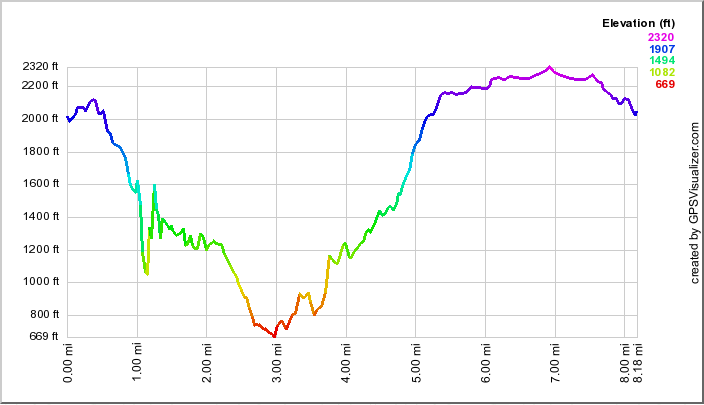 (The image at the left shows the profile of the hike. Remember that all vertical profiles are
relative!)
(The image at the left shows the profile of the hike. Remember that all vertical profiles are
relative!)
Sam's Point: South Gully Trail Only
| Quick Look | ||||
|---|---|---|---|---|
| Difficulty | Round trip | Total climb | Internet Maps | |
| 6.1 mi. | 2143 ft. | AllTrails | ||
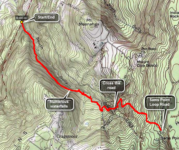
Take New York State Route 52 east from Ellenville. The road will begin to climb the Shawangunk Ridge as soon as you leave town. The road winds up along the ridge and there are several pulloffs on the way up. On a clear day park at one of these areas and enjoy the view of the valley and the Catskills beyond. Just as the road leaves town look on the left as you pass over a bridge. There is a beautiful waterfall with small rapids below it. About 1.1 miles from this waterfall Route 52 will cross South Gully on a bridge. At the end of the bridge is a wide shoulder on the left side of the road. Turn around and park on the wide shoulder by the guardrail. This is where the trail begins. The first part of the trail drops a little from the road to the stream that forms South Gully. At the bottom of the descent, you may walk over to the stream and take some pictures before getting back on the trail. There are MANY small waterfalls and rapids along the stream! In some places the trail almost disappears and you must sidehill. Slippery leaves and pine needles makes this section of trail interesting. You may want to walk down to the stream at several points along the way to take pictures of some of the small waterfalls and rapids. At about 2.1 miles you will come to South Gully Road. Walk out to the road and turn left. Walk across the road and downhill for a short distance before picking up the trail on the other side.
From South Gully Road the trail becomes a little steeper before leveling off near the top of the plateau. Over the first 2 miles you will gain just over 300 feet. In the next mile to the junction with the loop road, the gain is almost 700 feet. At around 3 miles you will reach the Loop Road at Sam's Point. Turn around and retrace your route back to the car at 9.2 miles.
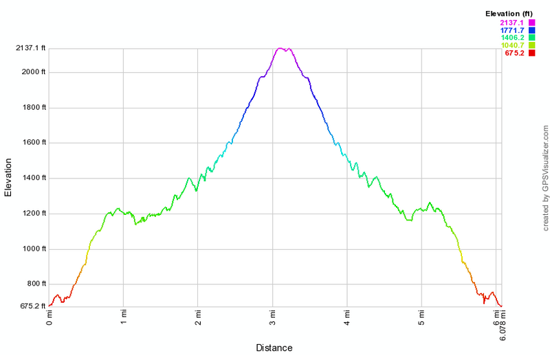 (The image at the left shows the profile of the hike. Remember that all vertical profiles are relative!)
Sam's Point: South Gully Trail and Lake Loop
| Quick Look | ||||
|---|---|---|---|---|
| Difficulty | Round trip | Total climb | Internet Maps | |
| 9.2 mi. | 2470 ft. | AllTrails | ||
_map.png)
Take New York State Route 52 east from Ellenville. The road will begin to climb the Shawangunk Ridge as soon as you leave town. The road winds up along the ridge and there are several pulloffs on the way up. On a clear day park at one of these areas and enjoy the view of the valley and the Catskills beyond. Just as the road leaves town look on the left as you pass over a bridge. There is a beautiful waterfall with small rapids below it. About 1.1 miles from this waterfall Route 52 will cross South Gully on a bridge. At the end of the bridge is a wide shoulder on the left side of the road. Turn around and park on the wide shoulder by the guardrail. This is where the trail begins. The first part of the trail drops a little from the road to the stream that forms South Gully. At the bottom of the descent, you may walk over to the stream and take some pictures before getting back on the trail. There are MANY small waterfalls and rapids along the stream! In some places the trail almost disappears and you must sidehill. Slippery leaves and pine needles makes this section of trail interesting. You may want to walk down to the stream at several points along the way to take pictures of some of the small waterfalls and rapids. At about 2.1 miles you will come to South Gully Road. Walk out to the road and turn left. Walk across the road and downhill for a short distance before picking up the trail on the other side.
From South Gully Road the trail becomes a little steeper before leveling off near the top of the plateau. Over the first 2 miles you will gain just over 300 feet. In the next mile to the junction with the loop road, the gain is almost 700 feet. At around 3 miles you will reach the Loop Road at Sam's Point. Turn left and start to walk around the Lake Maratanza. Hiking on the road is easy compared to the trail. The road surface is flat and it is almost level with only a slight elevation gain. A series of cliffs will appear on your right. When a path appears on the right, you may want to take the path as there are some very nice views from the top of these cliffs. Go back to the path and continue on around the lake in a clockwise direction. On the far side of the lake the road runs right next to the water and you can get some unobstructed views of the water. Continue on passed the road on the left that goes down to the ice caves. Turn right at the next path and walk up to the overlook at Sam's Point. Go back to the road and turn right to walk down to an area near the Visitor's Center where you will turn right to get back up to the South Gully Trail at 6.3 miles. Turn left onto the trail and retrace your route back to the car at 9.2 miles.
_gra.png) (The image at the left shows the profile of the hike. Remember that all vertical profiles are relative!)
(The image at the left shows the profile of the hike. Remember that all vertical profiles are relative!)
Sam's Point: South Gully Trail Road Loop
| Quick Look | ||||
|---|---|---|---|---|
| Difficulty | Round trip | Total climb | Internet Maps | |
| 9.2 mi. | 2470 ft. | AllTrails | ||
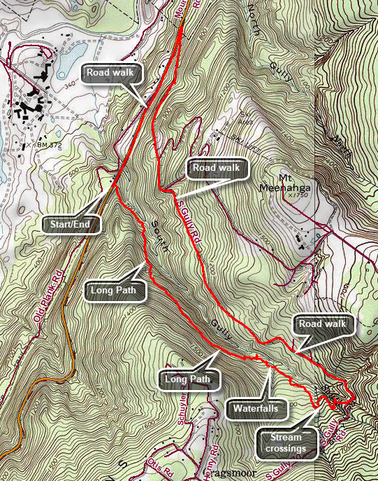
Take New York State Route 52 east from Ellenville. The road will begin to climb the Shawangunk Ridge as soon as you leave town. The road winds up along the ridge and there are several pulloffs on the way up. On a clear day park at one of these areas and enjoy the view of the valley and the Catskills beyond. Just as the road leaves town look on the left as you pass over a bridge. There is a beautiful waterfall with small rapids below it. About 1.1 miles from this waterfall Route 52 will cross South Gully on a bridge. At the end of the bridge is a wide shoulder on the left side of the road. Turn around and park on the wide shoulder by the guardrail. This is where the trail begins. The first part of the trail drops a little from the road to the stream that forms South Gully. At the bottom of the descent, you may walk over to the stream and take some pictures before getting back on the trail. There are MANY small waterfalls and rapids along the stream! In some places the trail almost disappears and you must sidehill. Slippery leaves and pine needles makes this section of trail interesting. You may want to walk down to the stream at several points along the way to take pictures of some of the small waterfalls and rapids. At about 2.1 miles you will come to South Gully Road. Walk out to the road and turn left to walk down South Gully Road for 2.4 miles to Route 52. Turn left on Route 52 and walk .9 miles back to the car.
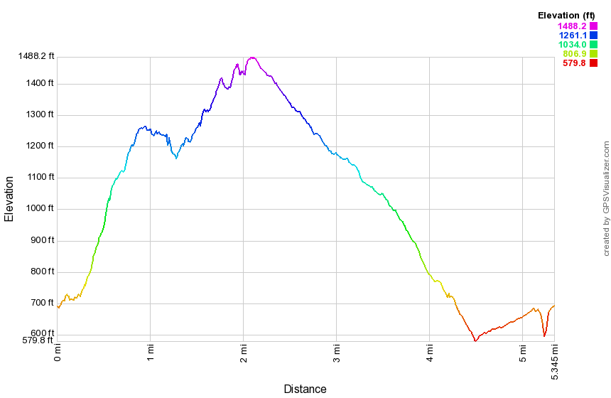 (The image at the left shows the profile of the hike. Remember that all vertical profiles are relative!)
Sam's Point: Verkeerder Kill Falls and Lake Loop
| Quick Look | ||||
|---|---|---|---|---|
| Difficulty | Round trip | Total climb | Internet Maps | |
| 6.8 mi. | 885 ft. | AllTrails | ||
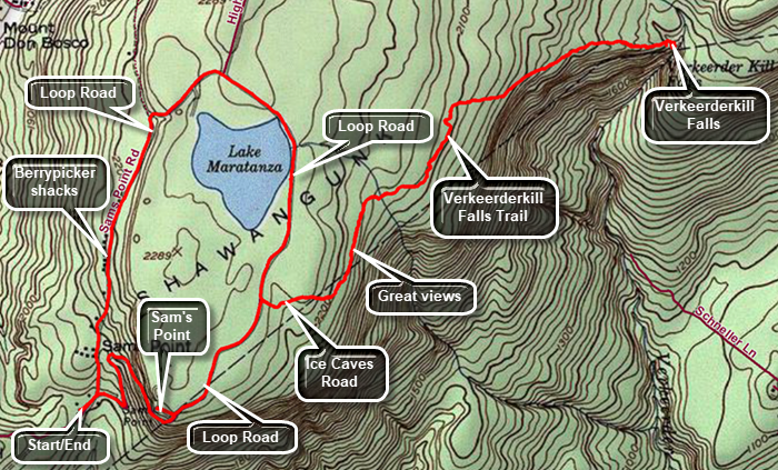 The hiking trails throughout the Sam's Point Preserve vary from open carriageway to narrow "maintained" trails through the brush, over the bogs and around many interesting rock formations. There are several different variations in length from the trail through the Ice Caves and to Sam's Point which is about 4 miles to the 10.5 mile complete loop. The ecology is a pine barrens with some hardwood sections and many boggy areas. Verkeerder Kill falls is well worth the visit as are the Ice Caves. These "caves" are actually tectonic caves formed when part of the mountain pulled away forming deep crevices in the rock.
Park in the lot at the Visitor's Center at Sam's Point. Be sure you pay the parking fee or buy a pass that is good for a year. As you walk toward the trails, you may bear to the left or right. Bear to the right on the Loop Road toward Sam's Point. This hike leaves out many of the "attractions" in favor of a slightly shorter hike. As you ascend the road there will be good views from open rocks ledges on the right. At the top of the climb as the road levels there will be a side path to Sam's Point. Turn left here and walk out to this spectacular viewpoint. When you are done retrace your steps and continue on to the road. Turn right on the road that goes down to the Ice Caves. Turn at the first left onto the Verkeerder Kill Falls Trail which has the aqua blazes of the Long Path. This trail has some beautiful views out over the flat valley on your right. Straight ahead on the trail you will see the cliffs of Castle Point and Hamilton Point at Minnewaska State Park and the blue waters of Lake Awosting. The trail drops 500 feet in about 1.75 miles to the lowest point on the hike at Verkeerder Kill Falls at 3.1 miles into the hike. There are lookouts on both sides of the falls. Walk toward the falls on the near side and find a ledge that acts as a viewpoint. The falls are more interesting when there has been some rainfall but this makes crossing the stream above the falls more dangerous! After observing the falls from the near side, continue on the trail as it crosses the creek above the falls. BE CAREFUL as slipping here in high water could have disastrous results! On the far side walk along the chasm to the lookouts. These viewpoints give a different view of the falls and the valley beyond. There is often a rainbow from this side. When you are done retrace your route to the road that leads down to the Ice Caves. Turn right on the loop road and walk passed the east side of Lake Maratanza. Continue on the loop road as it rounds the lake. Pass by the carriage road that leads toward High Point. As the loop road continues around the lake, you will see communications towers on the west side of the road. Further along you will see the remains of berrypickers shacks that are now the subject of an archaeological study. As you descend on the loop road, the South Gully trail will be on the right. The trail paralleled South Gully and crosses Route 52. This is the route of the Long Path which continues across Route 52 to pick up the Shawangunk Ridge Trail that heads toward Wurtsboro. You will pass one ore shack on the right and then almost immediately arrive back at the Visitor's Center.
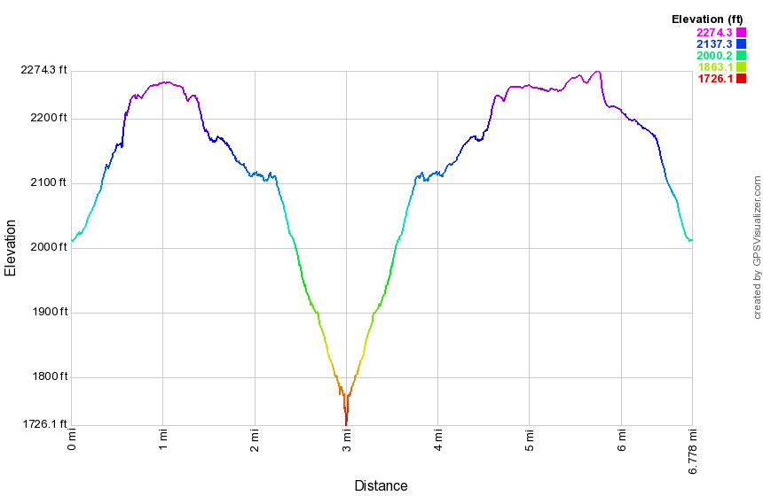 (The image shows the profile of the hike. Remember that all vertical profiles are relative!)
Sam's Point: Verkeerder Kill Falls (Out and Back))
| Quick Look | ||||
|---|---|---|---|---|
| Difficulty | Round trip | Total climb | Internet Maps | |
| 6.0 mi. | 850 ft. | AllTrails | ||
_map.png) The hiking trails throughout the Sam's Point Preserve vary from open carriageway to narrow "maintained"
trails through the brush, over the bogs and around many interesting rock formations. There are
several different variations in length from the trail through the Ice Caves and to Sam's Point which
is about 4 miles to the 10.5 mile complete loop. The ecology is a pine barrens with some hardwood
sections and many boggy areas. Verkeerder Kill falls is well worth the visit as are the Ice Caves.
These "caves" are actually tectonic caves formed when part of the mountain pulled away forming
deep crevices in the rock.
The hiking trails throughout the Sam's Point Preserve vary from open carriageway to narrow "maintained"
trails through the brush, over the bogs and around many interesting rock formations. There are
several different variations in length from the trail through the Ice Caves and to Sam's Point which
is about 4 miles to the 10.5 mile complete loop. The ecology is a pine barrens with some hardwood
sections and many boggy areas. Verkeerder Kill falls is well worth the visit as are the Ice Caves.
These "caves" are actually tectonic caves formed when part of the mountain pulled away forming
deep crevices in the rock.
Park in the lot at the Visitor's Center at Sam's Point. Be sure you pay the parking fee or buy a pass that is good for a year. As you walk toward the trails, you may bear to the left or right. Bear to the right on the Loop Road toward Sam's Point. This hike leaves out many of the "attractions" in favor of a slightly shorter(?) hike. As you ascend the road there will be good views from open rocks ledges on the right. At the top of the climb as the road levels there will be a side path to Sam's Point. Turn left here and walk out to this spectacular viewpoint. When you are done retrace your steps and continue on to the road. Turn right on the road that goes down to the ice caves. Turn at the first left onto the Verkeerder Kill Falls Trail which has the aqua blazes of the Long Path. This trail has some beautiful views out over the flat valley on your right. Straight ahead on the trail you will see the cliffs of Castle Point and Hamilton Point at Minnewaska State Park and the blue waters of Lake Awosting. The trail drops 500 feet in about 1.75 miles to the lowest point on the hike at Verkeerder Kill Falls at 3.1 miles into the hike. There are lookouts on both sides of the falls. Walk toward the falls on the near side and find a ledge that acts as a viewpoint. The falls are more interesting when there has been some rainfall but this makes crossing the stream above the falls more dangerous! After observing the falls from the near side, continue on the trail as it crosses the creek above the falls. BE CAREFUL as slipping here in high water could have disastrous results! On the far side walk along the chasm to the lookouts. These viewpoints give a different view of the falls and the valley beyond. There is often a rainbow from this side. When you are done retrace your route. You may skip Sam's Point this time or visit it again especially if the light or sky has changed.
_gra.png) (The image at the left shows the profile of the hike. Remember that all vertical profiles are relative!)
(The image at the left shows the profile of the hike. Remember that all vertical profiles are relative!)
Shawangunk Ridge Trail: Basha Kill Southern Loop
| Quick Look | ||||
|---|---|---|---|---|
| Difficulty | Round trip | Total climb | Internet Maps | |
| 10.4 mi. | 520 ft. | AllTrails | ||
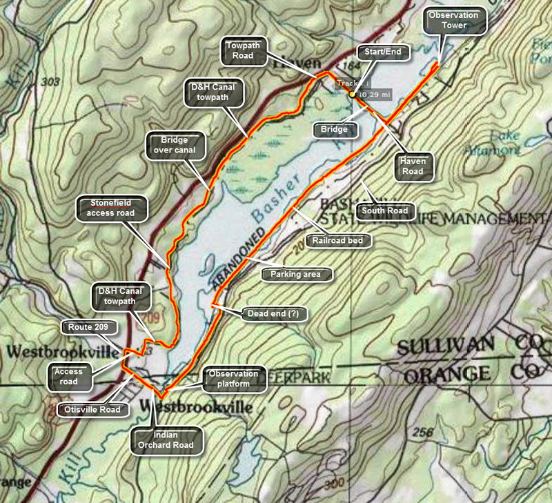 The Basha Kill is a 2400 acre wetland and wildlife preserve in the southern part of Sullivan County. Among other things it is home to at least 50 species of birds and especially bald eagles. The remains of the Port Jervis to Kingston branch of the O&W forms a rail trail on the southeastern shore. On the northwestern shore is the D&H Canal and the towpath. The two can be combined for a loop using Haven Road to cross the marsh on the northern end and Otisville Road to swing around the southern end.
Take Route 17/I 86 to exit 113 and head south on Route 209. After about 1.7 miles Haven Road appears on the left. Turn left here and drive to the parking area on the left to park. Start your hike by walking east on Haven Road through the marsh toward the rail trail on the eastern shore. Turned left or north on the rail trail. The trail here is relatively firm even when it has been raining. After about a mile watch for a trail to an observation tower and turn left on this unmarked trail. Within .1 miles you will be at the tower which is more of an observation platform. There are nice views over the marsh to the north and west. At Haven Road cross to the other side and to follow the rail trail south. The trail can be VERY wet in places especially after it rains so you may have to cross from one side to the other or use the banks to make it through this area. The banks are covered in barberry and some other thorny brush so making progress can be slow and painful. The rail trail dries out after this but still may have a few muddy spots along the way. There are views of the marsh all along the way. The trail is extremely straight which is not surprising given that it is the old railroad bed. At 3.7 miles there is one of the larger parking areas just off South Road and near the Basha Kill Winery. The water is more open in this area and people like to canoe or kayak from here. When you leave the parking area, continue on the trail which is often wet and muddy. In about .4 miles the Long Path markings appear to head to the right off the rail trail but this may be a dead end. Continue to head south on the rail trail and watch for a sign that says "Long Path". At about 4.3 miles the trail again may became wet and muddy. Turn left off the trail and walk out to the road. AVOID private property postings as there are a few in the area. Once on the road, continue south and at 4.5 miles the road will cross a small stream. Look to the left and see a beautiful waterfall. The posting in the area is unclear so read carefully before proceeding! Walk to the base of the falls and get a view of the water flowing down over a wall of rock. Walk back out to the road to continue. Walking on the road goes quickly and in about another mile at 5.5 miles into the hike there is a small parking area on the right with an observation deck. The deck gives a nice view of a stream flowing out of the Basha Kill. Turn right out of the parking area and walk to the intersection. Turn right on Otisville Road which runs out to Route 209. The D&H Canal towpath should intersect the road just before Route 209. If you cannot find the towpath, walk out to Route 209 and turn right on the road. Walk .2 miles on the road, to a sign for the Basha Kill and turn right down this dirt road. As you approached a flat area a path turns left across a field and into the trees. As you enter the trees and walk up a small incline turn right. This is the towpath. The canal and the towpath have an interesting history and I am sorry to say I don't know enough about it. The canal ran to the left or west of the towpath and in many places the canal is still very obvious. There are still stone walls on either side of the canal and even the trees that now grow in it cannot hide it. Head north and then east to get around a hill before heading north for most of the rest of the trip. The canal is now dry in most places but in some areas there is water which hints at the original purpose. In a few places you will see bridges of rock built across the canal. After the canal was no longer in use, these bridges were built across it to reach the towpath and the Basha Kill. At 7.5 miles a dirt road runs down to the Stonefield parking area and this continuous for about .35 miles. Continue on the towpath when the road turns into a parking area and at 8.25 miles there will be a bridge that was built over the original canal. The span of the bridge no longer exists but the stonework that made up the abutments is still there. Also present are the stone walls that lined the lane that leads up to the bridge. A little further on the trail crosses a chasm on a wood bridge. Just to the left is another stone bridge that crossed the canal. At 10.1 miles there is a gate which leads out onto Towpath Road. This short road soon intersects Haven Road. Turn right and walk .3 miles back to the car.
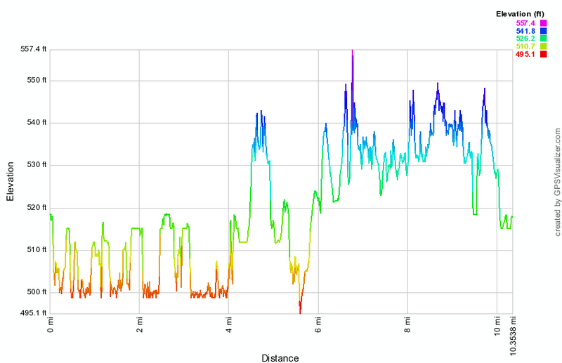 (The image at the left shows the profile of the hike. Remember that all vertical profiles are relative!)
Shawangunk Ridge Trail: Basha Kill to Guymard Turnpike
| Quick Look | ||||
|---|---|---|---|---|
| Difficulty | Round trip | Total climb | Internet Maps | |
| 12.0 mi. | 1376 ft. | AllTrails | ||
 Take the Quickway (Route 17/I86) to the exit for Route 209 in Wurtsboro and head south toward Port Jervis. After about 6 miles and turn left on Route 61 toward Otisville. Just before the bridge over the Basha Kill park in a small lot on the right side of the road. Start your hike by heading southeast on Route 61 and crossing over the bridge across the Basha Kill. The Long Path and Shawangunk Ridge Trails are co-aligned here and you should pick them up at the corner of Indian Orchard Road. Follow the markings southeast on Route 61 for about .25 miles to the point where the trail enters the forest on the left side of the road. The bank is very steep and the trail goes through several switchbacks as it climbs toward the top of the ridge. Over the next .75 miles you will gain over 400 feet. The trail may be lightly used and the markers can be hard to spot so pay careful attention as you hike! The trail meanders back and forth and at about 1.75 miles you will hit the highest point at 1035 feet. The trail never actually hits the highest point on the ridge which seems to be about 1200 feet. As you walk along the ridge, there are no opportunities for views and not much of any interest. Around 1 mile the trail turns onto a wide and well-maintained woods road but this only lasts until about 1.25 miles when the trail turns into the woods. At 1.8 miles start a slight descent and find that the trail seems to split with the marked trail going to the right. Go to the left to find a nice viewpoint over the valley below. Go back to the main trail and begin a descent to the road. In .2 miles you will drop a little over 200 feet and at the end you will be at Route 61. There are NO MARKERS here to indicate which way to turn! Turn left and walk up the hill to the junction with Route 211. There is a parking area at the intersection with some blazes. Cross the road diagonally to the left and pick up the trail which follows the old railroad bed for the rest of hike out. The railroad bed runs southwest and parallel to the existing Conrail tracks. It is very level and very straight for most of its length. The surface varies from hard-packed cinders to areas that have angular stones which makes walking more difficult. There are a few areas where water has accumulated but these are easily avoided. Sometimes it runs under the cover of trees but in other places it is completely open. Shortly after the beginning of the railroad bed a huge powerline comes in from the west and then follows the course of the railroad bed for some distance. At one point the two part for a short distance but then join again. At about 4.4 miles the powerline joins another and leaves the railroad bed. About half a mile beyond this point or 4.9 miles into the hike watch for the trail markers for the trails to the Graham Fire Tower on the left. Both the white Tower Trail and the red Ravine Trail originate in the same place but take different approaches to the top. At about 4.9 miles there is an open area on the left side of the trail and you will see two trees with markers. One tree has three red markers for the beginning of the Tower Trail and the other has three white markers for the beginning of the Ravine Trail. You now have a choice to make. You may turn around here and return to your car. You may hike to the fire tower and then return to your car. You can continue to hike on the main trail to Guymard before you turn around. Hiking to Guymard adds another 1.7 miles to your trip and there isn't much to see. It may help you complete a section of the Long Path and the Shawangunk Ridge Trail. On your return trip you may want to use Route 61 to get back to the car to avoid the hike up and over the ridge again. The hike is, of course, a road hike but it is all downhill, the shoulders are wide and it is only 1.7 miles.
(The image above shows the profile of the hike. Remember that all vertical profiles are relative!)
< Shawangunk Ridge Trail: Ellenville
| Quick Look | ||||
|---|---|---|---|---|
| Difficulty | Round trip | Total climb | Internet Maps | |
| 3.4 mi. | 1286 ft. | AllTrails | ||
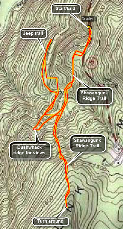 The Shawangunk Ridge Trail runs from High Point State Park in New Jersey to Sam's Point Preserve, The hike may be broken into sections. This section is an out and back hike from Route 52 outside of Ellenville near the Sam's Point Preserve.
Park in the pull off 1.7 miles south of South Gully on Route 52 heading out of Ellenville. Walk along side the road for about .2 miles and turn right into the woods on the Shawangunk Ridge Trail. At .55 miles there is a confusing junction but this offers some options. Bearing slightly right and up the ridge leads to a series of views but not much else. Turning sharply tot the right leads down along Old Route 52 but requires a very long walk to reach any real destination. Continuing straight ahead keeps you on the Shawangunk Ridge Trail. The trail climbs to near the highest point on the ridge over the next .7 miles. It then rolls along the ridge toward Ellenville. Walk as far as you like and then return to your car.
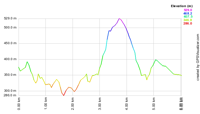
(The image above shows the profile of the hike. Remember that all vertical profiles are relative!)
Shawangunk Ridge Trail: Graham Fire Tower
| Quick Look | ||||
|---|---|---|---|---|
| Difficulty | Round trip | Total climb | Internet Maps | |
| 5.3 mi. | 800 ft. | AllTrails | ||
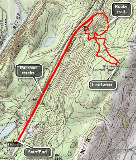 Drive to the hamlet of Godeffroy on Route 209 about 5.5 miles north of Port Jervis. Watch for the Guymard Turnpike on the east side of the road. Turn onto the turnpike and drive about .7 miles to a T. Turn right to follow the turnpike as it ascends and passes by one end of Guymard Lake. In about .2 miles park on the side of the road. The train tracks are active so look and listen before crossing to the other side to pick up the Shawangunk Ridge trail. Turn left and head northeast on the wide and flat woods road that parallels the Conrail tracks. After 1.7 miles of absolutely flat walking, look for red blazes going up the hill to the right and turn onto another woods road. The road wanders up the mountain heading south, then east, then southeast. At a little over 2 miles you will cross the white trail that you will use on the way back. The fire tower shares the top of the hill with cell towers and a nice little cabin. There is an access road for the cell towers which would probably be the quickest and easiest route to the top. The entire first flight of treads on the tower is missing from the steps to discourage anyone from climbing on the now closed tower! Find the blazes of the white trail to start back to the car. At some points this trail comes very close to the edge of the cliff but there are no real views. The white trail twists and turns but heads generally north. This route is much more of a trail than the red blazed woods road you used on the way up. Parts of it are rough as it gets little use. The last .3 miles are a rather steep descent along a small stream. In this section there is barely a trail and lots of rocks to negotiate. After slightly over a mile, you will be back on the SRT just slightly north of the turn for the red trail. Turn left and enjoy the flat hike back to the car.
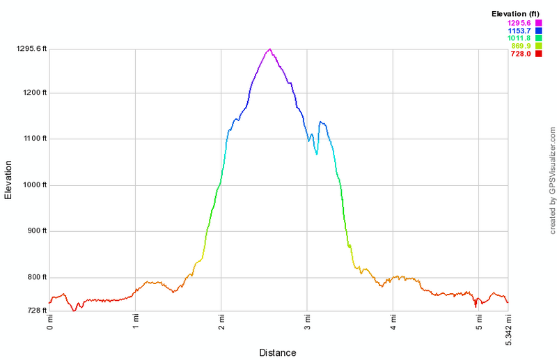
(The image at the left shows the profile of the hike.)
Shawangunk Ridge Trail: Guymard Turnpike to Hawthorne Lake
| Quick Look | ||||
|---|---|---|---|---|
| Difficulty | Round trip | Total climb | Internet Maps | |
| 10.4 mi. | 1794 ft. | AllTrails | ||
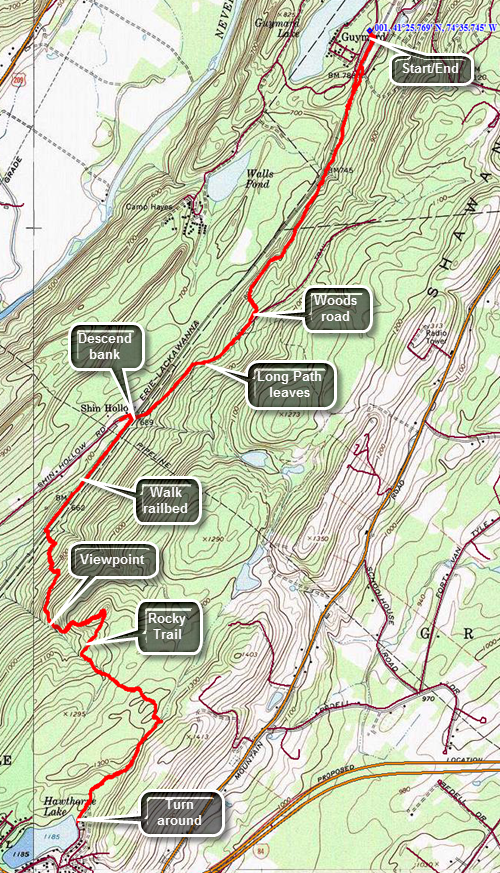 Drive to the hamlet of Godeffroy on Route 209 about 5.5 miles north of Port Jervis. Watch for the Guymard Turnpike on the east side of the road. Turn onto the turnpike and drive about .7 miles to a T. Turn right to follow the turnpike as it ascends and passes by one end of Guymard Lake. In about .2 miles park on the left side of the road. The train tracks are active so look and listen before crossing to the other side to pick up the Shawangunk Ridge Trail. Once you cross the tracks look for the aqua blazes of the Long Path on the left side of the right-of-way just before the underpass. Follow the trail down to a ditch and then up and across the Guymard Turnpike. Enter the woods on the other side of the turnpike. From this point on the trail rises and falls a little as you walk through both hardwood and softwood forest. Areas of the trail can be muddy and there are several small streams to cross and a few small "ponds". At 1.6 miles you will come to a woods road where you should turn right. Posted signs on both sides of the trail are a reminder to stay on the trail. At one point the Long Path cuts off to the left and the blazes change from the aqua Long Path blazes to the dark blue of the SRT. At 2.3 miles you will come to an old wooden bridge over the tracks and the trail blazes indicated a right turn. The bridge has been condemned and one look will tell you why! The trail descends the bank on the right side of the bridge. At the bottom turn left and walk along the right-of-way. The trail cuts into the woods near a stream at about 3.1 miles. Turn left and immediately start the biggest ascent of the day. Over the next .8 miles the trail climbs about 600 feet through several switchbacks and areas of very challenging trail. At times it seems you are walking in a rocky stream bed. At 3.6 miles there is an open rock face which serves as a nice lookout. You are now in Huckleberry Ridge State Forest. After finishing the climb there is a slight descent and then another ascent. There is one area of puncheons that can be very slippery. At 5.25 miles you will break out of the woods into the parking area near Hawthorne Lake. Just before the parking area is an unmarked trail to the right that goes near the shore of the lake. This is an out and back hike so turn around and retrace your steps when you are ready.
(The image at the left shows the profile of the hike.)
Shawangunk Ridge Trail: Haven Road to Wurtsboro VFW
| Quick Look | ||||
|---|---|---|---|---|
| Difficulty | Round trip | Total climb | Internet Maps | |
| 9.1 mi. | 400 | ft.AllTrails | ||
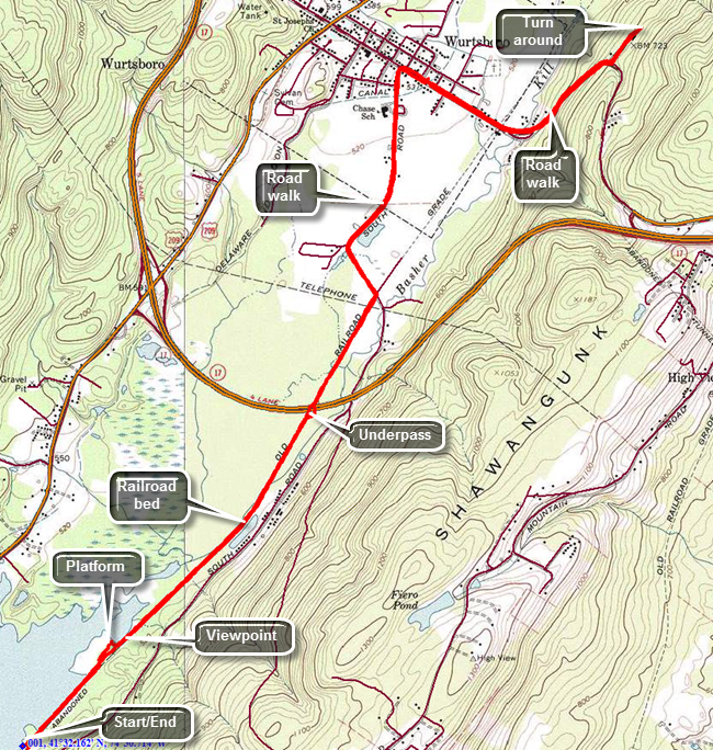 Take the Quickway (Route 17/I86) to the exit for Route 209 in Wurtsboro and head south toward Port Jervis. After about 2 miles turn left on Haven Road. Follow the road as it crosses over the Basha Kill. At the first intersection turn left and park in the large lot. Head northeast on the old railroad bed which makes up a good part of the SRT in this area. There are no blazes for either the SRT or Long Path but the route is clear as it simply follows the railbed. Within a short distance there is a nice viewpoint over the Basha Kill to the ridges beyond. You may encounter a few wet areas on the trail and some mud. There were also several places where old wooden bridges were cross the water. These bridges are slowly deteriorating and the whole atmosphere is one of neglect. At 1.8 miles there is an underpass beneath the highway allows hikers and wildlife to pass under the highway without a problem! At 2.3 miles the trail ends and the road walk begins. Turn left on South Road which eventually turns into Pennsylvania Avenue. It is rather pleasant walking on the flat and level road. As you near town, you will come across the D and H Canal Linear Park. A sign explains that Wurtsboro was named after Maurice Wurts who was the president and founder of the D and H Canal. There is also a stone snubbing post that was used to control the coal barges. When you arrive at Sullivan Avenue, the main street of Wurtsboro, turn right and head southeast, crossing the old railroad bed again at 3.8 miles. To this point the hike has been nearly flat gaining only 100 feet. This changes as you leave the Village of Wurtsboro and head up the hill to VFW Road. In truth the "climb" is only about 200 feet in .7 miles making an average grade of only 6%. Make the left turn onto VFW Road and hike a short distance to the post. The tail enters the woods from the parking area just beyond the post. The return trip is simply a reverse of the route from the way out since no viable loop options exist.
(The image above shows the profile of the hike. Remember that all vertical profiles are relative!)
Shawangunk Ridge Trail: South Gully to Shawangunk SF
| Quick Look | ||||
|---|---|---|---|---|
| Difficulty | Round trip | Total climb | Internet Maps | |
| 6.9 mi. | 1594 ft. | AllTrails | ||
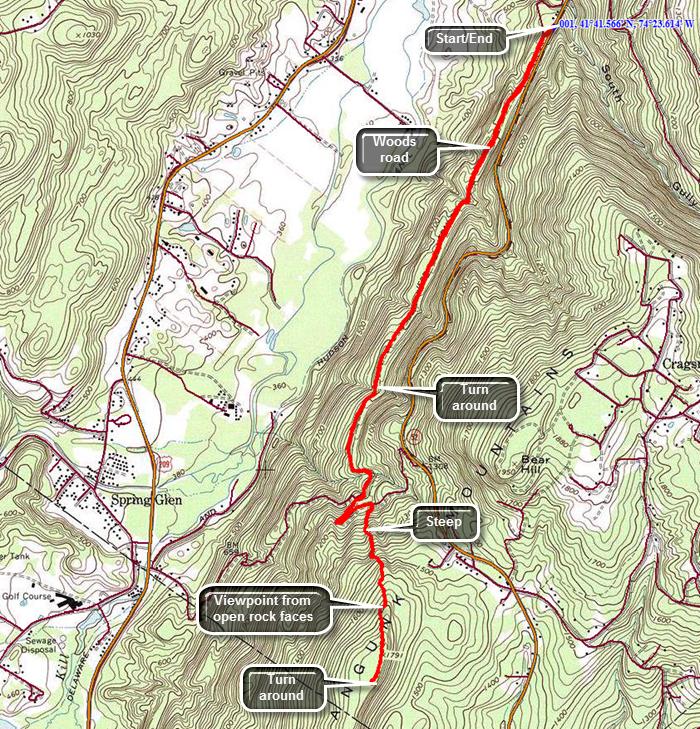 The Shawangunk Ridge Trail runs from High Point State Park in New Jersey to the Mohonk Preserve. The hike may be broken into sections. This section is an out and back hike from the South Gully Trail on Route 52 outside of Ellenville near the Sam's Point Preserve to the top of the first ridge.
Take Route 52 out of Ellenville and drive up the mountain heading toward Pine Bush. Pull over just after the South Gully bridge. Turn around and park on the wide shoulder near the trailhead. Cross the road to pick up the Long Path and SRT heading south. The trail descends from the road and the trail markings immediately disappear at a T! Turn left on what is marked on the maps as Old Route 52 and find the aqua blazes of the Long Path which seem to alternate with the dark blue blazes of the SRT. The road is wide and grassy at this point and is mostly uphill. Continue on the road which became MUCH rockier in places and continues to head uphill on a very slight grade. You will cross several small streams heading generally southwest. At 2.4 miles the trail suddenly turns 180 degrees and heads northeast to avoid descending into a deep ravine. At 2.6 miles you will reach a trail junction with the yellow connector trail which continues straight ahead to a parking area on Route 52. Turn right to stay on the Long Path and SRT. The trail immediately begins to climb up a ridge and is at times steep. There are open rock faces to climb over and some can be a little slippery from the accumulation of pine needles. Within a short distance there is an open rock face with some nice views to the west and north. The ascent continues for another .6 miles and gains 675 feet with an average grade of right around 20% but with some areas nearly 30%. You can turn around when you like but it is worth it to continue to the highest point on the ridge. In two or three more spots there are open views from rock faces. The trail begins to level off at 3.25 miles and can be quite overgrown by laurel and scrub oak. Walked a little farther to 3.5 miles and then turned around to head back
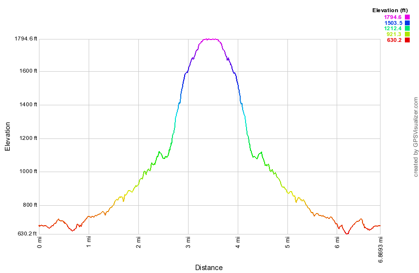
(The image above shows the profile of the hike. Remember that all vertical profiles are relative!)
Shawangunk Ridge Trail: Wurtsboro
| Quick Look | ||||
|---|---|---|---|---|
| Difficulty | Round trip | Total climb | Internet Maps | |
| 2.4 mi. | 660 ft. | AllTrails | ||
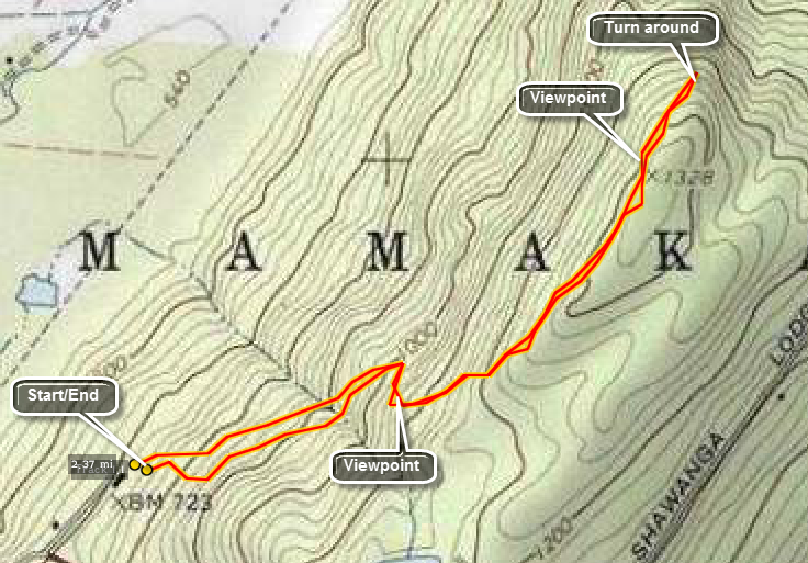 The Shawangunk Ridge Trail runs from High Point State Park in New Jersey to Sam's Point Preserve, The hike may be broken into sections. This section is an out and back hike from the VFW on VFW Road off Sullivan Avenue outside of Wurtsboro. Find the trail behind the VFW and begin to climb almost 600 feet in the next mile. As you climb onto the more exposed part of the ridge near the top, watch for views of the Catskills, the Basha Kill Wetlands and the valley below. Walk along the ridge for as long as you like but be aware that this is out and back. At about 1.2 miles the trail starts a serious descent and this may be a good time to turn around. Follow your path back to the car.
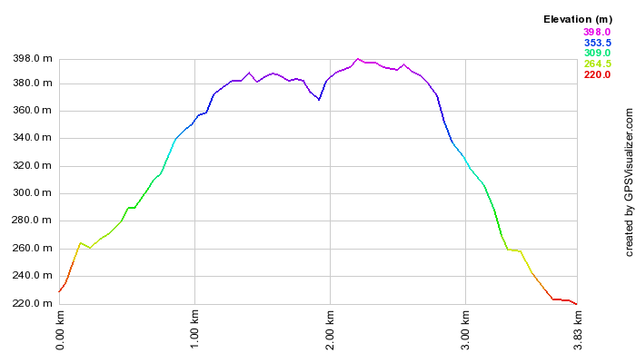 (The image below shows the profile of the hike. Remember that all vertical profiles are relative!)
Shawangunk Ridge Trail: Wurtsboro to Ellenville
| Quick Look | ||||
|---|---|---|---|---|
| Difficulty | Round trip | Total climb | Internet Maps | |
| 8.6 mi. | 2730 ft. | AllTrails | ||
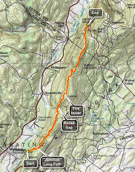 The Shawangunk Ridge Trail runs from High Point State Park in New Jersey to Sam's Point Preserve, The hike may be broken into sections. This section is a through hike from Wurtsboro north to Route 52 outside of Ellenville near the Sam's Point Preserve.
Park a car in the pull off 1.7 miles south of South Gully on Route 52 heading out of Ellenville. Drive to the VFW in Wurtsboro on VFW Road off Sullivan Avenue. You may use back roads to get to Wurtsboro or drive there on Route 209. The trail starts with a nice "warm up" of 600 feet of elevation gain over the first .95 miles. From here there are views of the Basha Kill to the southwest and the Catskills to the north. The Wurtsboro Airport and the massive Kohl's Distribution Center dominate the valley below. Immediately after the climb the trail descends into the next gap on the ridge. The descent is a little steep in places losing 400 feet in .45 miles. There is a small stream at the bottom just before the next climb. Over the next.9 miles the trail rises 470 feet but the reward are the views from the ridge. The views of the Catskills and the ridge across from the Shawangunk Ridge dominate the views. From this ridge you begin a steep descent to the lowest point on the route except for the very beginning. The trail drops 600 feet in the next .85 miles to Roosa Gap. There is another small stream here surrounded by ferns in season. Watch for the flowers from tulip trees in the spring and summer. The next section of the trail is a .7 mile climb that gains 725 feet. After this, the trail continues to rise but does so very gently for the next .8 miles. In the first part you will cross Roosa Gap Road. As you climb the ridge you can look back at the ridge you just left. At 5.15 miles the trail descends again and then begins to climb. The climb is gentle at first but then steepens some. This climb lasts 1.8 miles and rises to 780 feet, the highest point on this section of the trail. This part of the trail skirts the edge of the ridge before crossing over to the highest point. Along the way some interesting rock formations present themselves. One rock tower stands away from the edge of the cliff and is very interesting.
From the highest point the trail drops VERY steeply, losing 700 feet of elevation in about .5 miles. The trail makes its way down to the woods road that is the Old Route 52. The Long Path heads north from here as the road turns left. Pick up the yellow trail that leads UP to Route 52 where your car is parked. This trail is less than 1 mile long and passes over a small stream with a waterfall. From that point there is a short but steep ascent to the main road. As you turn left on Route 52 to get back to the parking area, watch for hang gliders plying the air currents above the area. Also take advantage of the beautiful views from the parking areas along the road. Don't forget to go get your other car in Wurtsboro!
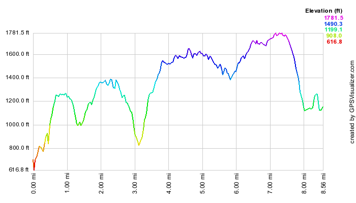 (The image at the left shows the profile of the hike. Remember that all vertical profiles are relative!)