
| Pick a Scary 19 Peak: |
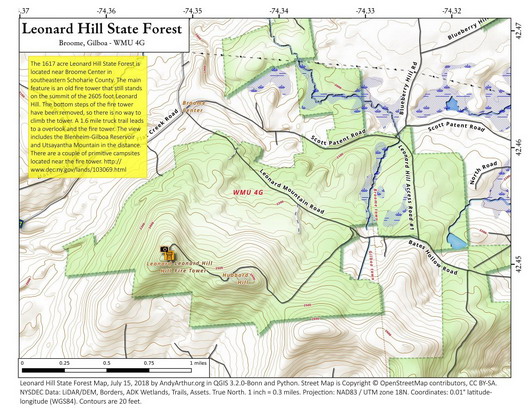
Leonard Hill
Leonard Hill is located in the Leonard Hill State Forest and is often combined with a visit to Hubbard Hill. It can be accessed by climbing from DEC listed parking areas at Broome Center Road, Blueberry Hill Road, Federal City Road, and the most common, Leonard Mountain Road. Leonard Hill offers a viewpoint to the North and also the Leonard Hill Fire Tower (currently not climbable). It can also be reached from NYC DEP watershed land from Hubbard Road with two access locations. Federal City Road and the further West access, on Hubbard Road are the most challenging.
Clicking on the map below will allow you to download a full page, printable PDF map. (Courtesy of Andy Arthur)
| Quick Look - from Leonard Hill Road | ||||
|---|---|---|---|---|
| Difficulty | Round trip | Total climb | Internet Map | Parking |
| 3.3 mi. | 570 ft. | AllTrails | N42.4533 W74.3321 | |
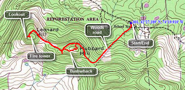
Drive to Broome Center, New York in Schoharie County. Turn southeast on Leonard Mountain Road. Drive 1.2 miles on a seasonally maintained road to a pulloff on the left side of the road. A little further up the road will be woods road on the right and there may be signs for Leonard Hill State Forest. Park in the pull off if possible. The availability of parking depends on the season. From the pulloff walk up the road to the woods road on the right. Start out and stay on the wide woods road that ascends the hill. After .65 miles at the top of the ridge the trail will turn right and begin to skirt Hubbard Hill on the left. At about 1 mile turn off the trail to the left and begin the bushwhack of Hubbard Hill. After passing over the summit turn west and descend the summit to rejoin the woods road at about 1.2 miles. (This bushwhack can also be done on the return trip.) Follow the woods road as it turns northwest toward the Leonard Hill fire tower. At 1.6 miles the trail turns southwest and arrives at the fire tower clearing after only .1 miles. The total distance to the tower is about 1.7 miles. The tower is presently closed to the public and the first two flights of stairs are missing. Fortunately there is a nice viewpoint nearby that will have to do until the fire tower is restored. When you are done, start back the way you came. You can stay on the woods road the whole time and avoid the bushwhack over Hubbard Hill.
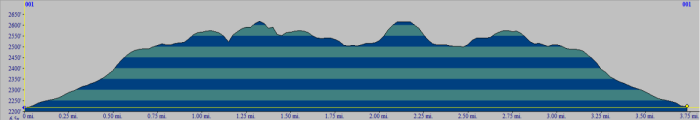 (The image shows the profile of the hike. Remember that all vertical profiles are relative!)