
Jennings Mountain
| Quick Look | |||||
|---|---|---|---|---|---|
| Difficulty | Round trip | Total climb | Location | Elevation | Internet Maps |
| 1.23 mi | 654 ft | N41.1679 W74.3164 Passaic | 1072 ft | AllTrails | |
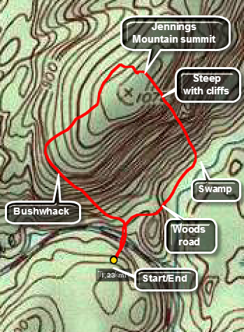 Head north on East shore road from the Warwick Greenwood Lake Turnpike east of Greenwood Lake. At 1.7 miles on the road starts to turn to the left and there will be a bridge across the stream on the right. The bridge has a gate and is not in great shape. Park on the south side of East Shore Road near the yellow gate. Walk across the road and start to walk north on a woods road. Sooner or later you will have to start your bushwhack. The south side of the mountain is not as steep as the east side so I started the bushwhack just after getting onto the road. The woods are open but the ascent can be steep. There are some woods roads and ATV trails to follow to the northwest. At around .35 miles, I turned 90 degrees and headed northeast toward the summit which I hit and .68 miles. For variety head southeast off the summit and descend through some interesting cliff bands. At .92 miles you should be off the ridge and near the swamp. Turn right on the path or road and walk out to the car. This return route may be a better choice to get to the top.
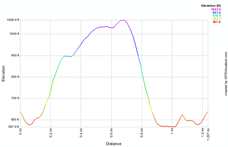 (The image at the left shows the profile of the hike. Remember that all vertical profiles are relative!)