
High Point
| Quick Look | |||||
|---|---|---|---|---|---|
| Difficulty | Round trip | Total climb | Location | Elevation | Internet Maps |
| 9.38 mi | 2046 ft | N41.321 W74.6615 Sussex | 1803 ft | AllTrails | |
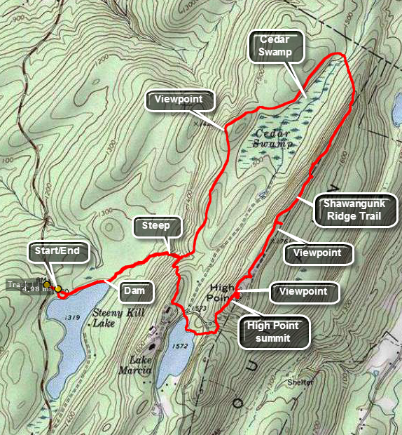 There are many different trails to get to High Point or you can simply drive to the top. This one has some nice views along the way there and back.
Start south on Route 23 from Port Jervis. As you drive up the mountain toward the main entrance to High Point, watch for a sign on the left for the Steeny Kill boat launch. Park in the Steeny Kill boat launch lot. Walk out toward the lake and you will see the blue blazes of the Steeny Kill Trail. Walk this trail over the dam that creates the lake. As you face the lake look for the cabins on the shore to your right. These were built by the CCC and now are designated "family" cabins. At about .75 miles the trail will start to ascend and then it will meet the red and green blazed monument trail which ascend to the roads near Lake Marcia at about 1.0 miles. Walk to the shore of the lake and head toward the eastern shore where the trail turns east and ascends to a park road which you must cross. Just after the road crossing the trail turns sharply to the left or northeast and ascends to the monument. After getting some views from the area of the monument, continue northeast along the ridge checking for viewpoints as you go. At about 2.85 miles the Monument Trail starts to descend off the ridge toward Cedar Swamp. At about 3.0 miles into the hike, you will be at the trail junction with the Cedar Swamp Trail. Turn left to investigate this habitat or continue straight ahead and follow the Monument Trail. At about 3.7 miles there will be another nice viewpoint worth a stop. Continue along the ridge watching for lookouts. At about 4.35 miles you will be back at the Steeny Kill Trail junction where you can turn right and go back to the car.
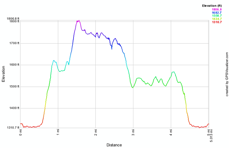 (The image at the left shows the profile of the hike. Remember that all vertical profiles are relative!)