
What You Missed
Winter 2013-2014
Winter 2013-2014
![]()
![]()
![]()
![]()
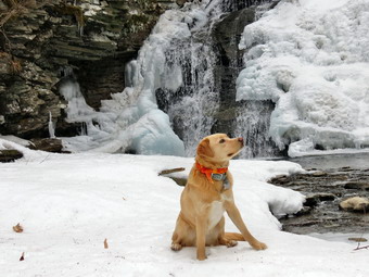
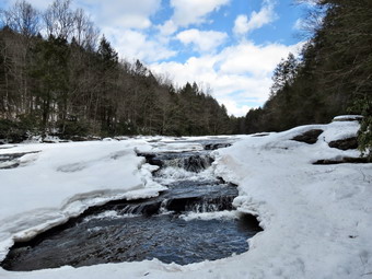
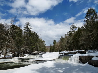
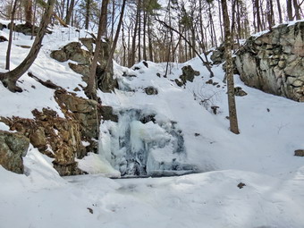
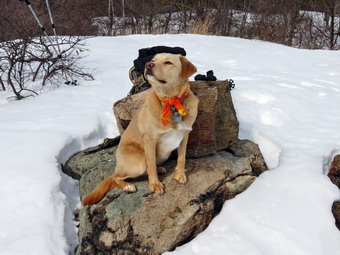
![]() On Wednesday, March 19th I wanted to get in a final hike for the winter season. I wanted to go close to home and thought some company would be nice so I called Lisa and she readily agreed to go. We decided to visit Trout Pond which is a favorite although I had not been there since January. I didn't know what to expect as far as trail conditions and the volume of water at the falls Lisa arrived at 9:00 AM and I already had Sheila and my gear in the car. After several hikes without snowshoes when snowshoes were needed I had put both spikes and snowshoes in the car. By the time we left the house the temperature was in the high 20's. As we drove up Morton Hill Road just outside of Roscoe the amount of snow on the ground started to increase. There was a lot of snow and ice where I parked along the side of Morton Hill Road near Russell Brook Road at about 9:30 AM. It appeared that Russell Brook Road was covered in ice and solidly frozen snow. Someone had tried to take a vehicle down the road and had chopped up the snow near the junction with Morton Hill Road. Before we started our hike, Lisa and I both decided to put on our spikes. As we started down Russell Brook Road, it seemed the spike were a good choice as the road was slippery with ice and frozen snow. We did see one set of footprints that seemed fresh. Before we reached the viewpoint over the upper falls, we could hear the sound of the water. One look showed that the volume was not as great as in January but that the falls were still pretty. We walked down to the lower parking area which was empty but completely snow covered. From there we headed down to the bridge over Russell Brook. We crossed the bridge and I decided to go over to the lower falls. The trail had melted out some but became slipperier as we walked up the path to the falls viewpoint. Lisa decided to go to the upper viewpoint while Sheila and I carefully made our way down to the streambed. I took pictures of the falls and the frozen water beside it. The ice on the left side of the falls was a deep blue color. I took a few shots with Sheila in front of the falls and then we climbed back up the bank and walked out to the main trail.
On Wednesday, March 19th I wanted to get in a final hike for the winter season. I wanted to go close to home and thought some company would be nice so I called Lisa and she readily agreed to go. We decided to visit Trout Pond which is a favorite although I had not been there since January. I didn't know what to expect as far as trail conditions and the volume of water at the falls Lisa arrived at 9:00 AM and I already had Sheila and my gear in the car. After several hikes without snowshoes when snowshoes were needed I had put both spikes and snowshoes in the car. By the time we left the house the temperature was in the high 20's. As we drove up Morton Hill Road just outside of Roscoe the amount of snow on the ground started to increase. There was a lot of snow and ice where I parked along the side of Morton Hill Road near Russell Brook Road at about 9:30 AM. It appeared that Russell Brook Road was covered in ice and solidly frozen snow. Someone had tried to take a vehicle down the road and had chopped up the snow near the junction with Morton Hill Road. Before we started our hike, Lisa and I both decided to put on our spikes. As we started down Russell Brook Road, it seemed the spike were a good choice as the road was slippery with ice and frozen snow. We did see one set of footprints that seemed fresh. Before we reached the viewpoint over the upper falls, we could hear the sound of the water. One look showed that the volume was not as great as in January but that the falls were still pretty. We walked down to the lower parking area which was empty but completely snow covered. From there we headed down to the bridge over Russell Brook. We crossed the bridge and I decided to go over to the lower falls. The trail had melted out some but became slipperier as we walked up the path to the falls viewpoint. Lisa decided to go to the upper viewpoint while Sheila and I carefully made our way down to the streambed. I took pictures of the falls and the frozen water beside it. The ice on the left side of the falls was a deep blue color. I took a few shots with Sheila in front of the falls and then we climbed back up the bank and walked out to the main trail.
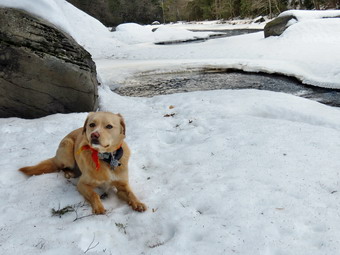
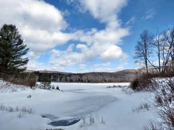
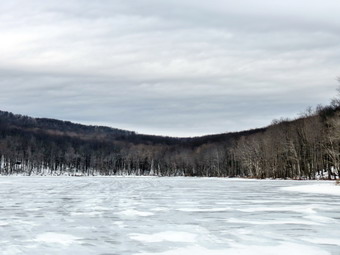 At the split in the trail we headed right to do the loop in a counterclockwise direction. There was snow and ice covering the entire trail but it wasn't very deep. We set a fast pace up the trail toward Trout Pond and as we approached we could see there was ice covering all of the pond except the part near the spillway. Lisa and I both took some pictures of the scenery with the ice on the pond. The sky was overcast but there was enough light to provide some interesting shots. I threw a stick out onto the ice for Sheila to retrieve and took pictures as she returned with it. We headed back to the main trail and walked up to the inlet end of the pond. We walked to the upper end of the pond and found no one at the lean-tos which was not really surprising. Lisa wanted to take some shots from the upper end of the pond but the wind was blowing hard enough to make me want to continue into the woods. We found that snowmobiles had been on the trail up Cherry Ridge and that this had packed the snow making our hike easier. As we began to ascend, the trail stayed firm with packed snow and ice. The snow and ice continued to the top of the rise and right and down the other side to the junction with e woods road passed Mud Pond. We were setting a fast pace of about 2.7 miles per hour and the 2 mile hike from Trout Pond to Mud Pond seemed to go very quickly. We turned left and found more packed snow and ice on the snowmobile trail as we climbed a little before descending. The descent back to the trail register usually has less snow and ice since it is more exposed to the sun. On this day the packed snow continued and the descent was swift. We were soon back at the trail junction where I signed in at the register box. We walked back to the lower falls since Lisa wanted to get some pictures from the streambed. Sheila and I went to the upper lookout and then we all met back at the main trail. From there we walked back out to the lower parking area and then up the road to the car. We were back at the car at 12:05 PM having covered 5.7 miles in 2 hours and 30 minutes.
![]()
![]()
![]()
![]()
![]() On Saturday, March 15th I had planned to head for Slide Mountain to hike from Route 47 up the Curtis Ormsbee Trail and then down the main route back to the car. Cindy consulted the weather map and warned me that I might run into a cold rain if I went north. She also reminded me that we had encountered a full parking area the Saturday before and suggested I head a little south. It wasn't what I really wanted to do but I decided to head for the Neversink Unique area and to hike along the river. I thought I could get a good workout if I went far enough. I also hoped to get some good pictures of Denton Falls and High Falls with ice still on the river. I got Sheila in the car and we headed down Route 17 toward Rock Hill. I had packed both spikes and snowshoes and would make a decision at the trailhead. As we passed Monticello it began to sprinkle but I decided to continue. I turned off the exit onto Katrina Falls Road and we arrived at the trailhead parking at about 10:30 AM. The rain had stopped and I got out to inspect the trail. There was still quite a bit of snow but it was all well-packed and frozen. It was also obvious that no one had worn snowshoes since the path was chopped up across its entire width. I though wearing snowshoes would be difficult and that carrying them was unnecessary. I put on my spikes and we headed out at about 10:40 PM under partly sunny skies. It was no easy walking on the trail as it was so uneven! We soon crossed the small bridge over Wolf Brook and arrived at the first trail junction. It was obvious no one had done the loop in some time as there was no path broken on the trail to the left. We stayed to the right on the main trail that parallels the Neversink River. The trail entered the trees and, while still rough and uneven, the hiking was pretty easy as I could stay on top of the snow. We crossed Mullet Brook on the bridge and I stopped to see if I could take some pictures. Even in the woods the snow was "dirty" and there were no interesting shots. We climbed the little hill and then went off the main trail to the right to go down to Denton Falls. I was surprised to find no path on the trail indicating that no one had been down to the falls in some time. The sun had been in and out behind the clouds but the temperature was beginning to rise into the 40's. The combination of no previous visitors and rising temperature began to cause problems. I was beginning to sink in some as I descended the hill to the river and I wondered how bad it would get. There didn't seem to be more that a foot of snow in most places and we made good progress. The trail is not very well marked but Sheila was able to pick it out with no problem. We arrived at the river at about 11:25 Am after hiking about 1.6 miles. I was careful where I stepped since I was not sure what was ice over rocks and what was ice over water. I took off my pack and began to take some pictures. The sky upriver was very blue with just enough cloud cover. There was still a lot of ice on the river but the falls were flowing nicely. I took some pictures, repositioned and took some more. After a little less than 10 minutes, we headed back to the bank and the long climb back to the main trail. Even though I was sinking into the snow some the climb seemed easy and we were soon back on the main trail.
On Saturday, March 15th I had planned to head for Slide Mountain to hike from Route 47 up the Curtis Ormsbee Trail and then down the main route back to the car. Cindy consulted the weather map and warned me that I might run into a cold rain if I went north. She also reminded me that we had encountered a full parking area the Saturday before and suggested I head a little south. It wasn't what I really wanted to do but I decided to head for the Neversink Unique area and to hike along the river. I thought I could get a good workout if I went far enough. I also hoped to get some good pictures of Denton Falls and High Falls with ice still on the river. I got Sheila in the car and we headed down Route 17 toward Rock Hill. I had packed both spikes and snowshoes and would make a decision at the trailhead. As we passed Monticello it began to sprinkle but I decided to continue. I turned off the exit onto Katrina Falls Road and we arrived at the trailhead parking at about 10:30 AM. The rain had stopped and I got out to inspect the trail. There was still quite a bit of snow but it was all well-packed and frozen. It was also obvious that no one had worn snowshoes since the path was chopped up across its entire width. I though wearing snowshoes would be difficult and that carrying them was unnecessary. I put on my spikes and we headed out at about 10:40 PM under partly sunny skies. It was no easy walking on the trail as it was so uneven! We soon crossed the small bridge over Wolf Brook and arrived at the first trail junction. It was obvious no one had done the loop in some time as there was no path broken on the trail to the left. We stayed to the right on the main trail that parallels the Neversink River. The trail entered the trees and, while still rough and uneven, the hiking was pretty easy as I could stay on top of the snow. We crossed Mullet Brook on the bridge and I stopped to see if I could take some pictures. Even in the woods the snow was "dirty" and there were no interesting shots. We climbed the little hill and then went off the main trail to the right to go down to Denton Falls. I was surprised to find no path on the trail indicating that no one had been down to the falls in some time. The sun had been in and out behind the clouds but the temperature was beginning to rise into the 40's. The combination of no previous visitors and rising temperature began to cause problems. I was beginning to sink in some as I descended the hill to the river and I wondered how bad it would get. There didn't seem to be more that a foot of snow in most places and we made good progress. The trail is not very well marked but Sheila was able to pick it out with no problem. We arrived at the river at about 11:25 Am after hiking about 1.6 miles. I was careful where I stepped since I was not sure what was ice over rocks and what was ice over water. I took off my pack and began to take some pictures. The sky upriver was very blue with just enough cloud cover. There was still a lot of ice on the river but the falls were flowing nicely. I took some pictures, repositioned and took some more. After a little less than 10 minutes, we headed back to the bank and the long climb back to the main trail. Even though I was sinking into the snow some the climb seemed easy and we were soon back on the main trail.
 Just up a short hill was the next trail junction. The trail to the left was the trail that started the loop back to the car. Along the way a trail leads Donte the falls on Mullet Brook. The trail to the right continues to parallel the river and ends at High Falls. Beyond that a series of woods roads leads to the southern part of the Neversink Unique area near Westerbrookville. The trail to the left showed some travel while the one to the right was not broken. I really wanted to get to high falls so we turned right. Almost immediately I knew that this part of the hike was going to be difficult. The snow was deeper and softer than anywhere else we had hiked so far. I began to sink in every few steps. Sometimes I only sank a few inches but other times it was deeper. The footing was very unpredictable and I wasn't sure exactly how far High Falls was along the trail. I debated turning back but thought I could make it without any problems. The trail rolls a little but eventually drops down to the river and a lower elevation than Denton Falls! The total distance was 2.1 miles but it seemed farther. Finally we made the turn down toward the river. We came across a large patch of deer hair with a foot square piece of hide. This was all that was left after the coyotes had finished off the whitetail. I encouraged Sheila to move along! When we got to the river bank, I was careful to stay in areas where I knew there were rock ledges underneath. Sheila was not so careful and I kept calling her back to me. I dropped my pack and got out the camera to take pictures. High falls is only slightly higher than Denton Falls but it has two different sections and is much wider. The skies were blue and I took shots both up and won the river. The wind started to blow a little and I began to get cold so I shouldered my pack and we headed back up the trail
 The walk back was extremely difficult as the snow was even softer. I was sinking in more often and deeper. It was still unpredictable and the whole process was taking a toll on my arms and especially on my calves. My calf muscles felt as if they were going to cramp at any moment. This was more from the exertion than dehydration. In one spot I had to go off the trail to avoid a major blowdown. I climbed up some piles of snow which had supported my weight on the way out. I knew there was brush underneath these piles which I conformed the hard way. Several times I sank above my knees negotiating this detour. The two miles back to the packed main trail was some of the hardest work I have done in some time. Once we got to the main trail, I decided to forgo a visit to Mullet Falls. The side trail wasn't too far up the hill but I knew I would have to walked down the side trail to the brook and then back up. In addition, I would have to walk the unbroken trail around them loop or return to where I currently was standing. I was not really prepared for either of these options. We turned left and headed back to the car the way we had come. I knew I had made the right decision when I began sinking into the snow that had been packed and frozen on the way out. I struggled along taking a few breaks here and there. At one point a family of three passed us and we said hello but kept moving. We crossed Wolf Brook again and then turned right to head up the hill and back to the car. The last half mile ascended only 200 feet which is about and 8% grade but I really had to push myself to keep going. We were back at the car at 3:15 PM having covered 7.6 difficult miles in 4 hours and 40 minutes.
![]() On Saturday, March 8th I wanted to do a hike that Cindy could manage but with some distance or difficulty or both. The weather report called for clear skies with temperatures rising above freezing later in the day. I proposed we hike Hunter from Spruceton but she thought that might be too difficult. We decided to head for Slide from Route 47 as it was closer and is only a six mile round trip. We had some work to do around the house before leaving and didn't get going until after 10:00 AM. Sheila was certainly ready to go and made a dash for the car. We had learned our lesson from a previous hike and put the snowshoes and the spikes in the car. When we got to the Slide Mountain parking area we found it almost full. I could have carved out a place to park but did not relish having to put Sheila on a leash for a good part of the hike. We continued on to the Giant Ledge and Panther parking area but found a similar situation. I decided that we would go to Lost Cove and hike to Belleayre from there. I thought there would be fewer people at this location and I had not hiked it in over 4 years! When we arrived in the parking area just before 11:30 AM, we found no others cars parked there. We got out of the car, made the decision to wear snowshoes and were soon on our way. There was a faint path on the trail which had some well packed snow. We could not decide what had made the path as it looked too smooth for a snowmobile and finally deiced it may have been a sled. It was evident someone had own snowshoes at one point but that others had worn just boots. Just as I remembered, the trail started to climb right out of the parking area and averaged just under a 20% grade. I was making good progress but when I looked back Cindy was pretty far behind. I waited until she caught up and then started in again. There was some sun and the temperature was warm compared to many days during the winter. To the left we could see Balsam Mountain looking very high and impressive. When the trail got steeper, we tried the "televators" on the snowshoes which did seem to easy the strain on our calves. We both wore Atlas snowshoes and had problems getting the heel lifts to go down easily. It seems that snow had melted and then frozen on the lifts and it took some effort to get our feet flat again. I was having a good workout but Cindy continued to struggle on the steep hill. At around 1:00 PM after hiking only 1.3 miles in 1.5 hours, Sheila and I hit the Pine Hill - West Branch Trail. Cindy was out of sight so I decided to hike as fast as I could to the lean-to at about 1.5 miles and then turn around, find Cindy and return to the car. It only too us 1o minutes to hike the .3 miles to the lean-to. We turned around and found Cindy not far behind. We turned around and headed back in the softened snow. It had taken us about and hour and 45 minutes to hike to the lean-to. On the way back we were able to slide on our snowshoes or take some long steps down the steep trail. We saw no one else all day. We were back at the car at 1:45 PM. The descent had taken only 40 minutes!
On Saturday, March 8th I wanted to do a hike that Cindy could manage but with some distance or difficulty or both. The weather report called for clear skies with temperatures rising above freezing later in the day. I proposed we hike Hunter from Spruceton but she thought that might be too difficult. We decided to head for Slide from Route 47 as it was closer and is only a six mile round trip. We had some work to do around the house before leaving and didn't get going until after 10:00 AM. Sheila was certainly ready to go and made a dash for the car. We had learned our lesson from a previous hike and put the snowshoes and the spikes in the car. When we got to the Slide Mountain parking area we found it almost full. I could have carved out a place to park but did not relish having to put Sheila on a leash for a good part of the hike. We continued on to the Giant Ledge and Panther parking area but found a similar situation. I decided that we would go to Lost Cove and hike to Belleayre from there. I thought there would be fewer people at this location and I had not hiked it in over 4 years! When we arrived in the parking area just before 11:30 AM, we found no others cars parked there. We got out of the car, made the decision to wear snowshoes and were soon on our way. There was a faint path on the trail which had some well packed snow. We could not decide what had made the path as it looked too smooth for a snowmobile and finally deiced it may have been a sled. It was evident someone had own snowshoes at one point but that others had worn just boots. Just as I remembered, the trail started to climb right out of the parking area and averaged just under a 20% grade. I was making good progress but when I looked back Cindy was pretty far behind. I waited until she caught up and then started in again. There was some sun and the temperature was warm compared to many days during the winter. To the left we could see Balsam Mountain looking very high and impressive. When the trail got steeper, we tried the "televators" on the snowshoes which did seem to easy the strain on our calves. We both wore Atlas snowshoes and had problems getting the heel lifts to go down easily. It seems that snow had melted and then frozen on the lifts and it took some effort to get our feet flat again. I was having a good workout but Cindy continued to struggle on the steep hill. At around 1:00 PM after hiking only 1.3 miles in 1.5 hours, Sheila and I hit the Pine Hill - West Branch Trail. Cindy was out of sight so I decided to hike as fast as I could to the lean-to at about 1.5 miles and then turn around, find Cindy and return to the car. It only too us 1o minutes to hike the .3 miles to the lean-to. We turned around and found Cindy not far behind. We turned around and headed back in the softened snow. It had taken us about and hour and 45 minutes to hike to the lean-to. On the way back we were able to slide on our snowshoes or take some long steps down the steep trail. We saw no one else all day. We were back at the car at 1:45 PM. The descent had taken only 40 minutes!
On Thursday, March 6th, I wanted to get out of the house but I didn't have much time. I decided to go across the street and hike a short route on Round Top. It was still a little cold to take Bryce out but Sheila seemed more than willing to go. We headed across the street at about 11:30 AM. I had decided not to repeat my mistake from Tuesday at Frick Pond. On that hike I had thought spikes would be enough as the snow was frozen. This was true for most of the hike but not for the return trip on the Flynn Trail. On this day I put the snowshoes on a the end of the driveway and wore them for the entire hike. Even as we started up the hill behind the church, it was obvious that snowshoes had been the correct decision! I stayed on the unbroken snow as several people had postholed in boots. I had decided not to wear my pack and the freedom was welcomed. At the top of the hill we turned left into the woods and shortly after that right onto another woods road. We followed our usual route up the hill and passed the quarry. We descended the hill without actually getting to the summit of Round Top and then started up the next hill. Some of the trails were packed by snowmobiles but most were unbroken and the snowshoes REALLY helped. I got a nice slide down the other side of the hill and we were soon making the turn to head back. This part of the hike usually seems long but on this day it seemed to fly by. We made the circle to complete the loop to the base of the second hill. From There it was a short climb to the quarry and then a long downhill stretch back to the cemetery. We spent a little over an hour hiking a little more than two miles which was much better than staying in the house all day!
On Tuesday, March 4th, I wanted to go out to snowshoe again on the hard, crusted snow. I wasn't really thinking about doing a mountain so I decided to go to the Frick Pond area again. Going to Frick Pond has both advantages and disadvantages. I know the area very well and can pick different trail combinations but it still is boring to do the same hikes again and again. This time Lisa wanted to go so I would have someone to talk to as we hiked. We decided to hike at around 10:00 AM but Lisa had some things to do so we didn't get to the trailhead until almost 11:00 Am. We had decided that the crust was hard enough to just wear spikes. There was a crew from the DEC returning to the parking lot after erecting new signs. Lisa talked to them for a few minutes before we headed out the Quick Lake Trail toward Frick Pond. Lisa had not been on the trail for some time while it was at least my fifth time in the last few weeks. We crossed the outlet to the pond on the new bridge and I was able to resist taking the same pictures I have taken so many times before. The sky was overcast and the cold weather had completely frozen the surface of the pond and the outlet stream. When we got to the next trail junction, we stayed to the right to continue around Frick Pond rather than taking the Quick Lake Trail. The snow was very hard and we had no trouble staying on top with spikes. Some of the snow weighing down the ranches on this route had fallen making the path easier to negotiate. At Times Square we continued straight ahead up the Big Rock Trail toward the junction with the Flynn Trail. The Big Rock Trail is a continuous ascent but being able to talk to someone made the trip seem faster. Since the Big Rock Trail is a snowmobile trail, the snow was packed even harder making waking very easy. At about 1.9 miles an unmarked snowmobile trail headed off to the right and we decided to follow it to where it rejoined the Big Rock Trail. It was only about a .2 mile "detour" but it was fun to try a new route. We were soon at the junction with the Flynn Trail where we turned right to start back to the car. The temperature was still below freezing but the sun was out. The rising temperature and the direct sun had softened the snow enough that we began to sink in! This trail also seemed to be less traveled. It was pretty miserable as we were sinking in every fifth step, in some cases, up to our knees. Staying on the "broken" path helped some but not much. As we continue on the trail it seemed that more snowshoes had come up from the parking area and then turned around. This should have made travel easier but these hikers seemed inexperienced with snowshoes. Instead of walking behind each other to form a nice trail, they had walked parallel. This had the effect of not packing a good trail and chewing up the snow across the entire width of the wide woods road! This part of the hike was NOT much fun but we were back at the car by 1:10 PM. We had hiked 4 miles in about 2 hours and 15 minutes with several stops for Lisa to snap some pictures.
![]()
![]()
![]()
![]()
![]() On Saturday, March 1st I was ready to get out and hike a mountain or at least leave the Livingston Manor area. Cindy suggested we head south so that it would be little warmer. I agreed as temperatures near single digits are a little low for Sheila on a prolonged hike. I looked at several different possibilities in the Harriman area but wasn't completely decided when we left the house. I had packed spikes and put snowshoes in the car as I was not sure what to expect. As we drove down the Quickway, I though that Cindy might enjoy hiking to Fitzgerald falls on the AT. We could continue after that to the junction with the Highlands Trail and maybe even make it to Little Dam Lake. From Route 17 in Goshen I headed for Warwick and then took Route 17A toward Greenwood Lake. At the bottom of the hill I turned left on Lakes Drive and headed north. Somehow I missed the place where the AT crossed the road but found it as we doubled back. There was no room to park along the side of the road but I found a small pullout that was plowed. It didn't seem that I was blocking anything and there was no sign prohibiting parking. We were parked at 11:30 AM and were ready to hike soon after. We decided that the snow was form enough to just use spikes. The trail to the falls showed evidence of a lot of bareboot traffic and postholing from before the snow had hardened. This made walking difficult which was solved by simply walking on the untouched snow. It is about .25 miles to the falls where we stopped and took some pictures before tackling the climb to the top of the falls. The trail has some nice stone steps but these were completely covered by hard snow and ice. We were glad we had spikes and poles as we hiked up the rather steep section. From the top of the falls the AT heads east for 1.3 miles gaining some 700 feet to the top of a ridge. The trail is marked only with the white AT blazes which are pretty far apart and faded in many places.
On Saturday, March 1st I was ready to get out and hike a mountain or at least leave the Livingston Manor area. Cindy suggested we head south so that it would be little warmer. I agreed as temperatures near single digits are a little low for Sheila on a prolonged hike. I looked at several different possibilities in the Harriman area but wasn't completely decided when we left the house. I had packed spikes and put snowshoes in the car as I was not sure what to expect. As we drove down the Quickway, I though that Cindy might enjoy hiking to Fitzgerald falls on the AT. We could continue after that to the junction with the Highlands Trail and maybe even make it to Little Dam Lake. From Route 17 in Goshen I headed for Warwick and then took Route 17A toward Greenwood Lake. At the bottom of the hill I turned left on Lakes Drive and headed north. Somehow I missed the place where the AT crossed the road but found it as we doubled back. There was no room to park along the side of the road but I found a small pullout that was plowed. It didn't seem that I was blocking anything and there was no sign prohibiting parking. We were parked at 11:30 AM and were ready to hike soon after. We decided that the snow was form enough to just use spikes. The trail to the falls showed evidence of a lot of bareboot traffic and postholing from before the snow had hardened. This made walking difficult which was solved by simply walking on the untouched snow. It is about .25 miles to the falls where we stopped and took some pictures before tackling the climb to the top of the falls. The trail has some nice stone steps but these were completely covered by hard snow and ice. We were glad we had spikes and poles as we hiked up the rather steep section. From the top of the falls the AT heads east for 1.3 miles gaining some 700 feet to the top of a ridge. The trail is marked only with the white AT blazes which are pretty far apart and faded in many places.
 At 1.7 miles the Highlands Trail headed right and the AT turned left. We turned right and walked to a nice viewpoint to the south where we could almost see part of Greenwood Lake. We returned to the trail junction to continue on the At but I could tell that Cindy was nearly at her limit. I decide we could make it to the Mombasha High Point which also had a nice view. The trail across the ridge was mostly flat and easy to walk. At 2.3 mile we were on the Mombasha High Point overlooking Lake Mombasha or the Monroe Reservoir. It was 1:15 PM when we stopped to take some pictures of the scenery. I also took some of Sheila. Sheila and I walked a few hundred feet further to another lookout to get a better view of the lake. To the east and north I could see a concentration of housing which I thought might be Kiryas Joel. We walked back to the High Point where we picked up Cindy and headed back. The temperature had risen into the 30's and the sun was out. This was encouraging except for the fact that the snow had softened just a little. We began to break through in spots that were solid on the way out. I realized that we had judged the trail conditions and temperature poorly and should have worn snowshoes for the whole hike. The walk back was mostly downhill but we were slowed by the conditions. By the time we got back to the falls the sun was out and we stopped again to take some shots. On our way back to the car we met a couple who seemed well-equipped for the hike to the falls! We were back a the car by 2:45 PM having covered 4.7 miles in 3 hours and 15 minutes. I was disappointed at the short distance but happy to have the company. On the way home we stopped at La Azteca in Florida. The food was OK but not especially authentic and could have used a little additional spice.
On Thursday, February 27th, I wanted to go out to snowshoe again on the hard, crusted snow. I wasn't really thinking about doing a mountain so I decided to go to the Frick Pond area again. Going to Frick Pond has both advantages and disadvantages. I know the area very well and can pick different trail combinations but it still is boring to do the same hikes again and again. I decided my objective this time would be to hike as quickly as I could and get as much elevation gain as I could. My plan was to hike out the Quick Lake trail and then take the Logger's Loop to the Big Rock Trail. The Big Rock trail has the most elevation gain in the shortest distance. This is a snowmobile trail so I expected it to be well packed. My plan after that was to take the Flynn Trail passed Hodge Pond to Junkyard Junction and then continue back to Frick Pond for between 6 and 8 miles. The mooning was COLD and I had some things to take care of around the house. By the time I got my gear rounded up and Sheila in the car it was 11:30 AM. We arrived at the trailhead parking at 11:45 AM. The snow was as hard as a rock but the parking area was completely bare! We got right on the trail with Sheila particularly eager to get going. I followed my plan and hiked out the wide woods road that is the start of the Quick Lake Trail. At the junction with the Logger's Loop headed right towards Times Square where we arrived at 12:10 PM after hiking a mile. As we made the right onto the Big Rock Trail it was clear there had been some significant snowmobile traffic and maybe even some grooming. I considered taking off the snowshoes but decided wearing them was less work than carrying them. The Big Rock Trail usually seems longer and steep than I remember and this day was no exception. Somewhere near the top Sheila ran back to me and as I stopped walking I could also hear the snowmobiles coming. Two riders passed us at a very slow speed and waved as they went by. By 12:45 PM we were at the junction with the Flynn Trail at the highest point on the hike. We had hiked 2.1 miles and I knew the rest of the hike was mostly downhill or flat. We turned left on the Flynn Trail and headed toward Hodge Pond. Sheila was criss-crossing the main trail following her nose. At some point I looked down and noticed some blood. I called her over and found she had a slight laceration or abrasion on her right dew claw. It seemed to be botheri8ng me more than her but after she cut her paw last year I am a little more careful. By 1:00 PM we were at Hodge Pond and the wind was blowing off the pond under grey skies. I continued on the Flynn Trail across the outlet and around the pond. We climbed a little on the trail and then passed the gate. It wasn't long before we were at Junkyard Junction. It was 1:30 PM and we had hiked 3.7 miles. We turned left on the Quick Lake Trail to head downhill to Iron Wheel Junction. As we hiked I debated whether to take the Loggers Loop or stay on the Quick Lake Trail. I decided to take the slightly shorter route and turned right to stay on the Quick Lake Trail at Iron Wheel Junction. The rest of the trip back seemed to go quickly as we crossed the outlet to Frick Pond and headed back to the car. I stopped for a moment at the headstone for the Lobdell children. I was surprised to find that someone had pushed it over or take it completely! After a little closer inspection, I realized that I was looking at the TOP of the headstone. There is still snow in the Catskills! We arrived back at the parking area at 2:45 PM. We covered 6.8 miles in a little over 3 hours which I considered a good pace.
![]() On Monday, February 24th, I was ready to try to snowshoe a longer loop and Frick and Hodge Ponds. The previous two hikes had ended with a very short loop around Frick Pond due to the deep snow (30+ inches) that made movement difficult. On these trips I had sunk at least 10 inches into the snow and then had to lift my foot out of that hole with snow on top of the snowshoe. In both cases I was the only one breaking the trail and quickly became tired. I expected different conditions this time as several warm days with a little rain had been followed by cold weather. I hoped that there would be a crust that would allow me to stay on top of the snow this time! My plan was to take the Quick Lake Trail to Iron Wheel Junction and then return on the Loggers Loop. The temperature when I awoke was about 18 degrees with a slight breeze. After completely some work, I got dressed, collected my gear, put Sheila in the backseat and headed out. We arrived at the Frick Pond parking area around 10:00 AM and got right on the trail. The temperature was only 21 degrees and the breeze had picked up so that it was blowing consistently. The parking area was almost bare and the larger lot had been plowed. We headed out on the Quick Lake Trail and it was immediately obvious that there would be little problem staying on top of the crusted snow. I followed the broken track in most places but tested the unbroken snow in others and was able to stay on top with no problem. As we walked down to Frick Pond the wind off the pond picked up. I stopped to take a few pictures but did so quickly as having my mitts off made for really cold hands. We continued on around the pond to the trail junction and veered to the left to stay on the Quick Lake Trail. I could see the track I had broken a week before but it was very shallow. When I had broken the track, it was at least 10 inches deep but now it was barely 2 inches. This was a testament to how the warm weather and light rain had consolidated the snow. As we approached the end of the broken path, I wondered whether I would be able to stay on top of the snow as easily. I needn't have worried as there didn't seem to be a difference from where the trail had been formed. Sheila meanwhile was having a great time running around as usual. She was breaking through in a few spots which didn't seem to bother her. I assumed this was due to her smaller footprint and to her bounding and jumping. I was glad that I had the snowshoes as I did think that bare boots would have probably penetrated he crust. By 10:45 AM we were at Iron Wheel Junction and I checked my GPS to find that our moving speed was 2.4 mph which I considered good for the conditions.
On Monday, February 24th, I was ready to try to snowshoe a longer loop and Frick and Hodge Ponds. The previous two hikes had ended with a very short loop around Frick Pond due to the deep snow (30+ inches) that made movement difficult. On these trips I had sunk at least 10 inches into the snow and then had to lift my foot out of that hole with snow on top of the snowshoe. In both cases I was the only one breaking the trail and quickly became tired. I expected different conditions this time as several warm days with a little rain had been followed by cold weather. I hoped that there would be a crust that would allow me to stay on top of the snow this time! My plan was to take the Quick Lake Trail to Iron Wheel Junction and then return on the Loggers Loop. The temperature when I awoke was about 18 degrees with a slight breeze. After completely some work, I got dressed, collected my gear, put Sheila in the backseat and headed out. We arrived at the Frick Pond parking area around 10:00 AM and got right on the trail. The temperature was only 21 degrees and the breeze had picked up so that it was blowing consistently. The parking area was almost bare and the larger lot had been plowed. We headed out on the Quick Lake Trail and it was immediately obvious that there would be little problem staying on top of the crusted snow. I followed the broken track in most places but tested the unbroken snow in others and was able to stay on top with no problem. As we walked down to Frick Pond the wind off the pond picked up. I stopped to take a few pictures but did so quickly as having my mitts off made for really cold hands. We continued on around the pond to the trail junction and veered to the left to stay on the Quick Lake Trail. I could see the track I had broken a week before but it was very shallow. When I had broken the track, it was at least 10 inches deep but now it was barely 2 inches. This was a testament to how the warm weather and light rain had consolidated the snow. As we approached the end of the broken path, I wondered whether I would be able to stay on top of the snow as easily. I needn't have worried as there didn't seem to be a difference from where the trail had been formed. Sheila meanwhile was having a great time running around as usual. She was breaking through in a few spots which didn't seem to bother her. I assumed this was due to her smaller footprint and to her bounding and jumping. I was glad that I had the snowshoes as I did think that bare boots would have probably penetrated he crust. By 10:45 AM we were at Iron Wheel Junction and I checked my GPS to find that our moving speed was 2.4 mph which I considered good for the conditions.
 The trail at thus point was packed by snowmobiles making an even firmer surface for walking. I decided to turn left to stay on the Quick Lake Trail instead of using the Loggers Loop to return! This would increase the distance to over 6 miles and I knew that the Flynn Trail would not be broken. I still thought that this was a reasonable decision since I had been able to stay on top of the snow and make good progress. The Quick Lake Trail from Iron Wheel to Junkyard Junctions is consistently uphill gaining 500 feet over 1.6 miles. Although we kept a good pace, this section seemed long. After the junction with the snowmobile trail to Quick Lake, it was obvious that there had been less traffic on the trail. In some places there was only one deep snowmobile track which was very narrow. This made walking with snowshoes a little more challenging. By 11:30 AM we had arrived at Junkyard Junction and made the right onto the Flynn Trail. The Flynn Trail was a stretch of unbroken trail but I had no trouble walking on top of the snow. It seemed that the gate at the end of this section appeared very quickly and we were soon at the trail around Hodge Pond. I decided to stay on the Flynn Trail and turned right to go to the outlet end of Hodge Pond. As we approached the pond, I began to break through the crust in several places. The sun had come out and although the temperature was still in the 20's, I was afraid that the sun had softened the snow and that I would be breaking through the rest of the way back to the car! Fortunately, after a few steps, I was again on top of the snow. We walked over to the edge of Hodge Pond and I took some pictures. When we had arrived, there was almost no wind. As I took a few shots the wind started to blow fiercely and my mitts started to travel across the open space. I decided it was time to leave but got a drink first and transferred a bar from my pack to my pants pocket. We left Hodge Pond at just about noon and headed up the Flynn Trail. The hike up to the flatter part of the trail always seems long and arduous but not on this day. Once on the flatter part of the trail, we picked up our pace again to the junction with the Big Rock Trail. We hit the junction at 12:20 PM. I had thought I might take the Big Rock Trail back to the Loggers Loop if the snow had soften but now there was no reason and we continued straight ahead. It is 1.7 miles from the junction back to the parking area but downhill most of the way. By this time I was a little tired and more bored than anything else. Along the way we picked up a set of snowshoe tracks. Apparently the snowshoers had come up the Flynn Trail to almost the highest point and then turned around to go back. The indentations of their shoes indicated that they had made this attempt between the deep, loose snow and the crusty conditions I was experiencing. I had done a hike on Round Top when the snow was heavy and wet and sympathized with the difficulty they had faced. It was difficult to follow their trail at the snowshoe tracks were deep and frozen. I guess it is possible to posthole with snowshoes. As we approached the gate that separates the Flynn Trail from private property, I noticed the snowshoe tracks went straight ahead instead of staying on the trail. I hope the hikers knew the owners! We turned left into the woods to follow the Flynn Trail back to the car. We were back at 1:00 PM having covered a little over 6 miles in a little under 3 hours.
![]() On Thursday, February 20th, the temperature had gotten up to above freezing with a bright sun. Despite the increase in temperature there was still plenty of snow for snowshoeing. Cindy and I decided to take our grandson Bryce across the street for another outing on snowshoes. We got dressed and equipped and headed across the street. The snow in the field was deep and heavy from the rain and warm temperatures. Bryce made it across the field but by that time was a little tired. Cindy decided to take him back home while Sheila and I continued up the hill. When we got to the top, we stopped so that I could take some pictures. It was obvious that there was still a good covering of snow on the hills around Livingston Manor. We turned left into the woods and started up the hill. The snow was pretty deep and just as heavy in the woods. Taking a step meant sinking at least 10 inches into the snow, having snow fall into the footprint covering the snowshoes and then lifting the snowshoe full of snow up for the next step. It was slow going but I was only out for the exercise. We headed up the hill and cut across bypassing the old quarry. We stopped so that I could take some pictures several times along the way. After descending the other side of the hill we caught a snowmobile track to the left which me the going easier. At some point I decided I did not have the energy to climb the next hill so we turned left into the woods to bushwhack back up the hill. The snow was even deeper off the woods road and soon we were at the base of a cliff. I had descended this area before but had never climbed it especially when it was covered in snow. I picked a route and changed it as we climbed up the steep incline. The "cliff" is really a series of rocks and there were voids between the rocks which made climbing even harder. Soon we were at the top and walked across a flat area before ascending another hill passing by the quarry. At the top of the hill we walked across the summit and then headed down the other side. I decided to stay to the left and try to return to my track from earlier rather than to continue to break track by myself. We were soon at the top of another cliff and I could see my track below. I found a path down through the rocks and we were soon on the track I had made earlier. We walked back down the hill and out to the cemetery. We descended the cemetery hill and walked across the field to the road. When we got home, I saw a track around the backyard. Cindy had Bryce walk around the backyard a couple of times for the exercise!
On Thursday, February 20th, the temperature had gotten up to above freezing with a bright sun. Despite the increase in temperature there was still plenty of snow for snowshoeing. Cindy and I decided to take our grandson Bryce across the street for another outing on snowshoes. We got dressed and equipped and headed across the street. The snow in the field was deep and heavy from the rain and warm temperatures. Bryce made it across the field but by that time was a little tired. Cindy decided to take him back home while Sheila and I continued up the hill. When we got to the top, we stopped so that I could take some pictures. It was obvious that there was still a good covering of snow on the hills around Livingston Manor. We turned left into the woods and started up the hill. The snow was pretty deep and just as heavy in the woods. Taking a step meant sinking at least 10 inches into the snow, having snow fall into the footprint covering the snowshoes and then lifting the snowshoe full of snow up for the next step. It was slow going but I was only out for the exercise. We headed up the hill and cut across bypassing the old quarry. We stopped so that I could take some pictures several times along the way. After descending the other side of the hill we caught a snowmobile track to the left which me the going easier. At some point I decided I did not have the energy to climb the next hill so we turned left into the woods to bushwhack back up the hill. The snow was even deeper off the woods road and soon we were at the base of a cliff. I had descended this area before but had never climbed it especially when it was covered in snow. I picked a route and changed it as we climbed up the steep incline. The "cliff" is really a series of rocks and there were voids between the rocks which made climbing even harder. Soon we were at the top and walked across a flat area before ascending another hill passing by the quarry. At the top of the hill we walked across the summit and then headed down the other side. I decided to stay to the left and try to return to my track from earlier rather than to continue to break track by myself. We were soon at the top of another cliff and I could see my track below. I found a path down through the rocks and we were soon on the track I had made earlier. We walked back down the hill and out to the cemetery. We descended the cemetery hill and walked across the field to the road. When we got home, I saw a track around the backyard. Cindy had Bryce walk around the backyard a couple of times for the exercise!
On Sunday, February 16th, I wanted to go snowshoeing again to take advantage of the 30 inches of snow on the ground. I had been out the previous day with Cindy and had found he going VERY difficult especially when breaking new trail. I had mentioned that I was going out to my friend JP and he said he would like to try it. JP did not have snowshoes but that was not a problem as I have eight pairs of my own. We both had commitments at church in the morning and decided to meet at 1:00 PM to hike. When I got home, I got dressed and put two pairs of snowshoes and poles in my car. JP arrived on time and we got Sheila in the car and headed for Frick Pond. My goal this time was to hike out the Quick Lake Trail to Frick Pond and then to take that trail to Junkyard Junction. The Loggers Loop intersects at this junction as is a snowmobile trail. My plan was to take that trail back to Times Square and then follow it back to Frick Pond. Cindy and I had broken out the trail from Times Square back to the pond so I felt it would be relatively easy hiking. When we got to the parking area, we got on our gear and headed out to Frick Pond. The walking was easier than the day before but some additional snow and some drifting had covered some of the broken trail. We crossed the bridge at Frick Pond and were soon at the junction where we stayed left on the Quick Lake Trail. The trail was not broken and the snow was 30 inches or more deep. I was sinking in almost a foot with each step and when I pulled my snowshoe back up it was covered in snow. The going was very slow and I knew almost immediately that making it to Junkyard Junction would require more energy than I had in me. We continued to walk until the trail entered the "forest tunnel" where we turned around. Even the trip back to the junction was difficult as the snow was so deep. When we got to the trail junction we turned left to follow the trail around the back of the pond. Since Cindy and I had broken this trail the day before, the trip to Times Square went quickly. At Times Square we turned right and followed the Loggers Loop back to Frick Pond. From Frick Pond we turned left on the Quick Lake Trail and followed it back to the car. We were both pretty tired when we got back although Sheila seemed as fresh as ever. We had covered about 2.5 miles in just under two hours.
![]() On Saturday, February 15th, we had gotten well over 24 inches of NEW snow from two or three separate snowfalls. The roads had been plowed and sanded but still had a significant amount of snow and slush on them. Cindy and I decided we needed to get out of the house to try to snowshoe. We thought that the road to Frick Pond might be plowed and that there was a good chance that a parking area might be cleared. We got all our gear and put Sheila in the back seat for the trip. The roads were passable and we arrived at the parking area on beech Mountain Road a little after 11:00 AM. The smaller parking area was cleared and we got our gear on to start our hike. We crossed the road and mounted the high snow bank to start up the Flynn Trail. There was a least 30 inches of unbroken snow! I was sinking in at least 10 inches each time I took a step. Sheila tried to take the lead but could make almost no headway and was content to walk between us. After only a short distance I knew that we would have to turn back. The Flynn Trail in uphill for about 1.7 miles to the junction with the Big Rock Trail. The Big Rock Trail is open to snowmobiles and is downhill all the way to Times Square. My thought was to get to that junction and then go downhill and around the back of Frick Pond. I knew that breaking almost 2 miles of trail by myself through over 2 feet of snow would not work. We turned around and walked back to the road where we crossed and headed out the Quick Lake Trail to Frick Pond. There was a set of snowshoe prints or maybe two and I was optimistic that the broken trail would make life easier. Unfortunately, the tracks ended only a short dilate along the trail as the hikers had given up and turned back. We were now on our own. I decided to make our objective a simple loop around Frick Pond to Times Square and back on the Logger's Loop. The snow was just as deep as on the Flynn Trail and some drifts made it even deeper. At least this part of the trail is almost flat so the going was a little easier. As we approached the pond, the drifts of snow on the trail became deeper but were considered so that we could walk on top of them. We stopped at the pond and took some pictures before continuing. By this time it had started to snow and the snow was beginning to accumulate. We walked around the pond to the junction with the trail around the back of the pond. We stayed right to continue around the pond. As we walked this trail, we passed under some trees and found the snow was not quite as deep. In places the snow on the trees weighed the branches down so much that we had to "detour" around them and off the trail. The snow in these areas seemed even deeper. Eventually we made it to Times Square. I looked up the Big Rock Trail and briefly thought about following it to the Flynn Trail. I quickly dismissed the idea since I knew the Flynn Trail was unbroken back to the parking area. We turned right on the Loggers Loop and started back toward the junction with the Quick Lake Trail near Frick Pond. The going was rough here again as the snow was deep and the trail has a slight uphill grade. At times I was able to pick out and old track. Sheila would forge ahead at times and she always seemed to pick the best track! As we continued to hike we could hear and then see several hikers ahead. We met two found men headed in the opposite direction. We stopped to talk briefly and we each continued on our separate ways. The trail junction wasn't too far ahead and we were soon back on the Quick Lake Trail which we had broken out earlier. The walk back to the car was MUCH easier than the walk out. We were both tired when we got back having taken almost two hours to walk just over two miles.
On Saturday, February 15th, we had gotten well over 24 inches of NEW snow from two or three separate snowfalls. The roads had been plowed and sanded but still had a significant amount of snow and slush on them. Cindy and I decided we needed to get out of the house to try to snowshoe. We thought that the road to Frick Pond might be plowed and that there was a good chance that a parking area might be cleared. We got all our gear and put Sheila in the back seat for the trip. The roads were passable and we arrived at the parking area on beech Mountain Road a little after 11:00 AM. The smaller parking area was cleared and we got our gear on to start our hike. We crossed the road and mounted the high snow bank to start up the Flynn Trail. There was a least 30 inches of unbroken snow! I was sinking in at least 10 inches each time I took a step. Sheila tried to take the lead but could make almost no headway and was content to walk between us. After only a short distance I knew that we would have to turn back. The Flynn Trail in uphill for about 1.7 miles to the junction with the Big Rock Trail. The Big Rock Trail is open to snowmobiles and is downhill all the way to Times Square. My thought was to get to that junction and then go downhill and around the back of Frick Pond. I knew that breaking almost 2 miles of trail by myself through over 2 feet of snow would not work. We turned around and walked back to the road where we crossed and headed out the Quick Lake Trail to Frick Pond. There was a set of snowshoe prints or maybe two and I was optimistic that the broken trail would make life easier. Unfortunately, the tracks ended only a short dilate along the trail as the hikers had given up and turned back. We were now on our own. I decided to make our objective a simple loop around Frick Pond to Times Square and back on the Logger's Loop. The snow was just as deep as on the Flynn Trail and some drifts made it even deeper. At least this part of the trail is almost flat so the going was a little easier. As we approached the pond, the drifts of snow on the trail became deeper but were considered so that we could walk on top of them. We stopped at the pond and took some pictures before continuing. By this time it had started to snow and the snow was beginning to accumulate. We walked around the pond to the junction with the trail around the back of the pond. We stayed right to continue around the pond. As we walked this trail, we passed under some trees and found the snow was not quite as deep. In places the snow on the trees weighed the branches down so much that we had to "detour" around them and off the trail. The snow in these areas seemed even deeper. Eventually we made it to Times Square. I looked up the Big Rock Trail and briefly thought about following it to the Flynn Trail. I quickly dismissed the idea since I knew the Flynn Trail was unbroken back to the parking area. We turned right on the Loggers Loop and started back toward the junction with the Quick Lake Trail near Frick Pond. The going was rough here again as the snow was deep and the trail has a slight uphill grade. At times I was able to pick out and old track. Sheila would forge ahead at times and she always seemed to pick the best track! As we continued to hike we could hear and then see several hikers ahead. We met two found men headed in the opposite direction. We stopped to talk briefly and we each continued on our separate ways. The trail junction wasn't too far ahead and we were soon back on the Quick Lake Trail which we had broken out earlier. The walk back to the car was MUCH easier than the walk out. We were both tired when we got back having taken almost two hours to walk just over two miles.
On Thursday, February 6th, we had gotten several inches of new snow and our grandson Bryce was at our house. Cindy and I decided to take him across the street and up some hills for his first real snowshoe trek. There is a pretty steep hill behind the church and we decided that we would go to the top and then come back down. The day was a little cool with temperatures in the low 20's and there was a slight breeze. This didn't seem to bother almost 3 year old Bryce and Sheila was certainly ready to go. Somehow the three of us got our snowshoes on and walked out the driveway. Safely crossing the street was a challenge but soon we were in the small field next to the church. I let Sheila off her leash as we headed to the back of the church and up the hill. I had put on my Crescent Moon snowshoes since they are a little bigger than mist of my 25 inch shoes. They seem to break track better and I soon developed a slight shuffle to set the best track possible. For his age Bryce seemed to have little trouble getting the snowshoes pointed in the correct and following my path. We only stopped once on the way up the hill and this was more to get a view of the town below us and the hills beyond. Soon we were at the top of the hill and Cindy and I were ready to turn around. Bryce had other ideas and indicated he wanted to continue down the other side of the hill to make a longer loop. He was very interested in walking under the "coniferous" trees which he observed had "cones". We walked down the other side of the hill and then made an almost 180 degree turn to start back to the church. Bryce had mentioned taking a break but he must have forgotten as he hiked right along. Soon we were headed back down to the church and across he field to the road. We crossed the street and walked back down the driveway to the house. Bryce made the comment that he always makes "We made it!"
![]()
![]()
![]()
![]()
![]() On Saturday, February 1st I wanted to hike a 3500 foot peak and decided on Balsam Lake Mountain. Cindy wanted to go along so we got our gear and put Sheila in the backseat for the trip up the Beaverkill Road. We were not sure we would be able to get all the way to the trailhead parking area and decided that Alder Lake would be our alternative. The road to the trailhead is not always plowed and even if it is the last mile can be very icy. There hadn't been much snow so we decided to only bring the spikes and forego the snowshoes. The road was a little tricky ins some spots especially after the Quill Gordon Lodge. It was slow going but we made it by just before 11:00 AM. The parking lot was plowed but there were no cars parked in the lot. The snow depth was only about 4 inches but we knew that could change as we gained elevation. The temperature was in the mid 20's and it was a little more overcast than the forecast. Sheila was thrilled to be out judging by the way she ran up and down the trail kicking up plumes of snow. We donned our spikes right at the car and started up the trail. We were in now hurry and were interested in the beauty of the woods with trees covered in snow. We made the first trail junction at 11:30 AM. I suggested we head up the trail to the Millbrook side of the mountain and climb the gentler side firs for variety. Cindy wanted to climb the steeper side so we turned left and headed up the mountain. The trail is so familiar I seldom think about the steepness. Over the next .5 miles we gained 750 feet on a grade that averaged 28%! I was thinking about a variety of things as we climbed and often looked back to see Cindy a little further behind. Despite the spikes he trail was slippery as the sun started to come out and melt the snow. At times blow would stick to the bottoms of our boots making the spikes lose traction. I had worn a heavy Icebreaker top under my Mammut Hoody and had unzipped the pitzips and front zipper before the climb. Even with the extra airflow, I was still very warm as we climbed.
On Saturday, February 1st I wanted to hike a 3500 foot peak and decided on Balsam Lake Mountain. Cindy wanted to go along so we got our gear and put Sheila in the backseat for the trip up the Beaverkill Road. We were not sure we would be able to get all the way to the trailhead parking area and decided that Alder Lake would be our alternative. The road to the trailhead is not always plowed and even if it is the last mile can be very icy. There hadn't been much snow so we decided to only bring the spikes and forego the snowshoes. The road was a little tricky ins some spots especially after the Quill Gordon Lodge. It was slow going but we made it by just before 11:00 AM. The parking lot was plowed but there were no cars parked in the lot. The snow depth was only about 4 inches but we knew that could change as we gained elevation. The temperature was in the mid 20's and it was a little more overcast than the forecast. Sheila was thrilled to be out judging by the way she ran up and down the trail kicking up plumes of snow. We donned our spikes right at the car and started up the trail. We were in now hurry and were interested in the beauty of the woods with trees covered in snow. We made the first trail junction at 11:30 AM. I suggested we head up the trail to the Millbrook side of the mountain and climb the gentler side firs for variety. Cindy wanted to climb the steeper side so we turned left and headed up the mountain. The trail is so familiar I seldom think about the steepness. Over the next .5 miles we gained 750 feet on a grade that averaged 28%! I was thinking about a variety of things as we climbed and often looked back to see Cindy a little further behind. Despite the spikes he trail was slippery as the sun started to come out and melt the snow. At times blow would stick to the bottoms of our boots making the spikes lose traction. I had worn a heavy Icebreaker top under my Mammut Hoody and had unzipped the pitzips and front zipper before the climb. Even with the extra airflow, I was still very warm as we climbed.
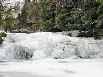 As we approached the trail to the lean-to there were a few drift over 12 inches deep. The trail up to the spring was hard to find but we made it passed the spring and climbed to the summit plateau where we made a left to head toward the tower. Again there were some drifts that were deep but for only a short distance. The sun had shown threw the clouds elevating our spirits but making the snow soft and hard to walk through. I stopped to take a few pictures of the snow and the trees and then stopped again in the evergreen tunnel. When we broke out into the tower clearing at 12:30 PM, it was sunny and I took a few shots of the tower before taking off my pack and the picnic table and preparing for a trip up the tower. Cindy elected to stay on the ground with the dog which was a good idea since the steps were very icy. As I climbed the tower, the wind really seated to pick up making me glad that the air temperature was relatively warm. I took pictures of the hills from the landing just below the cab. The skies were blue but there weren't very many clouds for contrast. I came down the tower, took a few pictures of Sheila near the base and got a drink before heading out. We walked passed the cabin and down the trail on the back side of the mountain. The snow here was more of a powder and allowed us to make great time. We did meet two young women coming up from the Millbrook trailhead but Sheila was being uncooperative so we just said "Hello" and continued on our way. BY 1:05 PM we had descended back to the main trail where we turned right to head back to the car. From this point the trail is mostly downhill and we made good time. Along the way we met two young men from Mt. Hope in Orange County. They had overnight packs and were headed to the lean-to. We stopped to talk about conditions and they mentioned the Devil's Path. They had been there recently and encountered very icy conditions. They seemed surprised that I told them exactly were they had found the most ice. I mentioned my website and later got an email from one of them. Cindy and I continued on down the trail passing the other trail junction. We arrived back at the car by 2:00 PM having covered 4.3 miles and 1240 feet of elevation gain in 3 hours. This was not our fastest trip but was still very enjoyable. On the way up the Beaverkill Road I had noticed that the Beaverkill Falls was almost completely frozen over. On the way back I parked the car along the side of the road and walked down to the falls to take some pictures. Cindy and Sheila stayed in he car. The falls were beautiful and I took several shots from different angles and different positions.
![]()
![]()
![]() On Monday, January 27th, Cindy and I decided to get out for a hike after many days of brutally low temperatures. I had been at a track meet both Friday and Saturday and was ready to get outside. As often happens, our plans were altered by a morning ambulance call. When I got home, we got dressed and headed to Frick Pond. We arrived in the parking area at about 11:30 AM and decided to hike out to Frick Pond and then see where we might go from there. My time was limited as I had to get to track practice. We both donned our Microspikes as our previous experience told us there would be ice. As I put mine on I noticed one of the links was snapped. I was annoyed as I had not used them that much and am very careful when I do. Apparently this is a common problem! This is unfortunate since the retail price of $50 should mean they last longer. As we were hiking it was snowing and blowing and the sky was overcast. I had brought the camera but doubted it would come out of the pack. When we got to the bridge, we simply continued our hike without taking break. At the next trail junction Cindy wanted to stay right around the pond but I wanted a longer experience. We stayed to the left on the Quick Lake Trail and headed for Iron Wheel Junction. We were both keeping up a quick pace but not as quick a Sheila who was darting up and down the trail as well as following some game trails! As we hiked, I began to think about what I still had to do in the afternoon. When we got to the trail junction, I decided to turn right on the Logger's Loop and forego the longer loop around Hodge Pond as this better fit my schedule. The walk along the Logger's Loop seemed long but we were soon at Times Square. I decided we would walk around the back of Frick Pond and over the wooden bridges. It didn't take us log before we were back at the Quick Lake Trail where we turned left and retraced our route back to the car. It we arrived back at the parking area a little after 1:00 PM. It had taken about a hour and 40 minutes to hike the 3.8 mile route.
On Monday, January 27th, Cindy and I decided to get out for a hike after many days of brutally low temperatures. I had been at a track meet both Friday and Saturday and was ready to get outside. As often happens, our plans were altered by a morning ambulance call. When I got home, we got dressed and headed to Frick Pond. We arrived in the parking area at about 11:30 AM and decided to hike out to Frick Pond and then see where we might go from there. My time was limited as I had to get to track practice. We both donned our Microspikes as our previous experience told us there would be ice. As I put mine on I noticed one of the links was snapped. I was annoyed as I had not used them that much and am very careful when I do. Apparently this is a common problem! This is unfortunate since the retail price of $50 should mean they last longer. As we were hiking it was snowing and blowing and the sky was overcast. I had brought the camera but doubted it would come out of the pack. When we got to the bridge, we simply continued our hike without taking break. At the next trail junction Cindy wanted to stay right around the pond but I wanted a longer experience. We stayed to the left on the Quick Lake Trail and headed for Iron Wheel Junction. We were both keeping up a quick pace but not as quick a Sheila who was darting up and down the trail as well as following some game trails! As we hiked, I began to think about what I still had to do in the afternoon. When we got to the trail junction, I decided to turn right on the Logger's Loop and forego the longer loop around Hodge Pond as this better fit my schedule. The walk along the Logger's Loop seemed long but we were soon at Times Square. I decided we would walk around the back of Frick Pond and over the wooden bridges. It didn't take us log before we were back at the Quick Lake Trail where we turned left and retraced our route back to the car. It we arrived back at the parking area a little after 1:00 PM. It had taken about a hour and 40 minutes to hike the 3.8 mile route.
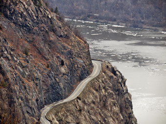
![]()
![]()
![]()
![]()
![]() On Monday, January 20th I decided to head south and east to Storm King Mountain. I had not listed this area for about a year and wanted to get back to some of the spectacular views from the area. I had avoided this area during the summer since the tick population is so high. Also, my summer was consumed by section hiking the Finger lakes Trail. On Saturday I had been at West Point for a track meet and the ice on the Hudson River was so interesting it motivated me to even more to take this hike. I was surprised that the Storm King Highway was still open but I decided this was the route I wanted to take. My plan was to park at the Stillman Spring parking area and hike a clockwise double loop over North Point and then Storm King. Unfortunately, the sunny day forecast for Monday turned out to be more of an overcast for the entire day! I tried to get started early but time seemed to slip away. The drive seemed to go quickly and we arrived at the parking area at 9:40 AM to find no other cars parked in the lot. I was a little cold when I got out of the car but fortunately did not decided to change to a heavier shirt. We crossed the road and got on the blue Howell Trail which is the backbone of the trail system in this area. The ground was frozen solid but there was little snow or ice. I was prepared with spikes in my pack since previous experience told me that ice can be a problem. In a little less than a half mile we gained a few hundred feet to the area known as Pitching Point. This is the first good lookout over the Hudson although I knew better ones were to come. We stopped so that I could take some pictures. The ice covered part of the river and was piled up along the shores. I saw the first of several trains I would see during the day on the tracks on the eastern shore. The real climb to the ridge started after Pitching Point and we did encounter a few patches of ice and some snow on the rocks. Both of these proved to be slippery but did not warrant spikes. In the next .4 miles we gained almost 550 feet over a 26% grade to near the top of the ridge. We stopped several times along the way so that I could take more pictures. Across the river I could see Little Stony Point and MounTaurus. Slightly upriver I caught glimpses of Pollopel Island, Breakneck Ridge and the Newburgh-Beacon Bridge.
On Monday, January 20th I decided to head south and east to Storm King Mountain. I had not listed this area for about a year and wanted to get back to some of the spectacular views from the area. I had avoided this area during the summer since the tick population is so high. Also, my summer was consumed by section hiking the Finger lakes Trail. On Saturday I had been at West Point for a track meet and the ice on the Hudson River was so interesting it motivated me to even more to take this hike. I was surprised that the Storm King Highway was still open but I decided this was the route I wanted to take. My plan was to park at the Stillman Spring parking area and hike a clockwise double loop over North Point and then Storm King. Unfortunately, the sunny day forecast for Monday turned out to be more of an overcast for the entire day! I tried to get started early but time seemed to slip away. The drive seemed to go quickly and we arrived at the parking area at 9:40 AM to find no other cars parked in the lot. I was a little cold when I got out of the car but fortunately did not decided to change to a heavier shirt. We crossed the road and got on the blue Howell Trail which is the backbone of the trail system in this area. The ground was frozen solid but there was little snow or ice. I was prepared with spikes in my pack since previous experience told me that ice can be a problem. In a little less than a half mile we gained a few hundred feet to the area known as Pitching Point. This is the first good lookout over the Hudson although I knew better ones were to come. We stopped so that I could take some pictures. The ice covered part of the river and was piled up along the shores. I saw the first of several trains I would see during the day on the tracks on the eastern shore. The real climb to the ridge started after Pitching Point and we did encounter a few patches of ice and some snow on the rocks. Both of these proved to be slippery but did not warrant spikes. In the next .4 miles we gained almost 550 feet over a 26% grade to near the top of the ridge. We stopped several times along the way so that I could take more pictures. Across the river I could see Little Stony Point and MounTaurus. Slightly upriver I caught glimpses of Pollopel Island, Breakneck Ridge and the Newburgh-Beacon Bridge.
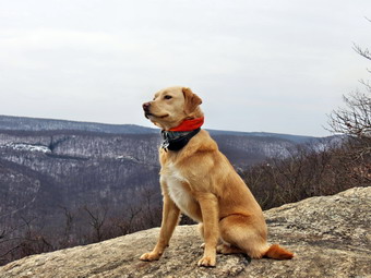 After the climb, the trail leveled some and actually descended until the final climb up to North Point. We stopped at the boulder just before the highest point. The view from this spot is to the north. I took many pictures including some of the Storm King Highway below. It always amazes me how this road hangs on the edge of the mountain as it winds its way along the eastern shore! I started to get a little cold as the wind was blowing and I was sweaty so we left North Point and continued on the Howell Trail. As we descended from North Point to the west, the trail met a woods road where we turned right to stay on the blue trail. It felt good to be hiking down and we picked up the pace considerably. The trail quickly descended into an area known as The Clove which is filled with large rocks and has a small stream to cross. As we crossed the stream, Sheila dove in and got pretty wet. I was worried she would get too cold but it did not seem to bother her. Of course, the problem with a long ascent is there is usually an ascent on the other side. Over the next .5 miles we ascended 550 feet on a 22% grade. Along the way we met two young men who we the first people we had seen all day. Near the top of the ascent the Howell Trail meets a woods road marked with white blazes. A left turn allows access to the parking area on Route 9W. We turned right and ascended a little more to a trail junction. The Howell Trail turned left here but we stayed right on the white Bypass Trail heading slightly northeast. For the next .4 miles the trail continued to ascend as we came closer to the summit of Storm King Mountain. There were several lookouts along the way but I knew that the best was just passed the junction with the Stillman Trail. When we got to the junction, we walked passed it a short distance to an open rock face which formed the lookout. We stopped and I dropped my pack so I could get out my camera and take some pictures. The day was overcast with the sky being a uniform gray. After taking some pictures to the south and east, I took a few of Sheila perched on the open rock and looking intently at the river. After completing by photographic attempts, I donned my pack and we headed back to the junction with the yellow Stillman Trail.
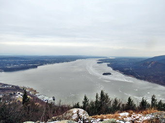 At the trail junction we turned right to take the yellow Stillman Trail over the summit of Storm King Mountain. The trail across the summit is almost flat and after the first short climb we stopped so that I could take pictures. I tried to limit the number I took since, although the view was nice, it want too different than several others along the way. As we continued to walk across the summit plateau, we met group of four people with a black and brown dog. The dog was NOT on a leash but seemed friendly enough. We exchanged greetings and then went our separate ways. As we walked I began to wonder where the Howell Trail was since I had not been this way in a long time. On a short descent we met tow young women who would be our last human encounters of the day. Soon we were at the junction with the Howell Trail and turned right to head back down toward The Clove. In just .4 miles we were back at the junction with the white Bypass trail. We continued on the Howell Trail making the sharp right to avoid walking out to Route 9W. As we descended into The Clove again, I wondered for a moment if I could easily pick up the Crossover Trail or the Stillman Spring Trail as I had missed both on the way out. As we descended about .5 miles, I easily picked up the Crossover Trail. The blazes are now painted over in gray but the trail is still obvious. I decided to continue on and in .2 miles found the white blazes of the Stillman Spring Trail on the left. We turned and continued to descend the last .6 miles and 500 feet to the car. When we arrived back at the parking area, another car was parked next to mine but no one was around. It was 1:50 Pm and we had hiked 6.3 miles in 4 hours and 10 minutes with a 2300 foot elevation gain overall. The pace was very SLOW for us but I knew that the numerous stops to take pictures was the primary culprit. I will admit that the route was hillier than I remembered and it was a good workout!
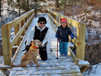
![]()
![]()
![]()
![]()
![]() On Friday, January 17th our almost three year old grandson, Bryce, was at the house. He wanted to go for a hike with his snowshoes. There wasn't enough snow for the snowshoes but we decided to head out to Frick Pond to see how far we could go. The temperature was right around freezing so he bundle him up and headed out with Sheila in the backseat to keep him company. When we arrive at just before 11;00 AM there were no other cars in the lot. We started out on the Quick Lake Trail toward Frick Pond almost immediately. Sheila was happy to be out and was running back and forth on the trail. I had packed our spikes but we decided to delay putting them on until we could assess the trail conditions. Bryce had insisted on having a pole so I shortened one and gave it to him. When we got to the register box and the woods road to Frick Pond, it was obvious that there was a lot of ice under a thin covering of snow. I took Bryce's hand to help steady him and encouraged him to walk with me on the side of the trail. We made the walk to the first trail junction in good time and turned left to head down to Frick Pond. The hill was a sheet of ice so we headed into the woods and took a short bushwhack down to the bridge. Cindy and I both put on our spikes. I took pictures of the other hikers on the bridge and some shots of the pond. We crossed the bridge and walked the trail to where the Quick Lake Trail turns left. At this point we decided to bear right and walk the trail around Frick Pond. As we hiked Bryce informed us that the trees were "coniferous" and he was right. There is a nice "tunnel" on the trail complete with several wooden walkways. There was no ice on the walkways but a thin layer of snow made them tricky. Bryce was doing well with his pole except that it kept getting caught in the spaces between the boards. Soon we were coming around the back of the pond and the trail had several places where there was open water. By the time we got to Times Square, Bryce was complaining of being a little tired. I encouraged him to keep walking and we began to talk more and sing "hiking songs". This seemed to help as we completed the loop back to the first trail junction. From that point back to the car, we both held one of Bruce's hands and let him swing over some of the wet and icy spots. We were back at the parking area by 12:30 PM. As we climbed the little bank at the end of the trail Bryce said "We made it!" Our 2.2 mile hike was most enjoyable and we hope to get out again soon.
On Friday, January 17th our almost three year old grandson, Bryce, was at the house. He wanted to go for a hike with his snowshoes. There wasn't enough snow for the snowshoes but we decided to head out to Frick Pond to see how far we could go. The temperature was right around freezing so he bundle him up and headed out with Sheila in the backseat to keep him company. When we arrive at just before 11;00 AM there were no other cars in the lot. We started out on the Quick Lake Trail toward Frick Pond almost immediately. Sheila was happy to be out and was running back and forth on the trail. I had packed our spikes but we decided to delay putting them on until we could assess the trail conditions. Bryce had insisted on having a pole so I shortened one and gave it to him. When we got to the register box and the woods road to Frick Pond, it was obvious that there was a lot of ice under a thin covering of snow. I took Bryce's hand to help steady him and encouraged him to walk with me on the side of the trail. We made the walk to the first trail junction in good time and turned left to head down to Frick Pond. The hill was a sheet of ice so we headed into the woods and took a short bushwhack down to the bridge. Cindy and I both put on our spikes. I took pictures of the other hikers on the bridge and some shots of the pond. We crossed the bridge and walked the trail to where the Quick Lake Trail turns left. At this point we decided to bear right and walk the trail around Frick Pond. As we hiked Bryce informed us that the trees were "coniferous" and he was right. There is a nice "tunnel" on the trail complete with several wooden walkways. There was no ice on the walkways but a thin layer of snow made them tricky. Bryce was doing well with his pole except that it kept getting caught in the spaces between the boards. Soon we were coming around the back of the pond and the trail had several places where there was open water. By the time we got to Times Square, Bryce was complaining of being a little tired. I encouraged him to keep walking and we began to talk more and sing "hiking songs". This seemed to help as we completed the loop back to the first trail junction. From that point back to the car, we both held one of Bruce's hands and let him swing over some of the wet and icy spots. We were back at the parking area by 12:30 PM. As we climbed the little bank at the end of the trail Bryce said "We made it!" Our 2.2 mile hike was most enjoyable and we hope to get out again soon.
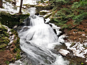
![]()
![]()
![]()
![]()
![]() On Monday, January 13th I wanted to get in a hike close to home and decided to visit Trout Pond. The area around Trout and Mud Ponds is a favorite of mine but I had not been there in some time. I didn't know what to expect as far as trail conditions and the volume of water at the falls since it rained for most of the weekend and the warm temperatures had melted all the snow in town. Cindy wanted to go and Sheila immediately knew we were going hiking. She tends to stick close to make sure I know she wants to go. By the time we left the house at around 10:40 AM the temperature was in the high 20's. As we drove up Morton Hill Road just outside of Roscoe the amount of snow on the ground started to increase. There was a lot of snow and ice where I parked along the side of Morton Hill Road near Russell Brook Road at about 11;00 AM. It appeared that Russell Brook Road was covered in ice. Before we started our hike, Cindy decided to put on her spikes while I decided to wait until I saw what the road looked like. As we started down Russell Brook Road the wisdom of Cindy's decision became obvious and I stopped almost immediately to don my spikes. The road was a sheet of ice and it was obvious no one had traveled on it in some time. Before we reached the viewpoint over the upper falls, we could hear the crashing of the water. One look showed that the rain and melting snow over the weekend has raised the level of the brook. I had to stop to take a few shots despite the fact that I have many pictures from the same spot. There was a large volume of water going over the falls and the snow on the ground created an interesting effect. We walked down to the lower parking area which was empty but completely ice covered. From there we headed down to the bridge over Russell Brook. We crossed the bridge and I decided to take some pictures of the lower falls. The trail was completely covered in ice but Sheila and I careful made our way1 down to the streambed. I took pictures of the falls and the frozen water beside it. The frozen water was almost a perfect mirror of the flowing water. After taking a few shots, we climbed back up the bank and walked out to the main trail.
On Monday, January 13th I wanted to get in a hike close to home and decided to visit Trout Pond. The area around Trout and Mud Ponds is a favorite of mine but I had not been there in some time. I didn't know what to expect as far as trail conditions and the volume of water at the falls since it rained for most of the weekend and the warm temperatures had melted all the snow in town. Cindy wanted to go and Sheila immediately knew we were going hiking. She tends to stick close to make sure I know she wants to go. By the time we left the house at around 10:40 AM the temperature was in the high 20's. As we drove up Morton Hill Road just outside of Roscoe the amount of snow on the ground started to increase. There was a lot of snow and ice where I parked along the side of Morton Hill Road near Russell Brook Road at about 11;00 AM. It appeared that Russell Brook Road was covered in ice. Before we started our hike, Cindy decided to put on her spikes while I decided to wait until I saw what the road looked like. As we started down Russell Brook Road the wisdom of Cindy's decision became obvious and I stopped almost immediately to don my spikes. The road was a sheet of ice and it was obvious no one had traveled on it in some time. Before we reached the viewpoint over the upper falls, we could hear the crashing of the water. One look showed that the rain and melting snow over the weekend has raised the level of the brook. I had to stop to take a few shots despite the fact that I have many pictures from the same spot. There was a large volume of water going over the falls and the snow on the ground created an interesting effect. We walked down to the lower parking area which was empty but completely ice covered. From there we headed down to the bridge over Russell Brook. We crossed the bridge and I decided to take some pictures of the lower falls. The trail was completely covered in ice but Sheila and I careful made our way1 down to the streambed. I took pictures of the falls and the frozen water beside it. The frozen water was almost a perfect mirror of the flowing water. After taking a few shots, we climbed back up the bank and walked out to the main trail.
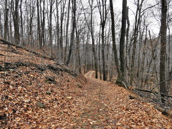 At the split in the trail we headed right to do the loop in a counterclockwise direction. There was snow and ice on the trail in some places but other spots were soft and muddy. We set a fast pace up the trail toward Trout Pond and as we approached I was surprised to see that there was ice covering most of the pond. The only open area I could see was near the spillway and the near shore. I took some pictures of the scenery with the ice on the pond but the sky was totally overcast which was not ideal. I threw a stick out onto the ice for Sheila to retrieve and took pictures as she returned with it. We headed back to the main trail and walked up to the inlet end of the pond. The trail had some very wet spots along the way with pools of water in places. We walked to the upper end of the pond and found no one at the lean-tos. I took a few pictures of the pond and we then continued over the bridge and up the trail toward Cherry Ridge. As we began to ascend, the trail began to be covered in snow and ice with more in the surrounding woods. This area also had a more northerly and westerly exposure. The snow and ice continued to the top of the rise and then dissipated some on the other side. We continued to run into some areas with snow but also walked around some water and mud. Soon we were at the junction with the snowmobile trail that runs past Mud Pond. We turned left and found more ice on the snowmobile trail as we climbed a little before descending. The descent was almost completely free of snow and looked like late fall or early spring. Several places were muddy and others had flowing water. We were soon back at the trail junction near the register box. From there we walked back out to the lower parking area and then up the road to the car. The walk up the icy road actually seemed easier than the walk down. We were back at the car at 1:50 PM having covered 5.6 miles in 2 hours and 40 minutes.
On Thursday, January 8th, I decided I needed to get out and take a short walk since the temperature was finally in the double digits. The minus 20 degree wind-chill that had been present for the last two days were gone and the sun was even out! When Lisa called and asked if I wanted to do a short hike, I readily agreed. She had to meet with a sales rep in the morning. She called me from across the street at about 12:30 PM and I quickly got dressed and Sheila and I walked across the street to meet her. We decided that we might need spikes but that snowshoes, unfortunately, were not necessary. We started up the hill by the cemetery and then turn left into the wood at the top of the hill. I had decided not to bring along my packs, camera or GPS. I just wanted to concentrate on having a good time without the "responsibilities" of mapping or taking pictures. There was little or no snow in the woods but it was icy in places. Lisa elected to don her spikes while I kept mine in my pocket. We walked and talked as Sheila explored all the animal trails along the way. After ascending the second hill, I checked my watch and decided we should make the turn to complete the loop and head back. I had indoor track practice at 3:00 PM for the first time in over two weeks. We were back at just before 2:00 PM after king around 3 miles. At times my face felt a little cold but otherwise we had a great time.
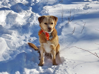
![]()
![]()
![]()
![]() On Saturday, January 4th, I decided to finally get out on my first hike of 2014! The weather had been challenging to say the least with snow covered roads and windchills well below Saturday Saturday morning the temperature was still around zero so I decided to wait until a little later in the day to start a hike. I was concerned that Sheila might not be able to handle the extremely cold weather. We left Livingston Manor and headed out the Debruce Road a little before 1:00 PM. I was surprised that the roads were cleared all the way to the end of Beech Mountain Road and that the parking areas were plowed. I was equally surprised to find another car in the lot! From the tracks, it seemed like a group of three or four people had started up the Flynn Trail on snowshoes. I decided to follow them so Sheila and I crossed the road at 1:05 PM and started up the Flynn Trail. The temperature had risen all the way up to 18 degrees which seemed almost warm. I had chosen to use my Crescent Moon Gold snowshoes which are good on flat and rolling terrain. They have some of the best bindings and a teardrop shape. I had put on a Patagonia Capilene 1 under my Icebreaker 320 top but soon realized that I was overdressed! The first part of the Flynn Trail through the woods is narrow and I was having a little trouble not overlapping the wider snowshoes. Once we made the right turn into the woods road the going was easier. I was surprised to find that the group ahead of us was walking abreast rather than single file. I assumed that they must be novices since anyone experienced at snowshoeing would know that single file is the best way to break trail! Before we had gone half a mile I had stopped to open some zippers and dump some heat. The walk with snowshoes is definitely more of a workout than without. We continued up the Flynn Trail until we were at the junction with the Big Rock Trail. It had taken just about an hour to walk the 1.7 miles from the parking area.
On Saturday, January 4th, I decided to finally get out on my first hike of 2014! The weather had been challenging to say the least with snow covered roads and windchills well below Saturday Saturday morning the temperature was still around zero so I decided to wait until a little later in the day to start a hike. I was concerned that Sheila might not be able to handle the extremely cold weather. We left Livingston Manor and headed out the Debruce Road a little before 1:00 PM. I was surprised that the roads were cleared all the way to the end of Beech Mountain Road and that the parking areas were plowed. I was equally surprised to find another car in the lot! From the tracks, it seemed like a group of three or four people had started up the Flynn Trail on snowshoes. I decided to follow them so Sheila and I crossed the road at 1:05 PM and started up the Flynn Trail. The temperature had risen all the way up to 18 degrees which seemed almost warm. I had chosen to use my Crescent Moon Gold snowshoes which are good on flat and rolling terrain. They have some of the best bindings and a teardrop shape. I had put on a Patagonia Capilene 1 under my Icebreaker 320 top but soon realized that I was overdressed! The first part of the Flynn Trail through the woods is narrow and I was having a little trouble not overlapping the wider snowshoes. Once we made the right turn into the woods road the going was easier. I was surprised to find that the group ahead of us was walking abreast rather than single file. I assumed that they must be novices since anyone experienced at snowshoeing would know that single file is the best way to break trail! Before we had gone half a mile I had stopped to open some zippers and dump some heat. The walk with snowshoes is definitely more of a workout than without. We continued up the Flynn Trail until we were at the junction with the Big Rock Trail. It had taken just about an hour to walk the 1.7 miles from the parking area.
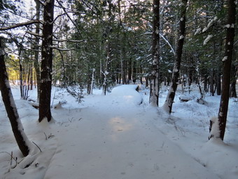 At the trail junction we stopped so that I could take some pictures of the snowy trails. The group had gone straight ahead to Hodge Pond so I decided to turn left and go down the Big Rock trail to Times Square. I like descending on snowshoes since, at times, you can almost ski down. The trail had been recently broken by a snowmobile which I could hear in the distance. The trip down the Big Rock Trail went quickly and we were soon approaching Times Square. Sheila was having a great time and did not seem to be bothered in any way by the snow or temperature. She kept going off the snowmobile trail to follow animals tracks. As we neared Times Square, we could hear a snowmobile approaching. I was surprised that the machine was coming from the left on he Logger's Loop trail from Frick Pond. This trail SHOULD be off-limits to snowmobiles. A young rider made the turn up the Big Rock Trail and waved to us as he passed. I wondered if he knew he was violating the rules of the trail or whether he just didn't bother to find out what they were! We continued straight ahead at Times square to go around the back of Frick Pond. This was the first unbroken snow of the day and it was more challenging to walk through the fresh snow. As we approached the bridges and wooden walkways, the views of the pond were pretty. I stopped and tome some pictures including some of the water running under the ice. I also stopped to take some pictures on the wooden walkways where the snow was deeper than anywhere else. We continued to walk until we her at the junction with the Quick Lake Trail. Here we turned left and headed for the bridge across the outlet of Frick Pond. We stopped briefly at the bridge and I took a few pictures before heading back to the parking area. As we were finishing our hike, the group that had started ahead of us showed up. They had hiked out to Hodge Pond and back on the Flynn Trail. We were back by 3:10 PM having covered 4 miles in 2 hours and 5 minutes.
![]()
![]()
![]() On Tuesday, December 31st, I decided I wanted get out and do a hike on the last day of 2013. The temperature in the morning in Livingston Manor was just 12 degrees so I was in no hurry to get started. I thought I might try to get to Balsam Lake Mountain to see if the recent rain had fallen as snow there. By the time I was ready to head out some snow was falling and I knew the Beaverkill Road would be nearly impassable with the recent icing conditions. I decided to head to Trout Pond as it is close and I had not been there too recently. Brad and Krista were going to head back to Pennsylvania and I wanted to be home to see them off. I drove through Roscoe and turned left onto Morton Hill Road. A soon as I made the turn it was clear that the road had not been plowed or sanded. As I gained elevation the snowfall was harder and the road worse! I crested the hill and started down the other side toward the junction with Russell Brook Road. I tried braking to see what the conditions were like under the snow. My car began to brake intermittently and the traction control system kicked in to eventually slow me down. I turned around at Russell Brook Road and parked on the side of Morton Hill Road at about 11:$% AM. I got out my gear and joined Sheila who was more than ready to start. I had not brought snowshoes but did have my spikes in my pack. The road was icy but the ice was rough in most places and there was a ridge of snow down the middle. A few sets of vehicle tracks were present and I could see one set of footprints. We ere soon at the viewpoint over the upper falls. There was a large volume of crystal clear water flowing over the falls but as my main goal was a quick "fitness" hike, we continue on down to the lower parking area. From the parking area we followed the road down to the bridge over Russell Brook. I decided not to go to the lower falls so we continued on the road and turned left just passed the register box. I wanted to climb the steeper hill on the way out and descend he more gentle slope from Trout pond on the way back. The ascent went well for the most part and I was able to avoid the slipperier areas. Putting on the spikes would have been the smarter thing to do but for some reason I avoided this. By 12:25 PM we were near Mud Pond and turned right to take the trail over Cherry Ridge to Trout Pond. We continued to climb but the trail had less ice and more crunchy snow. At 12:50 Pm we had walked2.7 miles and climbed 830 feet to the highest point ion the hike at 2544 feet. From here the hike was all downhill or flat until the final ascent back to the car from the lower parking area. At 3.5 miles we crossed the new bridge over the inlet to the pond. I had thought that we might stop so that I could take pictures of the pond but the snow was falling so hard it obscured any good views. We walked down the east side of the pond. Along the way there were two large blowdowns that blocked the road. The trees seemed to be the victim off higher water levels in the pond and some high winds. We passed by the outlet to the pond and started down the gentler slope to the register box to complete the loop. This part of the road was covered in much smoother and slipperier ice. I had to walk carefully and use the s the of the trail to avoid falling. At 1:35 PM we were back at Russell Brook and I decided to skip the falls as I wanted to get back home before Krista and Brad left. The final hike up to the car was uneventful. As we walked to the car it was obvious on one including snowplows had been on the road. We were back at the car by 1:55 PM having covered 5.4 miles in 2 hours and 10 minutes with an elevation gain of about 1150 feet.
On Tuesday, December 31st, I decided I wanted get out and do a hike on the last day of 2013. The temperature in the morning in Livingston Manor was just 12 degrees so I was in no hurry to get started. I thought I might try to get to Balsam Lake Mountain to see if the recent rain had fallen as snow there. By the time I was ready to head out some snow was falling and I knew the Beaverkill Road would be nearly impassable with the recent icing conditions. I decided to head to Trout Pond as it is close and I had not been there too recently. Brad and Krista were going to head back to Pennsylvania and I wanted to be home to see them off. I drove through Roscoe and turned left onto Morton Hill Road. A soon as I made the turn it was clear that the road had not been plowed or sanded. As I gained elevation the snowfall was harder and the road worse! I crested the hill and started down the other side toward the junction with Russell Brook Road. I tried braking to see what the conditions were like under the snow. My car began to brake intermittently and the traction control system kicked in to eventually slow me down. I turned around at Russell Brook Road and parked on the side of Morton Hill Road at about 11:$% AM. I got out my gear and joined Sheila who was more than ready to start. I had not brought snowshoes but did have my spikes in my pack. The road was icy but the ice was rough in most places and there was a ridge of snow down the middle. A few sets of vehicle tracks were present and I could see one set of footprints. We ere soon at the viewpoint over the upper falls. There was a large volume of crystal clear water flowing over the falls but as my main goal was a quick "fitness" hike, we continue on down to the lower parking area. From the parking area we followed the road down to the bridge over Russell Brook. I decided not to go to the lower falls so we continued on the road and turned left just passed the register box. I wanted to climb the steeper hill on the way out and descend he more gentle slope from Trout pond on the way back. The ascent went well for the most part and I was able to avoid the slipperier areas. Putting on the spikes would have been the smarter thing to do but for some reason I avoided this. By 12:25 PM we were near Mud Pond and turned right to take the trail over Cherry Ridge to Trout Pond. We continued to climb but the trail had less ice and more crunchy snow. At 12:50 Pm we had walked2.7 miles and climbed 830 feet to the highest point ion the hike at 2544 feet. From here the hike was all downhill or flat until the final ascent back to the car from the lower parking area. At 3.5 miles we crossed the new bridge over the inlet to the pond. I had thought that we might stop so that I could take pictures of the pond but the snow was falling so hard it obscured any good views. We walked down the east side of the pond. Along the way there were two large blowdowns that blocked the road. The trees seemed to be the victim off higher water levels in the pond and some high winds. We passed by the outlet to the pond and started down the gentler slope to the register box to complete the loop. This part of the road was covered in much smoother and slipperier ice. I had to walk carefully and use the s the of the trail to avoid falling. At 1:35 PM we were back at Russell Brook and I decided to skip the falls as I wanted to get back home before Krista and Brad left. The final hike up to the car was uneventful. As we walked to the car it was obvious on one including snowplows had been on the road. We were back at the car by 1:55 PM having covered 5.4 miles in 2 hours and 10 minutes with an elevation gain of about 1150 feet.
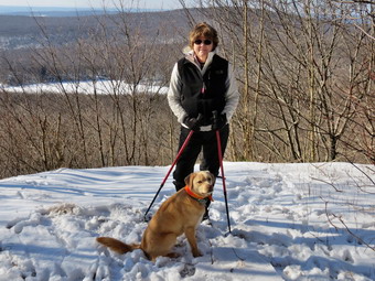
![]()
![]()
![]()
![]()
![]() On Saturday, Dec28th, I asked Cindy if she would like to hike and she said "Yes". We decided to take her to the Hodge Pond Lookout to see what the view looked like without the leaves on the trees. I had some errands I had to do in the morning so we didn't get started until after 10:30 AM which was OK since the temperature by that time had risen into the 20's. There had been some light snow and we weren't sure whether or not we would need snowshoes. We got our gear including snowshoes into them car, put Sheila in the backseat and headed off to the trailhead. We arrived at 11:00 AM and it was obvious we would not need the snowshoes. We walked across the road and started up the Flynn Trail with an air temperature of 28 degrees and a light wind blowing. The skies were blue with a only a few white clouds and some sun. The Flynn Trail is uphill all the way for the first 1.7 miles to the Big Rock Junction but we set a fast pace. Along the way I though about visiting the meadow on the right of the trail and whether or not we would return by the same route. We continued through the junction to the point where the Flynn Trail heads downhill to Hodge Pond. Here we turned to the right on a woods road and walked along the "high road" to the junction of some roads above the pond. At this junction a road turns left to go down to the pond. Just a little further on the road splits with the left fork passing by the old Beech Mountain Boy Scout Camp and ending up on Shin Creek Road in Lew Beach. I thought about visiting the building that we could easily see through the trees but decided to continue on to our destination first. We continued straight ahead to climb the road up the hill. The road was a little steeper than I remembered but we kept our pace. There was an increasing amount of snow as we climbed but nowhere did we need the snowshoes.
On Saturday, Dec28th, I asked Cindy if she would like to hike and she said "Yes". We decided to take her to the Hodge Pond Lookout to see what the view looked like without the leaves on the trees. I had some errands I had to do in the morning so we didn't get started until after 10:30 AM which was OK since the temperature by that time had risen into the 20's. There had been some light snow and we weren't sure whether or not we would need snowshoes. We got our gear including snowshoes into them car, put Sheila in the backseat and headed off to the trailhead. We arrived at 11:00 AM and it was obvious we would not need the snowshoes. We walked across the road and started up the Flynn Trail with an air temperature of 28 degrees and a light wind blowing. The skies were blue with a only a few white clouds and some sun. The Flynn Trail is uphill all the way for the first 1.7 miles to the Big Rock Junction but we set a fast pace. Along the way I though about visiting the meadow on the right of the trail and whether or not we would return by the same route. We continued through the junction to the point where the Flynn Trail heads downhill to Hodge Pond. Here we turned to the right on a woods road and walked along the "high road" to the junction of some roads above the pond. At this junction a road turns left to go down to the pond. Just a little further on the road splits with the left fork passing by the old Beech Mountain Boy Scout Camp and ending up on Shin Creek Road in Lew Beach. I thought about visiting the building that we could easily see through the trees but decided to continue on to our destination first. We continued straight ahead to climb the road up the hill. The road was a little steeper than I remembered but we kept our pace. There was an increasing amount of snow as we climbed but nowhere did we need the snowshoes.
 There were places where there was ice under the snow and I thought about getting out my spikes several times. We solved the problem by walking carefully and keeping to the sides of the trail. We stopped briefly as the trail leveled at the old quarry and then continued our hike. We passed by a spring house on the right and at 2.6 miles turned right onto a another woods road. This turn occurred where the main road turned sharply to the left. The trail we turned onto was more well defined than I remembered and the tracks of an ATV were faintly visible. After a slight incline, we walked to 2.9 miles over flat ground to the Hodge Pond Lookout. I dropped my pack and took some pictures of the pond below and the hills in the distance. The brush had grown up in front of the lookout so the view was limited. I asked Cindy to pose with Sheila on the rock that forms the lookout and I took several pictures. We grabbed a drink and a bar for lunch and then headed back down the hill. The trip down was a little more exciting than the trip up. The slippery spots seemed much slipperier on the way down! When we got to the base of the hill at the junction of the roads, we walked over what is left of the buildings from the Boy Scout camp. I took some pictures before we headed back to the woods road. We walked out to the Flynn Trail and turned left and were soon at the junction with the Big Rock Trail. I had though about returning this way but we decided to continue on down the Flynn Trail. When we got to the path to the right to the meadow, we decided to make a visit and walked the short path up to the clearing. Snow covered the meadow but there was really nothing spectacular about the photographic opportunities as there were no clouds in the sky. I took a few pictures and we walked back out to the Flynn Trail. The rest of the hike went quickly and I noticed how warm I was even going downhill. The sun had come out and the temperature was almost 10 degrees warmer than when we had started. I checked the GPS when we arrived back at the car and found we had hiked 6 miles in 2 hours and 45 minutes with about 1200 feet of elevation gain.
![]()
![]()
![]()
![]()
![]() On Thursday, December 26th, I decided I wanted to hike along Black Bear Road near Round Pond despite the unexpected snow that was falling persistently! December had been a bad month for hiking with personal commitments and some poor weather. Brad and Krista were home for Christmas and Brad decided to take Pierce, their year old lab mix, with us on the hike which I thought was a good idea. Sheila and Pierce get along well and I thought they would both like to get out of the house. I chose Black Bear Road since it was the only piece he the Finer Lakes Trail that I had not hiked between Marathon and Table Mountain. In June 2012 I had joined a group hike from Black Bear Road to the trail's terminus on the Table Mountain Trail. I had also hiked from the end of Black Bear Road to Tunis Pond. Brad and I got our gear and the dogs in the car a little after 10:00 Am and started for the trailhead parking area. The roads were barely touched with only a little plowing done and very little sanding. As we headed out the Debruce Road, it was obvious only a few vehicles had been on the road. At the turnoff for Mongaup Pond any plowing that had been done ended and we were on our own. The Lancer with all-wheel drive and the Blizzak tires is very good in the snow. We made it to Black Bear Road and turned left and drove up the hill to the parking area. There appeared to be one set of tire tracks on the road but they were completely covered in snow. I parked in the lot and we were ready to go by 10:45 AM. The snow was still coming down and there was a little wind. I questioned by choice of wearing only a light Icebreaker shirt under my Mammut Hoody! Bard kept Pierce on his leash since he is not accustomed to hiking in strange areas. As we started out on the road, it was obvious we would have to watch our footing as there was ice under the snow in pots. I had brought spikes but didn't think it necessary to put them on. I had never walked the road and hadn't paid much attention as I drove its length. The entire hike out was uphill for 2.8 miles. The elevation gain was only 640 feet so it was never steep. I thought it would make a nice snowshoe after a greater snowfall especially if they plows stayed away.
On Thursday, December 26th, I decided I wanted to hike along Black Bear Road near Round Pond despite the unexpected snow that was falling persistently! December had been a bad month for hiking with personal commitments and some poor weather. Brad and Krista were home for Christmas and Brad decided to take Pierce, their year old lab mix, with us on the hike which I thought was a good idea. Sheila and Pierce get along well and I thought they would both like to get out of the house. I chose Black Bear Road since it was the only piece he the Finer Lakes Trail that I had not hiked between Marathon and Table Mountain. In June 2012 I had joined a group hike from Black Bear Road to the trail's terminus on the Table Mountain Trail. I had also hiked from the end of Black Bear Road to Tunis Pond. Brad and I got our gear and the dogs in the car a little after 10:00 Am and started for the trailhead parking area. The roads were barely touched with only a little plowing done and very little sanding. As we headed out the Debruce Road, it was obvious only a few vehicles had been on the road. At the turnoff for Mongaup Pond any plowing that had been done ended and we were on our own. The Lancer with all-wheel drive and the Blizzak tires is very good in the snow. We made it to Black Bear Road and turned left and drove up the hill to the parking area. There appeared to be one set of tire tracks on the road but they were completely covered in snow. I parked in the lot and we were ready to go by 10:45 AM. The snow was still coming down and there was a little wind. I questioned by choice of wearing only a light Icebreaker shirt under my Mammut Hoody! Bard kept Pierce on his leash since he is not accustomed to hiking in strange areas. As we started out on the road, it was obvious we would have to watch our footing as there was ice under the snow in pots. I had brought spikes but didn't think it necessary to put them on. I had never walked the road and hadn't paid much attention as I drove its length. The entire hike out was uphill for 2.8 miles. The elevation gain was only 640 feet so it was never steep. I thought it would make a nice snowshoe after a greater snowfall especially if they plows stayed away.
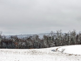 The snow continued to fall for the first mile or so and then let up. When I looked down at Sheila, she was again missing her blaze orange bandana! I did not notice when it had come off and decided to look for it on the way back. When we reached Black Bear Hunting camp, the first of many on the road, I stopped to take a few pictures. I knew I would get mixed results because of the snow that was falling around us again and the heavier snow on the surrounding hills. We walked and talked as we passed some hunting camps that looked nicer than some homes around Livingston Manor! Soon we were starting up the last hill before the end of the road. We walked to the end of the road and then turned around. A "Seasonal Maintenance" Sign caught my eye. As far as I know, there is NO MAINTENANCE on the part of the road passed the sign! I took some pictures of the High Falls Ridge which was obscured by the snow and then we started back. Since the out was all uphill, the back was all downhill. We were back in he parking area by 12:50 PM having covered 5.7 miles in just over 2 hours.