
What You Missed
Winter 2005-2006
Winter 2005-2006
![]()
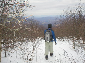
![]() On Saturday, March 18th I decided to do a longer hike since
I knew it would be the last hike of the winter. I decided to stay close to home and do the hike
I had done the first thing last summer. I headed out passed the Frost Valley YMCA Camp on Route 47.
I has a feeling as I was driving that I would find at least one other hiker. Last summer I met
Scott Lane, the Can Man, when he was replacing the canister that had been destroyed on Fir. I
thought he might be doing can maintenance as the season were changing. I was right! His truck
was in the Biscuit Brook parking area and he was signed in at the register. I headed up the trail
trying to guess whether he would do Fir or Big Indian first. I knew I couldn't catch up with him
but thought that if I made the right choice we might cross paths. I chose to do Big Indian
first thinking he would do Fir. Right again! As I approached the canister there was Scott with
Michelle. They had just bushwhacked in from Fir along the Catskill Divide. I was pretty tired since
the trail is in poor condition and it is a little longer with more elevation changes than I remember!
Scott encouraged me to follow their trail and I did. I lost their footprints several times but
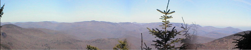
just stayed on the Divide. The Divide is relatively narrow in some spots with steep descents on both
sides. The views were nice and would be even better if there were some true look outs. As I
approached Fir I lost the footprints I had been following and had to wander around a little until I
found the canister. My GPS decided at this moment to be obstinate. At one point it had me at an
elevation of over 8000' in another part of the world! I'm glad I had my maps, compass, the sun and my
common sense. I took a southwesterly route off Fir and connected with Scott and Michelle's tracks
several times. I came down some of the steeper parts of Fir until I was just above Biscuit Brook. I
parallelled the brook until I could pick up the trail back to the parking area. I avoided the water
crossing of Biscuit Brook that had been tricky on the way out. About ten miles in 6 hours including
several stops and the typical "wandering" of bushwhacking.
On Saturday, March 18th I decided to do a longer hike since
I knew it would be the last hike of the winter. I decided to stay close to home and do the hike
I had done the first thing last summer. I headed out passed the Frost Valley YMCA Camp on Route 47.
I has a feeling as I was driving that I would find at least one other hiker. Last summer I met
Scott Lane, the Can Man, when he was replacing the canister that had been destroyed on Fir. I
thought he might be doing can maintenance as the season were changing. I was right! His truck
was in the Biscuit Brook parking area and he was signed in at the register. I headed up the trail
trying to guess whether he would do Fir or Big Indian first. I knew I couldn't catch up with him
but thought that if I made the right choice we might cross paths. I chose to do Big Indian
first thinking he would do Fir. Right again! As I approached the canister there was Scott with
Michelle. They had just bushwhacked in from Fir along the Catskill Divide. I was pretty tired since
the trail is in poor condition and it is a little longer with more elevation changes than I remember!
Scott encouraged me to follow their trail and I did. I lost their footprints several times but
just stayed on the Divide. The Divide is relatively narrow in some spots with steep descents on both
sides. The views were nice and would be even better if there were some true look outs. As I
approached Fir I lost the footprints I had been following and had to wander around a little until I
found the canister. My GPS decided at this moment to be obstinate. At one point it had me at an
elevation of over 8000' in another part of the world! I'm glad I had my maps, compass, the sun and my
common sense. I took a southwesterly route off Fir and connected with Scott and Michelle's tracks
several times. I came down some of the steeper parts of Fir until I was just above Biscuit Brook. I
parallelled the brook until I could pick up the trail back to the parking area. I avoided the water
crossing of Biscuit Brook that had been tricky on the way out. About ten miles in 6 hours including
several stops and the typical "wandering" of bushwhacking.
![]()
![]() On Sunday, March 5th the weather was much milder with
temperatures in the mid 30's and almost no wind. I chose to climb Balsam Lake Mt as it is close
and a rather quick hike. As I drove up the Beaverkill Road I noticed the depth of snow increasing.
The parking area was not plowed an there was at least six inches of snow on the ground. I chose NOT
to take my snowshoes since I intended to ascend and descend the close, steeper trail. I hoped I had
made the right decision. WARNING: There was 13 inches of snow on this mountain
in October. There will probably be as much in April. Plan accordingly! There was only one
other name in the register for Sunday and no names for the preceding week. As I hiked up to the
turnoff, I met the other hiker. He was discouraged since he had tried snow shoeing the "other"
trail which is not as steep. He got about 3/4 of the way up and turned around due to 6 foot drifts!
I was even more convinced to hike the steeper trail until I got to the turnoff and saw NO FOOTPRINTS.
As I ascended the snow got deeper averaging between 8 and 12 inches. There didn't seem to be much ice
anywhere but I was cautious anyway. I was tired from the hike the day before but a couple of shorts
stops allowed me to press on. After clearing the area near the spring, I thought the rest of the way
would be easy. From the top of that trail to the Tower were drifts of snow that consistently reached my
knees although never got quite up to my hips! I kept pushing on until I reached the tower. The steps
were icy but the views from the top were worth it. On the way down I used by boots like VERY short
skis. There were snowshoe tracks at the summit near the tower. The other hiker had made it through the
deep drifts on the other trail! Later, I learned from VFTT that I missed Ralph Ryndak by minutes.
I was a little concerned about the steepest parts of the trail but I had no problems. I was up
and down in just over two hours including the stop at the top!
On Sunday, March 5th the weather was much milder with
temperatures in the mid 30's and almost no wind. I chose to climb Balsam Lake Mt as it is close
and a rather quick hike. As I drove up the Beaverkill Road I noticed the depth of snow increasing.
The parking area was not plowed an there was at least six inches of snow on the ground. I chose NOT
to take my snowshoes since I intended to ascend and descend the close, steeper trail. I hoped I had
made the right decision. WARNING: There was 13 inches of snow on this mountain
in October. There will probably be as much in April. Plan accordingly! There was only one
other name in the register for Sunday and no names for the preceding week. As I hiked up to the
turnoff, I met the other hiker. He was discouraged since he had tried snow shoeing the "other"
trail which is not as steep. He got about 3/4 of the way up and turned around due to 6 foot drifts!
I was even more convinced to hike the steeper trail until I got to the turnoff and saw NO FOOTPRINTS.
As I ascended the snow got deeper averaging between 8 and 12 inches. There didn't seem to be much ice
anywhere but I was cautious anyway. I was tired from the hike the day before but a couple of shorts
stops allowed me to press on. After clearing the area near the spring, I thought the rest of the way
would be easy. From the top of that trail to the Tower were drifts of snow that consistently reached my
knees although never got quite up to my hips! I kept pushing on until I reached the tower. The steps
were icy but the views from the top were worth it. On the way down I used by boots like VERY short
skis. There were snowshoe tracks at the summit near the tower. The other hiker had made it through the
deep drifts on the other trail! Later, I learned from VFTT that I missed Ralph Ryndak by minutes.
I was a little concerned about the steepest parts of the trail but I had no problems. I was up
and down in just over two hours including the stop at the top!
![]()
![]() On Saturday, March 4th I decided I needed to get out despite
the 20 mph winds driving the wind chill to just above 0. No one else seemed to share my enthusiasm so
I headed out by myself. I wanted to go somewhere fairly close that had a protected trail so I chose
Giant Ledge and Panther Mountain. I would rather have done a peak that I had not hiked this winter
but those were further away. I parked a the hairpin on Route 47 and hiked to the register and signed in.
It didn't seem that cold. There was about 3 inches of snow on the trail. After a short distance, it
became clear that the ice underneath the snow would be the real problem! Within the first mile I met
two young men relaxing by the trail. These were the first people I met out of 18 hikers I saw during
the day. One large ice flow on the way up to the Ledges required some bushwhacking to negotiate my way
around it. I reached the Ledges and the views were less than spectacular. All the other peaks were
obscured by a haze or snow showers. I continued on toward the Col between the Ledges and Panther. Here
I met a group of 3 adults and 6 children. They were all experienced hikers including a 7 1/2 year old
girl working on her 14th peak! I hiked with them for a while. Several patches of ice made the descent
into the col interesting. The climb up Panther wasn't bad although the snow got deeper. On my way up
I met a mother and her two daughters who were intending to hike Balsam Mt in the same day to complete
their four winter peaks. At the lookout at the top of Panther the views were better but the wind was
blowing. I ate, dark and quickly turned around. On the way down I caught up with two hikers I had met
on the way up. There company on the way down made the descent seem very fast. I barebooted the whole trip
and think it was the easiest way to go. Crampons would have been nice in some spots. I carry all this
gear and never seem to use it!
On Saturday, March 4th I decided I needed to get out despite
the 20 mph winds driving the wind chill to just above 0. No one else seemed to share my enthusiasm so
I headed out by myself. I wanted to go somewhere fairly close that had a protected trail so I chose
Giant Ledge and Panther Mountain. I would rather have done a peak that I had not hiked this winter
but those were further away. I parked a the hairpin on Route 47 and hiked to the register and signed in.
It didn't seem that cold. There was about 3 inches of snow on the trail. After a short distance, it
became clear that the ice underneath the snow would be the real problem! Within the first mile I met
two young men relaxing by the trail. These were the first people I met out of 18 hikers I saw during
the day. One large ice flow on the way up to the Ledges required some bushwhacking to negotiate my way
around it. I reached the Ledges and the views were less than spectacular. All the other peaks were
obscured by a haze or snow showers. I continued on toward the Col between the Ledges and Panther. Here
I met a group of 3 adults and 6 children. They were all experienced hikers including a 7 1/2 year old
girl working on her 14th peak! I hiked with them for a while. Several patches of ice made the descent
into the col interesting. The climb up Panther wasn't bad although the snow got deeper. On my way up
I met a mother and her two daughters who were intending to hike Balsam Mt in the same day to complete
their four winter peaks. At the lookout at the top of Panther the views were better but the wind was
blowing. I ate, dark and quickly turned around. On the way down I caught up with two hikers I had met
on the way up. There company on the way down made the descent seem very fast. I barebooted the whole trip
and think it was the easiest way to go. Crampons would have been nice in some spots. I carry all this
gear and never seem to use it!
On Saturday, February 25th I headed for Woodland Valley with my wife, Kevin Ferguson and his dog, Rocky. Our intention was to hike Wittenberg and Cornell and then return by the same route. There was little snow at the base of the mountain and the skies were clear. The weather was actually warmer than I thought it would be and I noted that another group had signed into the trail register with the same intentions that we had. This hike is strenuous in summer due to the fact that Woodland Valley is low and The mountain isn't. As we ascended there were periods of sun and then snow squalls. Just below 3000' the depth of snow increased and as did the amount of ice. At around 3100' to 3200' we ran into a few small snow drifts and LOTS of ice. Of course, the ice was on the steepest part of the trail. I had my crampons in my pack and I had carried along my poles. Unfortunately, my wife only had Yaks and Kevin was barebooting. Kevin and I scrambled up the ice flow and he was elated because he thought we were near the top. I informed him that we had over 500' feet of vertical climb to go just to make it up Wittenberg. At this point we decided to turn back. I was disappointed that we did not summit but it was the right decision. The hike was a good workout for all and took the better part of 5 hours. The other group hiked through to route 47 and used a car shuttle to get back to Woodland Valley.
![]()
![]() On Saturday, February 11th I decided to hike to Hunter Mountain
from the Spruceton parking area, a route I had not taken before. I parked just after 10 and met a group
going up Rusk. I headed out along Hunter Brook and through the hairpin turn on the trail. There was
only a dusting of snow and this trail is wide and well kept. The trail is also marked for horseback riding
but I didn't see any horses. The sign at the turn up the mountain indicates an 1100' ascent over 1.7 miles.
The trail does get steeper and it was MUCH icier. A fresh dusting of powder hid many of the iciest spots
making the ascent "interesting". I was the first human up the trail since the last light snowfall but I
followed the tracks of three dogs from the parking area. Their paw prints revealed the ice under the snow
and, in most cases, I followed their lead. Just below the spring I encountered some MAJOR ice flows. They
were beautiful but impossible to get over. I went off the trail and bypassed the flows. Some areas of the
trail near the spring had running water! I stopped just above the spring at a nice lookout that afforded
views of Westkill and Rusk and some of the peaks beyond. The trail is still marked for horses at this
point and a "hitching post" is provided. The dusting of snow grew to several inches and the ice
underneath got worse the higher I climbed. I stubbornly (stupidly!) refused to put on the Yaks or crampons
I had in the pack. Slipping and sliding I made it to the top in under two hours. The trail is marked for
horses all the way to the top! I have NEVER been on Hunter when I could get a good view from the tower.
The weather was cloudy and overcast, so much so that I decided not to climb the tower. A few more hikers
arrived on the summit from the Becker Hollow trail. They were all wearing crampons and using poles.
They said the steep incline and ice made the gear absolutely
necessary. As I got ready to leave, the sun came out and I quickly ascended the tower. Most of the
valleys around were clearly visible but most of the peaks were still shrouded. I headed back down still
without anything but bare boots on my feet. I regretted this several times but not enough to stop and do
the right thing! I had intended to hike out to the Colonel's Chair but though better of it. I had missed
the lean-to on the way up and wanted to stop on the way down. I couldn't find a sign or the lean-to! I
did spot a pile of logs and metal brackets. Was this the lean-to? After getting by the ice flows, the hike
down was uneventful. Hiking down the wide trail I looked up a the imposing figure of Westkill to my right.
It was a great day!
On Saturday, February 11th I decided to hike to Hunter Mountain
from the Spruceton parking area, a route I had not taken before. I parked just after 10 and met a group
going up Rusk. I headed out along Hunter Brook and through the hairpin turn on the trail. There was
only a dusting of snow and this trail is wide and well kept. The trail is also marked for horseback riding
but I didn't see any horses. The sign at the turn up the mountain indicates an 1100' ascent over 1.7 miles.
The trail does get steeper and it was MUCH icier. A fresh dusting of powder hid many of the iciest spots
making the ascent "interesting". I was the first human up the trail since the last light snowfall but I
followed the tracks of three dogs from the parking area. Their paw prints revealed the ice under the snow
and, in most cases, I followed their lead. Just below the spring I encountered some MAJOR ice flows. They
were beautiful but impossible to get over. I went off the trail and bypassed the flows. Some areas of the
trail near the spring had running water! I stopped just above the spring at a nice lookout that afforded
views of Westkill and Rusk and some of the peaks beyond. The trail is still marked for horses at this
point and a "hitching post" is provided. The dusting of snow grew to several inches and the ice
underneath got worse the higher I climbed. I stubbornly (stupidly!) refused to put on the Yaks or crampons
I had in the pack. Slipping and sliding I made it to the top in under two hours. The trail is marked for
horses all the way to the top! I have NEVER been on Hunter when I could get a good view from the tower.
The weather was cloudy and overcast, so much so that I decided not to climb the tower. A few more hikers
arrived on the summit from the Becker Hollow trail. They were all wearing crampons and using poles.
They said the steep incline and ice made the gear absolutely
necessary. As I got ready to leave, the sun came out and I quickly ascended the tower. Most of the
valleys around were clearly visible but most of the peaks were still shrouded. I headed back down still
without anything but bare boots on my feet. I regretted this several times but not enough to stop and do
the right thing! I had intended to hike out to the Colonel's Chair but though better of it. I had missed
the lean-to on the way up and wanted to stop on the way down. I couldn't find a sign or the lean-to! I
did spot a pile of logs and metal brackets. Was this the lean-to? After getting by the ice flows, the hike
down was uneventful. Hiking down the wide trail I looked up a the imposing figure of Westkill to my right.
It was a great day!
![]()
![]() On Saturday, February 4th my wife and I decided to hike to
hike Graham Mountain. Graham is close to our house and Cindy had never seen the views from the
lookouts or the remains of the radio station at the top. There was very little snow in town as it
had rained hard all week. As we were driving to the trailhead more and more snow appeared having
survived the warm temperatures and heavy rains. The skies were overcast as we started out and the
trail was wet and muddy in places. The further we went the more snow we found. The snow was deep
in places and had melted so that it would not support my weight. This made hiking difficult especially
on the steeper parts of Graham. As we approached the turnoff to the old road which leads to Graham, we
met two hikers who were coming from the other direction. They had stayed overnight and were carrying
heavy packs. Even though they were also hiking Graham, Cindy and I went on ahead since we wanted to
complete the hike before the rain. The trail actually descends a little before it starts to wind its
way up the mountain. Along the trail you can see the mountain ahead of you and it is very
impressive! The wet areas and the areas of snow made the hike a tiring one. I kept thinking that
I was MUCH more tired than when I hiked the same path in the fall. Several times I thought (or hoped)
we were near the top but another turn brought another climb. Eventually we arrived a the lookout to
the northeast and rested for a minute. Cindy was really impressed with the view. I found it strange
that the views of the valleys and the hills was exactly the same as in the fall even though its
was now the beginning of February. We reached the summit soon after, took a quick look, snapped some
pictures and started back. We met George and Rene on the way down and wished them a good hike. The
rain started on and off on the way back. It was never very heavy but was wind-driven at times. We
made it back to the car just before the heavier rain started.
On Saturday, February 4th my wife and I decided to hike to
hike Graham Mountain. Graham is close to our house and Cindy had never seen the views from the
lookouts or the remains of the radio station at the top. There was very little snow in town as it
had rained hard all week. As we were driving to the trailhead more and more snow appeared having
survived the warm temperatures and heavy rains. The skies were overcast as we started out and the
trail was wet and muddy in places. The further we went the more snow we found. The snow was deep
in places and had melted so that it would not support my weight. This made hiking difficult especially
on the steeper parts of Graham. As we approached the turnoff to the old road which leads to Graham, we
met two hikers who were coming from the other direction. They had stayed overnight and were carrying
heavy packs. Even though they were also hiking Graham, Cindy and I went on ahead since we wanted to
complete the hike before the rain. The trail actually descends a little before it starts to wind its
way up the mountain. Along the trail you can see the mountain ahead of you and it is very
impressive! The wet areas and the areas of snow made the hike a tiring one. I kept thinking that
I was MUCH more tired than when I hiked the same path in the fall. Several times I thought (or hoped)
we were near the top but another turn brought another climb. Eventually we arrived a the lookout to
the northeast and rested for a minute. Cindy was really impressed with the view. I found it strange
that the views of the valleys and the hills was exactly the same as in the fall even though its
was now the beginning of February. We reached the summit soon after, took a quick look, snapped some
pictures and started back. We met George and Rene on the way down and wished them a good hike. The
rain started on and off on the way back. It was never very heavy but was wind-driven at times. We
made it back to the car just before the heavier rain started.
On Saturday, January 28th I decided to hike to attempt to
climb the last winter peak that I needed to finish the Catskill 35's. I drove over and hour and a
half and seventy miles to the Black Dome range just south of Windham. I was concerned about access
to the parking area since the road is labeled "seasonal"! My worries were unfounded as only the last
quarter mile was unplowed. By the time I arrived the parking area was nearly full which surprised me
a little since these are not the easiest mountains to climb. The temperatures were in the mid 30's as
I shouldered my pack to begin the hike. I took 10-point crampons and the Yaks but left my MSRs in
the car. I was worried about the west approach to Blackhead as there are several exposed rock faces.
I had almost decided on the eastern approach but took the path to Lockwood Gap and the western side.
After less than a mile I met a hiker descending. He confirmed that snowshoes were not necessary. He
also said that the eastern ascent had more than a foot of ice in places! I had made two good
decisions already. The ascent to the Col at Lockwood Gap is fairly easy although several inches
of snow on the north side kept me on my toes. There are several switchbacks to make the slope more
manageable. Several glimpses of both Blackhead and Black Dome left me wondering what I was in for.
At the Gap I turned left up Blackhead. On the way up there were several icy areas but I was too lazy
to stop and put on the crampons. I met several hikers coming down including the same guy I had
run into on Slide last weekend. The rock faces I had worried about proved fairly easy and I was soon
at the top of Blackhead and the end of the 3500 quest. Since there is no view from the top, I stopped
on the way down to tale some pictures of Black Dome and the surrounding valley. From here Windham is
clearly visible to the north and the entire Devil's Path is easy to discern to the south. When I
descended to the col, I had some energy left and decided to try Black Dome. The temperatures continued
to rise making for warm air temperatures but tricky footing at times. I reached the lookout near the top
of Black Dome and took some pictures. I talked to a group of hikers who had come over Thomas Cole and
I decided I had just enough time and almost enough energy to make it there and back. Descending into the
Col between Black Dome and Thomas Cole was easy but ascending to the summit was not as easy. There
were several spots with ice some of which was covered by snow. I reached the summit and immediately
turned around for the trip back. Thomas Cole has no really view unless you take the spur trail. Several
of the spots that were hard to ascend proved equally tricky on the way down! By the time I was ascending
Black Dome I was getting tired with the descent to the Col and another 1.7 miles back to the car! I stopped
at the Black Dome lookout and took pictures of a couple hikers there. I also stopped on the descent to take
some pictures of Blackhead. From the col the descent back to the parking lot was uneventful. All in all
a great day of just under 7 miles of hike in around 4 and a half hours! I barebooted all the way but
would not suggest anyone try it.
![]()
![]() On Sunday, January 22th my wife and I decided to hike
Slide Mountain, one of the peaks that must be completed during the winter as part of the requirement
for the Catskill 3500 list. We were accompanied by Kevin Ferguson and his dog Rocky. We left the parking
area at about noon and returned by 3:30. Along the way we met about ten hikers going in one direction
or the other. Two hardy young men had camped overnight in the col between Slide and Cornell! The stream
behind the trailhead was a little high but we crossed with no problem. The same was true for the next
crossing a little further up the trail. We had decided not to bring snowshoes or crampons based on
my "interview" the day before. I had stopped by the Slide PA after finishing Balsam and several
returning hikers had reported that neither were needed. My wife and I did wear Yak Trax Pros which
proved to be ideal for the conditions. Parts of the trail were completely bare at the lower elevations
with some spots covered with patches of ice and running water. Around 3500 feet the trail changed to
packed snow as hard as rock. The views from the various lookouts were beautiful since the day was
sunny with little overcast. The temperature was in the mid to high 30's for the entire hike and I
wore only a Mountain Hardwear Powerstretch Zip-T for most of the hike. I almost felt like I was cheating
using this hike for the Catskill 3500 list since the conditions were more like spring!
On Sunday, January 22th my wife and I decided to hike
Slide Mountain, one of the peaks that must be completed during the winter as part of the requirement
for the Catskill 3500 list. We were accompanied by Kevin Ferguson and his dog Rocky. We left the parking
area at about noon and returned by 3:30. Along the way we met about ten hikers going in one direction
or the other. Two hardy young men had camped overnight in the col between Slide and Cornell! The stream
behind the trailhead was a little high but we crossed with no problem. The same was true for the next
crossing a little further up the trail. We had decided not to bring snowshoes or crampons based on
my "interview" the day before. I had stopped by the Slide PA after finishing Balsam and several
returning hikers had reported that neither were needed. My wife and I did wear Yak Trax Pros which
proved to be ideal for the conditions. Parts of the trail were completely bare at the lower elevations
with some spots covered with patches of ice and running water. Around 3500 feet the trail changed to
packed snow as hard as rock. The views from the various lookouts were beautiful since the day was
sunny with little overcast. The temperature was in the mid to high 30's for the entire hike and I
wore only a Mountain Hardwear Powerstretch Zip-T for most of the hike. I almost felt like I was cheating
using this hike for the Catskill 3500 list since the conditions were more like spring!
![]()
![]() On Saturday, January 21st I decided to hike Balsam Mountain,
one of the peaks that must be completed during the winter as part of the requirement for the Catskill
3500 list. The day was overcast but very warm as I parked at McKinley Hollow to begin the hike. The
warm weather an the rain had all but eliminated the snow at the lower elevations but I wondered what
I might find on top of the mountain. Crossing the small streams near the trail proved to be difficult
due to the recent rains but some searching provided places to cross. I had decided that I would
bushwhack to the top since I had been up the main trail several times. After the lean-to I headed
off the trail and UP the mountain. There was little or no snow or ice and the forest floor was damp
but not wet. The way I took was rather steep and I was tired as I approached the top. At the top there
was some snow where it had piled up in the hollows around some boulders. As I got closer to the summit,
I spotted a few other hikers. I was relieved since I REALLY wanted to take the trail back and NOT
retrace my steps. The main trail down did have some ice where previous hikers had packed the snow that
was present before this week's warm weather. The Oliverea-Mapledale Trail down to the McKinley Hollow
parking area is STEEP and was wet in places. I slipped several times during the hike on icy patches
and wet leaves. Overall, the hike was enjoyable and challenging.
On Saturday, January 21st I decided to hike Balsam Mountain,
one of the peaks that must be completed during the winter as part of the requirement for the Catskill
3500 list. The day was overcast but very warm as I parked at McKinley Hollow to begin the hike. The
warm weather an the rain had all but eliminated the snow at the lower elevations but I wondered what
I might find on top of the mountain. Crossing the small streams near the trail proved to be difficult
due to the recent rains but some searching provided places to cross. I had decided that I would
bushwhack to the top since I had been up the main trail several times. After the lean-to I headed
off the trail and UP the mountain. There was little or no snow or ice and the forest floor was damp
but not wet. The way I took was rather steep and I was tired as I approached the top. At the top there
was some snow where it had piled up in the hollows around some boulders. As I got closer to the summit,
I spotted a few other hikers. I was relieved since I REALLY wanted to take the trail back and NOT
retrace my steps. The main trail down did have some ice where previous hikers had packed the snow that
was present before this week's warm weather. The Oliverea-Mapledale Trail down to the McKinley Hollow
parking area is STEEP and was wet in places. I slipped several times during the hike on icy patches
and wet leaves. Overall, the hike was enjoyable and challenging.
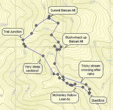
 (The image at the left is the vertical profile for the hike. The left section is the bushwhack ascent
while the right shows the descent down the main trail.)
(The image at the left is the vertical profile for the hike. The left section is the bushwhack ascent
while the right shows the descent down the main trail.)
![]()
![]() On Saturday, January 7th my wife and I accompanied a snowshoeing
group of about 15 people to the area of Frick Pond. The event was sponsored by Morgan Outdoors a shop
on the Main Street of Livingston Manor. The amount of snow in Livingston Manor barely
warranted the use of snowshoes but we went anyway. The conditions at Frick Pond were ideal. There
was a minimum of 8 inches of soft snow and, at times, over one foot. We waited for the rest of the group
at Frick Pond and then decided to part company. Most of the group decided to take the two mile,
flat route around the pond. My wife, another woman and myself decided to got to Hodge Pond. The trail
from Times Square to Hodge Pond is a significant climb especially on snowshoes. Most of the Big Rock
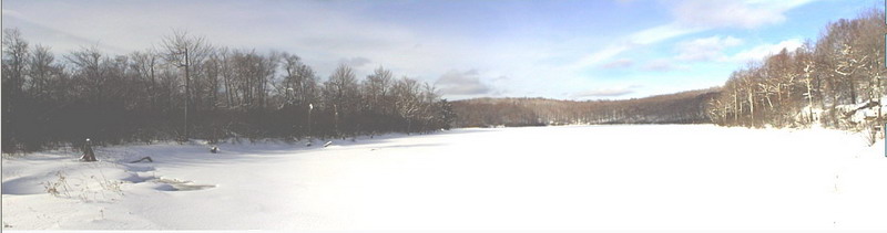
Trail had been packed my snowmobiles which made the going easier. The panorama above is the result
of combining four successive shot from Hodge Pond. On the way back we took the Flynn Trail which, after
climbing from Hodge Pond is relatively flat and the downhill. The downhill part of Flynn Trail made
the trip back seem short and easy despite the fact that there was no broken trail and at least a foot
of snow! We met several other people either skiing or snowshoeing.
On Saturday, January 7th my wife and I accompanied a snowshoeing
group of about 15 people to the area of Frick Pond. The event was sponsored by Morgan Outdoors a shop
on the Main Street of Livingston Manor. The amount of snow in Livingston Manor barely
warranted the use of snowshoes but we went anyway. The conditions at Frick Pond were ideal. There
was a minimum of 8 inches of soft snow and, at times, over one foot. We waited for the rest of the group
at Frick Pond and then decided to part company. Most of the group decided to take the two mile,
flat route around the pond. My wife, another woman and myself decided to got to Hodge Pond. The trail
from Times Square to Hodge Pond is a significant climb especially on snowshoes. Most of the Big Rock
Trail had been packed my snowmobiles which made the going easier. The panorama above is the result
of combining four successive shot from Hodge Pond. On the way back we took the Flynn Trail which, after
climbing from Hodge Pond is relatively flat and the downhill. The downhill part of Flynn Trail made
the trip back seem short and easy despite the fact that there was no broken trail and at least a foot
of snow! We met several other people either skiing or snowshoeing.
![]() On Wednesday, December 28th my wife and I wanted to
try out the snowshoes we got for Christmas. We headed off to Frick Pond even though there wasn't much
hope of finding snow. In the parking lot we decided we would try the snowshoes anyway. We started
out on the Quick Lake trail and turned right at Frick Pond on the Logger's Loop. There was enough
snow to make the snow shoeing worthwhile although we could have hiked without them. In several
areas we had to go off trail to avoid parts of the trail without snow or with too many rocks. We
went straight through Times Square and continued on the Logger's Loop until Iron Wheel Junction.
Here we turned left on the Quick Lake trail back to Frick Pond and then to the parking area. We
spent two hours covering a little under 4 miles and it was well worth the time and effort.
On Wednesday, December 28th my wife and I wanted to
try out the snowshoes we got for Christmas. We headed off to Frick Pond even though there wasn't much
hope of finding snow. In the parking lot we decided we would try the snowshoes anyway. We started
out on the Quick Lake trail and turned right at Frick Pond on the Logger's Loop. There was enough
snow to make the snow shoeing worthwhile although we could have hiked without them. In several
areas we had to go off trail to avoid parts of the trail without snow or with too many rocks. We
went straight through Times Square and continued on the Logger's Loop until Iron Wheel Junction.
Here we turned left on the Quick Lake trail back to Frick Pond and then to the parking area. We
spent two hours covering a little under 4 miles and it was well worth the time and effort.
![]() On Tuesday, December 27th Karl and I wanted to hike one of
the winter 35s so we headed to Panther Mountain. The snow had been decidedly reduced in volume by
some rain and warm weather. Because of the lack of snow, the plentiful rocks on this trail and
several rock scrambles on the trail we decided not to wear snowshoes. Several other cars were
in the parking area as we headed off to Giant Ledge. Panther Mountain looked dark and like it might
be snowing up there as we left the parking lot. The decision not to use snowshoes seemed like
a good one as there wasn't much snow on the way to Giant Ledge. Of the first three people we met
returning from Panther, two wore snowshoes and one did not. We stopped to talk to one person
who acknowledged that the snowshoes weren't really necessary but had not caused him any problems.
Descending into the col between Giant Ledge and Panther Mountain the weather change. The wind picked
up and we encountered deeper snow that had drifted in several areas. Some of the ascents on Panther
were VERY icy and made wearing crampons sound like a good idea. The snow on top of Panther wasn't
very deep. From the summit the only view was of clouds and mist. The trees at the top were
covered in frozen snow making then look all the more beautiful. The trip back wasn't very
difficult. From the Ledges back the weather was sunny again until we got back to the car.
On Tuesday, December 27th Karl and I wanted to hike one of
the winter 35s so we headed to Panther Mountain. The snow had been decidedly reduced in volume by
some rain and warm weather. Because of the lack of snow, the plentiful rocks on this trail and
several rock scrambles on the trail we decided not to wear snowshoes. Several other cars were
in the parking area as we headed off to Giant Ledge. Panther Mountain looked dark and like it might
be snowing up there as we left the parking lot. The decision not to use snowshoes seemed like
a good one as there wasn't much snow on the way to Giant Ledge. Of the first three people we met
returning from Panther, two wore snowshoes and one did not. We stopped to talk to one person
who acknowledged that the snowshoes weren't really necessary but had not caused him any problems.
Descending into the col between Giant Ledge and Panther Mountain the weather change. The wind picked
up and we encountered deeper snow that had drifted in several areas. Some of the ascents on Panther
were VERY icy and made wearing crampons sound like a good idea. The snow on top of Panther wasn't
very deep. From the summit the only view was of clouds and mist. The trees at the top were
covered in frozen snow making then look all the more beautiful. The trip back wasn't very
difficult. From the Ledges back the weather was sunny again until we got back to the car.