
What You Missed
Summer 2011
Summer 2011
![]()
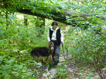
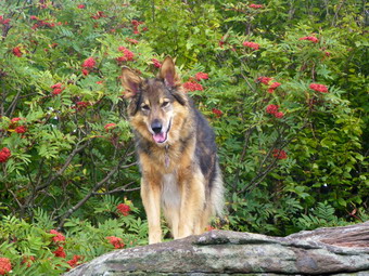
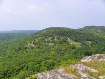
![]() On Monday, September 19th I decided to hike from Route 206 to Berry Brook Road over the Campbell Mountain, Pelnor Hollow and Mary Smith Trails. These are all part of the Finger Lakes Trail system and I had just bought the maps for the entire trail. Cindy and I have hike from Route 206 in the opposite direction many times but I had hiked over Brock Mountain only once. I decided that the it was most appropriate to hike through as I wanted to do the entire route and the return trip would add nothing to the experience. In addition, I calculated the one way distance to be about 6 miles and I did not have the time for a 12 mile hike! We drove both cars up Berry Brook Road from Roscoe. Along the way the condition of the road reminded USA of the destruction from the recent flooding. A town of Rockland DPW crew was working to repair one culvert and the road around it. The rest of the road surface had potholes where there was pavement and reverted to gravel in many places. We parked one car where the Mary Smith Trail crosses and then drove out the other end of Berry Brook Road to Route 30. The drive along the Pepacton Reservoir to Route 206 seemed to be both shorter and have better road then the drive up Berry Brook Road! We parked at the pulloff on Route 206 where the Campbell Mountain Trail crosses and crossed the road to begin our hike by 10:00 AM. The trail is a wide woods road at the beginning at stays this way for most of its length. We immediately began an ascent through hardwood forest that seemed exceptionally green. The trail was wet in places but these spots were easily avoided and this was the case for most of the hike. What also became evident as we hiked was that someone had recently been through to clean up the trail. All but the largest blowdowns were cut with a chainsaw and all the prickers and nettles were cut back a good distance. Hiking this trail can be a real pain but the work of the trail maintainers made it a real pleasure! For the first .5 miles the trail gains 450 feet with a few short but steep climbs. After that, the trail goes through the first of several switchbacks to give hikers a rest before gaining another 230 feet over the next .4 miles.
On Monday, September 19th I decided to hike from Route 206 to Berry Brook Road over the Campbell Mountain, Pelnor Hollow and Mary Smith Trails. These are all part of the Finger Lakes Trail system and I had just bought the maps for the entire trail. Cindy and I have hike from Route 206 in the opposite direction many times but I had hiked over Brock Mountain only once. I decided that the it was most appropriate to hike through as I wanted to do the entire route and the return trip would add nothing to the experience. In addition, I calculated the one way distance to be about 6 miles and I did not have the time for a 12 mile hike! We drove both cars up Berry Brook Road from Roscoe. Along the way the condition of the road reminded USA of the destruction from the recent flooding. A town of Rockland DPW crew was working to repair one culvert and the road around it. The rest of the road surface had potholes where there was pavement and reverted to gravel in many places. We parked one car where the Mary Smith Trail crosses and then drove out the other end of Berry Brook Road to Route 30. The drive along the Pepacton Reservoir to Route 206 seemed to be both shorter and have better road then the drive up Berry Brook Road! We parked at the pulloff on Route 206 where the Campbell Mountain Trail crosses and crossed the road to begin our hike by 10:00 AM. The trail is a wide woods road at the beginning at stays this way for most of its length. We immediately began an ascent through hardwood forest that seemed exceptionally green. The trail was wet in places but these spots were easily avoided and this was the case for most of the hike. What also became evident as we hiked was that someone had recently been through to clean up the trail. All but the largest blowdowns were cut with a chainsaw and all the prickers and nettles were cut back a good distance. Hiking this trail can be a real pain but the work of the trail maintainers made it a real pleasure! For the first .5 miles the trail gains 450 feet with a few short but steep climbs. After that, the trail goes through the first of several switchbacks to give hikers a rest before gaining another 230 feet over the next .4 miles.
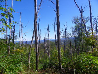
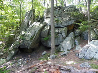
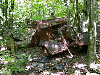 At about 1 mile we reached the false summit of Brock Mountain which, on many maps and GPS units, is marked as Brock Mountain. I began to notice piles of rock that did not look natural and I knew there was a quarry in this area. I walked up one pile of rock and began to look around. Nothing looked too extraordinary at first but my persistence paid off! Soon I saw a large and deep pit and was able to walk down into it. After taking a few pictures, I came up out of the pit and worked my way back to the trail. There were several other smaller but still impressive pits along the way. Back on the trail it was time to tackle the rest of the ascent up the "real" Brock Mountain. After a slight descent from the false summit the trail ascends about 300 feet to the top of Brock Mountain at about 1.9 miles into the hike. We arrived at just after 11:00 AM and I knew I had to watch the time to get to XC practice without being late. The trail does not actually pass over the highest point on the mountain where there is purported to be a USGS benchmark but we did top out at about 2440 feet. I did not worry about this as we descended the other side of Brock Mountain. As we started down what turned out to be a steep descent, there was an area where many of the trees were dead. I assumed this was from a forest fire. This did allow for some interesting views of the valley with another ridge beyond. After that, we continued the hike over the well-maintained but poorly marked trail. I guess whoever was doing the cleaning and clearing had not been given trail markers as they were very few and far between!
 At about 2.4 miles the trail headed north and then southeast after a short distance. This prominent switchback is not shown on the NYNJTC maps and was a little confusing. We had to be careful to keep watching for blazes since they are few and far between in places and there area lot of old roads and snowmobile trails. At 3 miles the trail turns almost 90 degrees to the right and heads northeast. Shortly, at 3.3 miles, we again turned 9 degrees1 to the right and headed southeast. In both cases there were snowmobile trails or woods roads in the area of the turns. There are really no views along the way but the woods are pretty. In some places there are stone walls and the hint of a foundation. At 3.85 we made another 90 degree turn onto an old road which was eroded but very recognizable with stone walls on both sides. The was a slight uphill but the trail was mostly level for the next .3 miles. At this point the Campbell Mountain Trail ends. To the right is the Little Spring Brook Trail that leads out to Route 206. We turned right onto the Pelnor Hollow Trail.
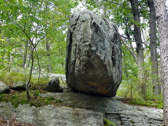
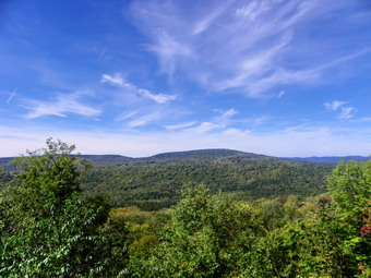 In the next 1 mile the trail climbs over 400 feet through mixed hardwood and evergreen forest. There was some running water at the beginning but after that the trail dried out. There was a lot of blowdown in places but all had been cleared. There were some steeper places and by new our legs were tired. Near the top of this climb the trail levels and our reward was the Split Rock Lookout. At the lookout there is a large boulder and an area where the part of the bedrock has separated. The light was a little bright but the views to the west were good. There isn't much to see other than trees and mountains except for one house on the far ridge. They must have a great view and an interesting drive in the winter! The lookout was 5.2 miles into the hike and we arrived at about 12L40 PM. From the lookout the trail ascends for about .1 miles at a 26% grade. This isn't very far but it looks like a WALL from the bottom. At 5.3 miles, we turned left on the Mary Smith Trail as the Pelnor Hollow Trail continues straight ahead. The Mary Smith Trail is an almost continuous downhill to Berry Brook Road. There were some spots where a lot of brush and blowdowns had been cleared. There were also a few tricky descent through rocks and around trees. On the way down we met a couple coming up from the parking area. They were hiking through on the Pelnor Hollow Trail and were the only people we saw on the hike. After 1.1 miles and a drop of over 500 feet we ere back at the car. We had hiked 6.4 miles in 3.5 hours. All that was left was to drive back out to Route 206 to pick up the other car.
![]()
![]() On Saturday, September 17th I wanted to do a hike in the Harriman/Bear Mountain area. I knew I didn't want to pay the parking fee at Bear Mountain and I knew there was a cross country meet in the morning. I thought I might park at the lot off Perkins Drive and do the West Mountain and Torne loop from there. As I exited the Quickway and got on Route 6 I decided to change plans and park at the lot where the Long Path crosses Route 6. I had parked here before and hiked to the Torrey Memorial but this time I was going to hike the other way and make a loop of some kind. Sheba and I arrived at 10:15 AM and started hiking immediately. We walked out to Route 6 and crossed being careful of the cars that were NOT paying any attention to the HIKERS signs! The Long Path crosses almost directly across from the exit to the parking area. The trail follows wide woods roads in many places and I had to be careful since there are many fire roads and other paths that crisscross the trails and it is easy to get lost even with a map. The Long path heads almost directly southwest and climbs around 400 feet in the first 1.8 miles. Just before another climb we stopped at a series of rock overhangs which are labeled "cave shelter" on the NYNJTC maps. After taking a few picture, we climbed to the top of the rise and walked along a flat part of the trail to a rock shelter at 2.0 miles. The shelter faces west and the map marks it as a viewpoint. Like so many of the places that were once viewpoints the trees have grown to block most of the view. I took a few pictures before a quick little descent to the junction with the yellow Menomine Trail. At the trail junction we went straight ahead looking for Hippo Rock.
On Saturday, September 17th I wanted to do a hike in the Harriman/Bear Mountain area. I knew I didn't want to pay the parking fee at Bear Mountain and I knew there was a cross country meet in the morning. I thought I might park at the lot off Perkins Drive and do the West Mountain and Torne loop from there. As I exited the Quickway and got on Route 6 I decided to change plans and park at the lot where the Long Path crosses Route 6. I had parked here before and hiked to the Torrey Memorial but this time I was going to hike the other way and make a loop of some kind. Sheba and I arrived at 10:15 AM and started hiking immediately. We walked out to Route 6 and crossed being careful of the cars that were NOT paying any attention to the HIKERS signs! The Long Path crosses almost directly across from the exit to the parking area. The trail follows wide woods roads in many places and I had to be careful since there are many fire roads and other paths that crisscross the trails and it is easy to get lost even with a map. The Long path heads almost directly southwest and climbs around 400 feet in the first 1.8 miles. Just before another climb we stopped at a series of rock overhangs which are labeled "cave shelter" on the NYNJTC maps. After taking a few picture, we climbed to the top of the rise and walked along a flat part of the trail to a rock shelter at 2.0 miles. The shelter faces west and the map marks it as a viewpoint. Like so many of the places that were once viewpoints the trees have grown to block most of the view. I took a few pictures before a quick little descent to the junction with the yellow Menomine Trail. At the trail junction we went straight ahead looking for Hippo Rock.
 We found Hippo Rock at 2.3 miles into the hike and it really DID look like a hippo from the front. I took some pictures before heading back to the trail junction and turning right on the yellow Menomine Trail heading generally southeast. The trail is a long descent along a woods road and soon we were passing by Lake nays. At 3.6 miles we crossed Seven Lakes Drive and headed toward Silvermine Lake at about noon. Several groups were picnicking in the picnic area as we walked by. We headed toward Silvermine Lake and walked the trail along the west shore of the lake. Several groups of scouts passed us on our way along the lake. I stopped to take a few pictures and then continued on the trail heading for the Brien Memorial Shelter. Over the next .6 miles the trail gains 320 feet to the site of the shelter. On the way we passed a couple hiking up the trail and I talked to them about the mines on Black Mountain. As Sheba and I continued up the trail we met yet another group of scouts heading down passed us. We arrived at the shelter and trail junction at 12:45 PM at about 5.3 miles into the hike. I took some pictures and we took time for lunch and a drink before turning left onto the Appalachian Trail and starting up a short, steep rock climb. This trail is marked in white for the AT but also has red blazes as it is part of the Ramapo Dunderberg Trail. After reaching the top of the rock scramble, the trail flattens some with a few ups and downs. The skies were cloudy but the temperatures were still warm enough. We had hiked about .5 miles from the shelter when I decided to consult the map again. I reached into my pocket and...NO MAP! I checked my other pocket and still couldn't find it. I decided to go back and look for it despite the fact that I knew where I was going. The map and I had been together for some time. I started at an accelerated pace back toward the shelter. On the way back I met the couple I had first encountered on the way up to the shelter. They had not seen the map so Sheba and I continued back to the shelter. I scoured the ground carefully all the way back to the shelter but did not find the map until...I checked my pack! I was happy to have the map and really didn't mind the added distance. So now we turned around and headed toward Black Mountain at an even faster pace!
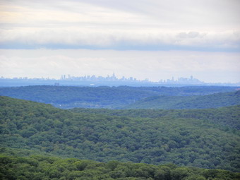 For about .9 miles from the shelter the trail rolls up and down slightly until at 7.2 miles it turns to the right. Now we were hiking southeast rather than northeast. At this turn we met the couple again. They were trying to decide whether to turn left to go back to the car or right to at least get to the lookout above. I talked to them briefly and then Sheba and I started up Black Mountain. After a short but steep climb we were at the viewpoint over Silvermine Lake. This lookout is really worth the climb and we stopped to take some pictures before heading for the summit. We were on the summit just before 2:00 PM at 7.7 miles into the hike. The views were very hazy and the skies were still overcast. Deposits the conditions the New York City skyline was easy to spot. From the summit we started down a very steep descent of almost 400 feet in .35 miles. A little further on we turned left and headed almost due north on the blue 1779 Trail. The trail parallels the Palisades Parkway which is just over a ridge to the right. There were no views and the trail was a little wet in places. still, the 1.6 miles to Seven Lakes drive near the Long Mountain traffic circle were pleasant enough. We crossed the road and walked to the traffic circle. We walked up Route 6 a little before crossing to the other side where we would pick up the 1179 Trail again...if I could only find it. There were no markers where we crossed and after a diversion to the west we headed back east to the area just north of the traffic circle. There was one blaze on a tree and then nothing. After an uninteresting walk up a path, I looked from the tree with the blaze across a gravel storage area and found another blaze on a pole and a little farther on another on a tree. We entered the woods to continue the hike.
 The trail headed north toward the Popolopen Gorge Trail and Turkey Hill Lake just skirting a climb up Summer Hill. After about .6 miles, I decided to walk straight ahead on Summer Hill road rather than take the circuitous route on the trail. When I crossed a small stream, I knew something was wrong but I continued to head north and east. I turned around and walked back over the stream to see the turn toward Turkey Hill Lake that would have been obvious if I had stayed on the trail! Soon we were at the dam for the lake and I took a few pictures. We continued around the west shore of the lake which had several groups of people at various spots on the shore. After a few more stops for pictures, I decided it was time to get back to the car. From the dam it was all uphill for the next .9 miles until we hit the Long Path again at 12.2 miles. We turned left on the Long Path and hiked the .3 miles back to the car. It was 4:15 PM and we had covered 12.5 miles in 6 hours.
![]() On Wednesday, September 14th I decided to try another hike in Delaware County this time staying as "local" as could. I decided to park on Mary Smith Hill Road at the trail head and hike to Cabot Mountain and back. This would require hiking over Middle Mountain and Beech Hill twice! I had a limited amount of time so, of course, I got a late start arriving at the trail head and starting the hike at around 9:30 AM. The road was in good shape even when it turned to dirt part way up. When you drive to the trail head, don't give up and think you are in the wrong place or you have missed the parking area. The lot is well-marked on the right side of the road. The road beyond this point looked so good I thought I might drive out to Beech Hill Road and take that route home. There was another car parked in the lot which is unusual but they had not signed into the register and there are two ways to hike from this trail head. Sheba and I got on the trail right away and started hiking east toward Middle Mountain. The trail was damp even wet and muddy in pleas which was not surprising as we have had a lot of rain. Someone had been through to knock down many of the prickers, nettles and other brush. This entire trail turned out to be a true Catskills trail with rocks, roots, prickers, nettles, damp places, wet spots and blowdown! The skies were very overcast and it looked like it might rain several times. The temperatures were in the 60's and warmer to the high 70's during the day. The hike was longer and harder than I expected. I decided to take pictures on the way back and get to my destination first. As it turned out, there were no clear viewpoints along the way and even the Middle Mountain Vista had grown in with brush and trees. Even if there had been viewpoints, they would have been obscured by the haze.
On Wednesday, September 14th I decided to try another hike in Delaware County this time staying as "local" as could. I decided to park on Mary Smith Hill Road at the trail head and hike to Cabot Mountain and back. This would require hiking over Middle Mountain and Beech Hill twice! I had a limited amount of time so, of course, I got a late start arriving at the trail head and starting the hike at around 9:30 AM. The road was in good shape even when it turned to dirt part way up. When you drive to the trail head, don't give up and think you are in the wrong place or you have missed the parking area. The lot is well-marked on the right side of the road. The road beyond this point looked so good I thought I might drive out to Beech Hill Road and take that route home. There was another car parked in the lot which is unusual but they had not signed into the register and there are two ways to hike from this trail head. Sheba and I got on the trail right away and started hiking east toward Middle Mountain. The trail was damp even wet and muddy in pleas which was not surprising as we have had a lot of rain. Someone had been through to knock down many of the prickers, nettles and other brush. This entire trail turned out to be a true Catskills trail with rocks, roots, prickers, nettles, damp places, wet spots and blowdown! The skies were very overcast and it looked like it might rain several times. The temperatures were in the 60's and warmer to the high 70's during the day. The hike was longer and harder than I expected. I decided to take pictures on the way back and get to my destination first. As it turned out, there were no clear viewpoints along the way and even the Middle Mountain Vista had grown in with brush and trees. Even if there had been viewpoints, they would have been obscured by the haze.
The climb up Middle Mountain got steep in a few places and there were several large trees across the trail and many smaller branches. Between .5 miles and .6 miles the trail winds its way up over a rocky patch. At the top of the climb the trail levels and makes a big switchback before heading back toward the summit which we reached at about 1 mile and just before 10:00 AM. From the summit of Middle Mountain the trail loses almost 300 feet to the Col with Beech Hill. The climb to Beech Hill wasn't long but I was a little tired at this point. From the top of Beech Hill the trail was not cleared as well and there was some blowdown that forced us off trail and into the nettles and prickers. This descent was also VERY wet and muddy in places. As I was coming down I remembers that we had one more hill to climb before coming back to climb back up this mess. In .6 miles we had dropped over 500 feet and were on a small private road. We turned right and walked out to Beech Hill Road where we turned right and Walk to the trail head for the Touch Me Not Trail to Cabot Mountain. We had walked 2.5 miles over hilly, rough trails and it was 10:45 AM. The hike up Cabot started along a very wet woods road. The land was posted on both sides as we started to climb. The first .25 miles weren't bad but then the trail got serious. There were several blowdowns on parts of the trail where it was hard to get around them. The trail got steep in spots. I had wanted to get to the Beaverkill Vista but that was another .4 miles beyond the summit and I was already feeling the pressure of getting back in time for practice. In .5 miles the trail ascended about 600 feet and then leveled off for a pleasant walk of .35 miles to the last climb. We ascended another 125 feet over the next .3 miles and walked a little passed the summit before turning around to walk back. The hike back worried me as I was already tired. I knew the hike down would not be as hard as the hike up but these trails are still tricky and it is hard to get up any momentum. Also, after hiking down Cabot we would have to hike back over Beech Hill and Middle Mountain. We turned around at 11:40 AM and were at the foot of Beech Mountain by 12:30 PM having covered 6.6 miles. Although the climb up Beech Mountain is steep it didn't seem that hard and by 1:00 PM we were headed down Beech Hill to the col with Middle Mountain. This part seemed to go quickly also and soon we were going down Middle Mountain, through the switchback, over the rocks and toward the parking area. We arrived at 2:00 PM covering the 7.8 mile hike in just over 4.5 hours.
![]()
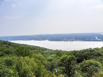
![]() On Monday, September 12th I decided to again respect the ban on hiking in Greene and Ulster counties so I headed to Dry Brook Ridge near Margaretville in Delaware County. As I drove up Route 206 toward Downsville, there was no evidence of flooding from the excessive rain. Although the Pepacton Reservoir looked very muddy, Route 30 around the reservoir showed no damage. From the bridge the New York City roads were good until just before the junction with Route 30. There was debris along the road and several; cones marked places where the road had been undermined. I turned right onto Huckleberry Road and then left onto Hill Road. I parked the car at the small parking area and we crossed the road to get on the red Huckleberry Loop Trail by 9:30 AM. I decided that this was a day to hike as fast as we could to the lookouts and back without stopping for pictures except at the viewpoints. The temperature was in the high 60's when we started but it did seem warm. The very first part of the trail was wet but was drier the further we climbed. This route passes through a red pine plantation planted by the CCC and the tall straight tees are very interesting. The path is covered by pine needles and is almost an ideal surface for hiking. As we hiked up the trail, the trees changed from the pines to hardwoods. In several places around 1 mile, there was some large blowdown that had already been cleared using chainsaws. I hadn't hiked from this direction since early last winter and it was hard for me to tell when the work had been done. Someone had cut back most of the brush and prickers and we made good time up to the ridge at 1.85 miles. The elevation gain over this distance is a respectable 1150 feet. We had been hiking generally northeast and now the trail turned almost 90 degrees to head southeast. The trail continued another .4 miles to the junction with the blue Dry Brook Ridge Trail.
On Monday, September 12th I decided to again respect the ban on hiking in Greene and Ulster counties so I headed to Dry Brook Ridge near Margaretville in Delaware County. As I drove up Route 206 toward Downsville, there was no evidence of flooding from the excessive rain. Although the Pepacton Reservoir looked very muddy, Route 30 around the reservoir showed no damage. From the bridge the New York City roads were good until just before the junction with Route 30. There was debris along the road and several; cones marked places where the road had been undermined. I turned right onto Huckleberry Road and then left onto Hill Road. I parked the car at the small parking area and we crossed the road to get on the red Huckleberry Loop Trail by 9:30 AM. I decided that this was a day to hike as fast as we could to the lookouts and back without stopping for pictures except at the viewpoints. The temperature was in the high 60's when we started but it did seem warm. The very first part of the trail was wet but was drier the further we climbed. This route passes through a red pine plantation planted by the CCC and the tall straight tees are very interesting. The path is covered by pine needles and is almost an ideal surface for hiking. As we hiked up the trail, the trees changed from the pines to hardwoods. In several places around 1 mile, there was some large blowdown that had already been cleared using chainsaws. I hadn't hiked from this direction since early last winter and it was hard for me to tell when the work had been done. Someone had cut back most of the brush and prickers and we made good time up to the ridge at 1.85 miles. The elevation gain over this distance is a respectable 1150 feet. We had been hiking generally northeast and now the trail turned almost 90 degrees to head southeast. The trail continued another .4 miles to the junction with the blue Dry Brook Ridge Trail.
 The Dry Brook Ridge trail was wet and muddy in several places over the next .7 miles since it is almost flat. The forest was very green and there was only one or two areas of blowdown in the path and these were easily negotiated. In one of the muddy areas I saw a very LARGE bear paw print. At 2.95 miles we hit a little ascent for .3 miles that led to the lookouts west and south. It was 10:50 AM which meant we had hit the lookouts in 1 hour and 20 minutes! This was the first time we stopped and I took off my pack to get out the camera. We both had a drink and I gave Sheba a snack before I walked out onto the rocks to take some pictures. A heavy haze hung over everything but the sun was starting to break through.I took a number of pictures and discarded many of them but the ones that remained were interesting. I gathered my equipment and we headed back the way we had come. The return route is mostly flat and down with two of there short ascents. After the turn down off the ridge, we met the only other person we would see on the hike. We exchanged greetings and continued in opposite directions. As we passed through the pines again, I just had to stop and take a few shots of these majestic trees. We were back at the car by 12:10 PM having covered the 6.5 mile hike in 2 hours and 45 minutes.
![]()
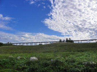
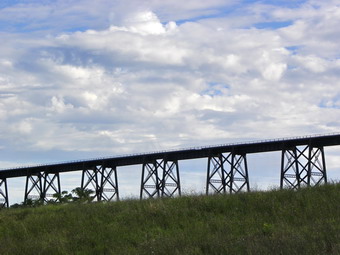
![]() On Saturday, September 10th I decided to get back into the woods after a week of rain and commitments had interfered with my hiking.I wanted to respect closing by the DEC of the Catskill trails in Ulster and Greene counties so I chose to try attempt to hike at Schunemunk Mountain in Orange County. I knew that this area had been hit by flooding and was fully prepared to implement a backup plan if this one did not work. I noticed from by trip reports that it had been over two years since I had been on this hike! I was glad that as I drove down the Quickway from Livingston Manor the skies began to clear. This hike has many nice viewpoints and I wanted to be able to take some pictures. The forecast was for partly sunny skies and that forecast looked to be accurate. As I drove through Washingtonville on Route 94, I noticed that every house had a pile of carpet, furniture and black garbage bags out front. Several lawns and low-lying areas were still flooded! I turned right on Orrs Mills Road just passed the sign that said Salisbury Mills. After that it was a right on Clove Road and then a left on Otterkill Road to the trailhead parking area. There was only one car parked as we pulled in just before 9:00 AM. The parking area has a clear view of the Moodna Viaduct which is used by Metro North to span the valley. It is the largest free-standing steel structure east of the Mississippi. To begin the hike we walked up the road toward the viaduct where the trail actually begins. We passed another hiker coming toward us. I thought he either got a very early start or did not hike a very long distance. We turned into the woods on the white Trestle Trail just before the viaduct and I let Sheba off her leash. I had intended to go up the Trestle Trail to the ridge and then hike out one ridge and back on the other. As we approached turn for the red Otterkill Trail I developed a new plan. I decided to hike all the way to the other end of the Otterkill Trail and then up the Dark Hollow Trail to the eastern ridge. After a visit to the Megaliths, I would have to decide whether I wanted to hike back on the eastern ridge or attempt to cross Barton Swamp to get to the western ridge. I knew that the amount of rain that had fallen over the week might make this route interesting.
On Saturday, September 10th I decided to get back into the woods after a week of rain and commitments had interfered with my hiking.I wanted to respect closing by the DEC of the Catskill trails in Ulster and Greene counties so I chose to try attempt to hike at Schunemunk Mountain in Orange County. I knew that this area had been hit by flooding and was fully prepared to implement a backup plan if this one did not work. I noticed from by trip reports that it had been over two years since I had been on this hike! I was glad that as I drove down the Quickway from Livingston Manor the skies began to clear. This hike has many nice viewpoints and I wanted to be able to take some pictures. The forecast was for partly sunny skies and that forecast looked to be accurate. As I drove through Washingtonville on Route 94, I noticed that every house had a pile of carpet, furniture and black garbage bags out front. Several lawns and low-lying areas were still flooded! I turned right on Orrs Mills Road just passed the sign that said Salisbury Mills. After that it was a right on Clove Road and then a left on Otterkill Road to the trailhead parking area. There was only one car parked as we pulled in just before 9:00 AM. The parking area has a clear view of the Moodna Viaduct which is used by Metro North to span the valley. It is the largest free-standing steel structure east of the Mississippi. To begin the hike we walked up the road toward the viaduct where the trail actually begins. We passed another hiker coming toward us. I thought he either got a very early start or did not hike a very long distance. We turned into the woods on the white Trestle Trail just before the viaduct and I let Sheba off her leash. I had intended to go up the Trestle Trail to the ridge and then hike out one ridge and back on the other. As we approached turn for the red Otterkill Trail I developed a new plan. I decided to hike all the way to the other end of the Otterkill Trail and then up the Dark Hollow Trail to the eastern ridge. After a visit to the Megaliths, I would have to decide whether I wanted to hike back on the eastern ridge or attempt to cross Barton Swamp to get to the western ridge. I knew that the amount of rain that had fallen over the week might make this route interesting.
 The Otterkill Trail parallels the railroad tracks for 2.1 miles. Although the total ascent amounts to 300 feet the change in elevation from one end to the other is 10 feet! It is flat but rolls a little. This does not mean that it is boring. As we got on the trail and went up a little rise there was a lookout to the east. This viewpoint was not very high but offered a nice view of the hills which were still covered in haze with a few low-hanging clouds. As we continued to walk, I looked at to see Sheba standing with six feet of a pair of deer. They looked at each other and then the deer walked away. The trail was wet for almost the entire length and the parts that were not wet showed that there had recently been water running across the trail. Along the trail I began to notice and extensive network of stone walls. Some of these wall were low but many were built up. These remnants of a past way of life always interest me. The solid construction of these walls made them permanent and a real indication that someone worked hard and sweated hard to farm the land. At 1.2 miles the trail turns sharply to the left on one of the many woods roads in the park. We walked straight ahead down to Baby Brook so that I could check out the water volume. From the sound the brook was running high and I was not disappointed. The problem was getting a clear shot of the small cascades was not easy! I decided to abandon the effort and we walked up to the main trail and to the bridge over Baby Brook. The bridge showed no damaged and we walked downstream a bit. There is a tunnel here to carry the railroad over the brook. There was also a small falls below the bridge and I was able to get some pictures this time. We continued along the trail until at 2.4 miles there was another nice falls and a crossing of Dark Hollow Brook that had no bridge. This crossing is probably easy in most cases but after a we of storms the water was high and rushing fast. I might have jumped but the landing on the other side was small and consisted of slippery rocks. I was going to check out the railroad bridge but found a spot downstream to cross. Almost immediately after the crossing the Otterkill Trail ended and the dark Hollow Trail started up the mountain to the right.
 The Dark Hollow Trail followed an old woods road generally southeast and up the ridge. The road was eroded and very rocky in places with a few stream running down the trail in spots. The road makes several switchbacks in places as the grade would have been too steep for horse drawn wagons otherwise. I did begin to wonder why there was a road to the top of the ridge! At about 2.9 miles there was a nice lookout after a short climb. The views to the east and north were very nice with some haze still hanging around. We continue to hike after I took some pictures. In some spots the trail leaves the road and makes a short climb up to the next level to rejoin the same road. This cuts a little distance and avoids the long switchbacks. These "shortcuts" also make the hike more interesting. As the trail climbed two things happened. First, there were at least four places where I thought we were on the top of the ridge. Second, the map showed two crossings of Dark Hollow Brook and we made at least four. Neither of these proved an impediment to the trip. At 3.6 miles there was another viewpoint on top of a massive rock outcrop. This one had less spectacular views. We climbed again and the trail flattened at about 3.8 miles in an open area with incredible views in all directions except to the west. This might be the best viewpoint in the whole park. It was especially nice since I had never been there before! I took a lot of pictures before we headed on up the trail. I was SURE we were at the top of the ridge but I was fooled again. At about 4 miles we were at the end of The Dark Hollow Trail at Dark Hollow Junction. It was 11:15 AM when we turned left onto Jessup Trail which is also the Highlands trail. We were headed toward the Megaliths.
 The Jessup Trail winds its way along the western ridge over many open rock faces with scrub pines. This is an entirely different ecology than at the lower elevations. At times the trail climbs over rock outcrops and at others dives into the pines. At 4.3 miles we were at the spur trail to the Megaliths and we turned right and walked the short distance. I approached quietly since the local vultures often hang out on the rocks surveying the countryside below. This time we had the rocks to ourselves and I took pictures of the scenery in the distance and some of the rocks themselves. We had a drink and a snack. Now it was time to decide on the route for the next part of the hike. I decided to try crossing Barton Swamp since it was such a short distance that turning back would be no longer than getting across. At 4.6 miles we turned right onto the blue Western Ridge Trail and started down to the swamp. The trail is routed over some open rocks faces before it start to descends the ridge. Just at the point it starts the descent is another nice viewpoint. On the descent the trail becomes very narrow and all the rocks were damp from runoff! I made sure I used my poles or hung onto some brush on this traverse. As we hiked Sheba and I could here some voices below. From the comments they were headed our way and they were having trouble crossing the swamp. I decided not to turn back and continued down to Se for myself. Just before the swamp crossing I met the group looking none the worse for their hike. The leader of the group was the first hiker I had met that day back by the viaduct! We talked for a short time and then went in opposite directions. Crossing the swamp was challenging as there was a lot of water and some of the corduroy was floating.
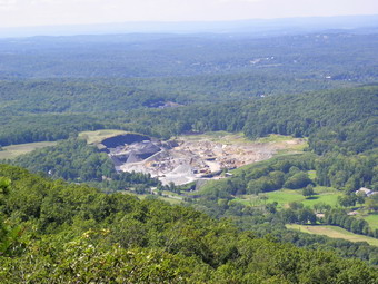 Once on the other side we of the swamp we turned right on the red Barton Swamp Trail and then turned left almost immediately to head up to the western ridge. We hit the Long Path around 12:10 PM at about 5 miles. The trail here runs right along an open rock face pitched at about 40 degrees. It soon turns up to the safety of the ridge but that first part is interesting. Once on the ridge we picked up our pace even though there are places where the trail is sited directly on top of a knife edge of rock. There are a few ups and down to keep things interesting. There are also several informal paths which can mislead hikers who do not pay attention. The further we walked along the ridge the better the views became. There was a nice lookout at 5.6 miles and then the Sweet Clover`Trail came over from the Eastern Ridge at 6 miles. Just passed this junction another lookout gives a nice view of the valley. Prominent in the view are a sand and gravel pit to the southwest and a lake with homes to the north. Along the way we met three hikers who asked about the route we had taken and the swamp crossing. I gave them information and we were on our way. Just before the next junction with the Jessup Trail at 6.6 miles we met a solo hiker with a hand drawn map. I supplied here with some information and ten Sheba and I head to the trail junction where we turned to the right to follow the Jessup Trail briefly. When the Jessup Trail met the Trestle Trail we continued straight ahead on the Trestle Trail. This trail is always rocky with small pebbles which like to roll making the footing tricky. At 7.45 miles we walked out to a memorial bench which has a great view. After I took some pictures, we headed back down the trail to the road and our car. By the time we got to the parking area the lot was full with several cars parked on the road. We covered 8.2 miles in just under 5 hours with plenty of stops to take pictures.
![]()
![]() On Saturday, September 3rd I decided to go on another meetup group hike. This time it was from The Dunderberg Trail head on Route 202 to the Timp. Once at the Timp a decision would be made about the rest of the hike. A comment was made about going to West Mountain with its stone shelter. There was some confusion about the parking area where we would meet so I wanted to get there a little early. As I was driving over Long Mountain Parkway (Route 6), there was very little damage showing from Tropical Storm Irene. At the traffic circle, Seven Lakes Drive was close and there was some evidence of flooding. The drive through Bear Mountain Park was also uneventful with only a few areas that had some fallen trees. At the traffic circle I took the exit down to Route 202 and headed toward the Dunderberg parking area. There were a few cars parked at the Cornell Mine trail head. The directions said that the parking area was 4 miles from the Bear Mountain traffic circle but they did not say which traffic circle! After about 3.3 miles I arrived at the parking area that I have always used at the Timp-Torne trail head. The problem was that the parking for the 1777 trail that can also be used to get to the Timp is another .5 miles down the road putting it closer to the 4 mile distance. I pulled into the parking area to wait for others from the group. It was about 9:35 AM and we didn't have long to wait as others began to arrive. Through a series of cell phone calls everybody ended up where we were parked. There were also a number of people that were not with our group. This hike is a popular one and it may have been that people were trying to stay away from the Catskills after the storm. As we gathered it was clear that many of the people knew each other and had hiked together before. I introduced my self and Sheba. As is the custom with this group, several people were a little late but we pushed off at about 10:15 AM. I wasn't sure who was leading was or what the final hiking plan was. We walked south on Route 202 a bit to pick up the blue Timp-torne Trail. As we walked through the dense vines and brush that cover the trail near the beginning, I though that the people up front were setting a fast pace that was leaving a few of the hikers behind. I quickened my pace as we started up the steep and narrow path to the ridge. No one seemed interested in the stone tunnel on the left side of the path as we climbed. I though that perhaps everyone knew the history of the area. The tunnel is from the aborted Dunderberg Spiral Railway which is an interesting story. Many of the trails in this area were used by both the British and Americans during the Revolutionary War. Troops were marched back and forth in an effort to control several "choke points" on the Hudson River particularly the one near West Point.
On Saturday, September 3rd I decided to go on another meetup group hike. This time it was from The Dunderberg Trail head on Route 202 to the Timp. Once at the Timp a decision would be made about the rest of the hike. A comment was made about going to West Mountain with its stone shelter. There was some confusion about the parking area where we would meet so I wanted to get there a little early. As I was driving over Long Mountain Parkway (Route 6), there was very little damage showing from Tropical Storm Irene. At the traffic circle, Seven Lakes Drive was close and there was some evidence of flooding. The drive through Bear Mountain Park was also uneventful with only a few areas that had some fallen trees. At the traffic circle I took the exit down to Route 202 and headed toward the Dunderberg parking area. There were a few cars parked at the Cornell Mine trail head. The directions said that the parking area was 4 miles from the Bear Mountain traffic circle but they did not say which traffic circle! After about 3.3 miles I arrived at the parking area that I have always used at the Timp-Torne trail head. The problem was that the parking for the 1777 trail that can also be used to get to the Timp is another .5 miles down the road putting it closer to the 4 mile distance. I pulled into the parking area to wait for others from the group. It was about 9:35 AM and we didn't have long to wait as others began to arrive. Through a series of cell phone calls everybody ended up where we were parked. There were also a number of people that were not with our group. This hike is a popular one and it may have been that people were trying to stay away from the Catskills after the storm. As we gathered it was clear that many of the people knew each other and had hiked together before. I introduced my self and Sheba. As is the custom with this group, several people were a little late but we pushed off at about 10:15 AM. I wasn't sure who was leading was or what the final hiking plan was. We walked south on Route 202 a bit to pick up the blue Timp-torne Trail. As we walked through the dense vines and brush that cover the trail near the beginning, I though that the people up front were setting a fast pace that was leaving a few of the hikers behind. I quickened my pace as we started up the steep and narrow path to the ridge. No one seemed interested in the stone tunnel on the left side of the path as we climbed. I though that perhaps everyone knew the history of the area. The tunnel is from the aborted Dunderberg Spiral Railway which is an interesting story. Many of the trails in this area were used by both the British and Americans during the Revolutionary War. Troops were marched back and forth in an effort to control several "choke points" on the Hudson River particularly the one near West Point.
 The path had a few blowdowns to negotiate which made hiking the steep trail more difficult especially with a group. This trail is short but steep and has a lot of angular rocks under foot. Several hikers did not have poles and some were carrying water bottles in their hands. It was not surprising that these people were having a tough time with the climb. At the top of the first climb the trail does not level off but continues to climb toward the top of the ridge. The steepness is mitigated by numerous switchbacks many of which follow the graded bed of the railway. The trail begins by heading southwest but then goes through a switchback to the northwest before returning to its original direction. At just less than a mile there were several large trees across the trail and a few hikers from the group were waiting for those further behind. Sheba and I walked through to the next tunnel and stopped so that I could take pictures. This tunnel was blasted part of the way through the mountain when money ran out and the project was halted. The skies were brighter than I had expected since the forecast was for partly sunny. When I could get a glimpse through the trees down to the river there did appear to be a lot of haze especially in the distance. As I took pictures a group of hikers caught up and I explained the history of the railway which none of them knew. We walked on along an obvious railroad bed and then came to another climb at 1.45 miles that starts a switchback that heads northeast, gains elevation and then makes a 180 degree turn to head southwest. I stopped just before the turn with one of the women from the group and we took pictures of the Indian Point Nuclear Power Plant below. Others from the group caught up and I headed out at a faster pace in an effort to catch the leaders up front. Along the way the trail continues to climb and in one section passes over a long spine of rock with some interesting cairns. I took some pictures, the group caught up and I started in again.
 I had decided I would stay on the Timp-Torne Trail all the way to the Timp. One of the problems with hiking in Harriman is the number and variety of marked and unmarked trails.We passed through a little valley where the 1777 trail crosses and continued up the next hill toward our goal. Over the next .4 miles the trail follows roads and then veers off them and you have to be alert. It passes between and around some impressive rock formations before ascending what many maps show as the Timp.There is no view from this bump and the NYNJTC maps correctly identify the next bump as The Timp. To get there we walked down a short descent and across the red Ramapo Dunderberg Trail and then up to a nice viewpoint and up again to a better one. On the way up I met two young men who ha walked over from Bear Mountain and we spoke briefly. The view from The Timp is good but the haze made it less spectacular. The West Mountain Shelter was clearly visible. The Shelter does not look too far away but the descent and ascent is significant. In addition, once you arrive there you must turn around and retrace your path or be faced with a LONG loop especially since the trails in Doodletown were closed because of downed power lines! I had already decided to head over the Dunderberg Mountains on the Ramapo Dunderberg Trail since I wanted to pass over Bald Mountain and check out the Cornell Mine. This was a trip I had done several times and I knew about how long it would take. As I was getting ready to leave many of the other hikers arrived. O made a comment about the leaders not waiting for us. One of the members of the group told me that they we BEHIND us in the slower group and that I was the first to arrive. I found this hard to believe and was chagrined to know that I had pressed ahead to catch people who were not there! We came to the conclusion that I had passed them early on when they had pulled off the trail briefly. No one else wanted to head out with me so Sheba and I got going. As we refaced our path back to the Ramapo Dunderberg Trail, we met the rest of the group. I explained my plans and we wished each other a safe hike. Sheba and I hit the red trail and turned left toward Bald Mountain.
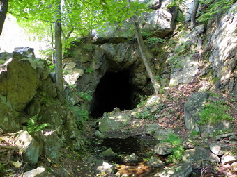
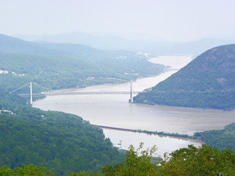 The trail descends some and then rolls across several hills on the way to the climb up Bald Mountain. On one short ascent I met a couple headed in the opposite direction. She was wearing bear bell and we spoke briefly discussing the hike and the bear situation in the park. We continue to walk and at one point I looked up to see a large back form round a corner. The black lab-shepherd mix didn't look much like a bear on the second glance but he did give me a start. The young couple that accompanied the dog and were very pleasant and knowledgeable about the trails and their history. We continued in our separate directions. After crossing a little stream and starting a climb, we met another solo hiker heading toward us. Later, just at the base of Bald Mountain, I began to hear classical music! A group of six hikers passed and the first had a "boom box" in his pack blaring out the music. For from being an annoyance it was novel and inspiring. As we climbed the mountain, a group of at least 20 younger hikers passed us going down. Everybody had to say "Hi" to Sheba. Soon we were near the top of Bald Mountain and then on the summit. We were 4.6 miles into the hike and it was 1:00 PM. The lookout has some nice views but the haze made the conditions less than ideal. There was a group of four hikers at the lookout and we said "Hello". I took pictures of the Bear Mountain Bridge, the Perkins Tower and Iona Island. When we were ready to leave, we simply walk off the north face of the mountain leaving the other hikers with surprised looks. I was a little pressed for time at this point but I wanted to find the Cornell Mine again. Since I had not brought the coordinates it was a definite hunt and seek mission. We walked down a surprisingly easy route to about 970 feet elevation. I looked left and right but did not see any tailings. I decided to turn right since that would lead us back to the trail. In just a short distance I saw a tailings pile and hoped it was the Cornell Mine. I had never come from this direction and thought it more likely that this was the tailings from the upper pits on the mountain. We climbed up the tailings and were rewarded by a view of the entrance to the Cornell Mine. I took pictures and then headed east to pick up the trails.
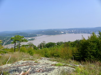 Once we hit the Ramapo Dunderberg Trail we turned right to go up and look at the mine pits near the top of the mountain. I noticed that even this minor gain in elevation was tiring especially in my legs. I considered the options and decided that the only viable one was to continue across the Dunderbergs. After looking at the pits, we turned around, headed back down the red trail to the junction with the blue Cornell Mine Trail. We headed right to stay on the red trail and began a short climb to regain some lost elevation. This was when I decided that having something to drink was a good idea! The first .25 miles from the junction ascends gently to the highest point on the Dunderberg Ridge. From this point on the trail generally descends but there are a few short ascents that left my muscles tired. Each time I though we had reached the last climb there was another small one. I kept drinking which seemed to help. There a few lookouts along the way but I was more interested in getting back to the car. In addition, the haze continued to hang around making pictures of scenery difficult to get. At about 5.3 miles we were on a long .4 mile descent which was followed immediately by the last significant climb. From 6.15 miles on the trail is down all the way. It was 2:15 PM when we started down. This descent is one of the worst sustained descents you I have ever experienced. The first part of the trail is narrow and well-used. This makes the erosion greater leaving a narrow channel to conduct water and promote erosion. On this trip there were a couple of blowdowns that did not help much. I did stop once to take a few pictures of the river before hurrying on. The trail flattens a little at 6.8 miles as it makes a turn to the southwest. Here we were walking along the large, angular stones that were sued to form the railroad bed on the side of the mountain. These stones make for difficult hiking. At 7.25 miles there is an abutment for the donkey engine that was going to be used to pull railroad cars to the hotel on top of the ridge. From this point down for the next .2 miles the trail is on the railroad bed with more ankle-breaking rocks. At 7.45 miles we were back at he trail junction where we had turned left earlier in the day. We continued down another short but difficult descent to the parking area. Along the way I did stopped to take pictures of the railroad tunnel. We ere back in the lot at 3:15 PM having covered our 7.8 mile hike in 5 hours which included several longer stops and a few shorter ones. On the way home Route 6 was stop and go traffic from the traffic circle over the mountain to the mall. On the way over Route 6 I began to get cramps in my legs and then sever cramps. I stopped at the parking area knowing I had only myself to blame. After some massage and the rest of the water, the cramps had subsided but the traffic had not. At the mall exit the police we blocking traffic and I could see an accident by the mall. This meant the mall traffic and those of us headed west on Route 17 were all in it together. After one or two exits there was a sign for mall parking and the traffic abated.
![]()
![]() On Thursday, September 1st Cindy and I wanted to get in a hike close to home so that we did not interfere with recovery and repair operations after Irene. We decided to head to Trout Pond north of Roscoe to see what the trails looked like...if we could get there. We headed north on the Quickway and got off at the Roscoe exit. As we drove across the Rockland flats, we did not see any evidence of flooding and little overall damage. Route 206 was open toward Downsville and there was no problem turning onto Morton Hill Road. This road has been washed out in every previous storm but showed no damage at all this time. We parked at the upper lot where Morton Hill and Russell Brook Roads meet at about 11:30AM and started our hike almost immediately. On our walk down Russell Brook Road we saw a few trees and large branches had come down but they all had been cleared off the road. As we passed the falls on the road I could not resist walking down to the viewpoint above the lower falls to take some pictures of the upper falls head on. Some of the trees that blocked the upper falls had been washed away and the upper falls looked very clean. The water volume was just right and the water was clear and not muddy. I took pictures before we walked down to the lower parking area. From this parking area we headed to the stream bed below the lower falls. I was surprised the water level wasn't any higher than it was and we were easily able to go down to the stream bed to walk to the base of the falls. I took more pictures at this point. We then decided to skip a trip up the left side of the falls and start our hike right away. At the trail register, where the trails split, we decided to bear left and hike the steeper part of the trail toward Mud Pond first. The next .7 miles of the hike is all uphill on a woods road and tops out just above Mud Pond.
On Thursday, September 1st Cindy and I wanted to get in a hike close to home so that we did not interfere with recovery and repair operations after Irene. We decided to head to Trout Pond north of Roscoe to see what the trails looked like...if we could get there. We headed north on the Quickway and got off at the Roscoe exit. As we drove across the Rockland flats, we did not see any evidence of flooding and little overall damage. Route 206 was open toward Downsville and there was no problem turning onto Morton Hill Road. This road has been washed out in every previous storm but showed no damage at all this time. We parked at the upper lot where Morton Hill and Russell Brook Roads meet at about 11:30AM and started our hike almost immediately. On our walk down Russell Brook Road we saw a few trees and large branches had come down but they all had been cleared off the road. As we passed the falls on the road I could not resist walking down to the viewpoint above the lower falls to take some pictures of the upper falls head on. Some of the trees that blocked the upper falls had been washed away and the upper falls looked very clean. The water volume was just right and the water was clear and not muddy. I took pictures before we walked down to the lower parking area. From this parking area we headed to the stream bed below the lower falls. I was surprised the water level wasn't any higher than it was and we were easily able to go down to the stream bed to walk to the base of the falls. I took more pictures at this point. We then decided to skip a trip up the left side of the falls and start our hike right away. At the trail register, where the trails split, we decided to bear left and hike the steeper part of the trail toward Mud Pond first. The next .7 miles of the hike is all uphill on a woods road and tops out just above Mud Pond.
 Near Mud Pond we turned right off the woods road and snowmobile trail and headed up to Cherry Ridge. For the next 1.1 miles the trail gains elevation to the shoulder of Cherry Ridge. The trail was in good shape with only a little erosion and some minor blowdowns. The effects of Tropical Storm Irene were less than some other recent heavy thunderstorms! The next .75 miles are a descent of 450 feet to the outlet end of Trout Pond. When we arrived, we found the outlet stream easily forded and the skies beginning to clear. I took some pictures and we stopped briefly for a snack before walking the flat trail along the shore to the outlet end. Here I took some more pictures with the now blue sky adding another dimension. A group of hikers arrived and we exchanged some greeting and discussed our hikes. When it was time to go, Cindy, Sheba and I headed down the woods road back to the trail register. After descending this .85 mile section, we stared the .6 mile ascent back up Russell Brook Road to our car. We were back by 2:30 PM taking almost exactly 3 hours for the 5.7 mile hike.
![]()
![]() On Tuesday, August 30th Karl and I left The Denning trail head and headed back out the Claryville Road. We turned left on Red Hill Road and went UP and over the hill. There was no blowdown or erosion and the road was in good shape. We turned right on Sugarloaf Road and it was much the same. At the Sundown Road we turned left and passed the baseball and softball fields. It was obvious that the fields had been under water and one looked playable with only a little clean up required. The other fields are littered with large trees and other debris. As we continued toward Sundown there were areas where it was obvious that water had washed across the road. In Sundown the road to Peekamoose and West Shokan was blocked and closed. We turned right to go to Yagerville. Along this part of the road there were many places where small creeks had obviously become raging torrents as parts of the road were washed away. All in all the damaged seemed no more than for the average flooding situation. The view to the Shawangunks was very nice as we started down the other side. I turned left onto Shalom Road and found a small tree hanging low. The rest of the road was chewed up but not much more than usual. We parked at 2:15 PM and hurried down to Trout Creek since Karl needed to get home.
On Tuesday, August 30th Karl and I left The Denning trail head and headed back out the Claryville Road. We turned left on Red Hill Road and went UP and over the hill. There was no blowdown or erosion and the road was in good shape. We turned right on Sugarloaf Road and it was much the same. At the Sundown Road we turned left and passed the baseball and softball fields. It was obvious that the fields had been under water and one looked playable with only a little clean up required. The other fields are littered with large trees and other debris. As we continued toward Sundown there were areas where it was obvious that water had washed across the road. In Sundown the road to Peekamoose and West Shokan was blocked and closed. We turned right to go to Yagerville. Along this part of the road there were many places where small creeks had obviously become raging torrents as parts of the road were washed away. All in all the damaged seemed no more than for the average flooding situation. The view to the Shawangunks was very nice as we started down the other side. I turned left onto Shalom Road and found a small tree hanging low. The rest of the road was chewed up but not much more than usual. We parked at 2:15 PM and hurried down to Trout Creek since Karl needed to get home.
 We walked along Shalom Road toward the top of the upper falls. The path that parallels the creek was in good shape and the one down to the creek bed was OK. I was surprised that there wasn't more water in the stream. The falls were flowing with good volume but we were able to stand where I always stand to take pictures. I shot a video more for the sound than the visual image. I took some pictures and then we headed back up the bank. We continued along the path and down to the top of the lower falls. Again, I shot a video and took some pictures. We looked at the old foundations at the bottom of the falls. I walked down to the creek bed and took some more pictures. Since we were under a time constrain, we headed back up the bank to the old road and back to the car. It was 2:45 PM when we got back to the car and headed home.
![]()
![]() On Tuesday, August 30th Karl and I wanted to get out an hike and inspect the post-Irene situation. I was concerned about staying out of the way of the roads crews working to repair the roads and wanted to stay away from the most seriously effected areas. We decided to stay local and head for the Denning trail head since I wanted to check out the bridges across The east Branch of the Neversink and Deer Shanty Brook. If we had time, I planned to go to Angel Falls in Yagerville to check out the volume of flow. We headed out the DeBruce Road from Livingston Manor at about 11;30 AM and had no trouble until we got to Route 47, the Frost Valley Road. The road was blocked going in the direction of Frost Valley and with good reason. The West Branch of the Neversink had undermined the road and only the left lane looked passable but not necessarily safe! We were turning right anyway to head toward Claryville. A large bus was parked almost in the middle of the road with the passengers unloading and loading luggage. No one seemed concerned that others wanted to pass so I eventually asked the fire police if we could get by. We seemed a little surprised but said "Sure". The bridges near Claryville seemed in good shape and we turned left on the Claryville road with seeing much damage. I checked with a DPW worker in town and he told us the road to the trail head was "open but rough". The further we drove the worse it got. Pavement was undermined and missing and there were some sinkholes. Where the road turns to dirt sections were washed out and had been filled in by the road crews. The sections around the Straus House and New Hill Road were very bad. There were no crews working in the area so I did not feel bad about driving to the trail head. We arrived at the Denning parking area just before noon and started to hike shortly after. There we people at the Tisson house and the house and trail head seemed in good shape.
On Tuesday, August 30th Karl and I wanted to get out an hike and inspect the post-Irene situation. I was concerned about staying out of the way of the roads crews working to repair the roads and wanted to stay away from the most seriously effected areas. We decided to stay local and head for the Denning trail head since I wanted to check out the bridges across The east Branch of the Neversink and Deer Shanty Brook. If we had time, I planned to go to Angel Falls in Yagerville to check out the volume of flow. We headed out the DeBruce Road from Livingston Manor at about 11;30 AM and had no trouble until we got to Route 47, the Frost Valley Road. The road was blocked going in the direction of Frost Valley and with good reason. The West Branch of the Neversink had undermined the road and only the left lane looked passable but not necessarily safe! We were turning right anyway to head toward Claryville. A large bus was parked almost in the middle of the road with the passengers unloading and loading luggage. No one seemed concerned that others wanted to pass so I eventually asked the fire police if we could get by. We seemed a little surprised but said "Sure". The bridges near Claryville seemed in good shape and we turned left on the Claryville road with seeing much damage. I checked with a DPW worker in town and he told us the road to the trail head was "open but rough". The further we drove the worse it got. Pavement was undermined and missing and there were some sinkholes. Where the road turns to dirt sections were washed out and had been filled in by the road crews. The sections around the Straus House and New Hill Road were very bad. There were no crews working in the area so I did not feel bad about driving to the trail head. We arrived at the Denning parking area just before noon and started to hike shortly after. There we people at the Tisson house and the house and trail head seemed in good shape.
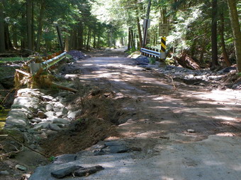 As we walked out the trail there were some wet spots abut not too much erosion. There was some blowdown but it was not excessive until we got to the new bridge across a small creek. There were several large limbs blocking the trail just before the bridge although the bridge was untouched. By 12:30 PM we had hiked the 1.25 mile stretch of trail to the turn off for the trail to Table. We turned right and headed for the river. Again, the trail was in good shape and by 12:35 PM we were at the first bridge. The bridge is in poor shape and may be passable but is not safe. The near caisson had been damaged during previous high water. It now is "hanging" with almost all of the rocks gone. The steps are non-existent and the wings are twisted or missing. The steel I beams appear intact. I walked downstream and took some pictures of the bridge. To get on the bridge I walked along the upstream wing and the logs piled against the caisson. Walling across the bridge was "interesting" and I stopped to take a few pictures in both directions. The bridge structure on the far side seemed undamaged with rocks filling the caisson. I took a few pictures here and then walked over to the log bridge. This two log structure is higher above the water and was completely untouched. There was a large tree hanging low over the near end but otherwise there were no signs of nay problems. I walked back to Karl and the dogs and crossed back over the bridge. We headed back and were at the car by 1:30 PM. On the way out we stopped several times OS that I could take pictures of the road. The pictures don't really do justice to the damage. As we approached Red Hill Road, we decided to see if we could get over the hill to Sugarloaf Road which is the fastest way to Yagerville.
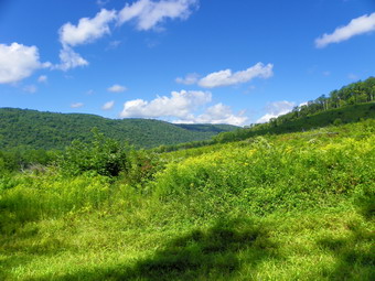
![]()
![]() On Friday, August 26th Cindy and I wanted to do another "local" hike and decided to head to Bear Spring State park north of Walton. The park has many snowmobile and horse trails that are wide and grassy. The trail have a good surface and there Rae no major mountains but the climbs to the ridges can be challenging. I planned a route from a parking area on East Trout Brook Road up to the ridge and then looping to near Launt Pond and then back to the car. I drove to Roscoe and then took County Route 206 through Downsville to the top of Bear Spring Mountain near Walton, NY. I turned right on East trout Brook Road and drove south passed Launt Pond for another 1.3 miles further. I parked on the left side of the road in the parking area at about 11:45 AM and we got right on the trail. We walked down the wide path/road and across the dam that creates the small pond. At the trail junction we found three horseback riders. Although the park is one of the few constructed with horses in mind, this was the first time I had seen riders. We talked for a moment and then we continued straight ahead up the hill on the wide grassy snowmobile/horse trail. There are a few trail on the left and the one we were on did not look familiar. I began to wonder if I had picked the correct trail! It proved to be the right trail and just looked unfamiliar since I had only been on it once and that was traveling in the other direction. Soon the horses caught up with us and passed by. At least one of the horses gave Sheba, who was sitting quietly by my side, a wide-eyed look. The trail climbed steadily toward the ridge. At .35 miles a trail marked "New Trail" came in on the left and it must have been new since I did not recall it being there on earlier trips. We continued straight ahead to a trail junction at .68 miles. We could see the horses climbing the trail just ahead but we stopped to take some pictures at the base of a clear cut. There are several of these areas in the park and I have not spoken to anyone who knows exactly why they are being done! I took some pictures of the green vegetation against the blue sky with white clouds.
On Friday, August 26th Cindy and I wanted to do another "local" hike and decided to head to Bear Spring State park north of Walton. The park has many snowmobile and horse trails that are wide and grassy. The trail have a good surface and there Rae no major mountains but the climbs to the ridges can be challenging. I planned a route from a parking area on East Trout Brook Road up to the ridge and then looping to near Launt Pond and then back to the car. I drove to Roscoe and then took County Route 206 through Downsville to the top of Bear Spring Mountain near Walton, NY. I turned right on East trout Brook Road and drove south passed Launt Pond for another 1.3 miles further. I parked on the left side of the road in the parking area at about 11:45 AM and we got right on the trail. We walked down the wide path/road and across the dam that creates the small pond. At the trail junction we found three horseback riders. Although the park is one of the few constructed with horses in mind, this was the first time I had seen riders. We talked for a moment and then we continued straight ahead up the hill on the wide grassy snowmobile/horse trail. There are a few trail on the left and the one we were on did not look familiar. I began to wonder if I had picked the correct trail! It proved to be the right trail and just looked unfamiliar since I had only been on it once and that was traveling in the other direction. Soon the horses caught up with us and passed by. At least one of the horses gave Sheba, who was sitting quietly by my side, a wide-eyed look. The trail climbed steadily toward the ridge. At .35 miles a trail marked "New Trail" came in on the left and it must have been new since I did not recall it being there on earlier trips. We continued straight ahead to a trail junction at .68 miles. We could see the horses climbing the trail just ahead but we stopped to take some pictures at the base of a clear cut. There are several of these areas in the park and I have not spoken to anyone who knows exactly why they are being done! I took some pictures of the green vegetation against the blue sky with white clouds.
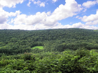 When I was done photographing, we turned right and continued climbing until the trail junction at 1.23 miles. Here we turned left up the hill to the ridge. At 1.61 miles into the hike we were at the top of the ridge. It was 12:30 PM and we stopped briefly for a drink and a snack. The trail began "roll" along the ridge with only a few ups and downs. It was in this area that we began to encounter some REALLY wet spots. The rain the night before had created some marshy and muddy places. The trail started to turn from east to northwest at about 1.85 miles and we passed by the trail to Downsville on the right. Soon the horses were headed in our direction again and we passed each other without indent. At 3.0 miles we passed by the turn to the left through a field. This trail leads back to the trail junction at the base of the clear cut and is a good "early out". We continued straight ahead to 3.33 miles and turned left down another wide trail. I thought this was the trail I had used to come up to the ridge from Launt Pond one time but it was actually another woods road or horse trail. The trail initially headed south but them went through a switchback that turned northwest. As we descended, there were some limited views on the left side of the trail. The trail surface was good but I could tell from the GPS and my own recollection that this was a different route than I had taken before. By 1:45 PM we arrived at a parking area on East Trout Brook Road 4.6 miles into the hike. Just to the right was the trail head for the trail up to the ridge from the pond! I had planned to walk the road about .8 miles back to the car but noticed the sign that said "new Trail". Having remembered the sign from earlier we decided to avoid the road walk by taking the trail. We made a sharp left turn onto the trail which started a short but brief climb, The trail took us passed ANOTHER clear cut area. The temperature by this time was in the high seventies and it was humid. The trail parallel the brook and road for a while and then veered left and began to climb. I started to wonder if this was the right trail! At 5.65 miles the trail hit its apex and started down passing the clear cut area from earlier in the day. After walking 1.3 miles on the trail, we reached the trail junction at 5.9 miles and turned right to walk back to the dam and across the top to the car. We covered the 6.3 miles in 2 hours and 40 minutes.
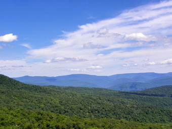
![]()
![]() On Wednesday, August 24th Cindy and I had planned to hike Schunemunk but got a call to baby-sit the grandson in the evening. We decided that we would go to Giant Ledge since it is close and has a view. The temperature was in the low 70's with not too much humidity so the conditions seemed ideal. On the way to the trail head we got stuck behind a crew painting the lines on Route 47 so we did not arrive until just before noon. There were a couple of cars at Dry Brook, a few more at Slide and two or three at the parking for Giant Ledge and Panther. We walked across the road and I signed the register so that we could get going. On the way up to the trail junction we met a couple coming down from Giant Ledge and a young man who had been up to Panther and back. The trail was wet in places but some had been through to clean out all the water bars and did some other maintenance. The trail gets a lot of traffic and is eroded in spots. It has always been very rocky! By 12:20 PM we had walked the .75 miles to the trail junction and turned left to go up to the Ledges. I could feel the 10 mile hike from the day before in every step up. At 12:50 PM we had climbed the last steep section and were at the first of the lookouts. As we were making our way up the steep ascent, we met another couple coming down.They had been to the Ledges to eat lunch and were now returning. We talked for a moment and then went in opposite directions.
On Wednesday, August 24th Cindy and I had planned to hike Schunemunk but got a call to baby-sit the grandson in the evening. We decided that we would go to Giant Ledge since it is close and has a view. The temperature was in the low 70's with not too much humidity so the conditions seemed ideal. On the way to the trail head we got stuck behind a crew painting the lines on Route 47 so we did not arrive until just before noon. There were a couple of cars at Dry Brook, a few more at Slide and two or three at the parking for Giant Ledge and Panther. We walked across the road and I signed the register so that we could get going. On the way up to the trail junction we met a couple coming down from Giant Ledge and a young man who had been up to Panther and back. The trail was wet in places but some had been through to clean out all the water bars and did some other maintenance. The trail gets a lot of traffic and is eroded in spots. It has always been very rocky! By 12:20 PM we had walked the .75 miles to the trail junction and turned left to go up to the Ledges. I could feel the 10 mile hike from the day before in every step up. At 12:50 PM we had climbed the last steep section and were at the first of the lookouts. As we were making our way up the steep ascent, we met another couple coming down.They had been to the Ledges to eat lunch and were now returning. We talked for a moment and then went in opposite directions.
 At the first lookout, we stopped for some time while Cindy and I both took pictures and got a drink. I wandered over to the big Rock that sometimes acts as a campsite and found a path along the cliffs with several small viewpoints. After walking a short distance, I decided to go back to Cindy. After a few more pictures, we walked to the next major lookout and I took some more pictures. There was some haze hanging in the valley and over the Burroughs Range and the other mountains. Despite the haze there were many interesting clouds and I felt I got some good pictures. I had suggested going down into the col and bushwhacking through the bog but Cindy was not enthusiastic. After thinking about the bushwhack, I began to see the wisdom in staying away from a bog just after heavy rain! We started back at 1:15 PM walking the trail to the first lookout and decided to follow the path I had found earlier. We didn't have to go very far as it quickly returned to the main trail. The trip down went quickly although some of the rocky areas slowed us down. On one of the last rocky areas we met a group of young hikers coming toward us. They looked like they were having a great time. Further down I looked up and saw the couple we had met near the top. We caught and passed by them on our way back to the trail register. I signed out and we were back at the car by 2:10 PM having covered the 3.5 mile distance in 2 bouts and 0 minutes including our stops.
![]()
![]() On Tuesday, August 23rd I wanted to do a hike after cross country practice but did not want to drive too far. I considered Slide or Panther but decided to head for Long Pond. I wanted to hike from Flugertown Road to Mongaup Pond and back in a loop of almost 10 miles. This is a pretty walk through the woods without too many viewpoints. I does have some elevation gain, to about 3100 feet, and interesting rock ledges. Sheba and I arrived at the trail head just after 11:15 AM. The road is paved for some distance and then has a gravel and rock surface. This gets pretty rough in places but is passable. I parked just after the trail head and before the bridge. We were on the trail by 11;25 AM. At this point the red Long Pond-Beaverkill trail, yellow Mongaup-Willowemoc Trail and a snowmobile trail are co-aligned. In the first .45 miles the trail gains over 200 feet of elevation and continues to head up for a good distance. At this point we turned right to stay on the red Long Pond-Beaverkill Trail. This trail is not used very much and was overgrown with prickers and nettles in places. At about .7 miles the trail levels some but only for about .25 miles before it climbs again. For the next .6 miles the trail gains 450 feet and then again levels for a short period. Everything was very green with moss on most of the rocks and trees. I was surprised by the amount of blowdowns along the trails. Some of these were old and some new. A few showed some ax work by trail maintainers but others will need a chainsaw to clear them. At just over 2.9 miles the red trail meets the blue Mongaup-Hardenburgh Trail. Just before the trail junction I was surprised to see three young men hiking toward us. We exchanged greetings and passed by each other. I don't ever remember meeting anybody on this trail!
On Tuesday, August 23rd I wanted to do a hike after cross country practice but did not want to drive too far. I considered Slide or Panther but decided to head for Long Pond. I wanted to hike from Flugertown Road to Mongaup Pond and back in a loop of almost 10 miles. This is a pretty walk through the woods without too many viewpoints. I does have some elevation gain, to about 3100 feet, and interesting rock ledges. Sheba and I arrived at the trail head just after 11:15 AM. The road is paved for some distance and then has a gravel and rock surface. This gets pretty rough in places but is passable. I parked just after the trail head and before the bridge. We were on the trail by 11;25 AM. At this point the red Long Pond-Beaverkill trail, yellow Mongaup-Willowemoc Trail and a snowmobile trail are co-aligned. In the first .45 miles the trail gains over 200 feet of elevation and continues to head up for a good distance. At this point we turned right to stay on the red Long Pond-Beaverkill Trail. This trail is not used very much and was overgrown with prickers and nettles in places. At about .7 miles the trail levels some but only for about .25 miles before it climbs again. For the next .6 miles the trail gains 450 feet and then again levels for a short period. Everything was very green with moss on most of the rocks and trees. I was surprised by the amount of blowdowns along the trails. Some of these were old and some new. A few showed some ax work by trail maintainers but others will need a chainsaw to clear them. At just over 2.9 miles the red trail meets the blue Mongaup-Hardenburgh Trail. Just before the trail junction I was surprised to see three young men hiking toward us. We exchanged greetings and passed by each other. I don't ever remember meeting anybody on this trail!
 At the trail junction we turned left to head to Mongaup Pond. It was about 12:43 PM. Over the next .7 miles the trail dips and then rises causing the elevation profile to look like a roller coaster! At 3.6 miles the trail descends sharply for 370 feet only to ascend 420 feet again to another peak of labeled Mongaup Mountain! Over the next 1.6 miles the trail descents almost 800 feet to the shores of Mongaup Pond. The trail continues to the right to the park roads. We stopped briefly so that I could take pictures of the pond and some ducks near the shore. The time was around 2:19 PM. We then turned left of the snowmobile trail to walk clockwise around the pond to pick up the yellow Mongaup-Willowemoc Trail. After less than .5 miles, we turned left on the yellow trail to head back to Flugertown Road. Over the next .65 miles the trail gained about 250 feet but this was the last ascent. There are several bridges along the way and at least one turn off the trail to a snowmobile loop. At 8.3 miles we crossed Butternut Creek, the outlet to Sand Pond. From here the trail becomes mostly a woods road for the next .9 miles where it meets the Long Pond-Beaverkill Trail again. This part of the trail first passes through a stand of large evergreens. From there the trail becomes wetter with some standing and running water. At the trail junction we turned right and headed back down to the car. We arrived at 3:55 PM covering the 9.8 mile sin 4.4 hours. After turning onto Willowemoc Road and passing the campgrounds, I noticed three hikers up ahead. As I pulled along side them, I realized it was the three young men I had met on the trail. They were trying to get back to their car at the start of the Mongaup-Hardenburgh Trail on the Beaverkill Road! There are certainly routes that accomplish this but it was late in the day so I offered to give them a ride. They piled into the car and I was glad they didn't mind Sheba and that Sheba seemed content with them in the car. They were very interesting and polite young men. I found out they are all volunteer fire fighters on Long island and proud of it! We exchanged stories as I drove them to the hunting camp where they were staying on Alder Creek Road. I hope to see them again some time.
![]() On Saturday, August 20th Jeff Senterman, the new Catskill Regional Program Coordinator for the New York-New Jersey Trail Conference, was visiting Morgan Outdoors in Livingston Manor. After a met and greet from 1:00 AM to 2:00 PM, Jeff led a hike at Frick Pond. We all met at the parking area at the end of Beech Mountain Road and then started up the Flynn Trail. Before the junction WI the Big Rock Trail, we took a brief off-trail excursion to the Mystery Clearing. Back on the Flynn Trail, we walked to the junction and then headed Dow the Big Rock Trail to Times Square. We continued straight ahead around the back of Frick Pond to the outlet. From the bridge at the outlet we took the Quick Lake Trail back to the parking area. The hike of a little more than 4 miles took us a little over 2 hours.
On Saturday, August 20th Jeff Senterman, the new Catskill Regional Program Coordinator for the New York-New Jersey Trail Conference, was visiting Morgan Outdoors in Livingston Manor. After a met and greet from 1:00 AM to 2:00 PM, Jeff led a hike at Frick Pond. We all met at the parking area at the end of Beech Mountain Road and then started up the Flynn Trail. Before the junction WI the Big Rock Trail, we took a brief off-trail excursion to the Mystery Clearing. Back on the Flynn Trail, we walked to the junction and then headed Dow the Big Rock Trail to Times Square. We continued straight ahead around the back of Frick Pond to the outlet. From the bridge at the outlet we took the Quick Lake Trail back to the parking area. The hike of a little more than 4 miles took us a little over 2 hours.
![]()
![]() On Thursday, August 18th Karl and I had finished hiking Falls Creek at around 1:00 PM and decided to head north to Mount Pisgah State and County Park about 11 miles north. The first challenge was to figure out the best route. The map we were using had few of the back roads and we weren't sure whether some of the were dead ends or had surfaces incompatible with modern vehicles. We decided to go back out to Powell and find a road north from there. The best that can be said is that we did get to the park but that the route was not exactly direct. Along the way we saw several areas with two or three green tanks in a field. At first I thought they might provide water for the cows but then we took a closer look. The signs read something like "Energy Resources Company". We realized that these were well sunk into the underlying Marcellus shale to extract natural gas. Our first impression was "That's not so bad." followed quickly by the realization of what had to be done to release the gas. We parked in the lot next to Stephen Foster Lake at the state park at around 2:00 PM. The lake is formed by a dam on Mill Creek and we started our hike by crossing the road and getting on the Mill Creek Trail. The first .4 miles of the trail was a little uphill and both Karl and I realized our legs were tired. We stayed left on a snowmobile trail at a junction and soon arrived at the Ridge trail. We were happy that the trails were all marked with wooden signs. We were surprised that the trails were being mowed. After a short distance on the Ridge Trail it began to climb through a forest with one or two marked trails crossing the main trail. At one point we walked in a field beside some filed corn and then back into the woods. Every so often a bench appeared along the trail.
On Thursday, August 18th Karl and I had finished hiking Falls Creek at around 1:00 PM and decided to head north to Mount Pisgah State and County Park about 11 miles north. The first challenge was to figure out the best route. The map we were using had few of the back roads and we weren't sure whether some of the were dead ends or had surfaces incompatible with modern vehicles. We decided to go back out to Powell and find a road north from there. The best that can be said is that we did get to the park but that the route was not exactly direct. Along the way we saw several areas with two or three green tanks in a field. At first I thought they might provide water for the cows but then we took a closer look. The signs read something like "Energy Resources Company". We realized that these were well sunk into the underlying Marcellus shale to extract natural gas. Our first impression was "That's not so bad." followed quickly by the realization of what had to be done to release the gas. We parked in the lot next to Stephen Foster Lake at the state park at around 2:00 PM. The lake is formed by a dam on Mill Creek and we started our hike by crossing the road and getting on the Mill Creek Trail. The first .4 miles of the trail was a little uphill and both Karl and I realized our legs were tired. We stayed left on a snowmobile trail at a junction and soon arrived at the Ridge trail. We were happy that the trails were all marked with wooden signs. We were surprised that the trails were being mowed. After a short distance on the Ridge Trail it began to climb through a forest with one or two marked trails crossing the main trail. At one point we walked in a field beside some filed corn and then back into the woods. Every so often a bench appeared along the trail.
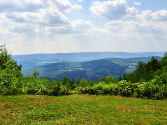 We continued to walk through open places and then back into forest. The trail would flatten some in places and then climb toward the summit. At one point we looked out and saw how far we had to go and it was discouraging. The trail finally dipped a little and at 2.9 miles we turned right onto the road to the county park. This paved road took us all the way to the summit passed several viewpoints on the way. As it flattened near the top there were some facilities and primitive campsites but everything looked unmaintained and seemed to be in disrepair. We continued to the summit which has a pavilion and two communications towers. It was 3:15 PM and we had covered 3.3 miles. In the area facing west there was a nice viewpoint with some benches. The skies were cloudy at this point with some haze but this reminded us how lucky we had been that it had not rained. I took some pictures and then we started back. A sign on the pavilion described a lodge and observation tower that once stood on the summit. On the way back we stopped at some of the other lookouts so that I could take some pictures and then hurried our walk down the trail. At the last trail junction we headed right on the Ridge Trail down to the road and crossed to the other side. We picked up the Oh! Susanna Trail around Stephen Foster Lake and we were back at the car by 4:30 PM covering 6.6 miles in just over 2.5 hours. Karl and I wanted to check the road that accesses the county park to see if it was closed or open. Somewhere along the way we missed the turn but the county website only has regulations for last year! On the way back to Route 220 we saw many more gas wells. The site made us a little angry and very sad.
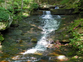
![]()
![]() On Thursday, August 18th Karl agreed to meet me in Livingston Manor to go hiking. I had been planning to return to Pennsylvania and hike one of the creeks with waterfalls. I find waterfalls very interesting and had been reading a number of trail guides that describe various trails and hikes in the northeastern and north central parts of the state. I decided to try hiking Falls Creek which has three major falls plus other interesting features. There is no trail and choosing the right water level can be tricky. Too much water makes hiking up the creek bed dangerous and tricky but too little water means the falls are not interesting. The weather report had changed from bright and sunny to a 50% chance of thunderstorms. When I got out of bed at 6:00 AM it was raining and totally overcast.I decided that we would go anyway since the trip was around 3 hours and the weather where we were going could be acceptable. Karl arrived a little after 7;00 AM and we started the drive. Finding the correct place to park was the first challenge. We took State Route 17 north and west through Binghamton to Waverley. At Waverley we headed south on State Route 220 through Towanda to Monroeton. Here we turned west on Route 414 to a small town called Powell. We were looking for a right onto Main Street but could not find it. We turned around and headed back. From the description in the guide book, we knew where to turn. The turn was labeled Brocktown Road with no Main Street designation. After turning we crossed two bridges and turned right onto Weston Road determined to stay along Schrader Creek which was on our right. When the road forked we stayed to the right. The description said there was a small parking area on the right just before a narrow cement bridge. The road quickly turned to chipped stone and dirt and we saw signs for Game Lands 36. When we got to the stone bridge we had only traveled a little over 4 miles while the book said it was around six miles. I elected to continue on and at around six miles we found the SECOND stone bridge with the parking area. I parked and we were on the trail by 10:20 AM.
On Thursday, August 18th Karl agreed to meet me in Livingston Manor to go hiking. I had been planning to return to Pennsylvania and hike one of the creeks with waterfalls. I find waterfalls very interesting and had been reading a number of trail guides that describe various trails and hikes in the northeastern and north central parts of the state. I decided to try hiking Falls Creek which has three major falls plus other interesting features. There is no trail and choosing the right water level can be tricky. Too much water makes hiking up the creek bed dangerous and tricky but too little water means the falls are not interesting. The weather report had changed from bright and sunny to a 50% chance of thunderstorms. When I got out of bed at 6:00 AM it was raining and totally overcast.I decided that we would go anyway since the trip was around 3 hours and the weather where we were going could be acceptable. Karl arrived a little after 7;00 AM and we started the drive. Finding the correct place to park was the first challenge. We took State Route 17 north and west through Binghamton to Waverley. At Waverley we headed south on State Route 220 through Towanda to Monroeton. Here we turned west on Route 414 to a small town called Powell. We were looking for a right onto Main Street but could not find it. We turned around and headed back. From the description in the guide book, we knew where to turn. The turn was labeled Brocktown Road with no Main Street designation. After turning we crossed two bridges and turned right onto Weston Road determined to stay along Schrader Creek which was on our right. When the road forked we stayed to the right. The description said there was a small parking area on the right just before a narrow cement bridge. The road quickly turned to chipped stone and dirt and we saw signs for Game Lands 36. When we got to the stone bridge we had only traveled a little over 4 miles while the book said it was around six miles. I elected to continue on and at around six miles we found the SECOND stone bridge with the parking area. I parked and we were on the trail by 10:20 AM.
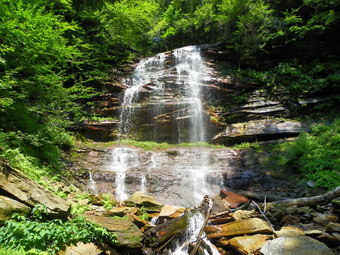 The water in Falls Creek drains from a plateau with an elevation of just under 2000 feet. Our starting elevation was about 1200 feet. In 1812 coal was discovered on top of the plateau. By 1856 the coal was being commercially mined and the town of Barclay was well-established on the plateau. After the coal ran out, the area became a center for logging and tanning. Most of the large hemlock forests were removed to feed this industry centered at the town of Laquin on Schrader Creek. Due to all this industry the waters of Falls Creek like many in the area are highly acidic. To counteract the acidity the state had built a water treatment facility on the creek just before the water flows into Schrader Creek. A dam diverts water through a cistern filled with limestone. The water turns a device that grinds the limestone which then dissolves in the water to neutralize the acid. The rocks in the upper part of the creek have a distinctive orange tint from the acid but those in the lower part show almost no discoloration. The guidebook said that the hike was only about 2 miles but that it could take over 3 hours to complete. The water level was low but there was still some volume and I hoped we had hit it just right! We were able to hike up the creek bed pretty easily as long as we were willing to cross back and forth. We let the water level and the steepness of the banks dictate our path. Initially there were only a few small rapids and then some falls with drops of six to twelve feet. They were pretty and I took pictures but I was getting a little nervous. It occurred to me we might be on the wrong creek or that the books exaggerated the heights of the falls. We kept hiking and soon passed three rather substantial falls as the book had stated. Up ahead Karl informed me that there was a larger falls in view. At only .65 miles but almost and hour into the hike we arrived at Bradford Falls.
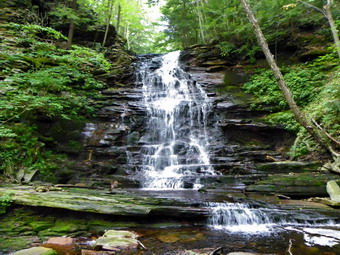 Bradford Falls is ENORMOUS compared to the ones below it! The books give the height as 100 feet and I would say it IS at least 70 feet tall. The water drops over the edge into a pool and the falls is bordered by the high stone walls of an impressive gorge. We worked our way up the creek bed and were able to stand at the base of the falls. I took many pictures and then we faced our next challenge? How were we to get out of the gorge to continue the hike upstream? Karl decided on the most direct route which was a STEEP climb up the slippery bank less than a 100 feet from the base of the falls. The three of us took turns route finding. Karl and I used some trees to pull ourselves up while Sheba relied on four paw drive! When we reached the top of the climb, we looked back down. It seemed as if the route dropped straight down! We walked along the high ground briefly before descending back to the creek. I took some pictures from the top of Bradford Falls before walking upstream to the next falls. Just above Bradford Falls is Barclay Falls. This waterfall is not as high as the one below but has a higher volume of water or at least a tighter chute. I took pictures here and then we repeated the climb back up to the higher ground. Another descent brought us to an area above a series of cascades and chutes on the creek below. I REALLY wanted to get down to photograph this area. I tried to inch down the steep bank but there was no safe way to get down to the creek bed. I decided to be safe and we once again climbed up the bank. After another short walk, I again started to work my way down a steep bank toward another cascade. Karl decided to stay up top with Sheba. Sheba doesn't like to be separated from me and puts up quite a fuss.
 I made it down the steep bank to a more level area. In front of me was a ten foot cascade and I took some shots. I walked along a little path as I headed upstream. Above I could see Sheba wanting to get down to me. I also saw several routes out of the gorge. Ahead on the creek I caught a glimpse of another falls. As I approached, I was sure the falls matched the description of Laquin Falls mentioned in the guidebook. I got closer so that there was no vegetation in front of me. The water passes over a receding ledge and splits to form at least two streams of water. The flow is not great as it is high on the creek but the falls is interesting. I took some shots and then worked my way out of the gorge to meet Karl and Sheba at the top. The stream was almost flat at this point with a greatly reduced volume of water. We were at 1850 feet and near the top of the plateau. We had hiked 1.1 miles in two hours! We decided to return to the car on the west bank and crossed the stream. For a short time we bushwhacked downstream looking for a road. Karl found the road and we turned left to walk downstream. The road became more defined as we went and soon we were back at the car. The return trip had taken just a little over 30 minutes. We completed our 2.3 mile adventure in just 2.5 hours! We were tired but thought we might get in another hike so we headed for Mount Pisgah State and County Parks almost directly north of Falls Creek by about 11 miles "as the crow flies".
![]()
![]() On Wednesday, August 17th Cindy and I were looking for a little exercise close to home so we decided to head to the area around Frick and Hodge Ponds. The plan was to hike up the Flynn Trail and then take the snowmobile trail to Mongaup Pond. We would return by way of the park and town roads to the car. We parked at the lot at the end of Beech Mountain Road just after 11:00 AM and crossed the road to pick up the blue Flynn Trail. We both remarked that this trail always seems long no matter the direction we hike or the season. On the way up we came across the same pile of logs at about 1.15 miles that we always pass. Each time we pass these logs which have had the bark removed, I ask myself why they are there. It is also possible to see some light up and behind the logs and I have always wanted to check out whether there is a viewpoint. Today was the day. I struck out up the steep but short bank and walked a short distance to find...a field. The field was very green and damp in most places. The flora looked like the kind you would find in a bog with many mosses. The soil was only a few inches deep since much of the field had an underlying rock layer close to the surface. I called Cindy to come up to take a look at this beautiful location. I took pictures and we both walked around the field exploring. Cindy found a road on the south side and we decided to follow it. I first complete my loop around the field to find it was about .2 miles in circumference. We followed the road hoping it would lead over the hill to Mongaup Pond but it only curved back toward the Flynn Trail ending up at the log pile. I suggested that we bushwhack over to Mongaup Pond knowing that my wife HATES bushwhacking. To my surprise she said "Yes!" and we were off.
On Wednesday, August 17th Cindy and I were looking for a little exercise close to home so we decided to head to the area around Frick and Hodge Ponds. The plan was to hike up the Flynn Trail and then take the snowmobile trail to Mongaup Pond. We would return by way of the park and town roads to the car. We parked at the lot at the end of Beech Mountain Road just after 11:00 AM and crossed the road to pick up the blue Flynn Trail. We both remarked that this trail always seems long no matter the direction we hike or the season. On the way up we came across the same pile of logs at about 1.15 miles that we always pass. Each time we pass these logs which have had the bark removed, I ask myself why they are there. It is also possible to see some light up and behind the logs and I have always wanted to check out whether there is a viewpoint. Today was the day. I struck out up the steep but short bank and walked a short distance to find...a field. The field was very green and damp in most places. The flora looked like the kind you would find in a bog with many mosses. The soil was only a few inches deep since much of the field had an underlying rock layer close to the surface. I called Cindy to come up to take a look at this beautiful location. I took pictures and we both walked around the field exploring. Cindy found a road on the south side and we decided to follow it. I first complete my loop around the field to find it was about .2 miles in circumference. We followed the road hoping it would lead over the hill to Mongaup Pond but it only curved back toward the Flynn Trail ending up at the log pile. I suggested that we bushwhack over to Mongaup Pond knowing that my wife HATES bushwhacking. To my surprise she said "Yes!" and we were off.
 Cindy can navigate by using the sun alone but I have to rely on my compass. We walked back up to the field and then headed across into the woods on an easterly course. The first part was flat and the woods mostly open. There we a few paths that looked like roads and one or two stone walls. Within .1 miles we started down through some AWESOME ledges! We dropped almost 500 feet in .5 miles. After one steep descent, we would be on a flat spot with another drop right in front of us. We allowed Sheba to pick most of the lines down through the ledges. The steep descent, sheer rock faces and verdant green moss made this a wonderful experience. (Cindy had other words to describe it!) Near the bottom of the ledges, as we approached the park roads around the pond, we ran into some woods roads. We arrived at the edge of the pond at 12:55 PM. Once on the park roads we had planned to turn right toward the entrance and walk the roads back to the car. I expressed my distaste for the walking on the roads. I suggested we walk to the next loop and take the snowmobile trail back over the mountain to the Flynn Trail and then back to the car. I was again surprised when Cindy agreed and we were off. We did have a drink and a snack by the pond as I took a few pictures.
 At the next campground loop we turn to the left and easily found the snowmobile trail. Cindy pointed out that we would have to gain the elevation we had lost from the Flynn Trail and then some. Of course, she was right. The snowmobile trail started to climb almost immediately. It was quite wide in most places but we immediately hit a low swampy area with water on the trail. It was easy to pick our way around this and we continued the hike. As the trail continued to climb many areas looked more like a stream bed as water flowed freely down the trail. In the more level spots the water pooled top form small ponds. We climbed for 1.85 miles gaining almost 700 feet to the highest point on the hike at over 2800 feet. From here we started a descent to the Flynn Trail which we hit at about 2:15 PM. From here it was the long familiar descent down the Flynn Trail to the parking area. The distance from the Big Rock Trail junction is about 1.7 miles and drops around 600 feet. We were back at the car by 2:55 PM having covered 7 miles in 3 hours and 50 minutes.
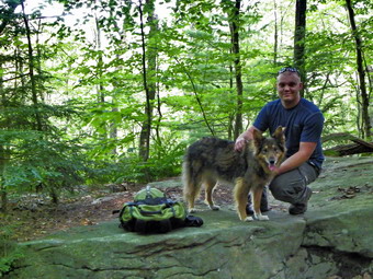
![]()
![]() On Friday, August 12th we were in Montgomery, Pennsylvania to help Krista and Brad begin remodeling their new home. Of course, I couldn't resist getting in at least one day of hiking so Brad and I headed to the beginning of the Loyalsock Trail to hike the first 5 miles or so. The Loyalsock trail starts on Route 87 northeast of Montoursville and stretches 60 miles to World's End State Park. It is maintained by a dedicated group of volunteers from the Alpine Club of Williamsport. The trail is well maintained and blazed with an LT over its entire length. The markers used to be can lids painted red with a yellow LT but are now custom plastic yellow markers with a red LT. Each mile from the beginning of the trail is also denoted at the closest markers. The first part of the trail takes in Sock Rock and was touted in the guidebooks to have some great views. This is because this section of trail ascends from the valley to the Allegheny Front and then follows this high ridge for several miles. We drove north from Montgomery on I180 and then got on Route 87 north in Montoursville. The trail head parking is on the side of the road about 8.8 miles from the I180 interchange. We parked at around 10:15 AM and got ready to hike. What most of the guidebooks do not emphasize is that the hike is STEEP right from the start. This is not a hike that has any warm up but one that will get your blood pumping immediately. After .4 miles the trail turns right as it meets an old woods road and there is a brief respite. Almost immediately the trail turns left off the road and up the ridge. A little further up the trail is a limited lookout on the right side of the trail where we stopped so that I could take a few pictures before continuing. The overall .6 mile section to Sock Rock is an average of a 29% grade! We arrived at this famous point around 10:45 AM. There are some impressive ledges along the way but Sock Rock itself didn't look much like a sock and there was no view! The trail turns right after Sock Rock but continues to climb steeply for another .25 miles.
On Friday, August 12th we were in Montgomery, Pennsylvania to help Krista and Brad begin remodeling their new home. Of course, I couldn't resist getting in at least one day of hiking so Brad and I headed to the beginning of the Loyalsock Trail to hike the first 5 miles or so. The Loyalsock trail starts on Route 87 northeast of Montoursville and stretches 60 miles to World's End State Park. It is maintained by a dedicated group of volunteers from the Alpine Club of Williamsport. The trail is well maintained and blazed with an LT over its entire length. The markers used to be can lids painted red with a yellow LT but are now custom plastic yellow markers with a red LT. Each mile from the beginning of the trail is also denoted at the closest markers. The first part of the trail takes in Sock Rock and was touted in the guidebooks to have some great views. This is because this section of trail ascends from the valley to the Allegheny Front and then follows this high ridge for several miles. We drove north from Montgomery on I180 and then got on Route 87 north in Montoursville. The trail head parking is on the side of the road about 8.8 miles from the I180 interchange. We parked at around 10:15 AM and got ready to hike. What most of the guidebooks do not emphasize is that the hike is STEEP right from the start. This is not a hike that has any warm up but one that will get your blood pumping immediately. After .4 miles the trail turns right as it meets an old woods road and there is a brief respite. Almost immediately the trail turns left off the road and up the ridge. A little further up the trail is a limited lookout on the right side of the trail where we stopped so that I could take a few pictures before continuing. The overall .6 mile section to Sock Rock is an average of a 29% grade! We arrived at this famous point around 10:45 AM. There are some impressive ledges along the way but Sock Rock itself didn't look much like a sock and there was no view! The trail turns right after Sock Rock but continues to climb steeply for another .25 miles.
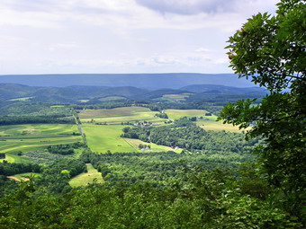 After the climb, the level part of the trail was welcome! At 1.55 miles the Red X-1 trail crossed our path. The Red X trails connect different parts of the Loyalsock Trail in different areas acting as shortcuts. There Rae eleven of them in all and can be interesting adventures in their own right. All, true to their name, are marked with red X's. We continued on and at 2 miles the Loyalsock Trail turned left. A woods road was to the right and straight ahead was a bridle path to allow horses access to the plateau. After this point the trail began to climb some but it was hardly noticeable when compared to the initial climb. We were now walking west to east along the Allegheny Front and I was looking for viewpoints. There were places that might be lookouts when there are fewer leaves on the trees but not on this day. Finally, at about 2.9 miles around 11:50 AM a limited viewpoint opened up and I took some shots. The trail was interesting in this area as it was ascending and we were walking very close to the edge of the Front. As we continue on another viewpoint, the best yet, opened up on a rock ledge with nice views to the south. I took a couple of pictures and then realized that an even nicer rock shelf with better views lay below. I took my camera and started down the short path. I immediately head a "Zing!" and saw two large, black rattlesnakes head into the brush from where they were sunning themselves on the rock! Once in the brush they continued to warm but didn't mover very far away. I kept a safe )?) distance and tried to get some pictures through the vegetation. I did get some shots good enough to show their girth, rattles and head. I took some more pictures from the viewpoint and then let Brad have a look at the rattlesnakes before we moved on.
 From "rattlesnake Rock" the trail began to descend gently for about .5 miles until it took a sharp left and headed down a rocky drainage. The hike down this part of the trail was tricky as the rocks were mossy and damp in places. I slipped several times on the way down but always caught myself. There were some very tall and very straight trees along this route. These trees may not have been first growth but they were old. Loggers in this area harvested white pine for ship masts and when the white pines were done they turned to hemlocks. The hemlock bark was used for tanning and, many times, the rest of the tree lay unused. Over the next 1.2 miles we dropped over 950 feet and the total drop from the highest point was over 1100 feet. The trail crosses Little Bear Road where we turned left and started to walk back out to Route 87. I though about hiking the Smith Knob loop but it was late in the day and we still had prep work to OD back at the house. We walked .8 miles out to Route 87, turned left and walked .5 miles to the car to complete the loop. We were back at 1:35 PM having covered the 6.2 mile loop in 3 hours and 22 minutes.
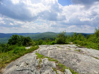
![]()
![]() On Friday, August 5th I finished the Breakneck Ridge hike by 1:00 PM and, despite the fact that I was tired, I was looking for another short hike. I drive Route 6, Long Mountain Parkway, frequently and have noticed a place where there are "hiker" signs. I consulted my maps and found that the Long Path crosses here and that a memorial to Raymond Torrey is located on Long Mountain close to the summit. Raymond Torrey was a founding member of the new York New Jersey Trail Conference and instrumental in the creation of the Long Path. Sheba and I pulled off at the Turkey Hill Parking area and started out on the Long Path at about 1:25 PM. There were at least a dozen cars parked and I knew that meant the trail would be crowded. We kept up[ a good pace as the first part of the trail descends and crosses the Popolopen Torne Trail. We stayed on the Long Path and start a short ascent up a hill. The trail flattened out at the top and, to my surprise, there were no other hikers present. The memorial is a message carved into the exposed bedrock at the top of the ridge. The views were good despite the haze. I could see the Perkins Tower on Bear Mountain. Turkey Hill Lake lay below. I took some pictures and then we started back. We met two hikers on the way down from the ridge and another hiker just after the trail junction. We were back at the car at 2:10 PM and had covered 1.2 miles in 45 minutes. I do not know where all the other people had gone but this hike definitely has a lot to offer for very little effort.
On Friday, August 5th I finished the Breakneck Ridge hike by 1:00 PM and, despite the fact that I was tired, I was looking for another short hike. I drive Route 6, Long Mountain Parkway, frequently and have noticed a place where there are "hiker" signs. I consulted my maps and found that the Long Path crosses here and that a memorial to Raymond Torrey is located on Long Mountain close to the summit. Raymond Torrey was a founding member of the new York New Jersey Trail Conference and instrumental in the creation of the Long Path. Sheba and I pulled off at the Turkey Hill Parking area and started out on the Long Path at about 1:25 PM. There were at least a dozen cars parked and I knew that meant the trail would be crowded. We kept up[ a good pace as the first part of the trail descends and crosses the Popolopen Torne Trail. We stayed on the Long Path and start a short ascent up a hill. The trail flattened out at the top and, to my surprise, there were no other hikers present. The memorial is a message carved into the exposed bedrock at the top of the ridge. The views were good despite the haze. I could see the Perkins Tower on Bear Mountain. Turkey Hill Lake lay below. I took some pictures and then we started back. We met two hikers on the way down from the ridge and another hiker just after the trail junction. We were back at the car at 2:10 PM and had covered 1.2 miles in 45 minutes. I do not know where all the other people had gone but this hike definitely has a lot to offer for very little effort.
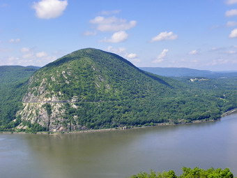
![]()
![]() On Friday, August 5th I returned to Breakneck Ridge to climb it with a number of people from a MeetUp group. We were supposed to start at 9:30 AM but didn't get started until about 9:50 PM as we waited for a few people. When we shoved off from the big parking area on Route 9D just north of the tunnel, there were 6 other hikers. Thee plan was to climb Breakneck Ridge and then return by the Bypass Trail. I had never cut the hike this short and contemplated adding some mileage but decided to stay with the group. This trail is VERY steep in spots with whole sections at more than a 50% grade. The group started off at a rather quick pace which slowed some after several of the climbs. Sheba and I took some of the easier routes around the steepest climbs. I stopped to take pictures frequently even though I have many pictures from this hike. We stopped for a break near the top and then pushed on. We hit the highest point at 1.4 miles around 11:50 AM.
On Friday, August 5th I returned to Breakneck Ridge to climb it with a number of people from a MeetUp group. We were supposed to start at 9:30 AM but didn't get started until about 9:50 PM as we waited for a few people. When we shoved off from the big parking area on Route 9D just north of the tunnel, there were 6 other hikers. Thee plan was to climb Breakneck Ridge and then return by the Bypass Trail. I had never cut the hike this short and contemplated adding some mileage but decided to stay with the group. This trail is VERY steep in spots with whole sections at more than a 50% grade. The group started off at a rather quick pace which slowed some after several of the climbs. Sheba and I took some of the easier routes around the steepest climbs. I stopped to take pictures frequently even though I have many pictures from this hike. We stopped for a break near the top and then pushed on. We hit the highest point at 1.4 miles around 11:50 AM.
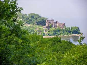 We walked over the highest point on the ridge and then turned left on the Bypass Trail. As we walked into a small clearing, the trail seemed to disappear. An informal trail led steeply down but was not marked. Eventually someone found the blazes of the Bypass Trail a little further up the ridge. The Bypass trail turns left off the Breakneck Ridge Trail and then makes another sharp left so that it parallels the Breakneck Ridge Trail for a short distance before heading more to the north. The trail descends 770 feet over the next .7 miles to a junction with the Wilkinson Trail. The descent is eroded with rocks and roots to further complicate getting a good foothold. We turned left on the Wilkinson Trail and headed toward Route 9D. In less than ,5 miles we were at the road. A short road walk brought us back to the parking area by 12:50 PM. We covered 3.2 miles in 3 hours. I was surprised at how tired I was!
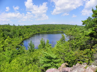
![]()
![]() On Tuesday, August 2nd I finished my ill-fated trip to Terrace Pond by 11:00 AM and was ready to continue my explorations. I had been stopped on my way to Terrace Pond by an expansion of a gas pipeline that cut the Terrace Pond North trail at about the halfway point. Not wanting to trespass pass on the right-of-way or endanger myself or Sheba, we turned around and headed back to the car. I had intended to visit Surprise Lake, Bearfort North and West Pond and didn't see any reason to change my plans. I headed east on the Warwick Turnpike and then turned north on Route 210. Just before the road crossed into New York I turn left onto the trail head access road which also serves a marina. Last time we had visited we hiked the route in a clockwise direction. For some variety I decided to hike this time in an anticlockwise direction. This would mean almost all the ascending would be at the beginning of the hike but that the return trip would be all downhill. We got on the blue State Line Trail to start the hike at about 11:15 AM. The beginning of this trail wanders around at low elevation before beginning the serious climb to the ridge. I was struck by how dry it was in the area. The dirt was dust and all of the small stream were dry! The trail is marked with blue on white squares which are difficult to follow at times. This is a very popular area and people have made their own sets of paths which can be misleading. The trail is mostly a wide woods road although at times it seems more like a creek bed! At around .7 miles we passed by the yellow Ernest Walter Trail but I elected to use this for the return trip. We continued to ascend to the top of the ridge where the State Line Trail ends at the Appalachian Trail. Near the top we went up and down over several small ridges before finally hitting the AT.
On Tuesday, August 2nd I finished my ill-fated trip to Terrace Pond by 11:00 AM and was ready to continue my explorations. I had been stopped on my way to Terrace Pond by an expansion of a gas pipeline that cut the Terrace Pond North trail at about the halfway point. Not wanting to trespass pass on the right-of-way or endanger myself or Sheba, we turned around and headed back to the car. I had intended to visit Surprise Lake, Bearfort North and West Pond and didn't see any reason to change my plans. I headed east on the Warwick Turnpike and then turned north on Route 210. Just before the road crossed into New York I turn left onto the trail head access road which also serves a marina. Last time we had visited we hiked the route in a clockwise direction. For some variety I decided to hike this time in an anticlockwise direction. This would mean almost all the ascending would be at the beginning of the hike but that the return trip would be all downhill. We got on the blue State Line Trail to start the hike at about 11:15 AM. The beginning of this trail wanders around at low elevation before beginning the serious climb to the ridge. I was struck by how dry it was in the area. The dirt was dust and all of the small stream were dry! The trail is marked with blue on white squares which are difficult to follow at times. This is a very popular area and people have made their own sets of paths which can be misleading. The trail is mostly a wide woods road although at times it seems more like a creek bed! At around .7 miles we passed by the yellow Ernest Walter Trail but I elected to use this for the return trip. We continued to ascend to the top of the ridge where the State Line Trail ends at the Appalachian Trail. Near the top we went up and down over several small ridges before finally hitting the AT.
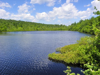 When we finally ascended the last little ridge to the AT it was 11:55 AM and we had hike about a mile. It seemed like some of the trail went straight up but the steepest sections were only about a 17% grade. We turned left onto the AT and began to walk along the ridges of rock typical of the Bearfort and Bellvale ridges. We were only on the AT for about .3 miles but we were lucky enough to meet a solo through hiker. He had started in Georgia and hoped to be at Katahdin by late September or early October. After a brief conversation, we parted ways. My spirits were lifted by this young man on a difficult quest. When the yellow Ernest Walter trail appeared on the left in a little swale we turn left and followed it. Walking this trail don't seem much different than the section of the AT we had left as it continued along the rock ridge. The ridge can be hard to walk and narrows in some places and there really isn't much of a view. After about .6 miles the trail started to go down and I thought this was a good place to begin the bushwhack to Bearfort North. I was wrong. We continued straight ahead but then I began drifting too far north. I couldn't visualize the high point as everything was thick laurel and other brush. I kept heading west until I found I was actually west of the high point and turned due east. Eventually I hit the highest point around and my GPS confirmed the location. I recognized the spot from the last time I was there but my path wasn't even close. It didn't help that there were many paths around and non seemed to go where I wanted. There was no view from the summit so I walked around a little. Some views may be possible but only during seasons with less vegetation. As I got ready to leave Sheba found a wide, unmarked trail that was easy to follow and headed the way I wanted to go. Eventually the trail started to go too far north so I headed east and ended up in the same place I had left the Walter Trail. After looking at my GPS track on the computer, I saw that I should have stayed on the main trail for about 300 more feet until it turned 90 degrees. At that point another 300 feet due west would have put me right on the unmarked path that Sheba found. Somehow it seemed easier to realize this when I hike it from the opposite direction.
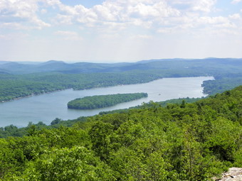 On the main trail things went much more smoothly. In a short distance we made a sharp but short descent into the outlet of West Pond and then a similar sharp but short ascent on the other side. Within .25 miles we were walking out the short spur trail to the viewpoint over West Pond. This viewpoint is beautiful and always deserted. It was a little after 1:30 PM so we had a drink and Sheba and I split a peanut butter on pita. I took quite a few pictures and then we headed out to Surprise Lake. We climbed a short distance to the top of the ridge and met a group of six young people enjoying the sun. After that, it was a descent to the trail that leads across the outlet to Surprise Lake. The drop is about 100 feet but it is not steep. Soon we were on the trail that parallels the lake. This trail is interesting as most of it passes through a laurel tunnel. There is an interesting split rock along the way and a short rocky ascent to the "beach" on the lake. This area has no sand but people do seem to like to swim there. Some of the teenagers decided to take a dip while I moved to two other viewpoints to take unobstructed pictures. This lake is also secluded but gets quite a few visitors. After taking my shots, we started the short walk back on the main trail. The trail breaks out onto the ridge and ascends slightly to give some great views of Greenwood lake and the mountains beyond. The mountains were still hazy but the views of the lake were good, I took pictures and then we started down to the State Line Trail. The trail junction is less than half a mile from the lake and we were soon descending the State Lien Trail. The descent should have been easy but the dry dirt and round rocks coupled with the steepness of the trail in spots warranted caution. We were back at the car at 3:00 PM having covered the 5.1 mile hike in 3 hours and 40 minutes. This is lower than our usual pace but included plenty of time for pictures and an off trail adventure.
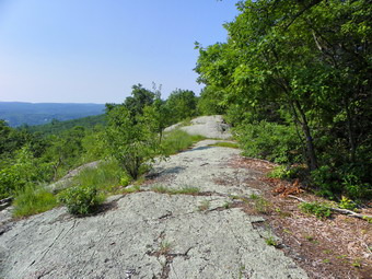
![]()
![]() On Tuesday, August 2nd I decided to return to New Jersey. I had meant to go to hike some of the trails this winter but somehow time slipped by. Last summer I did a lot of hiking "below the border" as I was finishing the NJ1K list. This summer I had not yet been in New Jersey so I headed for Greenwood Lake. My intention was to hike to Terrace Pond. The last time we were there we had some fantastic views but Cindy did not want to hike around the pond. I wanted to do that loop and hit the Bearfort Mountain high point again. I arrived at the parking pull off just west of White Road at 9:40 AM. Sheba and I braved the traffic to cross the road and start the hike. As soon as we climbed the bank, I saw a "Trail Closed" sign. I was disappointed but there was indication of why the trail was closed and I have always taken these signs as more of "Hike at your own risk". I decided to continue and we followed the blue trail across the private property and onto state land. The trail blazes were new and much easier to follow than last time. From the road the trail rises to a ridge for the next .7 miles. Along the way I kept hearing the noise of machinery and assumed it was over the ridge. Even the more remote parts of New Jersey aren't far from a road or inhabited area. Once on the ridge there are some limited views over Greenwood Lake but what I was really looking forward to were the views from the right-of-way. Last time Cindy and had visited we had some of the most magnificent views over the lake and across the countryside. The right-of-way was steep since we had to make a right turn and head up to the very top of the ridge before picking up the trail to the pond. Still, the ascent was short and well worth the effort.
On Tuesday, August 2nd I decided to return to New Jersey. I had meant to go to hike some of the trails this winter but somehow time slipped by. Last summer I did a lot of hiking "below the border" as I was finishing the NJ1K list. This summer I had not yet been in New Jersey so I headed for Greenwood Lake. My intention was to hike to Terrace Pond. The last time we were there we had some fantastic views but Cindy did not want to hike around the pond. I wanted to do that loop and hit the Bearfort Mountain high point again. I arrived at the parking pull off just west of White Road at 9:40 AM. Sheba and I braved the traffic to cross the road and start the hike. As soon as we climbed the bank, I saw a "Trail Closed" sign. I was disappointed but there was indication of why the trail was closed and I have always taken these signs as more of "Hike at your own risk". I decided to continue and we followed the blue trail across the private property and onto state land. The trail blazes were new and much easier to follow than last time. From the road the trail rises to a ridge for the next .7 miles. Along the way I kept hearing the noise of machinery and assumed it was over the ridge. Even the more remote parts of New Jersey aren't far from a road or inhabited area. Once on the ridge there are some limited views over Greenwood Lake but what I was really looking forward to were the views from the right-of-way. Last time Cindy and had visited we had some of the most magnificent views over the lake and across the countryside. The right-of-way was steep since we had to make a right turn and head up to the very top of the ridge before picking up the trail to the pond. Still, the ascent was short and well worth the effort.
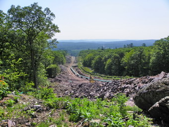 Less than a mile into the hike we descended off the ridge and the trail blazes disappeared in a swampy area. We continued to follow what looked like the trail and soon I could see the right-of-way ahead. I was NOT prepared for what I saw next. There was a low fence and signs announcing a construction area. I hopped the fence and found the entire right-of-way was dug up and a new pipeline was being installed. The grassy area had been widened and now was just bare dirt and rock. As I looked up the slope I could see construction machinery at work further destroying the beautiful landscape. I was shocked and dismayed. I did not see how I could safely traverse this area and a look at my maps showed no other trail from my location. I took some pictures of the devastation and decided to return to the car. When I returned home in the afternoon, I went to the New York New Jersey Trail Conference site and found an explanation for the construction. This is an "upgrade" to the Tennessee Gas Pipeline Company existing pipeline. It cuts the Terrace Pond Trail in half. What is even more disturbing is that the company has applied for permits to build more pipeline including some UNDER the Monkville Reservoir. The construction would bisect trails in 20 different places including interruptions of the Highlands Trail and Appalachian Trail. Public hearings are being held and I hope the company will be prevented from destroying this beautiful area. We were back at the car by 11:00 AM. The 2.2 mile round trip too us less than 1.5 hours bu7t made a lasting negative impression of this company's plans!
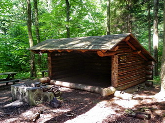
![]()
![]() On Monday, August 1st Cindy and I wanted to take a short hike somewhere after a taxing Sunday with the grandchildren. I had always wanted to go to Kelly Hollow but had bypassed it for "better" hikes. At first, I thought I might have to go alone and thought about bushwhacking up to the Millbrook Ridge. Fortunately Cindy decided to come along and I will save the bushwhack for another day. As we drove along the Pepacton Reservoir it looked like the day was going to be perfect with some sun and moderate temperature and humidity. Along the Millbrook Arena Road we noticed several signs on the property of the Tuscarora Club. Each small, white sign read something like "Demis End" or "Club House End". These signs had obviously been there for some time but it was the first time we had seen them and we had no idea what they meant. We arrived at the parking area at about 10:30 AM and started hiking almost immediately. The Kelly Hollow trail is a loop and is marked for cross country skiing. The trail makes a nice but short hiking loop and would be good for snowshoeing as well. As soon as we entered the woods, we had to make a decision. It appeared that the trail split but only the left branch was marked so we headed that way. For 1.25 miles the trail slowly rises toward the foot of Millbrook Ridge. It is a wide woods road in most places and parallels a branch of an unnamed stream. The stream had very little water but the bed it had carved was deep indicating that the volume increases seasonally. Over the next .75 miles the trail generally heads west with a northerly "bow" to skirt the base of the ridge. The trail travels over some humps and bumps but the elevation does not change too much.
On Monday, August 1st Cindy and I wanted to take a short hike somewhere after a taxing Sunday with the grandchildren. I had always wanted to go to Kelly Hollow but had bypassed it for "better" hikes. At first, I thought I might have to go alone and thought about bushwhacking up to the Millbrook Ridge. Fortunately Cindy decided to come along and I will save the bushwhack for another day. As we drove along the Pepacton Reservoir it looked like the day was going to be perfect with some sun and moderate temperature and humidity. Along the Millbrook Arena Road we noticed several signs on the property of the Tuscarora Club. Each small, white sign read something like "Demis End" or "Club House End". These signs had obviously been there for some time but it was the first time we had seen them and we had no idea what they meant. We arrived at the parking area at about 10:30 AM and started hiking almost immediately. The Kelly Hollow trail is a loop and is marked for cross country skiing. The trail makes a nice but short hiking loop and would be good for snowshoeing as well. As soon as we entered the woods, we had to make a decision. It appeared that the trail split but only the left branch was marked so we headed that way. For 1.25 miles the trail slowly rises toward the foot of Millbrook Ridge. It is a wide woods road in most places and parallels a branch of an unnamed stream. The stream had very little water but the bed it had carved was deep indicating that the volume increases seasonally. Over the next .75 miles the trail generally heads west with a northerly "bow" to skirt the base of the ridge. The trail travels over some humps and bumps but the elevation does not change too much.
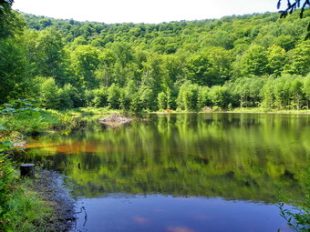 We arrived at the end of the traverse at about 11:30 AM. There is a beaver pond at this point. The beavers have sealed the outlet of the pond but there seems to be an old stone dam there as well. There is a lean-to complete with a privy in this area. The lean-to is in good shape and the privy is new since it was built as an Eagle Scout project. We stopped and dropped our packs to inspect the lean-to and the beaver pond. After a drink and a little lunch, we continued to follow the trail as it looped around the back of the beaver pond. The trail here was narrow and not well cleared. I thought there was no beaver activity in the pond but around the other side we found some newly fallen trees. The trail turns generally north here to head back to the road and again parallels a branch of the stream. About .7 miles from the lean-to I noticed what looked like a waterfall in the stream bed. We were high above the stream but I walked and slid my way down into the creek just downstream of the falls. There was little water going over the falls on this day but its appearance made me believe that it might be quite interesting after some heavy rains. I worked my way back up to the trail passing a lone cement block on the hill. Back on the trail we hiked about .7 miles until we were near the road.
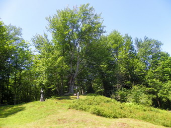 At this point a cemetery appeared on the left side of the trail. Some DEC workers told us this was the Dry Brook Cemetery. Cindy and I were both surprised at how well kept it was. We walked around respectfully examining the inscriptions on the stones. The latest burial was 2001 but many stones were from the early part of the 20th century with many more being even earlier. Some of the headstones were placed in "raised beds" which I had never seen before. The oldest graves were on a hill under a very old tree. Quite a few were burials from the Civil War and some were marked by only a piece of local stone without an inscription. After walking around for about 15 minutes we walked out to the road and turned left to hike the final .25 miles back to the car. Without the cemetery side trip, the hike was 3.7 miles which we covered in under 2 hours. On the way we saw the same white signs as we had seen on the way in. This time the signs said something like "Demis Start" or "Club House Start". The Tuscarora Club apparently has trails from the Road down to Mill Brook for its members. When we got home, I looked up some of the names from the graves and found a lot of historical information. One site listed all the marked graves and the inscriptions. Another site indicated that the Civil War graves were the resting place of members of Company G of the 144th New York Infantry. The 144th was from Delaware County and Company G was from The Town of Middletown. The company was attached to several different armies and spent time in South Carolina and Florida. They were at the liberation of Fort Wagner and Fort Sumter.
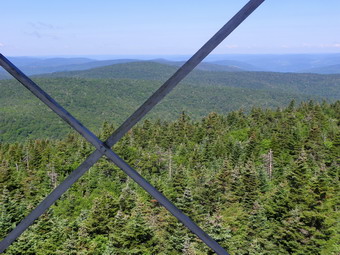
![]()
![]() On Saturday, July 30th I made arrangements with Jane to come to my house at about 8:00 AM so that we could drive to the Beaverkill trail head to hike Balsam Lake and Graham. We had talked about including Graham to Doubletop but I had an afternoon family commitment. I DO want to try this bushwhack some time but probably do it as a through hike with a car spot. Jane arrived and we were soon on our way to the end of the Beaverkill Road. I enjoy taking people on hikes when I can talk about the history of the area and show others points of interest. We arrived at the trail head just before 9:00 AM to find only one other car. The temperature was in the low 70's with a slight breeze. We started up the trail and I signed in at the register. The other hikers were listed as going to Balsam Lake and then taking the trail to Alder Lake and Big Pond. We hit the first trail junction at around 9:20 AM and turned left to start up the mountain. The ascent seemed a little more difficult than in the past but the trail was in good shape and there was a slight breeze. We walked passed the side trail to the lean-to and were soon at the spring. Sheba got a drink before we made the last push to the top of the climb arriving at around 10:00 AM. The steepest part of this ascent is only .6 miles and gains 765 feet but this is about a 25% grade which is a good workout. From the top off the climb to the fire tower almost seems flat and it took us a little more than 10 minutes. WE dropped our packs and were ready to climb the tower by 10:15 AM. I went to the landing just below the cab and started to take some pictures. There was a strong breeze blowing. After a few shots, my camera stopped working so I went back Down the tower to try new batteries. Meanwhile, Jane was going up to enjoy the view. I thought I had checked and replaced the batteries in the camera recently but changing them did the trick and I headed back up the tower. The views were a little hazy but the light was good so I took some pictures. I must have taken these same pictures dozens of times before but I still like the view. The ruins on Graham were clearly visible and it reminded us of our next objective.
On Saturday, July 30th I made arrangements with Jane to come to my house at about 8:00 AM so that we could drive to the Beaverkill trail head to hike Balsam Lake and Graham. We had talked about including Graham to Doubletop but I had an afternoon family commitment. I DO want to try this bushwhack some time but probably do it as a through hike with a car spot. Jane arrived and we were soon on our way to the end of the Beaverkill Road. I enjoy taking people on hikes when I can talk about the history of the area and show others points of interest. We arrived at the trail head just before 9:00 AM to find only one other car. The temperature was in the low 70's with a slight breeze. We started up the trail and I signed in at the register. The other hikers were listed as going to Balsam Lake and then taking the trail to Alder Lake and Big Pond. We hit the first trail junction at around 9:20 AM and turned left to start up the mountain. The ascent seemed a little more difficult than in the past but the trail was in good shape and there was a slight breeze. We walked passed the side trail to the lean-to and were soon at the spring. Sheba got a drink before we made the last push to the top of the climb arriving at around 10:00 AM. The steepest part of this ascent is only .6 miles and gains 765 feet but this is about a 25% grade which is a good workout. From the top off the climb to the fire tower almost seems flat and it took us a little more than 10 minutes. WE dropped our packs and were ready to climb the tower by 10:15 AM. I went to the landing just below the cab and started to take some pictures. There was a strong breeze blowing. After a few shots, my camera stopped working so I went back Down the tower to try new batteries. Meanwhile, Jane was going up to enjoy the view. I thought I had checked and replaced the batteries in the camera recently but changing them did the trick and I headed back up the tower. The views were a little hazy but the light was good so I took some pictures. I must have taken these same pictures dozens of times before but I still like the view. The ruins on Graham were clearly visible and it reminded us of our next objective.
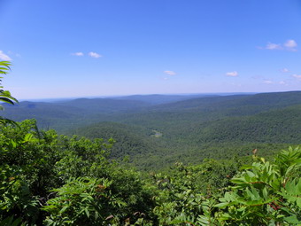 We shouldered our packs and headed down the other side of the mountain. There were few insects and the air temperature was still very pleasant with a breeze. There were very few insects to bother us and we made good time. Along the way we met one hiker coming up from the Millbrook trailhead. Soon we were at the second trail junction where we turned left and started to look for the Graham herd path. Each time I hike this route the herd path becomes more and more obvious although it seems this is from use since no one appears to be "maintaining" it. We had started down at about 10:30 AM and made the turn to Graham around 11:00 AM. The herd path had a few prickers and nettles in places but these hardly required a whack on the way by. There were one or two new blowdowns across the path. This path always fools me as it seems longer than I remember every time. I am always disturbed by the fact that it descends some before the climb. After walking for 1.3 miles down or flat, the next .8 miles up Graham seemed steep. In fact, the climb is under 15% with a few very short steeper sections. When we finally passed the lookout on the left, I knew we were close to the top and we made a final push to the ruins arriving just after noon. We dropped our packs and decided we would walk out to a viewpoint. There wasn't too much top see because of the leaves on the trees but we started to walk around the summit anticlockwise. This was easier in some places than others with a few pretty dense spots. We did find one or two viewpoints before heading back to the tower. After a drink and some lunch, we started back down at around 12:45 PM. The descent went quickly and we were soon at the turn back onto the main trail. From here we headed straight back to the second and then the first trail junctions. Although Jane and I usually talk up a storm while we hike, we were both quiet on the way back, lost in our on thoughts and the beauty of the hike. As we passed the register, two hikers that I knew from Livingston Manor were signing in. We talked for a minute and then walked back to the car. We were in the parking area by 2:45 PM. The 8.5 mile hike took just under 6 hours but we had taken quite a bit of time for pictures and our off trail excursion on Graham.
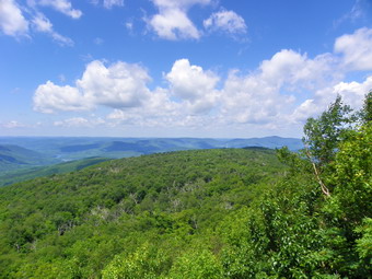
![]()
![]() On Tuesday, July 26th Cindy and I wanted to take advantage of the cooler temperatures to finally get in a hike! High temperatures and high humidity had kept me sidelined from hiking for too long! I substituted some bike rides but it just wasn't the same. We decided, after some discussion, to hike to the Penguin Rocks lookout on Dry Brook Ridge from the German Hollow trailhead in Arkville. The forecast suggested that there might be showers after noon so our relatively late start did not thrill me. We parked at the end of Chris Long Road off the Dry Brook Road at about 9:45 AM and started hiking immediately. This passed winter I had hiked this route and it was very difficult. During that hike I had made the mistake of leaving my snowshoes in the car since there was only a dusting of snow down low. The higher I got the more snow there was and the going was miserable. I thought that for this hike we would probably be OK up to the lean-to and a little father. I suspected at some point we would run into some nettles in the more open and wetter areas and then lose them again near the top of the trail. About 10:05 AM we arrived at the lean-to after hiking .7 miles. We took a look from the trail and continued up toward the ridge. The German Hollow Trail is not steep but is a constant climb to the ridge. We did run into some heavy patches of nettles which I "whacked". Once the trail started to level near the top it nearly disappeared in several places. It is obvious that the trail gets little use and is not well-maintained. By 10:55 AM we had arrived at the trail junction after hiking 1.7 miles and gaining 1260 feet.
On Tuesday, July 26th Cindy and I wanted to take advantage of the cooler temperatures to finally get in a hike! High temperatures and high humidity had kept me sidelined from hiking for too long! I substituted some bike rides but it just wasn't the same. We decided, after some discussion, to hike to the Penguin Rocks lookout on Dry Brook Ridge from the German Hollow trailhead in Arkville. The forecast suggested that there might be showers after noon so our relatively late start did not thrill me. We parked at the end of Chris Long Road off the Dry Brook Road at about 9:45 AM and started hiking immediately. This passed winter I had hiked this route and it was very difficult. During that hike I had made the mistake of leaving my snowshoes in the car since there was only a dusting of snow down low. The higher I got the more snow there was and the going was miserable. I thought that for this hike we would probably be OK up to the lean-to and a little father. I suspected at some point we would run into some nettles in the more open and wetter areas and then lose them again near the top of the trail. About 10:05 AM we arrived at the lean-to after hiking .7 miles. We took a look from the trail and continued up toward the ridge. The German Hollow Trail is not steep but is a constant climb to the ridge. We did run into some heavy patches of nettles which I "whacked". Once the trail started to level near the top it nearly disappeared in several places. It is obvious that the trail gets little use and is not well-maintained. By 10:55 AM we had arrived at the trail junction after hiking 1.7 miles and gaining 1260 feet.
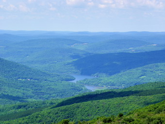 We turned left on the Dry Brook Ridge Trail which is in better shape than the one up from German Hollow. This trail up to the ridge from Margaretville gets some more use but not as much as the route up from Hill Road. The trail continues to climb for the next half mile but along the way almost disappears again in a sea of ferns. After this the trail descends over 100 feet before a nasty little steep ascent to the junction with the Huckleberry Loop Trail from Hill Road. The ascent is not over at this point so we stopped for a drink and a snack. At this point swarms of flies found us so we decided to cut the break short and continue on. The temperature was cooler on the ridge and there was a breeze blowing despite the fact that we were surrounded by the forest. The trail up to the lookouts winds its way along the ridge and changes direction several times. The hiking is fairly easy since this part of the trail is well used. There are a few short climbs to gain the additional 200 feet to the elevation of the lookouts. We arrived at the Penguin Rocks just before 12:30 PM having hiked about 3.6 miles. The sun was out and a breeze was blowing. There were no flies to speak of so we dropped our packs and took a break. Whenever I have visited this lookout there has been a haze in the valley below. On this day the views were as clear as I have ever seen with a beautiful blue sky hanging over the green landscape. The puffy white clouds added another dimension to the scene as I took some shots before dropping to the lower ledge. This ledge slopes away and I was careful as I edges out to take some ore pictures including several of the drop-off!
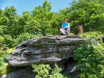 We stayed at the lookouts for about 10 minutes and started back. It had taken us about 2 hours and 45 minutes to hike up and I asked Cindy how quickly she though we could make it back. She told me here knees were hurting so the trip back might be slow. We set out at a quick pace along the ridge and were back at the Huckleberry Loop Trail junction by 1:05 PM. The going was a little slower as we made the descent down the steeper trail section and then climbed back up. After that we were back on pace and arrived at our turn onto German Hollow at 1:35 PM. The trip down the German Hollow Trail went MUCH quicker than trip up. This was partly due to the fact that it is down but also had to do with the fact that I had already whacked most of the nettles and prickers out of the way. In addition, as we were descending the skies appeared to grow darker and we could hear thunder rumbling in the distance! I had intended to stop at the lean-to but we passed it by and headed for the car. We were back by 2:25 PM which meant we had returned in 1 hour and 50 minutes cutting almost an hour off our ascent! We covered the 7.1 mile hike in 4 hours and 42 minutes. As we drove out to Route 28 the skies all around were dark. As we made the turn toward Roscoe on Route 206 the rain came in earnest and continued until we were back in Livingston Manor.
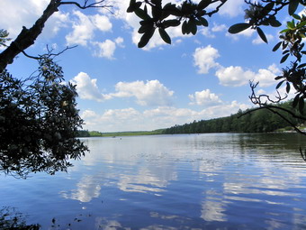
![]()
![]() On Saturday, July 16th I wanted to take a short hike in Bethel. Brad also wanted to go so we parked at the farm and walked the roads to a woods road called the Ricky Run Road near Indian Field. The Rocky Run Road is part of the old Newburgh-Cochecton Turnpike and we hiked it extensively when I was growing up on Dr. Duggan Road. The woods road was very prominent and showed traces of tracks. I remembered many of the twists and turns and the ridges that line the road in places. It was a hot day with temperatures in the high 80's and high humidity. The road, however, was almost dry. After about 1.5 miles, we noticed that we were both being attacked by a HUGE swarm of mosquitoes. I broke out the DEET but we both had many bites before we got the repellent sprayed on our exposed areas. We continued to walk but the mosquitoes didn't seemed phased by the DEET so we made the decision to turn back. I was feeling a little delicate but I didn't feel it was worth getting eaten alive for a simple walk. As we returned on Indian Field Road another woods road went off to the left on state land. I started to follow this road waiting to see if the mosquitoes would return. Happily there were few insects and the road led to the path above Ernie's Pond that leads up to Lake Superior. We followed the path passing by some laurel in full bloom. We were soon at a spot directly across from the bathing area on the other side. I walked down to the shore to take some pictures of the lake and the bathing area.
On Saturday, July 16th I wanted to take a short hike in Bethel. Brad also wanted to go so we parked at the farm and walked the roads to a woods road called the Ricky Run Road near Indian Field. The Rocky Run Road is part of the old Newburgh-Cochecton Turnpike and we hiked it extensively when I was growing up on Dr. Duggan Road. The woods road was very prominent and showed traces of tracks. I remembered many of the twists and turns and the ridges that line the road in places. It was a hot day with temperatures in the high 80's and high humidity. The road, however, was almost dry. After about 1.5 miles, we noticed that we were both being attacked by a HUGE swarm of mosquitoes. I broke out the DEET but we both had many bites before we got the repellent sprayed on our exposed areas. We continued to walk but the mosquitoes didn't seemed phased by the DEET so we made the decision to turn back. I was feeling a little delicate but I didn't feel it was worth getting eaten alive for a simple walk. As we returned on Indian Field Road another woods road went off to the left on state land. I started to follow this road waiting to see if the mosquitoes would return. Happily there were few insects and the road led to the path above Ernie's Pond that leads up to Lake Superior. We followed the path passing by some laurel in full bloom. We were soon at a spot directly across from the bathing area on the other side. I walked down to the shore to take some pictures of the lake and the bathing area.
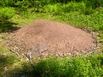 We turned around to head back down to the pond. The paths are pretty well-defined at this point and easy to follow. This all brought back a lot of memories since my friends and I crossed and recrossed this area so many years ago. Along the path we ran across the large ant hills that I remembered. There were over two dozen of them with the largest being 5 feet in diameter and more than a foot high! As we approached the pond, we chose to take the "low road" and hike near the shore to the outlet of the pond. There is also a path higher up that walks along the ridge above the pond. We stopped to take pictures of the pond and the dam at the outlet end. We walked out to the road and then back on the road to the house where we had parked the car. Our 4 mile hike took a little under 2 hours.

![]()
![]() On Thursday, July 14th I decided to return to Sam's Point and hike the escarpment loop which I had not done in some time. Sheba and I arrived at the Conservation Center at 10:00 AM and started the hike almost immediately. There were a few other cars in the lot and I suspected some were berry picking. My intention was to hike just the "main" loop without visiting the ice caves or Indian Rock. I was surprised that the temperature was so comfortable hovering in the mid 60's. On the way up to Sam's Point I took some pictures of the cliffs and then stopped at the lower viewpoint. There was little haze and at that point I knew this would be a slow hike with a lot of time for pictures. The green of the vegetation and the blue of the sky was complemented by a lot of interesting, puffy, white clouds. We took the short spur to the Point and found no one there. Even though I have taken these pictures many times, I took them again and tried to get a new perspective. I captured some shots of the viewpoint and then some along the escarpment cliffs as well as some of the distant scenery. Back on the main trail we headed toward the turn off to the ice caves on the loop road. After turning right, we walked down the side road a short distance before turning left onto the trail down to Verkeerderkill Falls. This trail is rocky and often quite wet but on this day it was dry the entire length. In many places the trail was narrowed by the encroaching blueberry bushes and little had been done to maintain the trail. Along the first part there was a sea of low blueberry bushes with an occasional dwarf pine. I took some photographs and included some of the clouds for good measure. At one point the trail passes through a stand of hardwood trees and the first floor was covered in ferns. This required some more pictures! Most of the rest of the trail to the falls is rocky and passes through dwarf pines. The trail is always longer than I remember but we finally got to the falls at 11:45 AM after 3 miles of hiking 1.8 miles of which were on the trail.
On Thursday, July 14th I decided to return to Sam's Point and hike the escarpment loop which I had not done in some time. Sheba and I arrived at the Conservation Center at 10:00 AM and started the hike almost immediately. There were a few other cars in the lot and I suspected some were berry picking. My intention was to hike just the "main" loop without visiting the ice caves or Indian Rock. I was surprised that the temperature was so comfortable hovering in the mid 60's. On the way up to Sam's Point I took some pictures of the cliffs and then stopped at the lower viewpoint. There was little haze and at that point I knew this would be a slow hike with a lot of time for pictures. The green of the vegetation and the blue of the sky was complemented by a lot of interesting, puffy, white clouds. We took the short spur to the Point and found no one there. Even though I have taken these pictures many times, I took them again and tried to get a new perspective. I captured some shots of the viewpoint and then some along the escarpment cliffs as well as some of the distant scenery. Back on the main trail we headed toward the turn off to the ice caves on the loop road. After turning right, we walked down the side road a short distance before turning left onto the trail down to Verkeerderkill Falls. This trail is rocky and often quite wet but on this day it was dry the entire length. In many places the trail was narrowed by the encroaching blueberry bushes and little had been done to maintain the trail. Along the first part there was a sea of low blueberry bushes with an occasional dwarf pine. I took some photographs and included some of the clouds for good measure. At one point the trail passes through a stand of hardwood trees and the first floor was covered in ferns. This required some more pictures! Most of the rest of the trail to the falls is rocky and passes through dwarf pines. The trail is always longer than I remember but we finally got to the falls at 11:45 AM after 3 miles of hiking 1.8 miles of which were on the trail.
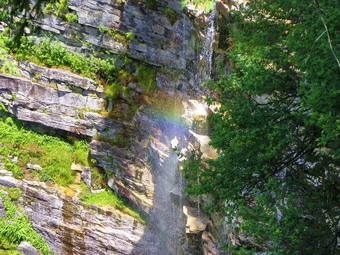 We stopped on the near side of the falls and walked out to the viewpoint. There was almost NO WATER going over the falls. I have seen it this dry only once before and was a little surprised since there had been so much rain. I took some pictures and noticed three people on the other side. Crossing the stream was no problem and we were soon on the other side. The far side of the stream offers more unobstructed views of the falls and the pool below. I took pictures of the falls and actual saw a small rainbow which photographed nicely. After some of the scenery and some conversation with the people from Middletown, Sheba and I headed out on the trail to climb back up to the escarpment. The trail climbs steeply but for only a short distance. We stopped at the first viewpoint so that I could take some pictures, a theme that would recur frequently on the way to High Point. As we left the viewpoint, a solo hiker passed by. At the trail junction with the path to Awosting, we turned left to continue along the escarpment. From the falls to High Point is about 2.56 miles. The trail passes along the edge of the cliffs with many wonderful views of the countryside. Sometimes the path dives into the dwarf pines only to emerge to more great views. I noticed the transmission towers opposite us across the gorge and knew we had some distance to go before we would pass by them on the way back. The route we were following heads northwest before making a 90 degree turn just passed High Point and heading southwest back-to-back the Conservation Center. Sheba and I walked up and over and down the various rock formations. I was surprised that she seemed able to handle most of the short, steep climbs with ease. In several places we stopped and Sheba went up on the higher rocks ahead of us to pose. Where the trail moves from the rocks into the scrub it is almost totally obscured by the blueberry bushes. No maintenance has been done untold about .3 miles from High Point. I hope the Center intends to finish cutting out the trails as the $10 use fee should include trails that are open and ease to find!
 By 1:25 PM we had hiked 5.5 miles and were standing on High Point. Sheba scrambled up behind me and we took in the view. The Smiley Tower at Mohonk and the cliffs of Hamilton and Castle Point were clearly visible. To the north were the outlines of the Catskill high peaks. After some time for pictures and a snack we started in again as I knew we still had more than 3 miles to go. In a few minutes we were at the trail that leads down to the carriageway. We walked passed this turn off to the area where the fire tower once stood. This lookout gives an even better view to the north and more pictures were in order. We walked back to the trail down to the carriageway and soon were headed back to the parking lot. There were a few muddy spots along the way but nothing compared to the continuous bogs that are often present. The sign at the top of the trail before descending says 2.4 miles to the center. The sign at the bottom gives 2.8 miles for the same distance. I have often wondered why someone didn't proofread this more carefully! The walk back always seems long but went quickly this time. The constant pounding on my legs and feet was beginning to take its toll as we approached the Center. We were back at the car by 2:40 PM having hiked 8.8 miles in 4 hours and 40 minutes. I counted this as a good pace given the amount of time we had stopped so that I could photograph.

![]()
![]() On Monday, July 11th I had an opportunity to hike to the Greater Ice caves at Sam's Point with my friend Phil, a running coach at Ellenville High School. Although these "caves" are part of the Sam's Point Preserve they are "primitive with no marked trail. Phil has been there many times and I appreciated his offer to be my guide. We met at the Berme Road Park behind the fire station in Ellenville about 10:30 AM and started our hike almost immediately. It was already 80 degrees with high humidity. Just out of the parking lot the path lead up through some rock formations with a short rock scramble. I took some pictures and we continued. The path lead to some roads and then we turned left up a steep bank and were on a path the rest of the way. In places the path was barely discernible and there was some blowdown along the way. We walked and talked as we hacked our way along the path. A few times we stopped for a short break, usually, at my request. I had Sheba and Phil had his chocolate Lab, Nibbles. Both dogs were eager to drink each time we stopped. After 1.7 miles and 1300 feet of climbing, we arrived at the first "cave" around 11:45 AM. The cool air coming from the cave was refreshing. We walked down into this crevasse in the Earth and the cool air became cold. We spent a few minutes there as I took pictures of the bottom of the cave and some interesting shot up at the sky above. There was no ice at the bottom but it was still a lot of fun. We headed for the next cave. Along the way Phil kept mentioning the "big" cave we would eventually visit.
On Monday, July 11th I had an opportunity to hike to the Greater Ice caves at Sam's Point with my friend Phil, a running coach at Ellenville High School. Although these "caves" are part of the Sam's Point Preserve they are "primitive with no marked trail. Phil has been there many times and I appreciated his offer to be my guide. We met at the Berme Road Park behind the fire station in Ellenville about 10:30 AM and started our hike almost immediately. It was already 80 degrees with high humidity. Just out of the parking lot the path lead up through some rock formations with a short rock scramble. I took some pictures and we continued. The path lead to some roads and then we turned left up a steep bank and were on a path the rest of the way. In places the path was barely discernible and there was some blowdown along the way. We walked and talked as we hacked our way along the path. A few times we stopped for a short break, usually, at my request. I had Sheba and Phil had his chocolate Lab, Nibbles. Both dogs were eager to drink each time we stopped. After 1.7 miles and 1300 feet of climbing, we arrived at the first "cave" around 11:45 AM. The cool air coming from the cave was refreshing. We walked down into this crevasse in the Earth and the cool air became cold. We spent a few minutes there as I took pictures of the bottom of the cave and some interesting shot up at the sky above. There was no ice at the bottom but it was still a lot of fun. We headed for the next cave. Along the way Phil kept mentioning the "big" cave we would eventually visit.
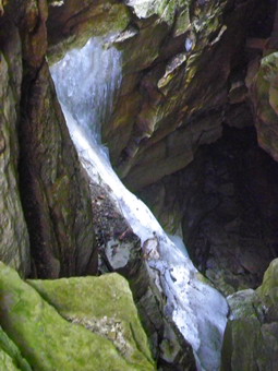 The next cave was a little harder to get down into and we could not safely get close to the bottom. We walk down into the crack and there was ICE AT THE BOTTOM. This was not a small sliver of ice but a substantial slab in July! I took pictures and then we walked out the other end of the crack. Our next stop was the BIG crevasse and Phil was telling the truth! It was by far the largest in all dimensions. As we walked along, I took pictures in several spots to try to capture the length, breadth and depth of this crack. About halfway along were several rock outcroppings that jutted out from the rocks and over the crack. I took some unobstructed pictures from these. I took Phil up on his offer top tale a CPR of Sheba and I on one of these viewpoints. Phil headed some distance away and took several shots. When he showed me the pictures, I saw that Sheba and I were standing on a shelf of rock about two feet thick hanging some 100 feet above the bottom below. I thanked Phil for the experience and the pictures! We walked a little further but did not find anything more of interest so we started back at about 12:45 PM after 2.4 miles of walking and exploration.
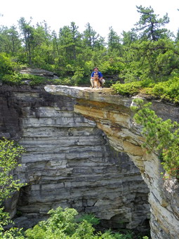 On the way back, we took a slightly different route. When we hit a woods road near a bungalow colony at about 4 miles we turned right and headed out to Route 52. We arrived at an interesting falls along a small creek. The falls can be seen from Route 52 just as it leaves Ellenville and starts up toward Cragsmoor. We worked our way down the bank to the creek. The two dogs and Phil decided to get wet. I decided to take pictures of the falls. Some people were present at then falls as I worked my way upstream. The falls are actually "recessed" behind a retaining wall as they have eroded into the mountain. I did not want to get wet so stop short of crossing the stream and took my pictures. I was done about the same time as the water-lovers so we leashed the dogs and headed out to Route 52 and walked back to the car. There was one last stop to make. We got in our cars and drove down Berme Road to J&M Originals, a child's clothing outlet. The business is housed in the SunRay Soda Bottling plant. The soda bottling went out of business some time ago but the building still stands. What is also present on the property is a tunnel that starts at the bottom of the ridge and runs hundreds of feet up into the rock. The water was sued in the soda bottling business and is filtered through the rock. The exact history of the tunnel is the object of some speculation.
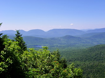
![]()
![]() On Saturday, July 9th I made arrangements with Jane and Jon to hike the Blackhead Range. The weather report was for warm temperatures with partly cloudy skies. I looked at the various routes including Colgate Lake to Barnum Road and Barnum Road to Peck Road including Windham in the hike. I really want to do both of these routes and the fact that we would have three cars made both inviting prospects. Both of these routes are 13 miles and more and I finally decided this was a little beyond what I wanted to do for the day. An ambulance call that took away 3 hours of sleep during the night cemented my decision. I decided we would all park at the Batavia Kill area and hike the Batavia Kill trail to the Escarpment trail and go up the steeper north approach to Blackhead. This approach has several rock scrambles and would allow us to walk across to Black Dome and Thomas Cole and return by way of the Black Dome trail to the parking area. We met in Hunter and drove to Maplecrest and out Big Hollow Road to the parking area. There were a few cars in the parking area with one inconsiderate driver taking up what could have been several spaces. We were on the trail by 9:15 AM. Jon is new to hiking but is very fit and a string hiker. Today's hike would be at my pace however. The Black Dome Trail from the parking area is very rocky and ALL the rocks were damp and slippery. We made our way along the trail carefully until we hit the trail junction with the yellow blazed Batavia Kill Trail at .75 miles. We turned left on the Batavia Kill Trail and started a moderate climb of .9 miles to the Escarpment Trail. On the way we passed by the unoccupied Batavia Kill lean-to.
On Saturday, July 9th I made arrangements with Jane and Jon to hike the Blackhead Range. The weather report was for warm temperatures with partly cloudy skies. I looked at the various routes including Colgate Lake to Barnum Road and Barnum Road to Peck Road including Windham in the hike. I really want to do both of these routes and the fact that we would have three cars made both inviting prospects. Both of these routes are 13 miles and more and I finally decided this was a little beyond what I wanted to do for the day. An ambulance call that took away 3 hours of sleep during the night cemented my decision. I decided we would all park at the Batavia Kill area and hike the Batavia Kill trail to the Escarpment trail and go up the steeper north approach to Blackhead. This approach has several rock scrambles and would allow us to walk across to Black Dome and Thomas Cole and return by way of the Black Dome trail to the parking area. We met in Hunter and drove to Maplecrest and out Big Hollow Road to the parking area. There were a few cars in the parking area with one inconsiderate driver taking up what could have been several spaces. We were on the trail by 9:15 AM. Jon is new to hiking but is very fit and a string hiker. Today's hike would be at my pace however. The Black Dome Trail from the parking area is very rocky and ALL the rocks were damp and slippery. We made our way along the trail carefully until we hit the trail junction with the yellow blazed Batavia Kill Trail at .75 miles. We turned left on the Batavia Kill Trail and started a moderate climb of .9 miles to the Escarpment Trail. On the way we passed by the unoccupied Batavia Kill lean-to.
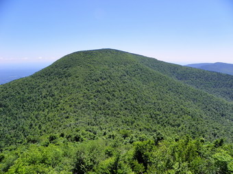 When the Batavia Kill Trail ended at the Escarpment Trail, we turned right and started up toward the summit of Blackhead Mountain. It was 10:00 AM as we started the ascent which begins gently but then becomes steeper with several switchbacks and one very nice lookout. The lookout is a good place to get a view of the Hudson River valley to the east and is important since the summit of Blackhead has no view. There are several rock scrambles along this approach including some that are nearly vertical. The ascent is about .8 miles and is over 1000 vertical feet. We stopped for pictures at the viewpoint at 10:20 AM and then headed up to the summit. We arrived at the summit at around 11:00 AM about 2.5 miles into the hike. After taking a break we started off again toward Black Dome. After only .4 miles, we stopped at 11:25 AM on the west face of Blackhead with a fantastic view of Black Dome immediate ahead and the entire Devils Path to our left toward the south. We spent a couple minutes taking pictures. Jane asked about on obvious rocky area on Black Dome and I said that was where we would be very soon. Looking across at Black Dome I always have the feeling that no one could climb such a big mountain. The feeling always passes but I hope it reflects the respect I have for the mountains. The trip down to the col was made difficult by the fact that the trail was a little overgrown, wet in spots and strewn with loose rocks and dirt. Along the way we met a group coming up Blackhead with the intention of heading down the other side. We exchanged information and the continued in our opposite directions. We hit the col at 11:40 AM and immediately started up Black Dome. The climb is much easier than Blackhead since the start is so much higher. There are some tricky rock scrambles and a nice viewpoint back to Blackhead - the same viewpoint that was visible from Blackhead.
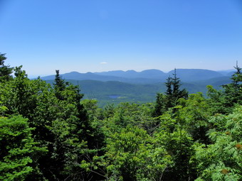 After leaving the viewpoint, we headed directly up to the summit of Black Dome to the rock shelf lookout toward the south. We arrived at 12:15 PM about 3.7 miles into the hike and decided to take a break for lunch. I took some pictures and shared a sandwich with Jane. After giving Sheba a drink, treats and part of my sandwich we pushed on to Thomas Cole. This part of the hike is the easiest but there are still a few rock scrambles in the way along the .75 miles stretch. There is no view from Thomas Cole so we turned around and headed back. We hurried through the descent back into the col with Black Dome and then pushed the ascent up to the summit. From the top of Black Dome we headed back down into the col. A group of three hikers from Albany was taking a break before starting back to the parking area. We talked briefly and then they started down ahead of us. We followed them soon after at about 2:10 PM and 5.7 miles into the hike. . The Black Dome Trail had been cleared of nettles and prickers for most of the length by a volunteer we had met before on Blackhead. The first part of the trail descends through several switchbacks before joining a woods road. Once on the road the trail becomes very rocky and difficult to walk. By 2:55 PM we had hiked 7 miles are were back at the junction with the Batavia Kill Trail. From here we headed back to the car over rocks that were no longer damp or slippery as they had been earlier. We arrived at the cars at 3:15 PM covering the 7.6 miles in 6 hours with over 2800 feet of elevation gain. We drove to Tannersville and had a very nice meal at Pancho Villa's before parting company.

![]()
![]() On Thursday, July 7th Cindy and I headed to Trout Pond to hike. It took us a while to decide where we were going so we did not arrive at the upper parking area until 10:30 AM. The temperature at this time was in the high 70's and predicted to climb into the upper 80's. We started down Russell Brook Road and immediately ran into a road crew from the Town of Colchester trying to smooth the gravel that makes up the road bed. They were also working to clear the ditches so that the water can drain. Hopefully this will prevent the road from washing out during the frequent and violent rain storms that have been occurring on a regular basis. As we walked down the road I could hear the brook and it sounded like the volume was pretty high. I had thought I would avoid taking pictures since I have so many of this area but I could not resist. I walked down the bank to a spot overlooking the upper falls and took some shots. Back on the road we walked down to the lower parking area and then down the wide snowmobile trail/road to the area of the lower falls. We passed by the falls as we had been there recently and started up to Trout Pond. We talked as we walked and soon we were at the outlet of the pond. After a brief stop for some pictures and a drink we headed for the upper end of the lake. The trail was VERY wet from the overnight rain. As we approached the lean-to, a young boy popped out of the bushes by the lake and started to walk toward the lean-to. I struck up a conversation and found the family camps there every 4th of July. Where the trail branches we headed to the right up the Trout Pond Trail toward Campbell Brook. It was about 11:20 AM and we had covered 2 miles.
On Thursday, July 7th Cindy and I headed to Trout Pond to hike. It took us a while to decide where we were going so we did not arrive at the upper parking area until 10:30 AM. The temperature at this time was in the high 70's and predicted to climb into the upper 80's. We started down Russell Brook Road and immediately ran into a road crew from the Town of Colchester trying to smooth the gravel that makes up the road bed. They were also working to clear the ditches so that the water can drain. Hopefully this will prevent the road from washing out during the frequent and violent rain storms that have been occurring on a regular basis. As we walked down the road I could hear the brook and it sounded like the volume was pretty high. I had thought I would avoid taking pictures since I have so many of this area but I could not resist. I walked down the bank to a spot overlooking the upper falls and took some shots. Back on the road we walked down to the lower parking area and then down the wide snowmobile trail/road to the area of the lower falls. We passed by the falls as we had been there recently and started up to Trout Pond. We talked as we walked and soon we were at the outlet of the pond. After a brief stop for some pictures and a drink we headed for the upper end of the lake. The trail was VERY wet from the overnight rain. As we approached the lean-to, a young boy popped out of the bushes by the lake and started to walk toward the lean-to. I struck up a conversation and found the family camps there every 4th of July. Where the trail branches we headed to the right up the Trout Pond Trail toward Campbell Brook. It was about 11:20 AM and we had covered 2 miles.
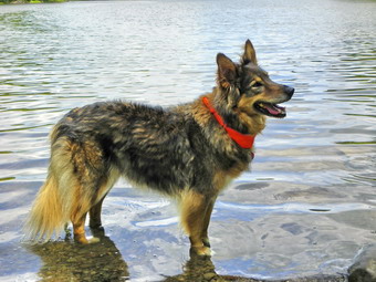 We had not hiked the trail that leads to Campbell Brook Road for some time. The first .8 miles of the trail is all uphill and rises about 450 feet to the top of a hill. The trail is not used much and would be completely grow in except for the fact that it also acts as a snowmobile trail. At one point, near the top, another snowmobile trail marked "21" headed off to the right. We stayed to right on the blue blazed hiking trail. From here the trail descends to an area where it crosses two brooks on newly constructed bridges. After that it ascends slightly to meet Campbell Brook Road. The trail is easy to follow but is overgrown in any open areas with prickers and nettles. At Campbell Brook Road I had intended to hike another mile up to Campbell Mountain Road and then use Morton Hill Road to get back to the car. Cindy decided that we would turn right on Campbell Brook Road until it meets Morton Hill. This cut a few miles from the hike but it was hot and I really didn't object. For about .9 miles Campbell Brook Road and Morton Hill Road ascend a hill. After that the next 2.4 miles is all downhill back to the car. My feet were starting to hurt and it was hot. I am not a big fan of road walking in the sun even though it is fast. We were back at the car just passed 1:30 PM covering 7.1 miles in just over 3 hours!
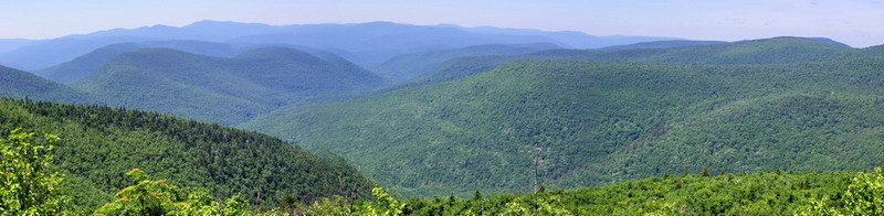
![]()
![]() On Tuesday, July 5th I had the idea that I wanted to return to Notch Lake and hike Plateau and maybe Sugarloaf from there. I don't like paying the $6 fee just to park but I hadn't hiked Plateau from the lake in some time and the steepness of the trail somehow appealed to me. The forecast was for sunny weather with temperatures in the 80's. I had some errands to do in the morning so we did not arrive until 10:30 AM. There were no cars at Slide and only two at Panther. The Notch Lake parking area had a few cars. Sheba and I got right on the trail by crossing the road where I signed the register. We start UP the trail toward the top of Plateau. This trail is steep despite the switchbacks and since I was trying to keep a good pace. I was soon a little winded. A couple of places opened up in the foliage so that I could take some pictures. As we climbed over some rocks I began to think about the discussion I had with Hermit on Saturday about rattlesnakes on Plateau. I decided Sheba should follow me and I was very careful as we walked along. The bottom line was that we saw a lot of toads of different sizes but no snakes of any kind. We did walk across the slide on Plateau on the way to the top. As the trail flattened a little near the top, there were some wet spots but otherwise this part of the trail was dry. There we also fewer insects than I expected. At the very top of the climb is a vertical scramble up and over some rocks To Orchard Point. I boosted Sheba up and then got myself on top. We had climbed 1650 feet in 1.2 miles taking a little over an hour including our stops.
On Tuesday, July 5th I had the idea that I wanted to return to Notch Lake and hike Plateau and maybe Sugarloaf from there. I don't like paying the $6 fee just to park but I hadn't hiked Plateau from the lake in some time and the steepness of the trail somehow appealed to me. The forecast was for sunny weather with temperatures in the 80's. I had some errands to do in the morning so we did not arrive until 10:30 AM. There were no cars at Slide and only two at Panther. The Notch Lake parking area had a few cars. Sheba and I got right on the trail by crossing the road where I signed the register. We start UP the trail toward the top of Plateau. This trail is steep despite the switchbacks and since I was trying to keep a good pace. I was soon a little winded. A couple of places opened up in the foliage so that I could take some pictures. As we climbed over some rocks I began to think about the discussion I had with Hermit on Saturday about rattlesnakes on Plateau. I decided Sheba should follow me and I was very careful as we walked along. The bottom line was that we saw a lot of toads of different sizes but no snakes of any kind. We did walk across the slide on Plateau on the way to the top. As the trail flattened a little near the top, there were some wet spots but otherwise this part of the trail was dry. There we also fewer insects than I expected. At the very top of the climb is a vertical scramble up and over some rocks To Orchard Point. I boosted Sheba up and then got myself on top. We had climbed 1650 feet in 1.2 miles taking a little over an hour including our stops.
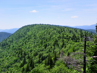 At the top of the climb there is a flat space that acts as a lookout. The views were very good this day if a little green. The view directly north showed Hunter mountain where I could see the ski equipment at the top of the slopes and the fire tower at the summit. A little to the west was Westkill. I took many pictures and several showed the layers of mountains one behind the other. I tried some panoramic shots and two came out very nicely. After spending some time at this lookout, we headed toward the highest spot on Plateau which is more than 2 miles away along the top of the mountain. As the name suggests the hike is almost flat although the elevation gain from the top of the climb to the summit is 225 feet. Not far passed the top of the climb and the northward facing lookout is another open spot that faces east called Danny's Lookout. Perhaps the most prominent feature from the viewpoint is Kaaterskill High peak and Round Top. I took more pictures from here before continuing on to the summit. The long walk to the highest point on Plateau starts out with a hike through some hardwood trees, small clearing and fir trees. The further along you get the more the trees close in and become almost exclusively fir. Several places along the trail there are glimpses of light on the right and some possible viewpoints but most are obscured by vegetation and offer no real views. At 2.75 miles from the beginning of the hike we hit the "new" extension to the Warner Creek trail. By this time I had decided that I would not do Sugarloaf. It was getting late and I just didn't feel like descending Plateau and the ascending Sugarloaf just to have to repeat the processes to get back to the car. We continued to walk to the highest point on the trail and then down the other side to the large boulders that lookout over Sugarloaf. We had already hiked 3.4 miles and it was a little before 1:00 PM. We stopped here to get a snack and So that I could take some pictures. Afterward we headed back down the Devil's Path for about .65 miles and turned left onto the Warner Creek Trail.
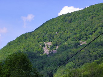 I had been on the Warner Creek Trail several times but had usually ascended it. At the beginning the trail descends gently through some fir trees but at some point the descent is pretty steep. About .5 miles down this trail from the Devil's Path is the best viewpoint on the whole trail. The lookout is an open, flat rock and I took pictures of Silver Hollow and some back up toward Plateau. The pictures of Plateau clearly show the reason for the name. We continued own the trail and the going was slower than I thought especially on the steeper sections of Daley Ridge which were mostly damp dirt. We passed the spring but did not go to it. The trail turned out to be longer than I remembered! About 2 miles from the Devil's Path are several marked vistas with side trails. None of these was worth the list as the views were all blocked by the tree. In another .3 miles there are a series of switchbacks down the steepest sections through and along some rock ledges. Three miles from the Devil's Path and around 7 miles into the hike we hit the trail that follows Silver Notch Road, a woods road, down to Notch Inn Road. This part of the trail was the wettest with a lot of flowing water. At the end of Notch Inn Road, I put Sheba on her leash and we walked about 1.2 miles back to the car on Route 214. Along the way we stopped so that I could take pictures of the slide that was clearly visible on Plateau. I also took pictures of the beaver pond with its dam and lodge. Back at the car we met the only other hiker of the day, a woman from Woodstock who had just come back from the Hunter fire tower. We had hiked 9.2 miles in 5.5 hours. I was glad I had not included Sugarloaf in the hike!
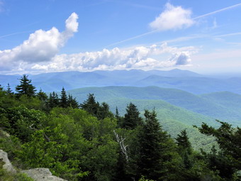
![]()
![]() On Saturday, July 2nd Jane Doe and I had a plan to meet at the end of Moonhaw Road at 9:00 AM and bushwhack Friday and Balsam Cap with a stop of the B-25 crash. Jane has to drive from Westchester County and I thought the later start might also allow the woods to dry out a little from the rain on Friday night. We made the plant on Wednesday and on Thursday I saw that Hermit had made mention of hiking the VanBenschoten Trail on Saturday. I sent a personal message to Ralph asking if Jane and I could tag along and he said that is was okay. Jon, the person that was accompanying Ralph, had only hiked Mt. Tremper before and I wondered if he realized what he was getting into. I called Jane to break the news and ask if there was any way she could get to Moon haw by 7:15 AM. I was ready for her to say "NO!" because of the long drive but she immediately consented.
On Saturday, July 2nd Jane Doe and I had a plan to meet at the end of Moonhaw Road at 9:00 AM and bushwhack Friday and Balsam Cap with a stop of the B-25 crash. Jane has to drive from Westchester County and I thought the later start might also allow the woods to dry out a little from the rain on Friday night. We made the plant on Wednesday and on Thursday I saw that Hermit had made mention of hiking the VanBenschoten Trail on Saturday. I sent a personal message to Ralph asking if Jane and I could tag along and he said that is was okay. Jon, the person that was accompanying Ralph, had only hiked Mt. Tremper before and I wondered if he realized what he was getting into. I called Jane to break the news and ask if there was any way she could get to Moon haw by 7:15 AM. I was ready for her to say "NO!" because of the long drive but she immediately consented.
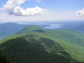 I got up at 5:00 AM and was driving out to Liberty by 5:35 AM with Sheba in the back seat. By the time I got to Grahamsville, I remembered that the drive was only about an hour for me. I hoped Jane could find the trailhead and would be on time. When I arrived at the parking area Jane was already there having found the parking area with little trouble! Hermit and Jon arrived just after 7:00 AM and we crossed the bridge over Wittenberg Creek and started up the old woods road. Hermit gave us same historical information as we recrossed the creek. The land was once owned by the Moonhaw Club. Mr. VanBenschoten was the caretaker and his wife cooked. Eventually passed into the hands of Nelson Shultis. After Mr. Shultis logged the land, it passed to New York State. The "mansion" at the end of Moonhaw Road stands where one of the club buildings was once located. The hike was going pretty well down low with some wet spots and patches of nettles. Jon was in shorts and Jane lent him her gaiters to alleviate the nettle experience. The lower part of the "trail" follows old logging roads. We were following faint orange blazes last placed the a Boy Scout Troop. At some point we hit the steeper part of the trail followed by the steepest part! Some of this required hanging onto roots and branches and pulling ourselves up the slope. Jane and I were getting tired nut Hermit is amazing and Jon, on his second hike, was right with him. We finally were in sight of the trail after pushing through a little thick stuff near the top. It took us almost 3 hours to do the 2.5 miles to the ridge. Once on the trail he turned right and headed toward Wittenberg.
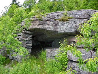 Hiking the ,4 miles over to Wittenberg seemed easy! We stopped at the top of Wittenberg to get a snack and take pictures. The view was only a little hazy but I got some good shots. There were three other people at the top along with a Blue Dane. The Blue Dane was BIG with red rimmed eyes and I thought "Two heads short of Cerberus." Someone pointed out a snake in the rock crevice. It was hard to see the markings to identify the species. After our "rest" at the summit, Hermit took us down to a cave/shelter below the summit. Not too many people know about this place. (I guess a lot more know now!). I cannot reveal the exact location as we were sworn to secrecy. There was a small tin box where we signed our names. After a short break to enjoy a different view and to take pictures we were off again for Cornell. We walked back to the top of Wittenberg and over the Bruin's Causeway to Cornell. I was already feeling a little tired and I knew Jane felt the same way. Hermit and Jon seemed unaffected! We all got up the V notch on Cornell without many problems. Even Sheba only need an initial boost and then scrambled up the crack. We stopped at the overlook just to the left of the crack to take some pictures. This viewpoint is better than the other one near the top of Cornell. The views of Wittenberg and the Ashokan were very nice. We walked on to the other viewpoint on Cornell where I hatched a brilliant plan. I was pretty sure Jane and I would not be able to tackle Slide AND return the way we had come which was Hermit's plan. Jane cell phone had service so I called my wife to give Jane and I a ride back from the main Slide parking area. Cindy agreed so the plan was made.
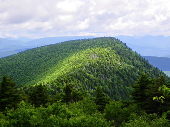 As We started down Cornell toward Slide, my mood was much improved and my legs began to feel better. Could I really make it back with Hermit and Jon? I thought I probably could but decided to stay with the new plan. We stopped at the viewpoints that look out toward Slide and the surrounding valleys and I took some shots. Descending into the Col between the two mountains seemed easy! As we started up Slide, I was sure that my new plan was the proper one as my legs were dead. There was a group of people in the Col and we said "Hi" as we passed through. After a stop for lunch, we hit the two or three scrambles before the ladders on slide. These scrambles can be fun but they also have workarounds which I though Sheba and I would use. As it turned out we all made it up the scrambles OK. The last part of the climb up to the ladders on Slide was a grind for me but we were soon at the spring. Sheba got a drink and we stopped for a short rest. We stop at the ladders for some pictures and to look back at Cornell. Climbing the ladders and the subsequent rock scrambles actually went quickly and my legs were feeling better. At the top of Slide we paused for pictures. There were quite a few people at the top and Jane asked someone to take a picture of the five of us. We said goodbye to Jon and Hermit and parted ways. Jane and I continued down Slide toward Route 47 and Hermit and Jon headed back the way we had come.
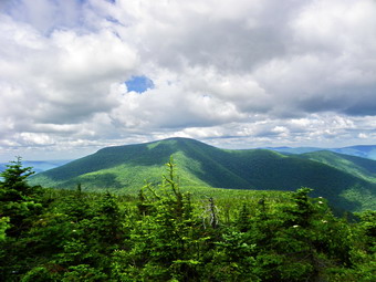 The walk down Slide was pretty easy. We stopped at the viewpoint toward Giant Ledge and Panther and I took a few pictures. As we continued down, we met a lot of people heading up. Most made positive comments about Sheba which I appreciated. We began to meet people I knew and had mentioned previously on the hike. The first was a former student who asked how far it was to the top. I had mentioned Robert Moses from Andes Hikers to my partners on the hike. We met a group coming up led by ... Robert Moses. We talked for a moment and he offered us Klondike bars but hiking back to the top was NOT something I would do for a Klondike bar! I also talked about Hoosier and Jay H from the ADKHighPeaks forum both of whom I had hiked with before. A little further down the trail we met up with ... Jay H and Hoosier. We continued down the trail passing many people coming up and a few going down. The main trail on Slide is NOT one of my favorites especially on the way down. The trail has too many rocks that slip and roll under foot. Soon we came to the woods road and turned right. It was only a short walk until we turned left to continue down to the main parking area. My wife was waiting in the parking area. We drove from the Slide parking area through Grahamsville and out the Peekamoose Road. Jane and I were kidding each other about beating Hermit and John back to the cars! When we got to the end of Moonhaw Road, Hermit and Jon had just arrived! They made the trip back from Slide, over Cornell and down the VanBenschoten Trail in 2.5 hours! Jane and I had hiked 8.7 miles in 8 hours and 20 minutes with a total elevation gain of 4300 feet. Hermit invited us back to his house but I was too tired to accept. I definitely need to hike more on the 35s and up my speed although I doubt I will ever be as fit as Ralph.
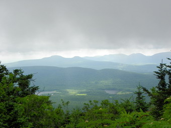
![]()
![]() On Wednesday, June 29th I decided I wanted to do a longer hike and get in some elevation also. The only peaks I "needed" for the grid for June were bushwhacks. Torrential downpours the day before convinced me that battling prickers and nettles is bad but even worse when they are wet and the footing is questionable. I decided to hike the Blackhead Range from Barnum Road since I had not done it in some time. The weather forecast was for temperatures in the mid-seventies and mostly sunny skies. When I awoke in the morning, there was a heavy haze hanging over Livingston Manor. This is not unusual and often the haze disappears as I drive out of the valley in the morning. I was aiming to get started by 8:00 AM so pulling out of Livingston Manor at 8:15 AM was a real accomplishment! As I drove out DeBruce Road I noticed two things - the skies remained overcast and I was very tired. As I turned onto the Frost Valley Road and drove toward Big Indian, neither of these things changed. I began to feel like turning around and going home to take a nap! The Slide and Panther Mountain lots had one or two cars parked. As I approached Route 28, I pulled off the road at the little convenience store and closed my eyes. I rested for no more than 10 minutes but after that felt considerably better. Since I had the Blackhead Range for June, I decided I would go hike as many of the three peaks as I wanted and THEN return home for my nap! We arrived at the end of Barnum Road just before 10:00 AM and started to hike almost immediately. The first .5 miles is uphill along an old road and trail. It was wet with running water and washed out. The trail is sometimes in the "stream bed" and sometimes on the bank. At the end the trail turns sharply left and there is a sign in box.
On Wednesday, June 29th I decided I wanted to do a longer hike and get in some elevation also. The only peaks I "needed" for the grid for June were bushwhacks. Torrential downpours the day before convinced me that battling prickers and nettles is bad but even worse when they are wet and the footing is questionable. I decided to hike the Blackhead Range from Barnum Road since I had not done it in some time. The weather forecast was for temperatures in the mid-seventies and mostly sunny skies. When I awoke in the morning, there was a heavy haze hanging over Livingston Manor. This is not unusual and often the haze disappears as I drive out of the valley in the morning. I was aiming to get started by 8:00 AM so pulling out of Livingston Manor at 8:15 AM was a real accomplishment! As I drove out DeBruce Road I noticed two things - the skies remained overcast and I was very tired. As I turned onto the Frost Valley Road and drove toward Big Indian, neither of these things changed. I began to feel like turning around and going home to take a nap! The Slide and Panther Mountain lots had one or two cars parked. As I approached Route 28, I pulled off the road at the little convenience store and closed my eyes. I rested for no more than 10 minutes but after that felt considerably better. Since I had the Blackhead Range for June, I decided I would go hike as many of the three peaks as I wanted and THEN return home for my nap! We arrived at the end of Barnum Road just before 10:00 AM and started to hike almost immediately. The first .5 miles is uphill along an old road and trail. It was wet with running water and washed out. The trail is sometimes in the "stream bed" and sometimes on the bank. At the end the trail turns sharply left and there is a sign in box.
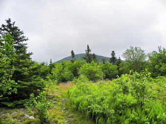 The trail begins a long uphill section at this point but none of this is very steep except for a few short rock scrambles. I was watching for a lookout part way up but missed it. After At .8 miles the trail goes through a series of switchbacks and then straightens out again. The skies continued to be overcast and were almost threatening rain. Occasionally the sun seemed to break through and then go back under a bank of clouds. There were few views along the way due to the lush vegetation spurred on by the recent rains. The vegetation along the trail is beginning to close in many places bringing the nettles all that much closer. I was wet after less than a mile despite the fact I wore gaiters. Many sections of the trail had running water but the worst part were the flatter sections with frequent muddy spots. None of the spots were enormous but they were bad enough for me to want to avoid them and they interrupted the hike. At more than one point I thought I might just hike to the summit of Cole and then bail! At 1.4 miles I approached a steeper climb to around 3300 feet. I knew this wasn't Thomas Cole. What I remembered after getting to the top was that before ascending Cole you must ascend and then descend the Caudal and the Camel's Hump! After about 2 miles I was at the top of the Camel's Hump and starting down the other side. There was a sort of view of Thomas Cole through the bushes but I couldn't take any pictures. The trail got even narrower and the mud in the col was pretty bad. One bright note was the absence of insects! Soon we were on the flat, open area between The Hump and Cole. I tried to see if could get a picture but the trees and the cloud hanging on the mountain conspired against me.
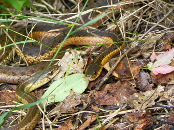 We were ready to make the final push up Thomas Cole. On the way up we stopped at the small viewpoint which is a short walk off the trail. There was a nice view but much of it was hidden by the clouds hanging low. I took a few shots and hoped it would clear by the time we started back. We hit the top of Thomas Cole at about 3 miles and around noon. The climb up Cole had been less muddy and I was in the mood to at least hike over to Black Dome. The hike to Black Dome is only about .7 miles and I always think of it as flat. The elevation change is just enough to consider Cole a separate peak but there several steeper spots and one nice rock scramble. As I descended these areas I was reminded of how slippery everything was due to the recent rain and high humidity. The is section wet well despite a couple of slips and by 12:25 PM we were at the lookout to the south about 3.7 miles into the hike. There were two other hikers there and I talked to them for a short time. The skies were still overcast and the views very limited. I decided that, although I wanted a few more miles, I would not try the descent down Black Dome to Lockwood Gap. We turned around and headed back to the car. The first part of the descent went quickly. The views from the lookout had no improved so we bypassed it rather quickly. It did seem that the section from the Hump down the Caudal went very slowly. On the way down I did find the lookout I missed on the way up. As I stepped out onto the a group of 4 or more snakes slithered into the bushes. A little farther over another group of 4 did the same! I took a few pictures and as I packed up to go the one group of snakes returned. I got the camera back out to take some pictures. After that it was down the last rock scramble and back toward the car. This section seemed to take a long time. We were back at the car by 2:45 PM taking almost 5 hours to cover the 7.2 mile hike. We did stop several times but when I hike the 35s I am always reminded that they are different than any other hikes I do.
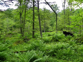
![]()
![]() On Monday, June 27th I had planned to get out on one of my long and fast peakbagging trips. However, Dr. Kudish was still around and planning to bushwhack to some wetlands east of Mongaup Pond. Since this was a totally different aspect of his work, I could not pass up the opportunity to hike with this legend. The plan was to meet at Morgan Outdoors around 8:30 AM and drive to Mongaup Pond to start the hike around 9:00 AM. We met and got a late start. I thought the plan was to park on Flugertown Road and hike in from that direction. This would be a shorter hike and avoid the $8 parking fee. Somehow the decision was made to park at Mongaup Pond, pay $8 for the privilege and then hike the longer distance to get to our destination! We arrived at campsite 38 at 9:30 AM and were soon on the trail. We started on the snowmobile trail that leaves the campsite and headed first east and then north. After about .8 miles we were at the junction with the Long Pond-Mongaup Trail and turned right to head generally southeast toward our destination. Along the way Dr. Kudish noted some of the larger trees and a nice stand of black cherry. We also saw several woods roads that headed off from the trail in different directions. We walked on the trail for about 1.33 miles to a small bridge. Our elevation was, at that point, about the same as the pond but we had hiked up and over a hill to get there. The stream that the bridge crossed appeared to be the outlet stream for the wetlands so we turned right off the trail and followed the stream southwest toward our destination.
On Monday, June 27th I had planned to get out on one of my long and fast peakbagging trips. However, Dr. Kudish was still around and planning to bushwhack to some wetlands east of Mongaup Pond. Since this was a totally different aspect of his work, I could not pass up the opportunity to hike with this legend. The plan was to meet at Morgan Outdoors around 8:30 AM and drive to Mongaup Pond to start the hike around 9:00 AM. We met and got a late start. I thought the plan was to park on Flugertown Road and hike in from that direction. This would be a shorter hike and avoid the $8 parking fee. Somehow the decision was made to park at Mongaup Pond, pay $8 for the privilege and then hike the longer distance to get to our destination! We arrived at campsite 38 at 9:30 AM and were soon on the trail. We started on the snowmobile trail that leaves the campsite and headed first east and then north. After about .8 miles we were at the junction with the Long Pond-Mongaup Trail and turned right to head generally southeast toward our destination. Along the way Dr. Kudish noted some of the larger trees and a nice stand of black cherry. We also saw several woods roads that headed off from the trail in different directions. We walked on the trail for about 1.33 miles to a small bridge. Our elevation was, at that point, about the same as the pond but we had hiked up and over a hill to get there. The stream that the bridge crossed appeared to be the outlet stream for the wetlands so we turned right off the trail and followed the stream southwest toward our destination.
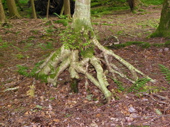 The wetland was a little more than half a mile up the stream and the walk was a pleasant one through mostly open hemlock forest. When we arrived, we surveyed the area and then decided to walk around the edge anticlockwise. I took some pictures from the southeast corner where we were and then started the hike around. The margin between the wetland and dry ground was pretty clear. As we walked around the small area, I walked to the edge to take pictures several times.There appeared to be a defined channel through the middle. There were some large yellow birch in the middle of the wetlands as they will grow in this environment. Opposite our point of first contact was an inlet stream which was easily crossed. No one else seemed interested in where the stream originated so I decided to come back later to take a look. We continued on around to our beginning point and took a break for lunch. Afterward Dr. Kudish donned his wading boots and entered the wetlands. Using his long bamboo walking stick he probed the area taking some time to do a thorough job. There was only one spot that proved to be sufficiently deep to be of interest. The rest of the places and most of the wetlands lies directly on top of glacial till. This lack of depth means there will not be enough peat formation to contain interesting fossil material. When Dr. Kudish returned to shore, we decided to head to a beaver meadow south of Sand Pond to check out the situation there. Dr. Kudish did not expect to find much but wanted to do a quick survey. We headed back to the bridge on the main trail, turned left and almost immediately turned right off the trail and into the woods heading northeast.
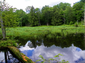 As we walked through the woods we crossed an overgrown but well-defined woods road which we though we might investigate on the way back. A we continued on, we found a stream flowing to the northeast and east.At first we followed it and then crossed over to the other side. When I spotted some "open ground", we headed more north and were soon at the edge of the beaver meadow. In fact, there was some meadow and some open water. I took some pictures of what turned out to be mountain laurel while Dr. Kudish surveyed the plant life. He found a small seedling which appeared top be red spruce but could find no other trees of this species. We crossed over to the other side of a small stream and found more red spruce seedlings and, finally, a single adult tree. The beaver meadow is at the southern end of Sand Pond and the outlet stream, Butternut Brook, flows through the middle of it. Dr. Kudish and Kurt Knuth stopped to survey some leather leaf and other species while I scouted ahead. Butternut Brook became more defined and made a definite turn to the southeast. At this turn was a small beaver pond with a lodge and plenty of evidence of beaver activity. After completing their plant survey, Kurt, Dr. Kudish and I started to walk back to the main trail along the brook. There were many large trees of different species along the way and we measured many of them. Some where close to 40 inches in diameter. The age of the tree depends greatly on the species and the conditions under which it grows. Many of these trees are between 150 years and 250 years old. When we hit the main trail, we took a break, measured some more trees and then headed back to the car. As always the walk back seemed long but we kept a pretty good pace. At times, it would have been shorter to bushwhack over a hill right to the car but we all agreed to stay on the trail. When we got back to the car, I was surprised to see that we had hiked 8.2 miles and had been out for 5.5 hours. It seemed like a much shorter time and I would like to hike with Dr. Kudish again. If you ever have the chance to hike with this knowledgeable man, I suggest you drop everything else to do so. Dr. Kudish will be lecturing at Morgan Outdoors sometime this summer or fall.
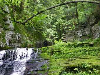
![]()
![]() On Sunday, June 26th the sun finally reappeared and the weather forecast showed no hint of rain. I was ready to hike a "long one" but Morgan Outdoors was sponsoring a hike at Russell Brook with Dr. Mike Kudish. Dr. Kudish is a Professor Emeritus who taught at Paul Smith's College for many years. He is THE expert of the forests in the Catskills. His research is diverse but concentrates on the development of the forest, first growth forests, bogs and the effect of humans on the forest. A complete explanations the depth and breadth of his work would be impossible. His latest book "Where Did The Tracks Go - In the Catskills" continues the story of the importance of railroads in the Adirondacks and Catskills. When I hike, I usually have a destination in mind and want to hike log and fast to get to my destinations. I have wanted to hike with Dr. Kudish for some time and was grateful for this opportunity. This hike would be specifically directed toward the effect of the acid factories and the dye works along the Beaverkill at Butternut Grove and along Russell Brook. This area was just one of the many areas that experienced extensive logging during the late 19th and early 20th centuries. To move the logs cut to the factories a narrow gauge railroad was constructed on Russell Brook by George Treyz. The group finally assembled at the lower Russell Brook parking area at about 1:40 PM. We walked down Russell Brook Road for a short distance to a woods road that was on the left. Only a little distance into the woods were the remains of the Russell Brook school. This small school was one of the many that served small communities and may have educated the children of loggers and factory workers who lived in the area. We followed the woods road back across Russell Brook Road and down to the stream. Clearly visible on the other side was a stone abutment. This shows that the road crossed the stream on a bridge. On the other side we could barely make out a clearing where logs were stockpiled until they could be shipped to the factories by train.
On Sunday, June 26th the sun finally reappeared and the weather forecast showed no hint of rain. I was ready to hike a "long one" but Morgan Outdoors was sponsoring a hike at Russell Brook with Dr. Mike Kudish. Dr. Kudish is a Professor Emeritus who taught at Paul Smith's College for many years. He is THE expert of the forests in the Catskills. His research is diverse but concentrates on the development of the forest, first growth forests, bogs and the effect of humans on the forest. A complete explanations the depth and breadth of his work would be impossible. His latest book "Where Did The Tracks Go - In the Catskills" continues the story of the importance of railroads in the Adirondacks and Catskills. When I hike, I usually have a destination in mind and want to hike log and fast to get to my destinations. I have wanted to hike with Dr. Kudish for some time and was grateful for this opportunity. This hike would be specifically directed toward the effect of the acid factories and the dye works along the Beaverkill at Butternut Grove and along Russell Brook. This area was just one of the many areas that experienced extensive logging during the late 19th and early 20th centuries. To move the logs cut to the factories a narrow gauge railroad was constructed on Russell Brook by George Treyz. The group finally assembled at the lower Russell Brook parking area at about 1:40 PM. We walked down Russell Brook Road for a short distance to a woods road that was on the left. Only a little distance into the woods were the remains of the Russell Brook school. This small school was one of the many that served small communities and may have educated the children of loggers and factory workers who lived in the area. We followed the woods road back across Russell Brook Road and down to the stream. Clearly visible on the other side was a stone abutment. This shows that the road crossed the stream on a bridge. On the other side we could barely make out a clearing where logs were stockpiled until they could be shipped to the factories by train.
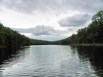 The group walked back up to the road that leads to the falls and the trail around Trout and Mud Ponds. As we crossed the bridge, Dr. Kudish stopped to talk about invasive species spurred on by a tall stand of Japanese knotweed. He mentioned that many species of weeds and grasses that we consider native plants are really foreign "invaders". Many of these plants were brought over from Europe in the hay that was used to feed livestock. We walked over to the falls to take some pictures and observe the lower and upper dams. These dams were used to control the water flow on the brook primarily for power generation downstream near Butternut Grove. After this, we headed up to Trout Pond. Along the way I took the path down to the campsites and discovered that a road leaves the other end of the campsite. One branch heads down to the stream while the other winds around to meet the main trail. After stopping at the shores of Trout Pond near the outlet we continued toward the inlet. Along the way Dr. Kudish pointed out a couple of woods roads that branch off on the right of the trail. These roads have a gentle slope and have rocks pushed to the side. It is likely that these are logging roads that may date back to the acid wood era. The acid factories took hardwood timber and turned it into charcoal. They distilled the wood into methanol, acetone and many other products. One dye factory on the Beaverkill produced most of the khaki dye used for World War I uniforms.
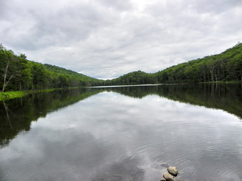 At the head end of the lake we stopped for a snack. Dr Kudish discussed the importance of the forest around Russell Brook in the rethinking of his theories about human effects on the forests. The area around Arkville where he lives is another area that had acid factories. However, the forests in the two areas differ greatly. Around Arkville, the forest have an abundance of oak, hickory and chestnut trees. The Russell Brook area has more beech, maple and black cherry. Based on his observations around Arkville, Dr. Kudish expected to find similar forests around Russell Brook. He now feels the difference is the influence of the Native Americans that preceded the acid factories. There was much greater Native American activity in the valleys around Arkville and Margaretville than in the Russell Brook area. These Native Americans mostly likely planted the oaks, hickories and chestnuts to harvest the nut crop for themselves and their livestock. Dr. Kudish is still investigating this hypothesis but will likely rewrite his Catskill Forest book to reflect this and other newer information. We arrived back at the car around 5:00 PM after a thoroughly enjoyable time.