
What You Missed
Spring 2013
Spring 2013
![]()
![]()
![]()
![]()
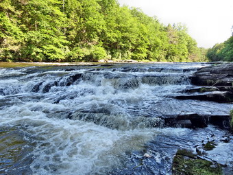
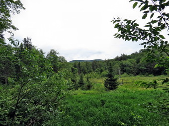
![]() On Thursday, June 20th, I was tired from six hours of trail maintenance at Frick and Hodge Ponds the day before. However, since I had not taken Sheila the day before I felt I "owed" her a day out. I decided that I had not been the Neversink Unique Area in some time and that I would like to visit High Falls. I left Livingston Manor rather early hoping to visit Mullet Falls before the sun was too high in the sky. To take pictures of this falls the sun has to be low in the sky in the morning or it has to be well after noon. We arrived at the parking area at the end of Katrina Falls Road at 8:30 AM to find four fishing buddies getting ready to try trout fishing in the Neversink. They also had a dog with them so I wanted to get well ahead of them. The temperature was still in the mid 50's but I stowed my light jacket in my pack and headed out with Sheila on her leash. As we started down the road toward the Neversink, I released Sheila and she ran ahead to explore. At the first trail junction we turned left to parallel the river. I could hear Wolf Brook long before we were at the foot bridge that crossed it. I stopped at the bridge to take a few pictures but the sunlight was already very bright. I had been hoping that the forecast for cloudy skies would be correct! We crossed the brook and headed up a small hill to the next trail junction. I decided to bear to the right to parallel the river. This would allow me to decide whether or not I should visit Mullet Falls first. In the back of my mind was the fact that I wanted to get to Denton Falls before the fisherman did. The walk on the trail was pleasant and was mostly dry which was a welcome change from the two previous days. I could hear the Neversink roaring below. Soon we were approaching Mullet Brook and when we got there I dropped my pack to take a few pictures. The light was not cooperating so I was only able to take a few good shots. We crossed the footbridge and I looked upstream to see that the sun was much too high to make an immediate visit to Mullet Falls worthwhile. When we got to the junction with the spur trail to Denton falls, we turned right and headed down to the Neversink.
On Thursday, June 20th, I was tired from six hours of trail maintenance at Frick and Hodge Ponds the day before. However, since I had not taken Sheila the day before I felt I "owed" her a day out. I decided that I had not been the Neversink Unique Area in some time and that I would like to visit High Falls. I left Livingston Manor rather early hoping to visit Mullet Falls before the sun was too high in the sky. To take pictures of this falls the sun has to be low in the sky in the morning or it has to be well after noon. We arrived at the parking area at the end of Katrina Falls Road at 8:30 AM to find four fishing buddies getting ready to try trout fishing in the Neversink. They also had a dog with them so I wanted to get well ahead of them. The temperature was still in the mid 50's but I stowed my light jacket in my pack and headed out with Sheila on her leash. As we started down the road toward the Neversink, I released Sheila and she ran ahead to explore. At the first trail junction we turned left to parallel the river. I could hear Wolf Brook long before we were at the foot bridge that crossed it. I stopped at the bridge to take a few pictures but the sunlight was already very bright. I had been hoping that the forecast for cloudy skies would be correct! We crossed the brook and headed up a small hill to the next trail junction. I decided to bear to the right to parallel the river. This would allow me to decide whether or not I should visit Mullet Falls first. In the back of my mind was the fact that I wanted to get to Denton Falls before the fisherman did. The walk on the trail was pleasant and was mostly dry which was a welcome change from the two previous days. I could hear the Neversink roaring below. Soon we were approaching Mullet Brook and when we got there I dropped my pack to take a few pictures. The light was not cooperating so I was only able to take a few good shots. We crossed the footbridge and I looked upstream to see that the sun was much too high to make an immediate visit to Mullet Falls worthwhile. When we got to the junction with the spur trail to Denton falls, we turned right and headed down to the Neversink.
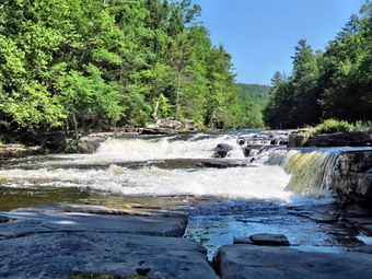 The walk down to the falls is only about .25 miles and we arrived at 9:10 AM after hiking about 1.7 miles. I dropped my pack and started to take some pictures. The water was high and looked very "clean" but the sun was at a bad angle upstream and the sky was "washed out". We walked down to the rock shelf below the falls and I took some more pictures. Sheila looked like she wanted to jump in but I discouraged her as the water is deep and was flowing very fast. I shouldered my pack and we headed back up to the main trail. There was still no sign of the fisherman as we turned right onto the main trail and then turned to the right at the next trail junction to head down to High Falls. Over the next 2.1 miles the trail descends and ascends some small hills as it parallels the river. Within the first .7 miles we ran into six blowdowns of various sizes. One new section was close to the trail junction. Several large evergreen trees had fallen along the trail completely blocking it for 50 feet or more. I made a note to report this to the NYNJTC. Parts of this trail were wet with a few small streams but they were easy to avoid or cross. The mountain laurel was just coming into full bloom and was beautiful as it lined most of the trail. The walk seemed to go quickly although parts of the trail were grown in with laurel and other shrubs. Along the way we came across a rather large garter snake on the trail. I was able to get one picture before my shadow caused it to slither off into the brush. Soon we were walking down to High Falls and the roar was very loud. We arrived at 10:30 AM at the edge of the water where we were able to walk along some rocks to get to the rock shelves that are even and below the falls. I dropped my pack and took out the camera. By this time the sky was a pretty blue but still lacked some puffy clouds. I took a lot of pictures before being satisfied that I had photographed the falls and the river from every angle. The weather was warm but not too warm and there were not too many bugs. We headed back up the trail to retrace our steps.
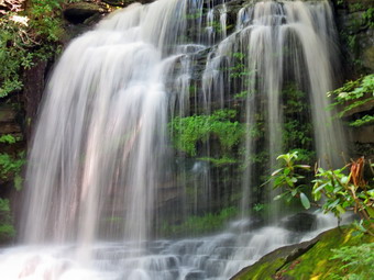 As we hiked back along the trail we repeated the ups and downs that we had experienced on the way out. I used my GPS to mark most of the blowdowns. I was surprised to find another snake sunning itself in the trail. This one stuck around for me to take more pictures and only moved when Sheila stepped on it. When we were almost to the trail junction to Mullet Falls, I looked up to see two trail runners coming toward us! I leashed Sheila and we stepped to the side of the trail as they passed. At the trail junction we turned right to start the loop back and to visit Mullet Falls. The spur trail to Mullet Falls came up within a few hundred feet and we turned to the left and walked down to the falls. When we arrived a father and his young son were already there so I leashed Sheila to a tree before heading down to take pictures. As I approached the stream I found a pair of sunglasses which I returned to the father. I tried to take some picture from the rocks in front of the falls but it was obvious that the sun was at the wrong angle. I walked back down to the stream and up the side of the bank to another vantage point. In this position the bank blocked the sun and I was able to get what I thought would be some good shots. We didn't stay too long and were soon back on the main trail walking up the hill. At 12:)% PM we crossed the footbridge across Mullet Brook having covered 7.2 miles. The rest of the walk was flat or downhill for about 1 mile when we were back on the trail that heads to the parking area. At one point I was lost in some thought and was surprised to see another trail junction. Then I remembered that the trail to the right headed out to Wolf Lake so we stayed to the left. Once we were back on the main trail it only took about 15 minutes to hike the .6 miles back to the car. We arrived at the parking area at 12:45 PM to find that the fisherman had all left. We had hiked 8.8 miles in 4 hours and 15 minutes and had climbed almost 2000 feet!
![]()
![]()
![]()
![]() On Wednesday, June 19th, Lisa had told me that a crew of people were meeting at the Frick Pond trailhead to do trail maintenance especially on the Flynn Trail between Hodge Pond and Junkyard Junction. I wasn't sure I wanted to go but in the end decided that I would give it a try. I arrived at the parking area at 9:00 AM and met Rick who has built miles and miles of trail for the Finger Lakes Trail Conference. His latest efforts include a reroute of the FLT from Campbell Brook to Downsville to get the trail off the roads and into the woods. he is also working on trails in the Cannonsville area on recently opened DEP land. Shortly after I arrived Wendell and John arrived and we all got acquainted. I had brought a pair of loppers to cut the many branches that were encroaching on the trail. The others had better equipment including some very sharp folding saws! Rick had a Stihl Power Scythe which is gas powered and has a cutting bar just less than 3 feet long! It cuts grass and weeds just fine but will also cut branches and small trees! For MST of the day Rick and I worked together. While he made wide swings with the power scythe I picked up what was left behind and cut things too big for it. When we found some blowdown that needed moving or sawing, Rick stopped and we worked together. The four of us headed up the Flynn Trail and soon arrived at the junction with the Big Rock Trail. We passed through this area and through the gate that blocks the trail. The next trail junction was where the Flynn Trail starts down to Hodge Pond and a woods road continues on to the right. I suggested that the woods road would be quicker. It was decided that Rick and I would go ahead and Wendell and John would follow soon after. Rick and I walked on the woods road until the first junction and then turned left to walk down to the pond. We turned right at the pond adapted around the back of the pond on the old jeep trail. Once we got to the Flynn Trail on the other side the fun really began.
On Wednesday, June 19th, Lisa had told me that a crew of people were meeting at the Frick Pond trailhead to do trail maintenance especially on the Flynn Trail between Hodge Pond and Junkyard Junction. I wasn't sure I wanted to go but in the end decided that I would give it a try. I arrived at the parking area at 9:00 AM and met Rick who has built miles and miles of trail for the Finger Lakes Trail Conference. His latest efforts include a reroute of the FLT from Campbell Brook to Downsville to get the trail off the roads and into the woods. he is also working on trails in the Cannonsville area on recently opened DEP land. Shortly after I arrived Wendell and John arrived and we all got acquainted. I had brought a pair of loppers to cut the many branches that were encroaching on the trail. The others had better equipment including some very sharp folding saws! Rick had a Stihl Power Scythe which is gas powered and has a cutting bar just less than 3 feet long! It cuts grass and weeds just fine but will also cut branches and small trees! For MST of the day Rick and I worked together. While he made wide swings with the power scythe I picked up what was left behind and cut things too big for it. When we found some blowdown that needed moving or sawing, Rick stopped and we worked together. The four of us headed up the Flynn Trail and soon arrived at the junction with the Big Rock Trail. We passed through this area and through the gate that blocks the trail. The next trail junction was where the Flynn Trail starts down to Hodge Pond and a woods road continues on to the right. I suggested that the woods road would be quicker. It was decided that Rick and I would go ahead and Wendell and John would follow soon after. Rick and I walked on the woods road until the first junction and then turned left to walk down to the pond. We turned right at the pond adapted around the back of the pond on the old jeep trail. Once we got to the Flynn Trail on the other side the fun really began.
The short stretch of trail up to the gate was grown over with branches and had several major blowdowns. Rick employed the power scythe and made short work of the overgrowth. We cleared the reroute around the two largest blowdowns with the power scythe, loppers and saw. The local forest ranger is supposed to visit the area with a chain saw in the near future and I hope to help him clear some of the remaining trees from the trails. Once we passed the gate it was more of the same. The Flynn Trail was surprisingly dry with only a few damp and muddy areas. Around noon we hit a small clearing and stopped for lunch. It was at this time that Wendell and John caught up ,to us and joined us for lunch. After a short break, we started in again and just as we did, Lisa and Heather joined us. We were soon at Junkyard Junction where we turned left on the Quick Lake Trail. Since this is a snowmobile trail it is well-maintained so Rick was able to shut off the power scythe which allowed us to walk and talk. At Iron Wheel junction we turned right to stay on the Quick Lake Trail and Rick started up the power scythe again to trim around the iron wheel. We continued down the Quick Lake Trail trimming branch and brush as we went. Some areas of this trail were a little wet. We crossed the small stream on the approach to Frick Pond and walked through the area that I had helped to clear of many large trees in May. Soon we were at the junction with the trail that goes around Frick Pond. We stayed on the Quick Lake Trail and headed toward the bridge over the outlet of Frick Pond. There was quite a bit of brush to trim back on this short section of trail especially near the two bridges over small streams that enter the pond. When we got to the outlet to Frick Pond, we paused for a few minutes. The water in the pond keeps getting lower as the beavers are no longer constructing a dam. The areas around the shore are starting to fill in. Just below the bridge we found what remains of the earth and stone dam that used to impound Frick Pond. We continued along the Quick Lake Trail and headed back to the parking area. This part of the trail was pretty wet. We were back at the cars around 3:00 PM having spent 6 hours hiking 6.4 miles. This is my slowest trip on this route but was actually pretty good time considering the amount of work we accomplished!
![]()
![]()
![]()
![]()
![]() On Tuesday, June 18th, I wasn't sure where I wanted to hike or even if I wanted to hike. When I checked my e-mail in the morning there was one from Lisa that asked if I was up for a hike. This was all I needed to get me started. I called Lisa and asked where she would like to go. She suggested a hike from the end of Wild Meadow Road and I agreed it would be interesting to hike in to where the trail "ends" at the Beaverkill. I did have some reservations since this trail is usually wet and it had rained quite a bit lately. We agreed we could do it and that Lisa would be at my house by 8:30 AM. When I told Cindy what we were going to do, she said she would like to come along. I was thrilled so we got ready and waited for Lisa. Lisa arrived and I asked her if she wanted to take two cars since she would have to sit in the back with Sheila. She said she didn't mind so we all got into Cindy's car and headed for Wild Meadow Road. We parked at 9:15 AM and were on the trail about 5 minutes later. When we got out of the car, the bugs started to circle so I "borrowed" some repellant from Lisa before we started out. The "trail" started out as a woods road that acts as the access to a hunting camp. The road had several areas of standing water and at least one place where water was running down the road. The grass was also wet and this always seems to help soak my boots. I had applied fresh waterproofing to my Solo FSN 95's and it seemed to be working at this point. Soon we were at the hunting camp and we continued on the woods road. The road actually remains passable by four wheel drive vehicle for some time. We immediately ran into puddles and small ponds of water on the road as we headed toward the Fall Brook lean-to. Shortly after passing the hunting camp we crossed a small stream which is usually a trickle. On this day the stream was flowing with enough volume to make considerable noise. In addition, we could hear Fall Brook rumbling a little for most of the hike. We continued to encounter water obstacles that required walking on the side of the trail or following or creating walkarounds. The ladies were walking together which gave Sheila and I an opportunity to forge out ahead. By 10:10 AM we had walked about 1.8 miles and were at the fall Brook lean-to. I waited there for Lisa and Cindy. We spent a few moments investigating the lean-to before continuing.
On Tuesday, June 18th, I wasn't sure where I wanted to hike or even if I wanted to hike. When I checked my e-mail in the morning there was one from Lisa that asked if I was up for a hike. This was all I needed to get me started. I called Lisa and asked where she would like to go. She suggested a hike from the end of Wild Meadow Road and I agreed it would be interesting to hike in to where the trail "ends" at the Beaverkill. I did have some reservations since this trail is usually wet and it had rained quite a bit lately. We agreed we could do it and that Lisa would be at my house by 8:30 AM. When I told Cindy what we were going to do, she said she would like to come along. I was thrilled so we got ready and waited for Lisa. Lisa arrived and I asked her if she wanted to take two cars since she would have to sit in the back with Sheila. She said she didn't mind so we all got into Cindy's car and headed for Wild Meadow Road. We parked at 9:15 AM and were on the trail about 5 minutes later. When we got out of the car, the bugs started to circle so I "borrowed" some repellant from Lisa before we started out. The "trail" started out as a woods road that acts as the access to a hunting camp. The road had several areas of standing water and at least one place where water was running down the road. The grass was also wet and this always seems to help soak my boots. I had applied fresh waterproofing to my Solo FSN 95's and it seemed to be working at this point. Soon we were at the hunting camp and we continued on the woods road. The road actually remains passable by four wheel drive vehicle for some time. We immediately ran into puddles and small ponds of water on the road as we headed toward the Fall Brook lean-to. Shortly after passing the hunting camp we crossed a small stream which is usually a trickle. On this day the stream was flowing with enough volume to make considerable noise. In addition, we could hear Fall Brook rumbling a little for most of the hike. We continued to encounter water obstacles that required walking on the side of the trail or following or creating walkarounds. The ladies were walking together which gave Sheila and I an opportunity to forge out ahead. By 10:10 AM we had walked about 1.8 miles and were at the fall Brook lean-to. I waited there for Lisa and Cindy. We spent a few moments investigating the lean-to before continuing.
 The water on the trail got worse with one area being a small stream for hundreds of feet. Fortunately, the water was not very deep, there were rocks to walk on and my boots were still keeping the water out. Unfortunately, the trail next passed very close to a swampy area which meant more water on the trail. At about 2.5 miles I came to an area where there is a beaver meadow to the right of the trail. Several interesting things happen at this location. There is a nice view of Doubletop and I have actually used this as a jumping off point to hike to that mountain. Also, the water from this beaver meadow flows south to form Fall Brook and west to form the Beaverkill. The actual headwaters of the Beaverkill are a, little further north in the Col between Doubletop and Graham. The trail disappeared into some deep mud near this area so I headed up into the woods which were much drier. At one point I had no choice but to come back down to the trail and walk through a very wet and very muddy area. After this section, the trail dried up some and we started to head down to the Beaverkill. I could see the water was no flowing west instead of south. By 10:40 PM we were at the river after hiking 2.8 miles of difficult terrain. It would be very difficult to cross the river here since there is no bridge. The trail used to continue along the near side of the stream to a somewhat more shallow ford but this has been eroded away by the stream. It is possible to continue up the bank and eventually get to the ford but the water there is no rather deep. There is a bridge not too far down the stream but it is on private property. I took my pack off to get out the camera and took a few shots. I tried to get some of Sheila swimming in the stream but forgot that she is so fast I need to use the "sports" setting. I assumed the ladies would not be coming through the mucky part of the trail so I shouldered my pack and we headed back along the trail. I called out several times and found that Sheila and Cindy had made it to just before the beaver meadow. I told them to walk through the woods to my location so that they could see Doubletop. We took some pictures of the mountain and the beaver meadow before heading back along the trail. The trail was, of course, just as wet on the way back but at least we knew what we were in for! This time we stopped at the small stream near the hunting camp to take some pictures before completing our walk to the car. We finished at 12:!5 PM having covered 5.8 miles in just under 3 hours.
![]()
![]()
![]()
![]()
![]() On Saturday, June 15th I wanted to hike a 3500 foot peak with a new hiking buddy, Beth. Beth has a second home in Livingston Manor and has just started hiking but is in good shape. We had tried to hike Balsam Lake Mountain on Friday but got rained out. I thought it would be nice to finish what we started and Beth agreed. By 7:00 AM Sheila was ready to go but I told her we had to wait. We picked Beth up at about 8:30 AM and headed for Balsam Lake by way of the Beaverkill Road. The road is in poor shape especially the part after the Quill Gordon Lodge. One area is a single lane affair where dirt has been used to fill in the parts of the road that have washed into the river! The Beaverkill Falls were roaring when we passed them and the rest of the river was high. When we arrived at the parking area at 9:10 AM there were two vehicles in the lot although it did not appear they were the two from the day before. As we started out on the trail, it was clear that we would have to contend with some wet spots along the way. The very start of the trail was muddy and as we moved toward the trail junction we had to walk through some running water. We were at the trail junction by 9:35 AM and we turned left to begin the climb up the steeper side of the mountain.Over the next .5 miles the trail gained 760 feet averaging a 29% grade. This is far from the steepest or longest climb in the Catskills but it was a good workout. It wasn't long before the trail leveled a little just before the spur to the lean-to and then started climbing again to the spring. On the way I pointed out the 3500 foot sign to Beth and explained the significance. We passed the spring and climbed the steps to the relatively flat summit plateau. When we passed the trail to Alder Lake, I told Beth I had considered doing a car shuttle and hiking from Balsam Lake Mountain to Alder Lake. She said it sounded like a good idea so we may do that some time.
On Saturday, June 15th I wanted to hike a 3500 foot peak with a new hiking buddy, Beth. Beth has a second home in Livingston Manor and has just started hiking but is in good shape. We had tried to hike Balsam Lake Mountain on Friday but got rained out. I thought it would be nice to finish what we started and Beth agreed. By 7:00 AM Sheila was ready to go but I told her we had to wait. We picked Beth up at about 8:30 AM and headed for Balsam Lake by way of the Beaverkill Road. The road is in poor shape especially the part after the Quill Gordon Lodge. One area is a single lane affair where dirt has been used to fill in the parts of the road that have washed into the river! The Beaverkill Falls were roaring when we passed them and the rest of the river was high. When we arrived at the parking area at 9:10 AM there were two vehicles in the lot although it did not appear they were the two from the day before. As we started out on the trail, it was clear that we would have to contend with some wet spots along the way. The very start of the trail was muddy and as we moved toward the trail junction we had to walk through some running water. We were at the trail junction by 9:35 AM and we turned left to begin the climb up the steeper side of the mountain.Over the next .5 miles the trail gained 760 feet averaging a 29% grade. This is far from the steepest or longest climb in the Catskills but it was a good workout. It wasn't long before the trail leveled a little just before the spur to the lean-to and then started climbing again to the spring. On the way I pointed out the 3500 foot sign to Beth and explained the significance. We passed the spring and climbed the steps to the relatively flat summit plateau. When we passed the trail to Alder Lake, I told Beth I had considered doing a car shuttle and hiking from Balsam Lake Mountain to Alder Lake. She said it sounded like a good idea so we may do that some time.
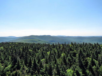
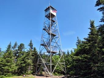 As we approached the tower clearing, we could hear voices. At 10:15 Am we arrived at the tower to find a group of men enjoying a laugh at the picnic table. We greeted each other as I leashed Sheila to the tower ad dropped my pack. They informed me that the tower was open and that brothers Kevin and Mike were there for the weekend. The day ha been getting warmer and the hike up the hill generated some sweat even though we had removed our jackets. As we climbed the tower, I noticed that I was cool as the breeze above the tree line hit me. Mike was in the tower so we went up to the cab. The view was good in all directions with some haze. I was a little disappointed that the sky was washed out without and puffy clouds. I took some pictures and we talked to Mike about the repairs they were planning to the tower and about towers in general. When it was time to leave, we all started down and I stopped to take some pictures from just below the cab. Once on the ground I untangled Sheila and we headed over to the cabin. Beth was interested me some to the history of the fire towers and the logistics of manning the towers and spotting fires. When we left the cabin, we headed down the trail on the Millbrook side. This part of the trail was even wetter than the other side with muddy pools in several different places. With leaves he the trees the views of Graham were limited. We were at the trail junction by 11:00 AM and we turned right to head back to the car. "wet" continued to be the theme of the day as there was a small stream running down the upper part of the trail. In several places I pointed out the stonework that helped to support the trail which was once a road from the Beaverkill Valley to the Millbrook-Arena area. Although it was wet the walk seemed to go quickly and we were soon passing the turn up the mountain. We continued at a good pace back to the parking area arriving at the car at 11:45 AM. We had covered 4.4 miles in 2.5 hours and Bath had her first 3500 peak completed.
![]()
![]()
![]()
![]()
![]() On Thursday, June 14th, I had planned to do a hike with a new hiking buddy, Beth. We met on a hike to Trout Pond sponsored by Morgan Outdoors and I had offered to show Beth some trails. She emailed me during the early part of the week and we had planned to hike on Thursday. The weather forecast had changed and showers did move through our area washing out our hike. I was disappointed as I could not hike on Friday since I was committed to being the middle school nurse on that day. When I arrived in school on Friday, I was informed that it was a half-day and that I could leave at about 12:15 PM. I called Beth and we made plans for me to pick her up at her second home in Livingston Manor as soon after 1;00 PM as I could. I got out of school a little late but made it to Beth's house around 1:15 PM. I wanted to hike Balsam Lake Mountain so we headed up the Beaverkill Road. I gave Beth a running commentary as we headed toward Lew Beach. The further I drove up the Beaverkill Road, the darker the clouds became. Since ether were some areas of sun mixed in with the clouds and no rain was falling I continued to drive to the trailhead. We arrived in the parking area just in time for the heavens to open up on us and pour down rain. We sat in the car hoping it would pass but the amount of cloud cover seemed to indicate a prolonged period of rain. We decided to head back toward town and stop at some other trailhead if the weather cooperated. By the time we got to Alder Creek Road the sun was shining so I turned right and headed toward Alder Lake. There were a couple of cars in the hen when we parked and we met the occupants near the remains of the Coykendall mansion as they were leaving. The grass on the "lawn" was not mowed which is a same since there are new picnic tables and the area is very popular. As I looked north and east I could see that the skies were starting to get cloudier but hoped the rain would hold off until we got to the lean-to.
On Thursday, June 14th, I had planned to do a hike with a new hiking buddy, Beth. We met on a hike to Trout Pond sponsored by Morgan Outdoors and I had offered to show Beth some trails. She emailed me during the early part of the week and we had planned to hike on Thursday. The weather forecast had changed and showers did move through our area washing out our hike. I was disappointed as I could not hike on Friday since I was committed to being the middle school nurse on that day. When I arrived in school on Friday, I was informed that it was a half-day and that I could leave at about 12:15 PM. I called Beth and we made plans for me to pick her up at her second home in Livingston Manor as soon after 1;00 PM as I could. I got out of school a little late but made it to Beth's house around 1:15 PM. I wanted to hike Balsam Lake Mountain so we headed up the Beaverkill Road. I gave Beth a running commentary as we headed toward Lew Beach. The further I drove up the Beaverkill Road, the darker the clouds became. Since ether were some areas of sun mixed in with the clouds and no rain was falling I continued to drive to the trailhead. We arrived in the parking area just in time for the heavens to open up on us and pour down rain. We sat in the car hoping it would pass but the amount of cloud cover seemed to indicate a prolonged period of rain. We decided to head back toward town and stop at some other trailhead if the weather cooperated. By the time we got to Alder Creek Road the sun was shining so I turned right and headed toward Alder Lake. There were a couple of cars in the hen when we parked and we met the occupants near the remains of the Coykendall mansion as they were leaving. The grass on the "lawn" was not mowed which is a same since there are new picnic tables and the area is very popular. As I looked north and east I could see that the skies were starting to get cloudier but hoped the rain would hold off until we got to the lean-to.
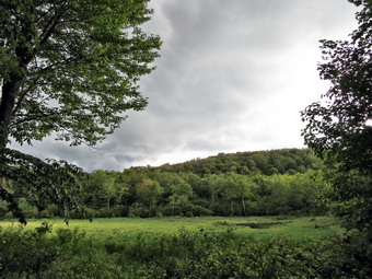
 We headed around the lake to the left passing the campsite both designated and impromptu. At the head of the lake we turned left on the trail that heads east, climbs Millbrook Ridge and meets the trail to Balsam Lake Mountain on the summit plateau. The trail was wet in places with some mud and running water but we worked our way around these places. It was still sunny and we could hear the brook beside the trail. The water was as high as I have seen it and there were many small cascades but none that were easy to photograph. Although the trail makes a pretty walk there isn't much to see so we kept up a good pace. From the turn onto the trail to the lean-to is about 1.5 miles. The trail never gets above a 12% grade and averages only 6% over the whole distance. In two spots the trail becomes almost level before climbing again. By 3.2 we had covered the 2.3 miles to the lean-to. I dropped my pack and took out the camera at which point I heard some rumblings of thunder. I knew we couldn't stay too long and would probably get wet on the way back. I took pictures of the beaver meadow and the ominous black sky overhead. I walked out to the "shore" of the meadow to take a few more pictures and then suggested to Beth that we head back to the car as quickly as possible. There were a few more rumbles of thunder but no rain drops until we got back to the "lawn". Beth went over to the dam and I took a few pictures of Alder Lake from the lawn. I also took a few from the dam as I founded interesting. As we headed back to the car we met two men with camping equipment headed out around the lake. In the parking lot there were a couple of cars. We were back at 4:30 PM having covered 4.6 miles in just over 2 hours with a few stops along the way. On our way out we noticed a large number of people and vehicles in the upper parking lot including at least one RV.
![]()
![]()
![]()
![]()
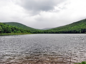
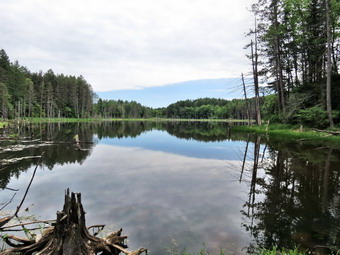
![]() On Wednesday, June 5th, I decided to head north to hike in Morgan Hill State Forest. So many people had given this area good reviews that I wanted to see it for myself. Fortunately the weather forecast was for partly sunny skies ahead of a major weather system that was heading for New York bringing rain for Thursday through Saturday! I had directions to Morgan Hill from the excellent Central New York Hikers website which also gave a detailed description of a "big loop" hike complete with mileage markers and highlights. It seemed like the trip from Livingston Manor would be about 130 miles and was projected to be about 2 hours and 15 minutes. I wanted to get an early start as I was unsure of the weather and knew that finding a trailhead for the first time can be aggravating! Sheila and I got up early and left Livingston Manor just after 7:00 AM. The trip was straightforward. I drove west and north on Route 17 to Binghamton and then north on I81 to exit 11. Route 13 north took us about 10 miles to Route 91 in Truxton where I turned left. After about 3.6 miles, I turned right on Shackham Road in Morgan Hill State Forest. This is where the trip got interesting. After about .5 miles, there was a pulloff at the side of the road where North Country Trail crossed. I knew this was not far enough up the road so I continued to drive until I saw a large parking area on the right and a state forest sign on the left. I parked the car and got out to find...nothing! No trails, no signs, no kiosk, nothing! I decided to drive a little farther up the road and within .5 miles found another pulloff on the right and signs for the North Country Trail. The North Country National Scenic Trail stretches approximately 4,600 miles from Crown Point on Lake Champlain in eastern New York to Lake Sakakawea State Park in central North Dakota in the United States. I parked the car at 9:15 AM and we were on the trail by 9:20 AM. We headed east on the NCT and it was only a short distance to the shores of Shackham Pond. The pond was pretty and was surrounded by very green trees. The water was completely still and the trees wand sky were reflected on the surface of the water. The only problem was that the skies was more overcast than cloudy and was not very interesting! I took some pictures before we headed back to the main trail. Within a few hundred feet we passed across the top of the dam that creates the pond. I again dropped my pack and took some more pictures from a different angle.
On Wednesday, June 5th, I decided to head north to hike in Morgan Hill State Forest. So many people had given this area good reviews that I wanted to see it for myself. Fortunately the weather forecast was for partly sunny skies ahead of a major weather system that was heading for New York bringing rain for Thursday through Saturday! I had directions to Morgan Hill from the excellent Central New York Hikers website which also gave a detailed description of a "big loop" hike complete with mileage markers and highlights. It seemed like the trip from Livingston Manor would be about 130 miles and was projected to be about 2 hours and 15 minutes. I wanted to get an early start as I was unsure of the weather and knew that finding a trailhead for the first time can be aggravating! Sheila and I got up early and left Livingston Manor just after 7:00 AM. The trip was straightforward. I drove west and north on Route 17 to Binghamton and then north on I81 to exit 11. Route 13 north took us about 10 miles to Route 91 in Truxton where I turned left. After about 3.6 miles, I turned right on Shackham Road in Morgan Hill State Forest. This is where the trip got interesting. After about .5 miles, there was a pulloff at the side of the road where North Country Trail crossed. I knew this was not far enough up the road so I continued to drive until I saw a large parking area on the right and a state forest sign on the left. I parked the car and got out to find...nothing! No trails, no signs, no kiosk, nothing! I decided to drive a little farther up the road and within .5 miles found another pulloff on the right and signs for the North Country Trail. The North Country National Scenic Trail stretches approximately 4,600 miles from Crown Point on Lake Champlain in eastern New York to Lake Sakakawea State Park in central North Dakota in the United States. I parked the car at 9:15 AM and we were on the trail by 9:20 AM. We headed east on the NCT and it was only a short distance to the shores of Shackham Pond. The pond was pretty and was surrounded by very green trees. The water was completely still and the trees wand sky were reflected on the surface of the water. The only problem was that the skies was more overcast than cloudy and was not very interesting! I took some pictures before we headed back to the main trail. Within a few hundred feet we passed across the top of the dam that creates the pond. I again dropped my pack and took some more pictures from a different angle.
 We resumed our hike heading north through mostly hardwood forest. At about .7 miles we crossed a well-maintained dirt road and entered an evergreen forest. I stopped at the trail register and signed in before continuing on the trail. The trail paralleled a small stream for some time and the trail continued to be wet and muddy in places. In this area the trail was almost flat with only a few bumps. We passed by several woods roads and at 1.9 miles the trail again crossed a road before entering the woods again. At this point we turned right on the dirt road which became Morgan Hill Road. I was not thrilled with walking on the road but the first part of it seemed pretty secluded and was almost like walking a woods road. After a slight uphill walk of about .3 miles at 2.2 miles into the hike there was a gate across the road which was locked to permit only "seasonal access". We continued straight ahead and I noticed that the road surface didn't change very much and I still had that "isolated" feeling. The day was warm and I was glad I had removed my light windbreaker. From the hike description I knew that the hike on the road would be pretty long so I settled in and started to think about the beauty around me. At 4.2 miles Eaton Hill Road came in from the left and I knew it would be only a half mile or so until the trail would appear on the right. I was not really paying attention when I checked the GPS and found we were already at 4.8 miles. I didn't see the trail and wasn't sure whether to walk back along the road or continue on. I decided to continue and the NCT crossed within a few hundred feet. We turned right into the forest and headed almost due east along a tributary of Shackham brook. We navigated a VERY muddy section of trail on our way to a beautiful ravine. At 5.2 miles we walked down the trail into the ravine. The trail crossed the brook here but I could see a small waterfall just upstream. We headed in that direction. I dropped my pack and got out the camera to take some pictures of the waterfall and the ravine. The sun shining through the trees made photography difficult and I was left wishing for less sun and more water in the stream. We walked back to where the trail crossed the stream and negotiated the steep bank.
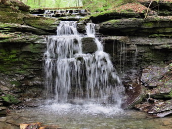
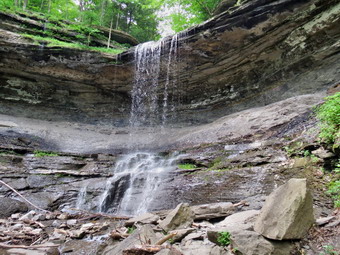 The trail almost immediately met a woods road and followed it for some distance until some recent and large blowdown made us detour briefly into the woods. Back on the main trail we started to walk parallel to the brook and I noticed several small waterfalls. At one point I saw a larger cascade and walked to the edge of the high bank. I took some pictures through the trees and then decided to try to make my way down to the streambed. After several attempts to find a route down the almost vertical bank I decided to give up. We continued to walk on parallel to the brook until 6.1 miles where there was another nice waterfall right off the trail. Although it wasn't that high the falls had three different steps and the light was better at this location. I stopped and took a few pictures before continuing on the trail toward Shackham Road. A nice footbridge crossed the stream and as I looked down I saw that the streambed was solid rock. Shackham Brook in this area flows for at least several hundred feet over solid bedrock. I took a few pictures and then tried to find a way around the very muddy patch on the other side of the trail. It was about 12:10 PM when we crossed Shackham Road about 6.6 miles into the hike the car was only about 1.5 miles up the road but I thought that the best part of the hike would be on the western side of the loop. After crossing the road the trail began to climb through hardwood forest almost immediately. Over the next .6 miles the trail climbed about 450 feet which was one of the steepest parts of the trail up to that point. At the top of the climb the trail leveled a bit as it ran along the shoulder of a hill on our right. After a short walk on relatively flat ground, we lost all of the elevation we gained on a descent to Tinker Falls. There was one major switchback on the descent and the trail at the bottom was not well marked. I stopped before crossing the stream above the falls to take some pictures of the unusual rock formation that had been cut by the stream. We crossed the stream and walked along the edge of the gorge. I could see the falls below but getting a good enough view for some pictures proved difficult. I could see people below but could not find a safe path down to the base of the falls! I also could not seem to find the blue blazes for the NCT so we walked along the the of the gorge before I decided that we were on the wrong path. As we turned around to hike back to the falls, I saw the people from below working their way up to the path we were on. When I spoke to them, they told me that the easiest way to get to the base of the falls was to park on Route 91 and walk the short "nature trail" to the falls. I thought I might try that after completing the loop.
 After some searching I found the NCT blazes. The trail comes down some steps on the east side, crosses the stream, goes a little more that 100 feet and then hooks back almost 180 degrees to climb the hill on the other side. We headed up the trail with our next stop being the hand gliding spot on the west side of Jones Hill. Over the next mile from the top of the falls we ascended about 430 feet. The trail was never steep but the ascent was continuous. We crossed at dirt road at some point and the trail turned onto it at another. Eventually the trail dipped to the right into the woods crossed the road one more time and eventually led us to the viewpoint on Jones Hill. It was about 1:40 PM and we were 9.6 miles into the hike. As the hike progressed my mileage and that on my hike description began to disagree with my GPS constantly reading longer. The view from Jones Hill was spectacular. There was a verdant valley below with a few hills and mountain in the distance. We were in the Labrador Unique Area and Labrador Pond was visible below. I took a lot of pictures of this pretty scene. I regretted that the sky was a little "flat" and some haze was hanging around. I estimated we still had about 3 miles to hike so we picked up and continued our walk. After a short distance, the trail turned right and we walked across the top of Jones Hill and entered private property. The next 1.2 miles saw the trail roll a little with no major ascents or descent until we walked down to Spruce Pond at around 11 miles. The skies continued to be overcast but the pond was beautiful. I knew that there must be a road of some kind to the pond as there were people fishing on the other side. I took some pictures and then continued to the NCT kiosk at the outlet end of the pond. I took a few pictures from the kiosk and then went back to the trail.
 The last 1.7 miles was mostly downhill with one little bump near the end. The first part of the trail parallel a stream and was a little wet and muddy. Leading up the bump there were several places where it looked as if water had poured across and down the trail during the last rain but most of these were just damp. The very last few feet of the trail were a muddy quagmire which Sheila and I avoid by cutting directly from the trail across the ditch and down to the road. We had covered 12.8 miles in just under six hours with a total elevation gain of 2580 feet. I turned around on Shackham Road and drove back down to Route 91. Instead of heading back home, I turned right and drove 1.2 miles north to the parking area for Tinker Falls. I parked on the left side of the road in the large parking area. I put Sheila on her leash and grabbed my camera to walk across the road. The trail to the falls was wide and "paved" with crushed stone. There were several benches along the stream. When we got to the end of the trail, we walked up the stone of the streambed to the base of the falls. I took a few pictures and then scrambled over some rocks to get even closer. The falls was pretty but I thought about returning after a good rainfall had swelled the creek. I decided not to go behind the falls as there seemed to be no point when the water was so low. We headed back to the car to complete the .6 mile round trip. I was glad to be driving home!
![]()
![]()
![]()
![]() On Tuesday, June 4th, I responded to a call for help from Jeff Senterman of the NYNJTC. Jeff needed volunteers to hike food and supplies into the trail crew working on the new stretch of the Long Path from Phoenicia to the trail from Woodland Valley to Wittenberg. Jeff wanted to meet at the Woodland Valley parking area at 9:00 AM so Sheila and I left the house at 7:00 AM just to make sure we weren't late. At 6:00 AM the thermometer read 42 degrees so I put on a long-sleeved shirt and a light windbreaker. As I headed passed Slide Mountain to Big Indian I realized that the trip was not going to be as long as I thought it would be! We arrived at the parking area at 8:15 AM! There were six or seven cars in the lot when I arrived. These belonged to the work crew. At about 8:45 a car rolled in and then another. The two occupants struck up a conversation so I decided to see if they were meeting Jeff. As it turned out, one person was just there for a day hike but the other, Cal, was waiting for Jeff. Cal is from Saugerties and has been a volunteer for the NYNJTC for many years. He has been a trail maintainer and builder and now supervises 40 miles of trail near North South Lake. As I found out later, Cal's other passion is skiing and ski instructing. Jeff arrived at about 9:00 AM and we divided the food between us. I emptied my pack almost completely and then stuffed it with food. I am not accustomed to carrying loads, in fact, I always try to minimized what I carry. As we hiked, I found out that I could easily have loaded 10 more pounds into the pack. We started up the trail to Wittenberg, taking as we went, and soon arrived at the trail register. Jeff signed in and told Cal and I to go on ahead which we did. Then two of us kept up a pretty fast pace as we walked and talked. This part of the trail to Wittenberg has never thrilled me and is always longer than I remember so having company made it go much faster. The trail climbs some at first but then changes to short ascent and descent making it roll some as it makes its way toward Wittenberg. The trail was wet and muddy in places but we could easily work our way around these. Sheila was enjoying the trip immensely especially the wet spots!
On Tuesday, June 4th, I responded to a call for help from Jeff Senterman of the NYNJTC. Jeff needed volunteers to hike food and supplies into the trail crew working on the new stretch of the Long Path from Phoenicia to the trail from Woodland Valley to Wittenberg. Jeff wanted to meet at the Woodland Valley parking area at 9:00 AM so Sheila and I left the house at 7:00 AM just to make sure we weren't late. At 6:00 AM the thermometer read 42 degrees so I put on a long-sleeved shirt and a light windbreaker. As I headed passed Slide Mountain to Big Indian I realized that the trip was not going to be as long as I thought it would be! We arrived at the parking area at 8:15 AM! There were six or seven cars in the lot when I arrived. These belonged to the work crew. At about 8:45 a car rolled in and then another. The two occupants struck up a conversation so I decided to see if they were meeting Jeff. As it turned out, one person was just there for a day hike but the other, Cal, was waiting for Jeff. Cal is from Saugerties and has been a volunteer for the NYNJTC for many years. He has been a trail maintainer and builder and now supervises 40 miles of trail near North South Lake. As I found out later, Cal's other passion is skiing and ski instructing. Jeff arrived at about 9:00 AM and we divided the food between us. I emptied my pack almost completely and then stuffed it with food. I am not accustomed to carrying loads, in fact, I always try to minimized what I carry. As we hiked, I found out that I could easily have loaded 10 more pounds into the pack. We started up the trail to Wittenberg, taking as we went, and soon arrived at the trail register. Jeff signed in and told Cal and I to go on ahead which we did. Then two of us kept up a pretty fast pace as we walked and talked. This part of the trail to Wittenberg has never thrilled me and is always longer than I remember so having company made it go much faster. The trail climbs some at first but then changes to short ascent and descent making it roll some as it makes its way toward Wittenberg. The trail was wet and muddy in places but we could easily work our way around these. Sheila was enjoying the trip immensely especially the wet spots!
When we got to the trail junction to the Terrace Mountain lean-to, Cal consulted the directions Jeff had provided. We were to turn right and hike until we found a large log across the trail. At this point we would turn left into the woods and look for the flagging that marked the route the new trail would take. I immediately realized why I could not find this trail in the fall when Cindy and I hiked to the Terrace Mountain lean-to. The original plan had been to end near the lean-to but the newest plan did not have the trail going anywhere near the lean-to. After a short walk up the trail. we found the log and looked into the woods to find the flagging. It was pretty easy to spot and after a slight miscue we found a continuous line of orange streamers marking the way. The remaining part of our journey was a bushwhack but the markers made an easy to follow path. In addition, the path had been traveled many times and was pretty easy to follow. The route followed the shoulder of a hill on our right with a steeper dropoff on the left. Although there were some ups and downs we gained under 300 feet. At one point the ribbons changed from orange to pink but one look at the directions showed that the point designated wetlands. At about 3.5 miles the streamers split with orange to the left and pink to the right. The directions said go to the right to camp and I inspected the ribbons to find "camp" written on several. Within less than .1 miles we were at the base camp for the trail crew. No one was home at this point so Cal and I took off our packs to plan our next move. Several bags were hung between trees and we assumed these contained our food. Our plan was to leave Cal at the camp with all the food while I hiked back to find out where Jeff was. Cal had planned to stay and help build the trail while I was headed back to the parking area. As soon as I had unloaded my pack, Jeff appeared and soon after that the camp chef. We lowered the heavy bags from the trees and put our supplies in the bags. Lifting the bags back up to an acceptable level moved to be a three man job! Jeff and I didn't stick around too long before hiking back to the cars. The trip was more downhill on the way back. Jeff and I kept a steady pace and the trip went quickly. Just before the register the day hiker from earlier caught up to us. He said the views from Wittenberg had been great and I was just a little envious! I hiked 7.1 miles in just under 5 hours with 2150 feet of ascent. It felt good to help with a Trail Conference project if only in a small way!
![]()
![]()
![]()
![]()
![]() On Tuesday, May 28th I wanted to hike 3500 foot peak but needed to do one close to home. I knew Graham was open for May on my grid and I decided that it was a good choice. I seldom hike Graham alone since including Balsam Lake is so easy but on this day I needed to be quick for two reasons. I had track practice at 3:00 PM and rain was forecast for around 1:00 PM. I wondered if there would be any snow left at the summit from the storms over the weekend! The morning was hazy and the temperature was increasing rapidly as I pulled out of the driveway with Sheila. I made good progress until I got behind two slow moving vehicles just after Turnwood. Coincidentally, this is where the road begins to deteriorate. Both vehicles turned off before the Quill Gordon Lodge and right after that point the road had one lane sections and was very eroded. I came upon one spot where the road was narrowed and the Ulster County DPW was working to fill in some holes. The room left for me to pass was just wide enough. We arrived at the parking area at just after 9:00 AM and got hiking almost immediately. The skies were partly sunny but he clouds were getting darker and the wind was picking up even as we were leaving the car. The first part of the trail to the cutoff up Balsam lake Mountain went quickly. There was some blowdown which someone had attacked with an axe but the trail was drier than I thought it might be. We hit the cutoff at 9:29 AM taking only 20 minutes to cover the .9 mile distance. We continued straight ahead. The trail had few obstructions but the rocky section seemed to be particularly nasty. Some of these sections were wet which made the rocks slippery. It didn't take us long to get to the other cutoff up balsam Lake and again we continued straight on the main trail. Before we got to the path to Graham there were a few more trees across the path that had to be negotiated. We were at the path to Graham by 9:55 AM or about 45 minutes for the two mile hike. He turned right onto the path to Graham. The path had little or now brush obstructing it and seemed "cleaner" than it had been on past hikes.
On Tuesday, May 28th I wanted to hike 3500 foot peak but needed to do one close to home. I knew Graham was open for May on my grid and I decided that it was a good choice. I seldom hike Graham alone since including Balsam Lake is so easy but on this day I needed to be quick for two reasons. I had track practice at 3:00 PM and rain was forecast for around 1:00 PM. I wondered if there would be any snow left at the summit from the storms over the weekend! The morning was hazy and the temperature was increasing rapidly as I pulled out of the driveway with Sheila. I made good progress until I got behind two slow moving vehicles just after Turnwood. Coincidentally, this is where the road begins to deteriorate. Both vehicles turned off before the Quill Gordon Lodge and right after that point the road had one lane sections and was very eroded. I came upon one spot where the road was narrowed and the Ulster County DPW was working to fill in some holes. The room left for me to pass was just wide enough. We arrived at the parking area at just after 9:00 AM and got hiking almost immediately. The skies were partly sunny but he clouds were getting darker and the wind was picking up even as we were leaving the car. The first part of the trail to the cutoff up Balsam lake Mountain went quickly. There was some blowdown which someone had attacked with an axe but the trail was drier than I thought it might be. We hit the cutoff at 9:29 AM taking only 20 minutes to cover the .9 mile distance. We continued straight ahead. The trail had few obstructions but the rocky section seemed to be particularly nasty. Some of these sections were wet which made the rocks slippery. It didn't take us long to get to the other cutoff up balsam Lake and again we continued straight on the main trail. Before we got to the path to Graham there were a few more trees across the path that had to be negotiated. We were at the path to Graham by 9:55 AM or about 45 minutes for the two mile hike. He turned right onto the path to Graham. The path had little or now brush obstructing it and seemed "cleaner" than it had been on past hikes.
 From the beginning of the path there is an initial drop of about 150 feet over .4 miles and then the route flattens out for the next .75 miles. The trail was wet in some spots but these places could be avoided. Sheila did not choose to avoid many of these spots! At about 3.2 mile the climb up Graham began. As we were hiking up the mountain the skies continued to darken and the wind was blowing harder. Over the last .8 miles we gained 600 feet and there were some very wet and muddy areas. On the way up we bypassed the lookout on the north side of the trail. At 10:45 AM we were at the summit having covered almost 4 miles in an hour and 35 minutes. I took some pictures of the ruins at the top and the limited views from the summit. We then headed over to the lookout toward the south and I took some shots there. Being there reminded me of how much I want to bushwhack over to Doubletop! We walked back to where I had dropped my pack and got ready for the return trip. On the way down we stopped at the lookout and I took a few pictures before going back to the main trail. I had hoped to keep an even faster pace on the way back but the loose rocks slowed us some on the descent. Once we hit the main trail we turned left to get back to the car. We kept a fast pace but once again some slippery rocks slowed my progress. Rain started somewhere on this part of the trail and continued until we arrived back at the car at 12:43 PM. We had covered 7.9 miles in 3 hours and 34 minutes. If the rain had not started, I would probably have regretted not hiking Balsam Lake Mountain also!
On Saturday, May 26th, Morgan Outdoor was sponsoring a hike to Trout Pond at 1:30 PM even though it had rained the day before and most of Saturday morning. The temperature was in the 40's and there had been snow on some of the higher peaks! In fact, the weather had been poor for the entire week with showers, rain and thunderstorms plus cold temperatures. Jeff Senterman from the NYNJTC was in town and I did want to go on the hike. In the morning I worked at the church's chicken barbecue and took Sheila on a hike over Round Top. Around 1:00 PM I headed down to Morgan Outdoor and found there were only two people plus Jeff and Lisa to hike. At about 1:30 PM we got in the cars and headed to Trout Pond. I suggested that we park on Morton Hill Road which we did. Lisa informed me that the small parking area was on private property which I had not known. Rather than pull into the lot we parked alongside the road. As soon as we started to hike down the road we ran into people camped illegally by the small stream. Some of the tents seemed to be almost straddling the stream in a place which is not a designated campsite. We could see that the campers were really "roughing it" as they had only a small generator running! Further down the road, no one was camped at the legal campsite on the left. The upper falls were running nicely and I explained some of the local history to Beth. Beth is a second homeowner in the area and really would like to hike more in the area. At the lower parking area we turned right and walked down the trail and across the bridge. I pointed out the huge patch of invasive Japanese knotweed as we headed over to the falls. We did not walk down into the stream bed as the bank was very slippery. We did walk up the small path which overlooks the falls. I had forgotten what a nice view this is even if it is hard to photograph. Back on the main trail we stayed right at the fork and headed up to Trout Pond. The campsite on the trail to Mud Pond was full and the people seemed to be having a very good time. We met several hikers coming back from Trout Pond as we started up the trail.
Since we were walking and talking the hike went quickly and we were soon at the outlet to the pond. We stopped but the day was pretty overcast and the clouds were getting darker. The walk to the lean-tos went quickly and I was not surprised that they were empty. Since you can't drive to the them, some people would rather camp illegally! At this point Lisa, Jeff and the other hiker decided to return by turning around and retracing their steps. Beth expressed a desire to continue around the loop and I was more than happy to oblige. We said "goodbye" to the others and then crossed the bridge to head up the trail. This area was a little wet but the trail soon dried as we gained some elevation. We set a pretty quick pace over the rolling terrain. When we arrived at the "Grove of Many Small Trees", I knew we would soon be at the snowmobile trail that runs by Mud Pond. At this trail we turned left and walked won the hill toward the trail register to complete the loop. Just before the register we passed the campsite which seemed like a tent city. It wasn't long before we were climbing back up Russell Brook Road to the car. I enjoyed hiking with Beth very much and I hope to be able to introduce her to some more hikes in the future.
On Saturday, May 26th, Morgan Outdoor was sponsoring a hike to Trout Pond at 1:30 PM even though it had rained the day before and most of Saturday morning. The temperature was in the 40's and there had been snow on some of the higher peaks! In fact, the weather had been poor for the entire week with showers, rain and thunderstorms plus cold temperatures. Jeff Senterman from the NYNJTC was in town and I did want to go on the hike. I got up at 6:00 AM to help start our church's chicken barbecue. By 10:00 AM the chicken was cooking and there were enough hands to man the pits. After stopping the church to see if any help was needed, I decided to get Sheila out as she had been cooped up all week. We walked across the street to the hill behind the church and up the road to the trail into the woods. As soon as I let Sheila off the leash she was dashing back and forth through the woods! I decided to do the loop around Round Top in a counterclockwise direction. We headed up the paths and past the quarry. We descended the other side and then climbed the next hill which is actually higher than Round Top. As we walked down the other side I regretted not bringing my poles as the dirt was loose with a covering of wet leaves. At the bottom of that hill we began to circle around to the left. There was some mud and the grass was wet so my shoes slowly began to soak through! At one point I was deep in my own thoughts and looked up to see Sheila staring at a deer about 20 feet away. She made no attempt to move closer nor did she bark. Only as the deer bounded off did she make a move to follow it which I quickly discouraged. We continued the familiar route around the hills passing another quarry and walking down to the path that parallels the Quickway. Soon we were headed back up the hill to complete the loop. We walked by the lookout over town and then back down the hill toward the cemetery. Up on the hill another I saw another deer which saw us and snorted loudly. Sheila looked an then increased her pace along our path. It was a short hike but I was glad to be out and I was looking forward to the afternoon hike.
![]() On Saturday, May 18th, Cindy and I were in Dover, New Hampshire to attend a wedding. When we arrived on Friday, we visited the Garrison Hill Tower and got some nice views of Dover. Since we couldn't get to the White Mountains, hike and get back in time for the wedding, I searched for places to visit. Dover is a little inland but just to the south is Portsmouth, New Hampshire which has had a naval yard since very early in colonial times. This naval yard and the access the river provided needed to be protected so seven forts were built at various times to provide that protection. These forts were fortified over the years especially in times of conflict with the last such fortification being as the Second World War. None of the forts are currently active. All have some ruins to visit with some being maintained better than others. One has been made into a nice state park. I asked Cindy if she would like to go and she said "Yes". We got up pretty early, ate some breakfast and headed south for the 25 minute drive to Portsmouth. My plan was to visit Fort Constitution, Fort Stark, Pulpit Rock Tower, Fort Dearborn and Fort McClary. Fort Dearborn is now Odiorne Point State Park and Fort McClary is in Kittery, Maine which is only a short drive to the northeast.
On Saturday, May 18th, Cindy and I were in Dover, New Hampshire to attend a wedding. When we arrived on Friday, we visited the Garrison Hill Tower and got some nice views of Dover. Since we couldn't get to the White Mountains, hike and get back in time for the wedding, I searched for places to visit. Dover is a little inland but just to the south is Portsmouth, New Hampshire which has had a naval yard since very early in colonial times. This naval yard and the access the river provided needed to be protected so seven forts were built at various times to provide that protection. These forts were fortified over the years especially in times of conflict with the last such fortification being as the Second World War. None of the forts are currently active. All have some ruins to visit with some being maintained better than others. One has been made into a nice state park. I asked Cindy if she would like to go and she said "Yes". We got up pretty early, ate some breakfast and headed south for the 25 minute drive to Portsmouth. My plan was to visit Fort Constitution, Fort Stark, Pulpit Rock Tower, Fort Dearborn and Fort McClary. Fort Dearborn is now Odiorne Point State Park and Fort McClary is in Kittery, Maine which is only a short drive to the northeast.
 We got an early start and arrived at Fort Constitution at about 8:30 AM. We parked in the small lot and were immediately confronted with Battery Farnsworth which was an addition from World War II and was off limits. We walked through the gate of the Coast Guard station and made sure to walk on the blue line through the parking lot to the gate of the fort. The fort is mostly red brick near the entrance from the construction in the early 1800's. I immediately began to take pictures. A large portcullis was retracted but would have blocked entry form the land side. Inside the gate was a sentry post. Once inside we made roughly clockwise tour of the fort. We walked up to the gun positions on the walls where all that remained was the emplacements without guns. On the side facing the sea there were thick concrete walls from later additions to the fort. These walls had firing slits with bars. We walked down to the water and over some of the rocks exposed by the low tide. Out in the bay we could see the Isles of Shoals with one building and a lighthouse. I could also see a building across the bay on the Maine side. I didn't know it at the time but this was Fort McClary! I took picture of the Isles of Shoals and of the lighthouse next to the fort. We continued to walk around the walls of the fort. We inspected the north and south sally ports another walked up on the walls to a cement blockhouse. My last stop was at only building left standing in the interior of the fort. It was of vaulted brick construction and served as a powder magazine. We left Fort Constitution and drove around the peninsula we were on to Fort Stark.
 We arrived at Fort Stark at just after 9:00 AM to find a group of people working in the area. One of the ladies present told us that this was a work party from the Friends of Fort Stark, a group of people who have a passionate interest in preserving and restoring Fort Stark. They have cleaned up the area cutting away the brush that had overgrown the area. They have also converted an existing machine shop into a museum which houses memorabilia from Fort Stark and the other forts in the area. The building houses a signal gun and some of the machines that were used in the shop, communications equipment and various documents. One member handed us a map of the fort that also had a self-guided walking tour. Most of what remains of Fort Stark dates to World War II and is constructed of concrete. The most noticeable structure above ground is the Harbor Entrance Command Post which looks like the superstructure of a ship. We walked up through Battery Hayes and then in front of the NECP and own to the water. It was interesting to again see the Isles of Shoals and the harbor from a different angle. Fort Constitution was also clearly visible. After coming back up from the water we walked to Battery Hunter, the biggest battery at the fort, which housed two 12 inch rifles that could hurl shells 20 miles! We walked around the battery and down to the water again. There was a breakwater built in the late 1800's jutting out into the water. On the shore was an oil storage ho the and the remains of the pier. Across a narrow body of water we could see Odiorne Point which was the site of Fort Dearborn. We walked up onto Battery Lytle which resembled Battery Hayes on the other side of the fort. To get back to the parking area we walked along the base of Battery Hunter. I was impressed by the two foot thick cement walls that protected the battery. When the fort was fully operational there were many other buildings that have since been torn down. We got in the car and headed for Odiorne Point State Park which was the site of Fort Dearborn.
 It took about 20 minutes to drive to Odiorne Point State Park and we arrived in the parking area just before 10:00 AM. The drive along the highway was interesting as it follows the seacoast and there are many nice views and beautiful homes. When we parked there were only a few cars in the lot and we walked northeast out to Odiorne Point. Fort Dearborn is the name given to all the fortifications and gun emplacements of Odiorne Point. On the point itself were the remains of four gun mounts that in 1942 sported 155 mm guns. Only the mount and the tracks remain with a sign to mark there location. Across the water but not too far away we could see the Pulpit Rock Tower which served to control and coordinate the fire from the fort. These towers once dotted the coast but most have been removed. We walked along the seashore in a counterclockwise direction enjoying the beautiful weather and the views out over the ocean. Soon we arrived at the battery commanders station that marks the position of Battery 204 which was constructed during World War II. The battery housed new 6 inch shielded guns but the battery commanders station was built directly on top of the magazine which was later deemed "unsafe"! From the battery we walked to the Seacoast Science Center. We weren't too interested in the museum but a friendly employee gave me some information about the hiking trails and a map. We left the center and walked around the back to find the hiking trail that led southwest toward Battery Seamen. The walk along the shore was enjoyable. We stopped at the Founder's Memorial dedicated to the first settlers who landed in 1623. The trail had several branches so we headed for the southwest end of Battery Seamen. The size of the battery was truly impressive as it house a sixteen inch gun capable of throwing shells 26 miles out to sea. It was disappointing to see all the graffiti defacing these historical landmarks! We walked up to the top of Battery Seamen to the battery commanders station and then down the path which led to Frost Point. As we descended we could see Wentworh-by-the-Sea which is the only large resort hotel left on the New Hampshire Coast. From Frost Point we could see Fort Stark just across the water. We walked southwest and to the south side of Battery Seamen to see the other gun emplacement and then headed back along the trail to the parking area. From Fort Dearborn we drove the short distance to the Pulpit Rock Tower and parked. The walk to the tower was only a few hundred feet and we took a few pictures before heading out to Kittery Point, Maine to visit Fort McClary.
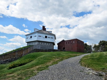 The drive to Maine was a little harder than I expected since I did not have an exact address for the GPS. It turned out that one route was about as good as another. Once we headed for the seashore it wasn't too hard to find the coastal highway and the Fort McClary site was clearly marked. We parked by an impressive stone bastion just before noon. The site required a $3 entry fee which we gladly paid. Like the other sites a fortification has been at the Fort McClary site for over 275 years. Fort McClary was never updated after the Civil War and so does not have any concrete structures. It has an "older" feel than the other places we visited. The blockhouse which dominates the site was built in the 1840's and is in remarkable condition and open to the public. The foundation is fieldstone while the first story is cut granite and the top story is constructed of logs. I descended to the bottom level and found the granite with carefully cut firing loops. Above this level was a level with a cannon mounted toward the sea. The top story gave some impressive views of the water and was used as officers quarters. From the blockhouse I walked down into the bastion which was constructed of cut stone and also had firing slots and a small magazine. Construction was begun during the Civil Ware but never completed. Between the bastion and the blockhouse there were several buildings still standing. A riflemen's house and magazine for powder storage were constructed in 1808 from red brick. The outlines of another house and barracks lie west of the blockhouse. In front of the blockhouse is a granite wall and some earthen works with an 8 inch Dahlgren cannon on display. I took some pictures and then we walked down to the final wall before the sea. The wall was part of the 1860's construction which was never completed. The views from the wall included the Isles of Shoals and Fort Constitution. A caponier extends out from the walls and we walked down into it although the floor was very damp. The caponier has rifle slits to allow raking fire on the exposed walls. We walked back passed the blockhouse and to our car. Cindy's price for visiting all the forts was some kind of lobster lunch. We stopped at Bob's Clam Hut in Kittery where Cindy had a lobster salad and I ordered butterfly shrimp. The unassuming place was packed and the prices were those of a four star restaurant but the food was delicious.
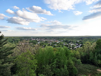
![]() On Friday, May 17th, Cindy and I drove to Dover, New Hampshire to attend a wedding on Saturday. When I heard "New Hampshire", I thought "White Mountains". Unfortunately, Dover is on the coast and it is at least a two and a half hour drive to the Whites. When we got into town, we decided to go to dinner and hit an interesting spot in Dover called Dos Amigos Burritos. After eating on the drive back to the motel, we stopped at a city park where there was an observation tower that was constructed in 1993 to replace a tower removed in 1990. There was really no hike involved since we parked only a few hundred feet from the tower. The Garrison Hill Tower is 76 feet tall and constructed of iron and steel with wooden steps. There is an observation platform at the top which has views of Dover. On a clear day the White Mountains can be seen to the northwest with the Isles of Shoals visible to the southeast.
On Friday, May 17th, Cindy and I drove to Dover, New Hampshire to attend a wedding on Saturday. When I heard "New Hampshire", I thought "White Mountains". Unfortunately, Dover is on the coast and it is at least a two and a half hour drive to the Whites. When we got into town, we decided to go to dinner and hit an interesting spot in Dover called Dos Amigos Burritos. After eating on the drive back to the motel, we stopped at a city park where there was an observation tower that was constructed in 1993 to replace a tower removed in 1990. There was really no hike involved since we parked only a few hundred feet from the tower. The Garrison Hill Tower is 76 feet tall and constructed of iron and steel with wooden steps. There is an observation platform at the top which has views of Dover. On a clear day the White Mountains can be seen to the northwest with the Isles of Shoals visible to the southeast.
On Thursday, May 16th, I decided to take our two-year-old grandson Bryce on another hike on Round Top behind our church in Livingston Manor. The last time we hiked we did not follow some of the paths. In an effort to shorten the walk, I inadvertently made it more difficult. My wife went with us so I also took Sheila our year old yellow lab mix. We walked down the driveway and looked both ways as we crossed the street. The hill behind the church is pretty steep and I know this since Bryce remarked about the incline. At the top of the hill we turned left into the woods on a path or woods road that led us to a lookout over downtown Livingston Manor. Bryce remembered just where we were supposed to turn and let us know. Along the way he picked up an interesting rock and I showed him how to make "rock music". This might have been a mistake since he then wanted to pick up EVERY rock he found and bang it on another rock. Where the trail split we headed to the right his time and took a gradual path up the hill before taking a left for a steeper ascent. At the top we had to bushwhack a little and I introduced Bryce to the term. We ended up at the lookout over town. He seemed interested in looking at the post office and school, which he visits regularly, from a different angle. We then headed back down the trail to the point where we had turned right earlier in the hike. From there we walked back down the steep hill to the church. We walked back across the street to complete our 40 minute adventure with Bryce walking the whole way. I am sure there will be many more and I look forward to them all! Later that night I got a text from my daughter-in-law. When asked what we did during the day Bryce responded "I hiked with Grampy. It was steep! Really, really steep!"
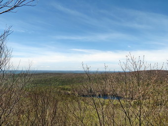
![]()
![]()
![]()
![]()
![]() On Tuesday, May 14th, I asked Cindy if she would like to hike and she said "Yes". I decided to take her to the Hodge Pond Lookout where Lisa and I had been in February. The morning was a little hazy and I had some chores to do so we didn't arrive at the Frick Pond parking area until 10:30 AM. I had decided on the most direct approach so we headed across the road and up the Flynn Trail. The skies were blue with a few white clouds and some sun although the temperature seemed coo. The Flynn Trail is uphill all the way for the first 1.7 miles to the Big Rock Junction but we set a fast pace. We continued through the junction to the point where the Flynn Trail heads downhill to Hodge Pond. At this point we turn to the right on a woods road and walked along the "high road" to the junction of some roads above the pond. At this junction a road turns left to go down to the pond. Just a little further on the road splits with the left fork passing by the old Beech Mountain Boy Scout Camp and ending up on Shin Creek Road in Lew Beach. We continued straight ahead to climb the road up the hill. The road was a little steeper than I remembered but we kept our pace. It was a lot easier hiking than in February on snowshoes! We passed by a spring house on the right and at 2.6 miles turned right onto a another woods road. This turn occurred where the main road turned sharply to the left. The trail we turned onto was more well defined than I remembered and the tracks of an ATV were faintly visible. After a slight incline, we walked to 2.9 miles over flat ground to the Hodge Pond Lookout. I dropped my pack and took some pictures of the pond below and the hills in the distance. Only a few leaves were beginning to come out on the trees but I could see how they would soon block the view.
On Tuesday, May 14th, I asked Cindy if she would like to hike and she said "Yes". I decided to take her to the Hodge Pond Lookout where Lisa and I had been in February. The morning was a little hazy and I had some chores to do so we didn't arrive at the Frick Pond parking area until 10:30 AM. I had decided on the most direct approach so we headed across the road and up the Flynn Trail. The skies were blue with a few white clouds and some sun although the temperature seemed coo. The Flynn Trail is uphill all the way for the first 1.7 miles to the Big Rock Junction but we set a fast pace. We continued through the junction to the point where the Flynn Trail heads downhill to Hodge Pond. At this point we turn to the right on a woods road and walked along the "high road" to the junction of some roads above the pond. At this junction a road turns left to go down to the pond. Just a little further on the road splits with the left fork passing by the old Beech Mountain Boy Scout Camp and ending up on Shin Creek Road in Lew Beach. We continued straight ahead to climb the road up the hill. The road was a little steeper than I remembered but we kept our pace. It was a lot easier hiking than in February on snowshoes! We passed by a spring house on the right and at 2.6 miles turned right onto a another woods road. This turn occurred where the main road turned sharply to the left. The trail we turned onto was more well defined than I remembered and the tracks of an ATV were faintly visible. After a slight incline, we walked to 2.9 miles over flat ground to the Hodge Pond Lookout. I dropped my pack and took some pictures of the pond below and the hills in the distance. Only a few leaves were beginning to come out on the trees but I could see how they would soon block the view.
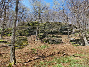 After taking pictures, I asked Cindy if she wanted to climb to the top of the hill behind us. She suggested we follow the woods road we had been on as it might head up to the top. We walked along the road and came to some steeper cliffs at the south end. At this point the road began to turn to the west and then north. I suspected that it would circle the hill and take us back to the "main" road we had used to hike up the hill from above the pond. We continued to walk and were treated to some nice cliff bands on our left. Very shortly we did intersect the road and turned left to walk back. I suggested we walk to the top of the hill as I suspected it might be interesting. I also thought that this might be the Sullivan County High Point which I had visited only twice. Just as we decided to walk to the top we found a woods road heading up to the top and took it. The road took us to the relatively flat summit plateau and then became overgrown and hard to follow. I decided to walk to the highest point I could find on the plateau while Cindy walked over to the western edge of the plateau to find a way down. Sheila and I found what I determined to be the highest point and then walked to the edge of the plateau to find Cindy. We walked down the steep bank to the trail and back out to the road. When the road turned sharply left, we stopped at a .limited viewpoint to take a few pictures. A brilliant splotch of blue in the trees caught my eye. I was sure this was an indigo bunting or some other colorful bird. I zoomed in with my camera to get a closer view of...a piece of blue plastic. We continued down the road and as we passed the spring house Sheila took a keen interest in something by the side of the road. She got closer and started to dig and then shied away. It took me a moment to realize she was reacting to...the water pulsing in the pipe from the spring. After all this excitement, we were ready to head back to the car. We simply retraced our route down the Flynn Trail after considering some other options. We were back at the car by 1:20 PM having covered 6.6 miles in 2 hours and 45 minutes with an elevation gain of over 1300 feet.
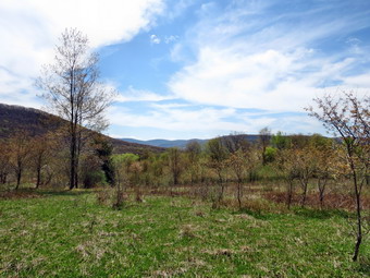
![]()
![]()
![]()
![]()
![]() On Friday, May 10th, I had several different plans for the day. The first plan was to drive north to Cortland County to hike Morgan Hill State Forest. I decided against this as the weather forecast was for thunderstorms and I wanted plenty of time to hike the 12 mile loop at this new location. I thought about Bearpen and Vly but rejected them as the timing of the thunderstorms was tricky. I finally decided to go to Big Pond and hike the TRAIL loop that I had missed on Tuesday when I hiked the ROAD loop with Lisa. I thought I would throw in Cabot Mountain if I felt like it when I got to that trail junction. When I woke up early, I found a heavy fog sitting over Livingston Manor so I was in no hurry to get going immediately. Sheila and I left the house before 9:00 AM and arrived at the parking area a little after 9:00 AM. There was one other car parked and I talked to the owner but it was not clear what he was going to do. The black flies were heavy again so I took a few moments to put on some repellant before crossing the road and heading up the trail. There was no reason to stroll leisurely as we had done that on Tuesday so Sheila and I set a fast pace to the top of TouchMeNot Mountain. The trails were a little damper than last time but not really wet. As I stepped on one wet rock and went to one knee I was reminded to pay attention so that my hike did not end early! by 9:42 AM we has hiked a little over a mile to the trail junction with the Little Pond Loop Trail. I again noticed that the mileage on the signs is VERY inaccurate as the sign stated it was .8 miles back to Big Pond! I decided to turn left and walk down to Little Pond the way we had on Tuesday. We did not stop to investigate any viewpoints as I already knew there were none. The descent on the other side of the mountain was even trickier than Tuesday as the leaves were now damp and more slippery than before. As we neared the campsites, both Sheila and I could hear a racket that reminded me of chainsaws. When we passed behind the bathhouses I could see some workers cutting a tree near the entrance. It was 10:20 Am when we stopped at the bridge over the outlet of the pond after hiking 2.25 miles. I took a few pictures as the sky had a different look. We continued around the pond on the far side and stopped at the boat launch. Sheila immediately took to the water and I got out the camera to take some shots of TouchMeNot Mountain. We stayed for a few minutes and then got back on the loop trail until we hit the junction with the TouchMeNot Trail where we turned left.
On Friday, May 10th, I had several different plans for the day. The first plan was to drive north to Cortland County to hike Morgan Hill State Forest. I decided against this as the weather forecast was for thunderstorms and I wanted plenty of time to hike the 12 mile loop at this new location. I thought about Bearpen and Vly but rejected them as the timing of the thunderstorms was tricky. I finally decided to go to Big Pond and hike the TRAIL loop that I had missed on Tuesday when I hiked the ROAD loop with Lisa. I thought I would throw in Cabot Mountain if I felt like it when I got to that trail junction. When I woke up early, I found a heavy fog sitting over Livingston Manor so I was in no hurry to get going immediately. Sheila and I left the house before 9:00 AM and arrived at the parking area a little after 9:00 AM. There was one other car parked and I talked to the owner but it was not clear what he was going to do. The black flies were heavy again so I took a few moments to put on some repellant before crossing the road and heading up the trail. There was no reason to stroll leisurely as we had done that on Tuesday so Sheila and I set a fast pace to the top of TouchMeNot Mountain. The trails were a little damper than last time but not really wet. As I stepped on one wet rock and went to one knee I was reminded to pay attention so that my hike did not end early! by 9:42 AM we has hiked a little over a mile to the trail junction with the Little Pond Loop Trail. I again noticed that the mileage on the signs is VERY inaccurate as the sign stated it was .8 miles back to Big Pond! I decided to turn left and walk down to Little Pond the way we had on Tuesday. We did not stop to investigate any viewpoints as I already knew there were none. The descent on the other side of the mountain was even trickier than Tuesday as the leaves were now damp and more slippery than before. As we neared the campsites, both Sheila and I could hear a racket that reminded me of chainsaws. When we passed behind the bathhouses I could see some workers cutting a tree near the entrance. It was 10:20 Am when we stopped at the bridge over the outlet of the pond after hiking 2.25 miles. I took a few pictures as the sky had a different look. We continued around the pond on the far side and stopped at the boat launch. Sheila immediately took to the water and I got out the camera to take some shots of TouchMeNot Mountain. We stayed for a few minutes and then got back on the loop trail until we hit the junction with the TouchMeNot Trail where we turned left.
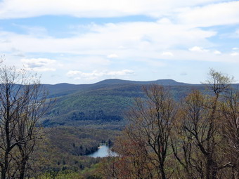 The trail to the clearing that overlooks the valley is usually very wet. The worst spot is near the beaver meadow not far from Little Pond. I looked out at the beaver meadow when we got there but it didn't have much to offer. The trail just after the meadow was almost dry as was most of the rest of the trail. We were soon on the old woods road that rises to the clearing where there is a pond and the foundation of an old house. I had hoped to find some tiger lilies blooming but it looked like I was too early as the plants had no flower stalks emerging. I stopped to take a few pictures from the lookout and the continued on to the trail junction to Cabot Mountain. The trail to Cabot is short but very steep and is always covered with nettles later in the year. We turned left and started up the trail and, as I had hoped, there were no nettles at all. The trail was rather dry and seemed steeper and longer than I remembered! From Little Pond to the top of the climb is a change of over 900 feet! The last .4 miles of the climb is the steepest averaging over 22% and gaining over 450 feet. When the trail leveled at the top, we walked on the flat trail to the rock ledge that makes a nice viewpoint down to Little Pond. Both Sheila and I got a drink. I took some pictures of Little Pond and the surrounding mountains before turning around to head back down the way we had come up. The trip back down was a little slower than I wanted but I was making sure I did not slip. Once we were back at the trail junction we continued on around for about .5 miles to the trail junction at the top of TouchMeNot Mountain. Along the way I noted several more trees across the trail. From the trail junction it was all downhill for about a mile to the parking area. I put Sheila in the car and went to the shore a Big Pond to take some pictures. We had walked 6.7 miles in 3 hours and 40 minutes with a total ascent of over 2200 feet!
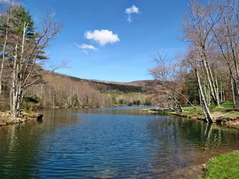
![]()
![]()
![]()
![]()
![]() On Tuesday, May 7th, I had wanted to hike since the rest of the week was forecast to be wet. The forecast for Tuesday was for sunny skies with clouds and a high temperature in the 70's. I had thought about Bramley Mountain but decided that might be pushing things with an away track meet ion the afternoon. I called Lisa and we decided to do the "loop" from Big Pond over TouchMeNot Mountain to Little Pond. I though we might even throw in Cabot Mountain. I was really looking forward to the view above Little Pond where an old foundation often has tiger lilies growing. I picked up Lisa at her home which is on the way to Big Pond. We parked at Big Pond and were ready to hike by 8:45 AM. It was already warm and the blackflies were out in force. We put on some insect repellant and walked across the road to start the hike. As we climbed from the road and continued through the woods the trails were very dry which is not typical of this area. There were few prickers and not nettles which also populate this area later in the season. There were several areas where trees blocked the trail. Some of these trees could be removed with an axe or bow saw while others will require some chainsaw work. The first mile of the trail seems steep at times but only gains about 800 feet. By 9:30 Am we were at the junction with the Little Pond Loop Trail and Lisa suggested we turn left and I agreed as I normally turn right. Lisa was looking for an overlook where we could take pictures of Little Pond but anything we found had no open views. The .4 miles across the ridge went quickly and then we were ready to descend the steeper side of the mountain to the campgrounds. Over the next .5 miles we dropped almost 600 feet averaging a 22% grade. Soon we were at the area behind the bathrooms at the state campgrounds and we walked over the outlet end of the pond.
On Tuesday, May 7th, I had wanted to hike since the rest of the week was forecast to be wet. The forecast for Tuesday was for sunny skies with clouds and a high temperature in the 70's. I had thought about Bramley Mountain but decided that might be pushing things with an away track meet ion the afternoon. I called Lisa and we decided to do the "loop" from Big Pond over TouchMeNot Mountain to Little Pond. I though we might even throw in Cabot Mountain. I was really looking forward to the view above Little Pond where an old foundation often has tiger lilies growing. I picked up Lisa at her home which is on the way to Big Pond. We parked at Big Pond and were ready to hike by 8:45 AM. It was already warm and the blackflies were out in force. We put on some insect repellant and walked across the road to start the hike. As we climbed from the road and continued through the woods the trails were very dry which is not typical of this area. There were few prickers and not nettles which also populate this area later in the season. There were several areas where trees blocked the trail. Some of these trees could be removed with an axe or bow saw while others will require some chainsaw work. The first mile of the trail seems steep at times but only gains about 800 feet. By 9:30 Am we were at the junction with the Little Pond Loop Trail and Lisa suggested we turn left and I agreed as I normally turn right. Lisa was looking for an overlook where we could take pictures of Little Pond but anything we found had no open views. The .4 miles across the ridge went quickly and then we were ready to descend the steeper side of the mountain to the campgrounds. Over the next .5 miles we dropped almost 600 feet averaging a 22% grade. Soon we were at the area behind the bathrooms at the state campgrounds and we walked over the outlet end of the pond.
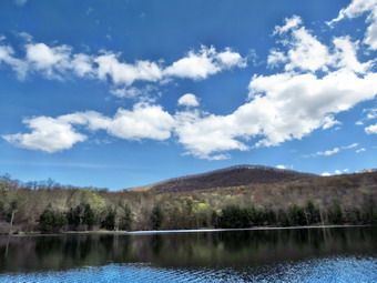 At the outlet end of the pond we stopped to take pictures of Cabot Mountain at the upper end of the pond and of the pond itself. This was a place I came with my wife's family many times for picnics. Sheila enjoyed running into the water but seemed reluctant to swim in the deep water. After taking some pictures, we headed around the pond on the near side. Workmen were getting the campgrounds ready to open by cleaning up and putting the swimming float in the water. The walk to the upper end of the pond went quickly as the trail is well-maintained. Lisa stopped to inspect her favorite campsite and then we continued around to the trail that leads up to the viewpoint and over TouchMeNot Mountain and back to the car. I turned on the trail and waited for Lisa but she continued around the pond. It was then that I found out that her "loop" and my "loop" where very different. I assumed we would stay on the trails while she had decided we would walk back on the roads. I HATE walking on roads when there is perfectly good trail! I walked back down to the trail around the pond. I stopped once to take some pictures of TouchMeNot Mountain. At this point I collapsed my poles and put them in my pack. I also put Sheila on her leash to make sure there were no problems on the road. One we completed the loop we started down the access road for the campgrounds to get to Barkaboom Road. It was torture for me since I do not like to walk on roads and neither does Sheila. Once we were at the Barkaboom Road we turned left and walked back uphill to the parking area at Big Pond. I took a few pictures of Big Pond before getting in the car. We had walked 4.9 miles in 2 hours and 42 minutes and over half of this was on "paved" trail or roads. The elevation gain was about 1120 feet. I do not suggest the road walk but would encourage everyone to complete the loop and the beautiful trails in this area!
![]()
![]()
![]()
![]()
![]() On Monday, May 6th I was determined to hike Black Dome even though the drive is long and I had track practice in the afternoon. On Saturday I had wanted to hike both Thomas Cole and Black Dome from Barnum Road but my wife could only manage Cole. I decided to hike Black Dome from the Batavia Kill trailhead and get an early start which often eludes me! I left Livingston Manor at around 7:00 AM and made it to the Batavia Kill trailhead before 8:30 AM. When I left the house, I was surprised that my car had a thick layer of frost on the windshield. The temperature at the trailhead was only about 35 degrees but I knew it was going to get warmer throughout the day. I thought I was appropriately dressed with summer pants and a light windbreaker. As we started the hike I was surprised to find that the trail register was missing! The supports had been neatly sawn off at almost ground level. I thought I might find that it had been relocated farther up the trail but that was not the case. As we walked along it was clear that the trails were extremely dry even in places that often had standing or running water. We were able to keep up a brisk pace over the first mile of the hike and were averaging almost 2.5 mph. After about a mile the trail begins to get steeper and there are a large number of rocks to negotiate on the ascent. At about 1.5 miles the ascent gets very steep but is moderated by FIVE switchbacks as the trail approaches Lockwood Gap. One of the most impressive sights in the Catskills is the turn on the first switchback as Blackhead comes into view. Black Dome is higher but sort of hidden. The view of Blackhead is "in your face" and I always think for just a moment "No one could climb that!" even after numerous trips to the top! Just before 9:30 Am we were at Lockwood Gap and we turned right top start the even steeper ascent to the summit of Black Dome.
On Monday, May 6th I was determined to hike Black Dome even though the drive is long and I had track practice in the afternoon. On Saturday I had wanted to hike both Thomas Cole and Black Dome from Barnum Road but my wife could only manage Cole. I decided to hike Black Dome from the Batavia Kill trailhead and get an early start which often eludes me! I left Livingston Manor at around 7:00 AM and made it to the Batavia Kill trailhead before 8:30 AM. When I left the house, I was surprised that my car had a thick layer of frost on the windshield. The temperature at the trailhead was only about 35 degrees but I knew it was going to get warmer throughout the day. I thought I was appropriately dressed with summer pants and a light windbreaker. As we started the hike I was surprised to find that the trail register was missing! The supports had been neatly sawn off at almost ground level. I thought I might find that it had been relocated farther up the trail but that was not the case. As we walked along it was clear that the trails were extremely dry even in places that often had standing or running water. We were able to keep up a brisk pace over the first mile of the hike and were averaging almost 2.5 mph. After about a mile the trail begins to get steeper and there are a large number of rocks to negotiate on the ascent. At about 1.5 miles the ascent gets very steep but is moderated by FIVE switchbacks as the trail approaches Lockwood Gap. One of the most impressive sights in the Catskills is the turn on the first switchback as Blackhead comes into view. Black Dome is higher but sort of hidden. The view of Blackhead is "in your face" and I always think for just a moment "No one could climb that!" even after numerous trips to the top! Just before 9:30 Am we were at Lockwood Gap and we turned right top start the even steeper ascent to the summit of Black Dome.
 The ascent from the Gap to the summit is relatively short but very steep in places. There are a few places that require some scrambling up and over large rocks and I wondered how Sheila would handle these. After I watched her simply jump up over the first few, I had my answer. On the way up there were several nice views and a viewpoint just above one of the climbs. I decided to push to the summit and stop on the way back down. The final .6 miles seemed to go quickly as we walked over the summit to the lookout facing south. The rock ledge that makes up the lookout was covered in "engravings" that have accumulated over the years. The views of the Devil's Path were better than I had expected but the skies were actually too clear with almost no clouds. I took some pictures and then we started the trip back. This time we stopped at the viewpoint that has a clear view of Blackhead, Colgate Lake and a hint of the Hudson River. This was the first time I noticed that the trail up Blackhead was so clearly visible. After taking some pictures, we returned to the trail to descend to the Gap. I was tempted to hike up Blackhead but decided I had accomplished my goal and had other commitments that need my attention. We made the left turn and started down through the switchbacks to the parking area. On the way down we met two solo hikers enjoying the beautiful day. The trip back seemed to go quickly but took about the same time as the trip up due to my photographic efforts. We arrived back at the car at 11:25 AM to find the temperature had risen to 64 degrees. This was almost a 30 degree changed from the beginning of the hike! We hiked 4.9 miles in just under 3 hours with almost a half hour of stopped time for photography. The total elevation gain was about 1830 feet.
![]()
![]()
![]()
![]()
![]() On Saturday, May 4th we did not had a track meet as we had attended an invitational on Friday evening. I had planned to fill in some of my grid for May and one look told me that Thomas Cole and Black Dome were a viable choice. I asked Cindy the night before if she would like to go and she was not sure. I woke up pretty early in the morning and gathered all my equipment. Cindy decided she would like to go. I knew that she might not be able to do both mountains but I like her company on hikes! We got ready, put Sheila in the car and headed out DeBruce Road toward Route 47 passed Slide Mountain just before 9:00 AM. The Frost Valley Road STILL has a "Closed" sign and the road is STILL only one lane just passed the intersection with Pole Road. Much of the road until after the hairpin turn is in very poor shape. When we got to Route 28, I turned right and then took Route 42 in Shandaken and headed toward Lexington and Route 23A. At Route 23A I turned right and headed toward Hunter. From there it was north on Route 296, east on Route 23C. north on Route 40 until, I turned right on Barnum Road. The small parking area on the right at the end of the road was full so I parked on the other side. When we got out of the car at 10:15 AM, we were surprised that it was so warm! We started hiking at about 10:20 AM by starting up the rocky path that forms the first part the of the hike. The first .5 miles of the hike has private land on both sides so I kept Sheila on her leash until we made the left turn and started to climb. The path was dry in most spots but had a few very muddy places. After the trail register, the trail began to climb almost immediately. It is pretty steep in some places but has a few switchbacks to moderate the ascent. In addition, there area some areas where the trail flattens before the next climb. By 11:00 AM we were at a short rock scramble which had a viewpoint at the end. I remembered this lookout and I dropped my pack to get the camera while Cindy took a breather. The viewpoint faced south and east so that I could see Onteora Mountain and the Jewett Range with the Devil's Path behind them. I took some pictures and then moved to a second lookout that had a view less obstructed by trees. The sky was almost cloudless and the sun was bright which is not a good combination for taking pictures but I took some anyway. We got back on the trail to continue our hike to Thomas Cole.
On Saturday, May 4th we did not had a track meet as we had attended an invitational on Friday evening. I had planned to fill in some of my grid for May and one look told me that Thomas Cole and Black Dome were a viable choice. I asked Cindy the night before if she would like to go and she was not sure. I woke up pretty early in the morning and gathered all my equipment. Cindy decided she would like to go. I knew that she might not be able to do both mountains but I like her company on hikes! We got ready, put Sheila in the car and headed out DeBruce Road toward Route 47 passed Slide Mountain just before 9:00 AM. The Frost Valley Road STILL has a "Closed" sign and the road is STILL only one lane just passed the intersection with Pole Road. Much of the road until after the hairpin turn is in very poor shape. When we got to Route 28, I turned right and then took Route 42 in Shandaken and headed toward Lexington and Route 23A. At Route 23A I turned right and headed toward Hunter. From there it was north on Route 296, east on Route 23C. north on Route 40 until, I turned right on Barnum Road. The small parking area on the right at the end of the road was full so I parked on the other side. When we got out of the car at 10:15 AM, we were surprised that it was so warm! We started hiking at about 10:20 AM by starting up the rocky path that forms the first part the of the hike. The first .5 miles of the hike has private land on both sides so I kept Sheila on her leash until we made the left turn and started to climb. The path was dry in most spots but had a few very muddy places. After the trail register, the trail began to climb almost immediately. It is pretty steep in some places but has a few switchbacks to moderate the ascent. In addition, there area some areas where the trail flattens before the next climb. By 11:00 AM we were at a short rock scramble which had a viewpoint at the end. I remembered this lookout and I dropped my pack to get the camera while Cindy took a breather. The viewpoint faced south and east so that I could see Onteora Mountain and the Jewett Range with the Devil's Path behind them. I took some pictures and then moved to a second lookout that had a view less obstructed by trees. The sky was almost cloudless and the sun was bright which is not a good combination for taking pictures but I took some anyway. We got back on the trail to continue our hike to Thomas Cole.
 Over the next .3 miles we continued to climb the Caudal to about 3300 feet. The descent on the other side took us down almost 100 feet before we climbed to the top of the Camel's Hump at over 3500 feet. There has been some discussion about naming the Camel's Hump as another 3500 foot peak but the distance between it and Thomas Cole is only about .8 miles and the drop from the Hump is just over 100 feet. The views from the Camel's Hump were pretty good as we stopped to rest for a few minutes on the rock at the top. Someone has cleared out some of the brush so that there are good views to the north of Windham. After a snack and a drink, we headed down the other side of the Hump just as the noon whistles were blowing and across the relatively flat saddle between The Camel's Hump and Thomas Cole. The last .4 mile climb up Thomas Cole had us gaining about 460 feet. Just after we started the climb we stopped at another lookout to the south and I took a few more pictures. By the time we got to the top of Thomas Cole at 12:$% PM, Cindy was too tired to go on. As always I was disappointed at failing to reach my goal but the company was well worth it! Cindy offered to hang out until I walked over to Black Dome and back but I knew I wouldn't be comfortable with that arrangement. We turned around and started back making good time except when we got to the few short climbs. We were back at the car by 2:30 PM having covered 5.7 miles in 4 hours and 15 minutes. The total vertical gain was 2280 feet. We both agreed we would like to eat at Pancho Villa's in Tannersville. As always the meal was good!
On Friday, May 3rd, I decided to take our two-year-old grandson Bryce on a hike on Round Top behind our church in Livingston Manor. He had been out walking with our son and daughter-in-law before but this was his first "off road: adventure with use. We walked down the driveway and looked both ways as we crossed the street. The hill behind the church I pretty steep and I know this since Bryce remarked about the incline. At the top of the hill we turned left into the woods on a path or woods road that led us to a lookout over downtown Livingston Manor. Bruce seemed interested in looking at the post office and school, which he visits regularly, from a different angle. We then headed up through the woods with Bryce holding my hand as we hopped over roots and branches and rocks. I decided to cut my planned route a little short and this is what got us into some trouble! We investigated some cliffs and rock overhangs and then headed back in the general direction of the church. Somehow on our way I missed the trail and dropped too low on the hill. We took a little spill but recovered with no harm done. Eventually we worked our way down to the back of the building next to the church. There were two well drilling trucks in the back and this made Bryce VERY happy! We walked back across the street to complete our 40 minute adventure. I am sure there will be many more and I look forward to them all!
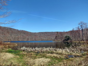
![]()
![]()
![]()
![]()
![]() On Wednesday, May 1st, I had planned to hike with Lisa starting at about 9:00 AM but and ambulance call in the early morning delayed those plans. When I got home at 10:00 AM I called Lisa and she was still interested and we agreed to hike at Huggins Lake. This hike is short but pretty and fit my time frame as I had a home track meet to set up. I picked Lisa up on the way and we headed for the Beaverkill campgrounds to cross the Beaverkill Covered Bridge. We found that the bridge was undergoing repairs so we too a short detour and ended up on Berry Brook Road headed toward our destination. When we arrived, we found the access road rutted but passable. I parked at about 10:40 AM and we got right to hiking. The weather was warm and sunny and I was glad I had dressed more appropriately than usual. We set a pretty fast pace and I was reminded that the woods road leading to the lake gains elevation more quickly than I remember. In the first .7 miles the trail gains about 500 feet before leveling off and then ascending again to the highest point at 2515 feet. After 1.24 miles and a gain of a little over 600 feet, we began the descent to the lake. We could see the he e below through the trees and it was a beautiful sight. By 1125 we had hiked the 1.9 miles and descended to the shore of the lake.
On Wednesday, May 1st, I had planned to hike with Lisa starting at about 9:00 AM but and ambulance call in the early morning delayed those plans. When I got home at 10:00 AM I called Lisa and she was still interested and we agreed to hike at Huggins Lake. This hike is short but pretty and fit my time frame as I had a home track meet to set up. I picked Lisa up on the way and we headed for the Beaverkill campgrounds to cross the Beaverkill Covered Bridge. We found that the bridge was undergoing repairs so we too a short detour and ended up on Berry Brook Road headed toward our destination. When we arrived, we found the access road rutted but passable. I parked at about 10:40 AM and we got right to hiking. The weather was warm and sunny and I was glad I had dressed more appropriately than usual. We set a pretty fast pace and I was reminded that the woods road leading to the lake gains elevation more quickly than I remember. In the first .7 miles the trail gains about 500 feet before leveling off and then ascending again to the highest point at 2515 feet. After 1.24 miles and a gain of a little over 600 feet, we began the descent to the lake. We could see the he e below through the trees and it was a beautiful sight. By 1125 we had hiked the 1.9 miles and descended to the shore of the lake.
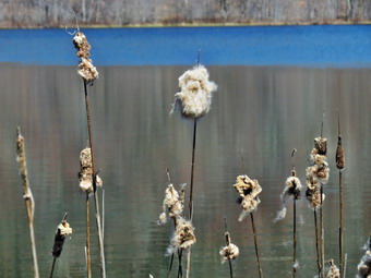 At the lake there were some large birds that took to flight as we approached but we could not see what they were. The geese on the lake stayed put and did not seem threatened by our presence. The lake was a nice blue and there was some color beginning to show in the buds and leaves on the trees. We stopped to take some pictures even though the bright sun and cloudless sky made that difficult. I concentrated on taking a few shots of some reeds with their spent seed pods. I also photographed the lake which sits in a kind of bowl surrounded by hills. Sheila and I walked to the outlet and to the small clearing beyond. I noticed that a woods road continues away from the pond in a generally north or northeast direction and I made to note to investigate it at some point. Lisa also took some pictures of the flowers that were beginning to show up. As we got ready to start back, Sheila hit the water splashing and swimming in the lake. Once she gets wet she it hard to stop as she loves the water! We started back up the woods road with Sheila racing passed us in both direction. We were back at the car by 12:25 PM having covered 3.7 miles in an hour and 45 minutes. It was not a long hike but a pleasant one that fit into the time we had available.
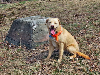
![]()
![]()
![]()
![]()
![]() On Sunday, April 28th I asked Cindy if she wanted to hike after church. She agreed and I suggested that we go to Bramley Mountain near Delhi. Bramley is on DEP land and was the site of a fire tower which was sold and dismantled. Lately the Catskill Mountain Club has been preparing to blaze some trails in the area and there has even been talk of erecting the fire tower. Cindy and I got our gear, put Sheila in the car and headed to Delhi. We continued through town going east on Route 10. In East Delhi we crossed the river at the Fitches Covered Bridge and then turned left on County Route 18. After about 2 miles we turned right on Glen Burnie Road and started to look for DEP signs. After a little over .5 miles there was a woods road on the left with a gate and some room to pull over on the side of the road. I drove a little further and found another road with another pulloff. I got out my hiking GPS and decided that the lower road looked more promising so we drove back down and parked there to begin our hike. The blackflies were out in force and the temperature was in the high 60's. I had traded in my Mammut Hoody for a light windbreaker and my Patagonia capilene for a lighter long-sleeved shirt. I was glad I did but I was still warm. We started hiking on the wide woods road heading east. Eventually the roads seemed to be running on contour and I wanted to gain some elevation. We turned south and started to bushwhack up a 30% grade. At he top we found another path and eventually a woods road which we followed for a while. At some point I found another road that seemed to go up to the ridge but that ended in a sea of old pricker canes. We followed a faint path along the edge of the sea until another road led us to the top of the ridge. The road we were on ended on a nice wide woods road that seemed to run east-west. I followed it east but it started to skirt the summit of the mountain. Once again we struck out on a bushwhack through some prickers toward the summit. Within a short distance we ran into a small cliff band but Sheila found an easy way through.
On Sunday, April 28th I asked Cindy if she wanted to hike after church. She agreed and I suggested that we go to Bramley Mountain near Delhi. Bramley is on DEP land and was the site of a fire tower which was sold and dismantled. Lately the Catskill Mountain Club has been preparing to blaze some trails in the area and there has even been talk of erecting the fire tower. Cindy and I got our gear, put Sheila in the car and headed to Delhi. We continued through town going east on Route 10. In East Delhi we crossed the river at the Fitches Covered Bridge and then turned left on County Route 18. After about 2 miles we turned right on Glen Burnie Road and started to look for DEP signs. After a little over .5 miles there was a woods road on the left with a gate and some room to pull over on the side of the road. I drove a little further and found another road with another pulloff. I got out my hiking GPS and decided that the lower road looked more promising so we drove back down and parked there to begin our hike. The blackflies were out in force and the temperature was in the high 60's. I had traded in my Mammut Hoody for a light windbreaker and my Patagonia capilene for a lighter long-sleeved shirt. I was glad I did but I was still warm. We started hiking on the wide woods road heading east. Eventually the roads seemed to be running on contour and I wanted to gain some elevation. We turned south and started to bushwhack up a 30% grade. At he top we found another path and eventually a woods road which we followed for a while. At some point I found another road that seemed to go up to the ridge but that ended in a sea of old pricker canes. We followed a faint path along the edge of the sea until another road led us to the top of the ridge. The road we were on ended on a nice wide woods road that seemed to run east-west. I followed it east but it started to skirt the summit of the mountain. Once again we struck out on a bushwhack through some prickers toward the summit. Within a short distance we ran into a small cliff band but Sheila found an easy way through.
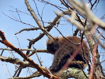 I was a little ahead of Cindy as we climbed through the cliffs. I looked down to see a sort of den and wondered what might live there. Once I got up through the cliffs I waited for Cindy. She called up to me that there was an animal moving in the tree above me. I looked around and finally spotted a porcupine in the tree. I took some pictures as she climbed up and then we both walked east and up a little to the clearing that marked the summit of the mountain. The piers for the fir tower were still there and I found a USGS benchmark in one of the rocks. There was a little path to the south side of the summit and I walked over to find some nice views. The skies were beginning to cloud over and the sun was too bright to get too many good shots. We walked back the way we had come and were soon on the wide woods road. We decided to stay on the road as long as it headed generally west. I was a little worried about private property but my recollection of the maps was that the DEP land was a rather large parcel. We continued to walk on the woods road and each time I thought we should be heading more north the road turned that way. I began to get the feeling that the road would come very close to the upper parking spot, the one that I had rejected at the beginning of the hike. Soon I could see the road and just after that the little pulloff. Once on the road we walked downhill to the car. We had covered 2.9 miles in 2 hours and 15 minutes with a vertical gain of a little over 900 feet. The trip to the summit had taken us about 1 hour and 20 minutes while the return trip on the woods road was about 40 minutes. I know which one I'll pick next time. We drove over to the other side of mountain and turned onto Bramley Mountain Road. The Venture Out map showed a parking area but we did not see it. We continued over to Route 10 with the intention of going through Andes and back by way of the Pepacton Reservoir. As we turned onto Route 10 we came across a beautiful stone church, St James Episcopal Church. I stopped to take a few pictures and wondered about the story behind this large church in such a rural setting.
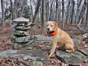
![]()
![]()
![]()
![]()
![]() On Friday, April 26th we had finished hiking Ticetonyk Mountain by noon and had headed for Mount Tobias. I drove back out to Route 28 and headed west through Boiceville. I turned right on Winnie Road and right onto the Mt Tremper-Wittenberg Road at end. After about 1.2 miles, I turned left on Abbey Road which started to climb almost immediately. maps I had seemed to indicate Abbey Road might be a narrow dirt road but I found it paved most of the way with many nice homes right to the dead end. I knew I was looking for a parking area on the right but could not find one! I drove back down the road to a sharp turn where The Middle Way branched off to the east. I turned around and tried to find The High Road but could not find that sign. An unsigned road went off to the left and right above that was a short, eroded access road. I had seen this before and noticed some sign at the end near what looked like a clearing. I assumed they were "Private Property" signs but decided to park my car and take a look. The signs indicated state land! I went back to the car and negotiated the deep ruts and parked in the small lot at about 12;40 PM. The summit of Mount Tobias was ENE of where we parked but private property was again an issue. We started out on a woods road that left the parking area and headed almost due north. The road was easy to follow but after about .25 miles I decided to turn east in the direction of Mount Tobias. The road seemed to fork but the branch to the east was difficult to follow so we picked our own path. At about .45 miles we ran up against some cliffs with areas that looked like they could be climbed but I decided to walk along them to look for a better approach. It wasn't long before I found and area and we started up heading northeast. The next .35 miles saw us gain about 380 feet on a 20% grade. At .9 miles we hit a relatively flat summit plateau and headed almost due east toward the highest point. I was not aware of a USGS marker on the top but found a cairn near what I thought was the highest point.
On Friday, April 26th we had finished hiking Ticetonyk Mountain by noon and had headed for Mount Tobias. I drove back out to Route 28 and headed west through Boiceville. I turned right on Winnie Road and right onto the Mt Tremper-Wittenberg Road at end. After about 1.2 miles, I turned left on Abbey Road which started to climb almost immediately. maps I had seemed to indicate Abbey Road might be a narrow dirt road but I found it paved most of the way with many nice homes right to the dead end. I knew I was looking for a parking area on the right but could not find one! I drove back down the road to a sharp turn where The Middle Way branched off to the east. I turned around and tried to find The High Road but could not find that sign. An unsigned road went off to the left and right above that was a short, eroded access road. I had seen this before and noticed some sign at the end near what looked like a clearing. I assumed they were "Private Property" signs but decided to park my car and take a look. The signs indicated state land! I went back to the car and negotiated the deep ruts and parked in the small lot at about 12;40 PM. The summit of Mount Tobias was ENE of where we parked but private property was again an issue. We started out on a woods road that left the parking area and headed almost due north. The road was easy to follow but after about .25 miles I decided to turn east in the direction of Mount Tobias. The road seemed to fork but the branch to the east was difficult to follow so we picked our own path. At about .45 miles we ran up against some cliffs with areas that looked like they could be climbed but I decided to walk along them to look for a better approach. It wasn't long before I found and area and we started up heading northeast. The next .35 miles saw us gain about 380 feet on a 20% grade. At .9 miles we hit a relatively flat summit plateau and headed almost due east toward the highest point. I was not aware of a USGS marker on the top but found a cairn near what I thought was the highest point.
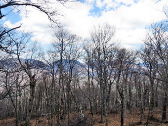 We stopped at the cairn and Sheila posed for a few pictures. After our photo shoot, we headed east and down a little to find a viewpoint. I tried several different places but could only get views through the trees. I took a few pictures and then we started back. On the way back I tried to get Sheila to follow the route we had taken up. Sheila is a hunting dog where Sheba was a working dog. Sheila just has to follow her nose and sniff out various animal tracks. If I remind her, she comes back to our track but her approach is serpentine to say the least. On the way back I stayed a little to the north of our previous path and we ran into the cliffs we had seen from below. It was a s simple matter to walk along the cliffs until a suitable spot to descend became available. Once we were down off the higher ground we hit our track back to the woods road. As we walked along the road, Sheila turned to the left and I called her to continue straight ahead. Something told me to check compass and GPS both of which proved Sheila correct. We turned left on the branch of the woods road that took us right back to the car by 2:15 PM. This hike was only 2.3 miles and had taken about 1.5 hours. There was an overall 700 foot vertical gain. Despite the lack of any real views from the top, I liked the cliffs and would return to climb them or perhaps try a different approach from Route 212 to the north.
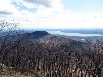
![]()
![]()
![]()
![]()
![]() On Friday, April 26th I had my eyes set on some new Catskill peaks that I had seen mentioned in online forums as interesting. Some of these are on a list called the "Catskill's Finest" which lists peaks based on prominence. Prominence can be a difficult concept to explain especially since the definition varies from person to person and place to place. Basically it describes how much a mountain "sticks out" from the terrain and other mountains around it. Some of the peaks I had in mind were Ticetonyk, Mount Tobias, and Carl Mountain in the Ashokan Reservoir area. Bramley Mountain and another hill near the Pepacton Reservoir also sounded interesting. I decided to head toward Ticetonck first and drove from Livingston Manor to Grahamsville and then out passed Peekamoose to West Shokan. In West Shokan I took Route 28A north to Route 28 heading east towards Kingston. I turned north onto some back roads and made my way to Peck Road. I found a DEP parking area on the left side of the road which did not appear to be correct. I continued until I had driven about 1.2 miles on Peck road. There was a small pulloff on the left side of the road with a small sign announcing Ticetonyk Mountain. I parked to one side of pulloff to allow at least one other car access although I doubted anyone else would be at this obscure spot on a Friday! When we got out of the car at 9:40 AM, the first thing that I noticed was the swarm of black flies! I remembered that I had forgotten to bring any repellant! I also noticed the day was already warm and I wondered how long I could keep on my Mammut softshell. As we started the hike, I was cognizant of the fact that the access to the larger parcel of land is a very narrow corridor with private land on either side. I noticed the state forest signs and tried to keep between the signs and the yellow blazes that marked the corridor. Although our destination, the summit of Ticetonyk Mountain was also due north of our location, we headed northwest to stay on the state land. I was able to follow several indistinct paths and wood road until, I found one that headed northwest and up the western shoulder of the ridge. At about .45 miles this road began to rise steeply to about .75 miles were it leveled off. As we climbed, I noticed some great views of the Ashokan Reservoir to the left. Once the road leveled off, I stopped and took a few pictures even though there were some trees blocking the views.
On Friday, April 26th I had my eyes set on some new Catskill peaks that I had seen mentioned in online forums as interesting. Some of these are on a list called the "Catskill's Finest" which lists peaks based on prominence. Prominence can be a difficult concept to explain especially since the definition varies from person to person and place to place. Basically it describes how much a mountain "sticks out" from the terrain and other mountains around it. Some of the peaks I had in mind were Ticetonyk, Mount Tobias, and Carl Mountain in the Ashokan Reservoir area. Bramley Mountain and another hill near the Pepacton Reservoir also sounded interesting. I decided to head toward Ticetonck first and drove from Livingston Manor to Grahamsville and then out passed Peekamoose to West Shokan. In West Shokan I took Route 28A north to Route 28 heading east towards Kingston. I turned north onto some back roads and made my way to Peck Road. I found a DEP parking area on the left side of the road which did not appear to be correct. I continued until I had driven about 1.2 miles on Peck road. There was a small pulloff on the left side of the road with a small sign announcing Ticetonyk Mountain. I parked to one side of pulloff to allow at least one other car access although I doubted anyone else would be at this obscure spot on a Friday! When we got out of the car at 9:40 AM, the first thing that I noticed was the swarm of black flies! I remembered that I had forgotten to bring any repellant! I also noticed the day was already warm and I wondered how long I could keep on my Mammut softshell. As we started the hike, I was cognizant of the fact that the access to the larger parcel of land is a very narrow corridor with private land on either side. I noticed the state forest signs and tried to keep between the signs and the yellow blazes that marked the corridor. Although our destination, the summit of Ticetonyk Mountain was also due north of our location, we headed northwest to stay on the state land. I was able to follow several indistinct paths and wood road until, I found one that headed northwest and up the western shoulder of the ridge. At about .45 miles this road began to rise steeply to about .75 miles were it leveled off. As we climbed, I noticed some great views of the Ashokan Reservoir to the left. Once the road leveled off, I stopped and took a few pictures even though there were some trees blocking the views.
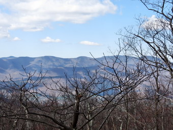 At this point the road continued to the northwest and started to descend. Since I did not want to descend or to infringe on private property, we turned northeast and headed up a short but steep (30%) ascent. The trail became a little less demanding after only .1 miles. We continued to climb up the shoulder of the mountain until the faint path we were following flattened out and we reached the summit at about 1.4 miles. I knew there was a USGS marker at the top which I found on one of the larger rocks. I knew from previous trip reports that there was a lookout to the east so we headed a little to the south east and won a level toward what looked like the edge of some cliffs. Once we were near that edge we began to walk east and then north looking for the viewpoint. Soon I found a great lookout with a large rock inscribed with many initials and symbols. There were open views to the east over the reservoir with Tonshi Mountain just below. I took many pictures despite a slight haze and bright sunlight. After photographing as much as I could, I decided we would stay on this lower level and try to walk around to the west to see if there were any open views. We walked for a little along the eastern edge but began to get into THICK laurel as we headed north. I decided to cut back up to the summit plateau and had to fight through the laurel to get there! Once we cleared the laurel, we headed to the western edge where I found some nice views but limited photographic opportunities. We continued around until we hit the path we had taken to the summit and turned southwest to retrace our route. After only a short distance, Sheila, who was just ahead of me, began to bark as if someone was approaching. This was because someone was approaching. I had not expected to find anyone else in this rather remote location but I was wrong. The hiker lived locally and we talked about the views and the beautiful weather. After our brief conversation, we parted and Sheila and I continued back down to the woods road. This time we stayed on the woods road a little longer which made the return trip slightly longer but a little easier. I again tried to stay on the state land. We were back at the car by noon having hiked 3.4 miles in 2 hours and 20 minutes. The vertical gain was 1350 feet. I was happy that the slight breeze had kept the black flies at bay! Even though I was a little tired, I decided to head to Mount Tobias.
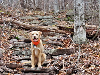
![]()
![]()
![]()
![]()
![]() On Tuesday, April 23rd I wanted to hike somewhere relatively close but could not face another trip to Frick Pond! I decided to hike Slide Mountain and made plans to hike up the Steps Trail. Note: The Steps Trail is partly on Winnisook Club Property so be sure to call the club for permission. I have never been denied but you must ask. I drove out Pole Rd. to Route 47 and made the left turn toward Frost Valley. There is still a "Road Closed" sign but the road is being used. The condition of the road just after the sign has deteriorated even further over the winter. The rest of the trip to the parking area was uneventful and we arrived at about 9:00 AM to find a group of four hikers getting ready to start. I delayed a little to let them get a head start and left the parking area at about 9:10 AM. The river was easy to cross and there was no snow or ice in sight. Sheila splashed through the water and ran up the trail. The hikers ahead of us looked like they would be staying overnight somewhere as they had larger packs and were moving slowly. We caught up to them and I found they intended to hike to the top of Slide and then take the Curtis-Ormsbee Trail To Denning. From there they were planning on staying at the Table lean-to overnight. We passed them and turned left when we got to the woods road. After a short walk, we turned into the woods just short of where the Winnisook Club has their cable across the road. It was pretty easy to find the Steps Trail although it was a little overgrown in places as it is much less sued than the other trails. We climbed a little and at about .7 miles stopped at the first lookout. There was a fog or mist hanging over the surrounding peaks and it even obscured the valleys between. I took a few shots and then we continued along a relatively flat section before climbing again. There were a few blowdowns to avoid but the trail was pretty easy to follow. Somewhere along the way I took a few pictures of Sheila on some of the steps. We continued to follow the trail as it took a generally gentle approach. At about 1.7 miles we came to some rocks that form another lookout. Before climbing to the lookout, I took some pictures of the rocks. To get up required me to grab onto some roots but Sheila just ran up the rocks.
On Tuesday, April 23rd I wanted to hike somewhere relatively close but could not face another trip to Frick Pond! I decided to hike Slide Mountain and made plans to hike up the Steps Trail. Note: The Steps Trail is partly on Winnisook Club Property so be sure to call the club for permission. I have never been denied but you must ask. I drove out Pole Rd. to Route 47 and made the left turn toward Frost Valley. There is still a "Road Closed" sign but the road is being used. The condition of the road just after the sign has deteriorated even further over the winter. The rest of the trip to the parking area was uneventful and we arrived at about 9:00 AM to find a group of four hikers getting ready to start. I delayed a little to let them get a head start and left the parking area at about 9:10 AM. The river was easy to cross and there was no snow or ice in sight. Sheila splashed through the water and ran up the trail. The hikers ahead of us looked like they would be staying overnight somewhere as they had larger packs and were moving slowly. We caught up to them and I found they intended to hike to the top of Slide and then take the Curtis-Ormsbee Trail To Denning. From there they were planning on staying at the Table lean-to overnight. We passed them and turned left when we got to the woods road. After a short walk, we turned into the woods just short of where the Winnisook Club has their cable across the road. It was pretty easy to find the Steps Trail although it was a little overgrown in places as it is much less sued than the other trails. We climbed a little and at about .7 miles stopped at the first lookout. There was a fog or mist hanging over the surrounding peaks and it even obscured the valleys between. I took a few shots and then we continued along a relatively flat section before climbing again. There were a few blowdowns to avoid but the trail was pretty easy to follow. Somewhere along the way I took a few pictures of Sheila on some of the steps. We continued to follow the trail as it took a generally gentle approach. At about 1.7 miles we came to some rocks that form another lookout. Before climbing to the lookout, I took some pictures of the rocks. To get up required me to grab onto some roots but Sheila just ran up the rocks.
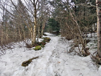 The view from the lookout was nonexistent as the warm air hitting the cold snow formed an impenetrable ground fog. I did take a few pictures of trees surrounded by fog which looked interesting. As we started up the trail, we immediately ran into several inches of snow on the ground. It was pretty hard but was also icy in places. The Steps Trail becomes less distinct near the junction with the main trail so I kept asking Sheila which way to go. I followed her until we were...right on the main trail to the summit. The main trail was covered in a foot or so of hard packed snow and ice and there was still some snow in the woods. We turned left to go to the summit and walked for a while without too many slips or slides. Once we passed the Curtis-Ormsbee Trail junction, we ran into some icier patches and I decided to put on my spikes. This turned out to be a GREAT decision and I wore them to the summit and back down. We stopped at the lookout before the summit and again had no views. We walked passed the summit to the open rock face and found no snow in this area. The rocks and the clearing next to them are more open and all the snow had melted. It was 11:00 AM. I took a few minutes to take some pictures of the fog moving across the clearing before starting back down the trail. The spikes made descending pretty easy! Somewhere around the trail junction I met the group of four hikers coming up. None of them had any spikes and I told them that they could probably make it to the summit but they would have to walk on the side of the trail in the icier spots. We went our separate ways. The ice and snow suddenly disappeared completely just after where we had joined the main trail from the Steps trail at about 3700 or 3800 feet. We continued down the main trail crossing a few small streams and climbing over or walking around some areas of blowdown. We met two young men coming up the trail and I mentioned the snow and ice ahead. I have never liked this part of the trail as it seems long and there are so many rocks. On this day the hike down seemed to go quickly and we were soon at the junction with the Phoenicia-West Branch trail. We turned right and walked to the trail junction and then down the trail to the parking area. We were back by 12:30 PmM having covered 5.5 miles in 3 hours and 20 minutes with over 30 minutes of stopped time. Our vertical gain was about 1840 feet.
![]()
![]()
![]()
![]() On Wednesday, April 17th I decided to hike locally before going to school to get our track ready for the first home meet. We had not been to Long Pond for some time so I decided we would go there despite the fact that the trails are always wet and muddy! We arrived at the parking area just before 9:30 AM and started hiking right away. In the first .7 miles we gained 350 feet but this was pretty much the only ascent of the day. There was some water on this part of the trail but nothing we couldn't avoid. At 1 mile there was a side trail down to Long Pond. I decided for the second hike in a row that pictures were not necessary. On this day the sky was bright and almost cloudless which did not make for ideal conditions for photography. After passing the trail to the pond, the main trail started to get much wetter with some small puddles and muddy areas. At 1.3 miles we arrived at the trail junction. The trail to the left leads back out to Flugertown Road for a very short loop. We turned right to continue on the longer loop. At 1.7 miles there was a trail to the right that goes to the lean-to but we continued on the main trail. We had passed several "ponds" on the trail which were also very muddy and I was happy that Sheila avoided the mess. At 2.4 miles the trail ended on a woods road where we turned left and walked down to the junction with Basily Road at 2.75 miles. Turning right here would have taken us to Wild Meadow Road so we stayed to the left to head back to Flugertown Road. At 3.25 miles we crossed a small stream and walked through the Peters hunting camp crossing another stream in the process. Just after crossing the second stream the road made a sharp turn to the left and we followed. For the next 2 miles the road was a solid dirt surface and we made good time. The walk was pleasant as the road parallels Willowemoc Creek. Toward the end of this section I was surprised to look up and see a pickup truck coming toward us. I grabbed Sheila and decided it was time to put her on her leash. I was glad I did since two more vehicles eventually passed us. This is considered "rush hour" for this back road! At 5.4 miles we passed the dirt road to Sand Pond on the right and at that point Flugertown Road became a paved and maintained town road. It was only .5 miles back to the car. We arrived in the parking area at 11:30 AM having covered 5.9 miles in 2 hours with only 13 seconds of stopped time.
On Wednesday, April 17th I decided to hike locally before going to school to get our track ready for the first home meet. We had not been to Long Pond for some time so I decided we would go there despite the fact that the trails are always wet and muddy! We arrived at the parking area just before 9:30 AM and started hiking right away. In the first .7 miles we gained 350 feet but this was pretty much the only ascent of the day. There was some water on this part of the trail but nothing we couldn't avoid. At 1 mile there was a side trail down to Long Pond. I decided for the second hike in a row that pictures were not necessary. On this day the sky was bright and almost cloudless which did not make for ideal conditions for photography. After passing the trail to the pond, the main trail started to get much wetter with some small puddles and muddy areas. At 1.3 miles we arrived at the trail junction. The trail to the left leads back out to Flugertown Road for a very short loop. We turned right to continue on the longer loop. At 1.7 miles there was a trail to the right that goes to the lean-to but we continued on the main trail. We had passed several "ponds" on the trail which were also very muddy and I was happy that Sheila avoided the mess. At 2.4 miles the trail ended on a woods road where we turned left and walked down to the junction with Basily Road at 2.75 miles. Turning right here would have taken us to Wild Meadow Road so we stayed to the left to head back to Flugertown Road. At 3.25 miles we crossed a small stream and walked through the Peters hunting camp crossing another stream in the process. Just after crossing the second stream the road made a sharp turn to the left and we followed. For the next 2 miles the road was a solid dirt surface and we made good time. The walk was pleasant as the road parallels Willowemoc Creek. Toward the end of this section I was surprised to look up and see a pickup truck coming toward us. I grabbed Sheila and decided it was time to put her on her leash. I was glad I did since two more vehicles eventually passed us. This is considered "rush hour" for this back road! At 5.4 miles we passed the dirt road to Sand Pond on the right and at that point Flugertown Road became a paved and maintained town road. It was only .5 miles back to the car. We arrived in the parking area at 11:30 AM having covered 5.9 miles in 2 hours with only 13 seconds of stopped time.
![]()
![]()
![]()
![]() On Monday, April 15th I decided to hike locally after a 12 mile adventure in Minnewaska on Saturday. The Hodge and Frick Pond area seemed as good as any so I got Sheila in the car and we headed out arriving at the parking area at 9:35 AM. We were ready to go almost immediately although I was surprised that the temperature was just above freezing since the forecast called for highs in the mid-50s. I thought I might choose a slightly different route so we headed out the Quick Lake Trail toward Frick Pond but turned right onto the Loggers Loop at the first trail junction. The trails were VERY wet and soft but the worst areas could be avoided by walking around them. At Times Square we turned right and headed up the Big Rock Trail toward the junction with the Flynn Trail. This is one of the most challenging climbs in this area. The skies remained overcast but the ascent warmed me up. Sheila was having great fun investigating the numerous animal trails. By 10:20 AM we were at the junction with the Flynn Trail after hiking a little over 2 miles. Our pace was so good that I decided to simply hike for speed and avoid any stops. We turned left on the Flynn Trail and headed toward Hodge Pond. At the next trail junction we headed right on the woods road toward the old Beech Mountain Boy Scout Camp. As we approached the old building, we turned right to head down to the jeep trail around the pond where we took a right. We walked around the back of the pond and joined the Flynn Trail on the other side. We turned right to get on the Flynn Trail and head toward Junkyard Junction where it meets the Quick Lake Trail. There is still a large amount of blowdown blocking the short section of trail from the pond to the gate. Even after the gate there were several trees across the trail. The Flynn Trail in this area is nearly flat and there was a lot of water and mud in this area. By the time we reached Junkyard Junction we had hiked about 3.65 miles and it was just before 11:00 AM. We turned left to head down the Quick Lake Trail to Iron Wheel Junction. This part of the trail was all downhill and we were able to pick up our pace. The trail was wet in places and showed signs that there had been some running water not long ago. At Iron Wheel we continued straight ahead on the yellow blazed Loggers Loop. This had been my plan all along but I almost had decided to take the Quick Lake Trail back. Sheila me the decision by running straight ahead! The Loggers Loop was also wet in spots but we were able to walk around them. We walked the 1.25 mile trail to Times Square where we arrived at about 11:45 AM. I had thought we might walk around the back of Frick Pond on the wooden bridges but instead stayed straight to return on the Loggers Loop and Quick Lake Trails. As we walked the woods road back to the parking area we met to women hiking out to Frick Pond. I was surprised as I seldom see other hikers especially during the week. We were back at the car at 12:05 PM having covered 7.5 miles in 2.5 hours. The GPS showed we had stopped for less than 2 minutes.
On Monday, April 15th I decided to hike locally after a 12 mile adventure in Minnewaska on Saturday. The Hodge and Frick Pond area seemed as good as any so I got Sheila in the car and we headed out arriving at the parking area at 9:35 AM. We were ready to go almost immediately although I was surprised that the temperature was just above freezing since the forecast called for highs in the mid-50s. I thought I might choose a slightly different route so we headed out the Quick Lake Trail toward Frick Pond but turned right onto the Loggers Loop at the first trail junction. The trails were VERY wet and soft but the worst areas could be avoided by walking around them. At Times Square we turned right and headed up the Big Rock Trail toward the junction with the Flynn Trail. This is one of the most challenging climbs in this area. The skies remained overcast but the ascent warmed me up. Sheila was having great fun investigating the numerous animal trails. By 10:20 AM we were at the junction with the Flynn Trail after hiking a little over 2 miles. Our pace was so good that I decided to simply hike for speed and avoid any stops. We turned left on the Flynn Trail and headed toward Hodge Pond. At the next trail junction we headed right on the woods road toward the old Beech Mountain Boy Scout Camp. As we approached the old building, we turned right to head down to the jeep trail around the pond where we took a right. We walked around the back of the pond and joined the Flynn Trail on the other side. We turned right to get on the Flynn Trail and head toward Junkyard Junction where it meets the Quick Lake Trail. There is still a large amount of blowdown blocking the short section of trail from the pond to the gate. Even after the gate there were several trees across the trail. The Flynn Trail in this area is nearly flat and there was a lot of water and mud in this area. By the time we reached Junkyard Junction we had hiked about 3.65 miles and it was just before 11:00 AM. We turned left to head down the Quick Lake Trail to Iron Wheel Junction. This part of the trail was all downhill and we were able to pick up our pace. The trail was wet in places and showed signs that there had been some running water not long ago. At Iron Wheel we continued straight ahead on the yellow blazed Loggers Loop. This had been my plan all along but I almost had decided to take the Quick Lake Trail back. Sheila me the decision by running straight ahead! The Loggers Loop was also wet in spots but we were able to walk around them. We walked the 1.25 mile trail to Times Square where we arrived at about 11:45 AM. I had thought we might walk around the back of Frick Pond on the wooden bridges but instead stayed straight to return on the Loggers Loop and Quick Lake Trails. As we walked the woods road back to the parking area we met to women hiking out to Frick Pond. I was surprised as I seldom see other hikers especially during the week. We were back at the car at 12:05 PM having covered 7.5 miles in 2.5 hours. The GPS showed we had stopped for less than 2 minutes.
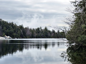
![]()
![]()
![]()
![]()
![]() On Saturday, April 13th I was ready to get out again after the rainy weather at the end of the week and some commitments that had kept me inside. I wanted to hike at least 8 miles and chose to go to Minnewaska Sate Park as I had not been there in some time. I thought it might be nice to see some waterfalls after the rains and the park has several choices. We arrived at about 10:00 AM and paid the $8 fee at the gatehouse. The forecast called for clearing skies later in the morning so I didn't mind arriving a little late. I decided to park in the upper lot and hike to Gertrude's Nose and then loop back to pass Awosting Falls before returning to the car. We were parked and ready to go at about 10:15 AM. The park is very popular but I thought it was a little early in the season for it to be too busy. I was wrong! The lot already had a dozen or more cars parked. Sheila and I walked down the hill to the "beach" and I took some pictures of the lake and the cliffs. The sky was very overcast but that made the lighting interesting. There were people along most of the paths and carriageways and I really wanted to find a less populated area. My idea was to walk to the other end of lake and then take the Millbrook Mountain Trail to get to Gertrude's Nose. My hope was to get away from some of the people! At the trail junction with the Hamilton Point Carriageway I met a young woman and her Jack Russell terrier, Oliver. She was also debating which way to go. Sheila and I headed down to the lake passing one group on the way with another right behind us. We stopped so that I could take some pictures as the other groups approached. I decided to hike back up to the trail junction and try taking the Millbrook Mountain Carriageway. Once on the carriageway we found no other hikers and, not seeing the young woman and her dog, I assumed they were ahead of us. Within a short distance the trail split with the Hamilton Point Carriageway bearing right. We went left to follow the Millbrook Mountain Carriageway. I kept Sheila on the leash as she didn't seem to mind much and didn't want to get in the way of any bikers. After about 2 miles of hiking we arrived at Patterson's Pellet at about 10:55 AM. I took some pictures and then we continued on our way making great time on the flat carriageway. At 2.5 miles we turned right onto the Gertrude's Nose Trail and I let Sheila off her leash. She was very happy to be free but came quickly when I called.
On Saturday, April 13th I was ready to get out again after the rainy weather at the end of the week and some commitments that had kept me inside. I wanted to hike at least 8 miles and chose to go to Minnewaska Sate Park as I had not been there in some time. I thought it might be nice to see some waterfalls after the rains and the park has several choices. We arrived at about 10:00 AM and paid the $8 fee at the gatehouse. The forecast called for clearing skies later in the morning so I didn't mind arriving a little late. I decided to park in the upper lot and hike to Gertrude's Nose and then loop back to pass Awosting Falls before returning to the car. We were parked and ready to go at about 10:15 AM. The park is very popular but I thought it was a little early in the season for it to be too busy. I was wrong! The lot already had a dozen or more cars parked. Sheila and I walked down the hill to the "beach" and I took some pictures of the lake and the cliffs. The sky was very overcast but that made the lighting interesting. There were people along most of the paths and carriageways and I really wanted to find a less populated area. My idea was to walk to the other end of lake and then take the Millbrook Mountain Trail to get to Gertrude's Nose. My hope was to get away from some of the people! At the trail junction with the Hamilton Point Carriageway I met a young woman and her Jack Russell terrier, Oliver. She was also debating which way to go. Sheila and I headed down to the lake passing one group on the way with another right behind us. We stopped so that I could take some pictures as the other groups approached. I decided to hike back up to the trail junction and try taking the Millbrook Mountain Carriageway. Once on the carriageway we found no other hikers and, not seeing the young woman and her dog, I assumed they were ahead of us. Within a short distance the trail split with the Hamilton Point Carriageway bearing right. We went left to follow the Millbrook Mountain Carriageway. I kept Sheila on the leash as she didn't seem to mind much and didn't want to get in the way of any bikers. After about 2 miles of hiking we arrived at Patterson's Pellet at about 10:55 AM. I took some pictures and then we continued on our way making great time on the flat carriageway. At 2.5 miles we turned right onto the Gertrude's Nose Trail and I let Sheila off her leash. She was very happy to be free but came quickly when I called.
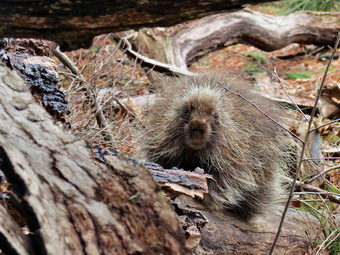 The trail climbed a small hill and then descended on the other side into a small ravine with a stream at the bottom. We crossed the stream easily as the trail began to climb toward Gertrude's Nose. The trail wound its way along the edge of the cliffs. I kept a close eye on Sheila as she likes to get right to the edge and look around. I was also concerned that she might get so interested in a bird or other wildlife that she might not notice the deep crevasses in the rocks. After watching her for a while, it was clear she was being very careful. I stopped to take some pictures of the rocks, the ravine and Hamilton Point. I looked back to see the woman I had talked to earlier taking her own pictures. We walked together to Gertrude's Nose stopping along the way to take some pictures. At Gertrude's Nose, I took some shots of the countryside below. The sun was peeking through the clouds at times but there was a haze hanging around. It was 11:55 AM and we had hiked 3.75 miles slowing down some once we hit the trails. We continued around Gertrude's Nose and stayed on the trail as it followed the escarpment. The views along the way were nice but not much different than from Gertrude's Nose. I was a little ahead with Sheila still off her leash when I noticed that she was very interested in something just off the right side of the trail. I took a look and found her headed toward a porcupine that was just sitting on a branch. I immediately called her and she reluctantly came to me. As the other dog and owner approached, I warned her only to look back and find the porcupine coming directly toward us! Sheila really wanted to get to the porcupine now that it was in motion so I was glad that it climbed a tree. As we continued along, the trail descended and crossed a powerline right-of-way. Just after this we stopped at a deep hole and I explained that during the summer the air here was MUCH cooler than anywhere else. At this point Oliver needed a little first aid for a cut on his back leg so we parted company.
 I climbed out of small ravine and put Sheila on her leash as a couple and their large back lab descended the rocky path I was climbing. I was glad they had there dog on a leash as it did not seem very friendly. At the top of the climb we met two different hiking groups who seemed to like dogs. We chatted briefly before Sheila and I continued along. We met several other hikers along the way and stopped once or twice so that I could take some pictures. As we approached Millbrook Mountain, Oliver and his owner caught up with us again. At this point it was 1:00 PM and we had hiked about 5.5 miles. The other hiker decided to head back to Minnewaska on the Millbrook Mountain Trail while decided to stick to my plan to complete a loop passed Awosting Falls. I thought about cutting down to the Coxing Kill Trail to shorten the hike a little but knew that trail was usually very wet. As we walked along the Millbrook Mountain Trail there were several nice views and I stopped at one to take some pictures including some of the talus below the cliffs. A father and daughter approached from the other direction. The daughter volunteered to take a picture of me with Sheila and I accepted. We talked for a moment before parting. Only a little further along I stopped again to take some pictures of the Catskills from the ridge we were on. We passed another connector trail but I decided to continue to Bayard's Path which was my original plan. The trail was rocky in many parts with a high wall of rock on the right. When the trail descended and moved away from the escarpment it became a tangle of roots. At 2:15 PM we had hike 7.6 miles and turned left onto Bayard's Path which made a short but steep descent to the Trapps Road where we turned left to head back toward Minnewaska.
 By this time I was feeling a little tired but Sheila was still ready to go! She dashed up and down the wide road running through the water in the ditch and generally having a great time. My feet were a little sore from the ribbed wool socks I was wearing but the flat carriageway was easier on them than the rocky trails. Trapps Road parallels Route 44/55 and I could hear and see the traffic. At one point the road makes a hairpin turn and passes by a high wall of rock on the left where we stopped to get a drink and for me to take some pictures. Just after this at about 9.6 miles we crossed Lyons Road. Shortly after this the name of the trail changed to the Awosting Falls Carriageway and a small sign announced it was "closed to all traffic". At this point, we didn't have much choice and I decided to continue wince turning back was not an option. There did seem to be tire tracks on the trail surface and quite a few foot prints. Soon we were at the access point from Route 44/55 where the Peters Kill crosses underneath the road. A gate and a sign indicated that the trail was closed but others seemed to be using it freely. I decided it was safer to take the trail rather than to walk on the road with the traffic. We stayed on the trail, and found it to be largely reconstructed with new crusher run sued to build the road surface. We stopped along the way so that I could take some pictures of the Peters Kill. The bed of the stream is solid rock and it is very shallow. An increase in volume inevitably sends the stream out of its banks to erode trail. At 3:25 PM we arrived at Awosting Falls after hiking 11 miles. We stopped and I took some pictures of the falls before we headed up the path to the top of the falls. There were several groups of hikers coming down to the falls even though it was late in the day. I though about stopping at the top of the falls but really just wanted to get back to the car. We turned right on the Sunset Carriageway and climbed back up toward the lake and the parking area. I was glad that Sheila still had some energy to help pull me up the hill! We were back at the car at 3:50 PM after hiking 12 miles in 5 hours and 40 minutes. We had stopped for over an hour along the way and ascended almost 2000 feet.
![]()
![]()
![]()
![]()
![]() On Tuesday, April 9th I wanted to get in another hike before the weather turned rainy for the remainder of the week. I decided to hike to Giant Ledge and maybe to Panther if time allowed. Another option I considered was bushwhacking below the Ledges to make somewhat of a loop. I got my gear and Sheila into the car and we started out at just after 9:00 AM. I had elected to wear by Keen Glarus boots rather than more insulated winter boots. I also did not don a baselayer as the temperature was already in the 50's when we headed out. I did not intend to use snowshoes since I knew I would have to carry them at the beginning of the hike. I decided that I would turn around if snowshoes became necessary! As I made the turn from Pole Rd. onto Route 47, the "Road Closed" sign was still present. The road just after the turn is still one lane and has not been paved. The rest of the road to Frost Valley and beyond was not in good shape with many holes and a lot of sand and gravel on the road surface. We passed a work crew doing some ditching. We arrived at the parking area at the hairpin turn on Route 47 and 9:45 AM and were ready to hike right away. There were no other cars in the lot as we crossed the road and headed out on the trail. The first part of the trail had quite a bit of ice but this gave way to almost bare trail just after the bridge. The bare spots were pretty muddy. A little further on the ice returned and the snow increased on the sides of the trail. I almost put on my spikes but the icy areas kept alternating with bare areas of dirt and rock. Walking on the sides of the trail in the icy areas seemed to be the best plan. Near the top of the climb to the trail junction the ice was spread across the trail so we bushwhacked off the trail to the junction. The area around the trail junction was icy and there was quite a bit of snow as we turned toward Giant Ledge. The rest of the way to the last steep climb continued to alternate between snow, ice, mud and water. The last climb was almost devoid of ice or snow as it is well exposed to the sun. At the top of the climb the snow returned as we walked to the path that goes down to the first lookout. We arrived at the first viewpoint at 10:55 AM having taken around an hour for the 1.6 mile hike.
On Tuesday, April 9th I wanted to get in another hike before the weather turned rainy for the remainder of the week. I decided to hike to Giant Ledge and maybe to Panther if time allowed. Another option I considered was bushwhacking below the Ledges to make somewhat of a loop. I got my gear and Sheila into the car and we started out at just after 9:00 AM. I had elected to wear by Keen Glarus boots rather than more insulated winter boots. I also did not don a baselayer as the temperature was already in the 50's when we headed out. I did not intend to use snowshoes since I knew I would have to carry them at the beginning of the hike. I decided that I would turn around if snowshoes became necessary! As I made the turn from Pole Rd. onto Route 47, the "Road Closed" sign was still present. The road just after the turn is still one lane and has not been paved. The rest of the road to Frost Valley and beyond was not in good shape with many holes and a lot of sand and gravel on the road surface. We passed a work crew doing some ditching. We arrived at the parking area at the hairpin turn on Route 47 and 9:45 AM and were ready to hike right away. There were no other cars in the lot as we crossed the road and headed out on the trail. The first part of the trail had quite a bit of ice but this gave way to almost bare trail just after the bridge. The bare spots were pretty muddy. A little further on the ice returned and the snow increased on the sides of the trail. I almost put on my spikes but the icy areas kept alternating with bare areas of dirt and rock. Walking on the sides of the trail in the icy areas seemed to be the best plan. Near the top of the climb to the trail junction the ice was spread across the trail so we bushwhacked off the trail to the junction. The area around the trail junction was icy and there was quite a bit of snow as we turned toward Giant Ledge. The rest of the way to the last steep climb continued to alternate between snow, ice, mud and water. The last climb was almost devoid of ice or snow as it is well exposed to the sun. At the top of the climb the snow returned as we walked to the path that goes down to the first lookout. We arrived at the first viewpoint at 10:55 AM having taken around an hour for the 1.6 mile hike.
 Sheila likes to walk right up to the edge of the ledges which makes me nervous. I dropped my pack and took out the camera to take some shots. There was a haze in the distance but it actually made the pictures more interesting. There was clearly a lot of snow on Slide and some on Panther. There was also a lot of snow below the ledges. This convinced me that I did not want to bushwhack below the ledges. Since I didn't have enough time to make the summit of Panther, I decided we would just head back the way we had come. I took pictures and then got packed up to visit one of the other viewpoints to get a better look at slide. The center lookout didn't offer much of a view so we headed to the next one where we stopped so that I could take a few more shots. After practicing my photographic skills, we headed back along the ledges to retrace our route back to the car. Somewhere between the spring and the trail junction we met a young man and his fog headed up to the Ledges. We talked for a minute and then continued on our separate ways. The sun and warm temperature had melted even more of the snow. This meant more bare spots and more water but also a better grip on the ice. We made the turn at the trail junction and headed down toward the parking area. We met a young couple and their dog on their way up to the Ledges. We talked for a minute and they asked about the trail marking for the Ledges. They intended to stay on the yellow trail so I informed them that this was a bad idea. I told them to turn left onto the blue trail at the trail junction as that was the way to Giant Ledge. I think the signs would have been sufficient to direct them but I was glad I had a chance to help. Sheila and I worked our way quickly down the descents with me staying near the sides of the trail in the icy areas. Sheila, of course, has no such limitations! We were back at the car at 12:20 PM having covered 3.3 miles in 2.5 hours.
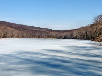
![]()
![]()
![]()
![]()
![]() On Monday, April 8th I wanted to get in a hike close to home and decided to visit Trout Pond. The area around Trout and Mud Ponds is a favorite of mine but I had not been there in some time. I didn't know what to expect as far as trail conditions and the volume of water at the falls. I got myself dressed and had to deal with Sheila who immediately knew we were going hiking. She tends to stick close to make sure I know she wants to go. By the time we left the house at 8:45 AM the temperature was in the low 40's but headed up. We arrived at the parking area at about 9:15 Am and immediately started our hike. Russell Brook Road was mostly clear with a few icy spots in the shade of the evergreen trees. When we reached the viewpoint over the upper falls, I had to stop to take a few shots despite the fact that I have many pictures from the same spot. We walked down to the lower parking area and then headed down to the bridge over Russell Brook. There was now snow or ice but the trail was soft and muddy in places. We walked over to the falls and down the bank to the streambed. I took pictures of the falls and a couple of Sheila in front of the falls before heading back to the main trail. We walked passed the register box and up the wide woods road toward the outlet of Trout Pond. There was still very little snow but there was water and mud. As we approached Trout Pond, I was surprised to see that there was still ice covering most of the pond. The only open area I could see was near the spillway. Sheila immediately ran out onto the ice! I took some pictures of the scenery with the ice on the pond. I began to throw a stick out onto the ice for Sheila to retrieve. As she brought the stick back, I took pictures. We headed back to the main trail and walked up to the inlet end of the pond. As we approached the inlet stream I could hear some ducks take to flight. I knew Sheila would go after them. It seemed that she ran across the open water near shore and onto the ice! We walked to the upper end of the pond and I took some more pictures. I threw a stick into the water and Sheila retrieved it several times. After this we walked to the trail that starts up Cherry Ridge and continued our hike. As we began to ascend, the trail began to be covered in snow and ice with more in the surrounding woods. This area also had a more northerly and westerly exposure. The snow and ice continued to the top of the rise and then dissipated some on the other side. We continued to run into some areas with snow but also walked around some water and mud. Soon we were at the junction with the snowmobile trail that runs passed Mud Pond. We turned left and climbed a little before descending back to the register box. From there we walked back out to the lower parking area and then up the road to the car. The temperature had risen into the 50's. We were back at the car at 11:40 AM having covered 5.6 miles in 2.5 hours.
On Monday, April 8th I wanted to get in a hike close to home and decided to visit Trout Pond. The area around Trout and Mud Ponds is a favorite of mine but I had not been there in some time. I didn't know what to expect as far as trail conditions and the volume of water at the falls. I got myself dressed and had to deal with Sheila who immediately knew we were going hiking. She tends to stick close to make sure I know she wants to go. By the time we left the house at 8:45 AM the temperature was in the low 40's but headed up. We arrived at the parking area at about 9:15 Am and immediately started our hike. Russell Brook Road was mostly clear with a few icy spots in the shade of the evergreen trees. When we reached the viewpoint over the upper falls, I had to stop to take a few shots despite the fact that I have many pictures from the same spot. We walked down to the lower parking area and then headed down to the bridge over Russell Brook. There was now snow or ice but the trail was soft and muddy in places. We walked over to the falls and down the bank to the streambed. I took pictures of the falls and a couple of Sheila in front of the falls before heading back to the main trail. We walked passed the register box and up the wide woods road toward the outlet of Trout Pond. There was still very little snow but there was water and mud. As we approached Trout Pond, I was surprised to see that there was still ice covering most of the pond. The only open area I could see was near the spillway. Sheila immediately ran out onto the ice! I took some pictures of the scenery with the ice on the pond. I began to throw a stick out onto the ice for Sheila to retrieve. As she brought the stick back, I took pictures. We headed back to the main trail and walked up to the inlet end of the pond. As we approached the inlet stream I could hear some ducks take to flight. I knew Sheila would go after them. It seemed that she ran across the open water near shore and onto the ice! We walked to the upper end of the pond and I took some more pictures. I threw a stick into the water and Sheila retrieved it several times. After this we walked to the trail that starts up Cherry Ridge and continued our hike. As we began to ascend, the trail began to be covered in snow and ice with more in the surrounding woods. This area also had a more northerly and westerly exposure. The snow and ice continued to the top of the rise and then dissipated some on the other side. We continued to run into some areas with snow but also walked around some water and mud. Soon we were at the junction with the snowmobile trail that runs passed Mud Pond. We turned left and climbed a little before descending back to the register box. From there we walked back out to the lower parking area and then up the road to the car. The temperature had risen into the 50's. We were back at the car at 11:40 AM having covered 5.6 miles in 2.5 hours.
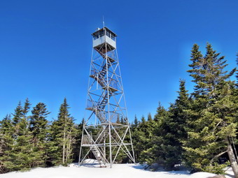
![]()
![]()
![]()
![]()
![]() On Thursday, April 4th I wanted to see some snow before it was all gone as the weather slowly warms. I decided that since I had limited time I would go to Balsam Lake Mountain at the end of the Beaverkill Road. When I left the house at 8:45 AM the temperature was only 27 degrees despite the forecast for highs in the 50's with sunny skies. The drive up the Beaverkill Road was uneventful until just passed the Quill Gordon Lodge. At this point the road became very rough with numerous ruts and bumps. In addition the erosion both side is so extensive that it seems there may soon be no road left. Despite the poor conditions I was able to drive all the way to the end of the road where I found the trailhead parking area open and plowed. I parked and got out to inspect the beginning of the trail. There was wrack a bit of snow on the ground but the trail was packed and would not require snowshoes, at least not at the lower elevations. I decided to carry my snowshoes on my pack and we got on the trail at about 9:35 Am. Almost immediately we ran into a large tree across the trail before the register box. This did not bode well for the rest of the hike. A sign on the register box dated October 26, 2012 warned about "weather" conditions making the trail unsafe. Why was it posted and why hasn't it been taken down almost 6 months after it was put up? The snow and ice continued as we walked the trail with a few bare patches along the way. There was no need for the snowshoes but I considered spikes a couple of time. Several times on the trail we had to climb over or skirt more blowdowns. When we got to the point where the trail turns up the mountain, I could see that the snow on the trail was still well packed and chose not to put on my snowshoes. I considered leaving them behind at this point as the weight on my back was not welcome. In the end I thought that I might need them on the ascent or on the descent of the Millbrook side which always seems to have some deeper snow. As we climbed to the summit, the sun came out and I warmed up considerably. The snow on the trail began to melt a little although, overall, the surface remained firm. The trail had been rerouted in several places to avoid more trees across the path. The postholes along the way were annoying but did make "steps" in several spots. Soon the trail leveled off a little and we were at the junction with the trail to the lean-to. We continued on the main trail and made the steep but short ascent to the spring and then climbed the steps just after it. We were now on the relatively flat summit plateau with only about .4 miles to go to the tower. The half miles section from the lower trail junction to just above the spring gains almost 800 feet and averages a 28% grade.
On Thursday, April 4th I wanted to see some snow before it was all gone as the weather slowly warms. I decided that since I had limited time I would go to Balsam Lake Mountain at the end of the Beaverkill Road. When I left the house at 8:45 AM the temperature was only 27 degrees despite the forecast for highs in the 50's with sunny skies. The drive up the Beaverkill Road was uneventful until just passed the Quill Gordon Lodge. At this point the road became very rough with numerous ruts and bumps. In addition the erosion both side is so extensive that it seems there may soon be no road left. Despite the poor conditions I was able to drive all the way to the end of the road where I found the trailhead parking area open and plowed. I parked and got out to inspect the beginning of the trail. There was wrack a bit of snow on the ground but the trail was packed and would not require snowshoes, at least not at the lower elevations. I decided to carry my snowshoes on my pack and we got on the trail at about 9:35 Am. Almost immediately we ran into a large tree across the trail before the register box. This did not bode well for the rest of the hike. A sign on the register box dated October 26, 2012 warned about "weather" conditions making the trail unsafe. Why was it posted and why hasn't it been taken down almost 6 months after it was put up? The snow and ice continued as we walked the trail with a few bare patches along the way. There was no need for the snowshoes but I considered spikes a couple of time. Several times on the trail we had to climb over or skirt more blowdowns. When we got to the point where the trail turns up the mountain, I could see that the snow on the trail was still well packed and chose not to put on my snowshoes. I considered leaving them behind at this point as the weight on my back was not welcome. In the end I thought that I might need them on the ascent or on the descent of the Millbrook side which always seems to have some deeper snow. As we climbed to the summit, the sun came out and I warmed up considerably. The snow on the trail began to melt a little although, overall, the surface remained firm. The trail had been rerouted in several places to avoid more trees across the path. The postholes along the way were annoying but did make "steps" in several spots. Soon the trail leveled off a little and we were at the junction with the trail to the lean-to. We continued on the main trail and made the steep but short ascent to the spring and then climbed the steps just after it. We were now on the relatively flat summit plateau with only about .4 miles to go to the tower. The half miles section from the lower trail junction to just above the spring gains almost 800 feet and averages a 28% grade.
The snow on the top was deeper but the trail was still packed. There was some new powder on top of the older snow and it was just enough to fill in and masked some of the postholes! We arrived at the tower at 10:50 AM after hiking 1.7 miles and gaining 1230 feet. The skies were bright and sunny but almost cloudless. The day before the wind had been gusting to 30 mph but on this day there was hardly a breeze! I took a few shots of the tower after dumping my pack and heading over to the tower. Sheila was happily running around and around the summit taking few minutes now and then to follow an animal track. I climbed to just below the cab and took pictures in all direction. It was so clear I could see for miles but the lack of clouds made the sky look "flat". After taking pictures, I returned to the ground and decided to return by descending the Millbrook side to complete a loop. I also decided to wear the snowshoes Mon my feet instead of on my back. As we started down the trail, it was immediately obvious that there was more snow on this side of the mountain. I also noticed some older cross country ski tracks. As we continued on and the trail got steeper, the snow also got deeper. In places the drifts were almost two feet deep and the snow was powdery. It was fun to "ski" down the trail and we made good time. As we neared the bottom of the trail and the gate, we both heard voices ahead. I had forgotten Sheila's leash so I kept her close to me. We got to the gate, we found Tom and Laurie and two other hikers. They were transporting boards to the fire tower by carrying them and dragging them on a "sled". We talked for a few minutes about fire towers before it was time to go our separate ways. We continued down to the trail unction and turned right to head back to the car. This part of the trail had a little less snow as it is exposed more to the sun. Sheila was busy following game trails up the bank and down toward the stream below. At the trail junction I decided to leave the snowshoes on my feet even though I knew I did not need them. Getting over and around the blowdowns was more difficult with snowshoes but soon we were back at the parking area. We had hiked 4.3 miles in 2 hours and 45 minutes including 1240 feet of elevation gain. When I looked at the thermometer in the car, the temperature was 51 degrees!
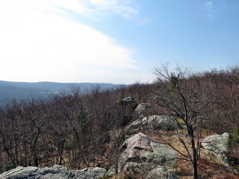
![]()
![]()
![]()
![]()
![]() On Monday, April 1st I was ready to get out after taking a break for the end of Holy Week. I had been thinking about returning to Fitzgerald Falls near Greenwood Lake and hiking at least 8 miles. I had already hiked from Lakes Road to Little Dam Lake and was looking for a somewhat different hike. I decided to park at the top of Mt. Peter on Route 17A and hike the AT to Fitzgerald Falls. This would allow me to walk a section of the AT that I had not been on before and take a different approach to the falls. I knew this would mean a decent on the way out with an ascent on the return trip but that was OK with me. The forecast was for afternoon showers so I wanted to get done before I got wet. As is often the case, my resolve to start early got sidetracked and we didn't arrive at the trailhead until 10:20 AM. As I parked I was surprised to see that the run down buildings by the side of the road had been completely removed! We got ready to hike and I put Sheila on her leash to cross the busy highway. Once on the other side I released her and we started to hike along northeast the ridge. Just after crossing the road a blue trail turned to the left hike the AT turned right. A glance at the map did not reveal the name or route of the blue trail although I suspected it went to Mt. Peter. The walk along the ridge was along a wide and almost flat trail. At about 1.3 miles the Highland Trail turned off to the left while the AT continued up and over some rocks to a nice viewpoint. The lookout was not as expansive as the one to the south on Bellvale Ridge but I got out my camera to take a few pictures. After taking two pictures, the camera shut down because I had not recharged the battery! This is the second time I have done this recently but the last time it occurred at the end of the hike! The people who blazed the AT must have had an interesting outlook since they placed the blazes on a knife edge of rock that descended back to the trail. I could only think how dangerous this would be if it was icy or wet. We did see a little bit of ice under a rock but that was all we would see for the rest of the hike. The temperature was 50 degrees and I was glad I had eschewed a baselayer. Along the trail there were several ponds which were full of various frogs and toads making a cacophony of sound. Sheila did not know what to make of the racket and cautiously moved by these areas.
On Monday, April 1st I was ready to get out after taking a break for the end of Holy Week. I had been thinking about returning to Fitzgerald Falls near Greenwood Lake and hiking at least 8 miles. I had already hiked from Lakes Road to Little Dam Lake and was looking for a somewhat different hike. I decided to park at the top of Mt. Peter on Route 17A and hike the AT to Fitzgerald Falls. This would allow me to walk a section of the AT that I had not been on before and take a different approach to the falls. I knew this would mean a decent on the way out with an ascent on the return trip but that was OK with me. The forecast was for afternoon showers so I wanted to get done before I got wet. As is often the case, my resolve to start early got sidetracked and we didn't arrive at the trailhead until 10:20 AM. As I parked I was surprised to see that the run down buildings by the side of the road had been completely removed! We got ready to hike and I put Sheila on her leash to cross the busy highway. Once on the other side I released her and we started to hike along northeast the ridge. Just after crossing the road a blue trail turned to the left hike the AT turned right. A glance at the map did not reveal the name or route of the blue trail although I suspected it went to Mt. Peter. The walk along the ridge was along a wide and almost flat trail. At about 1.3 miles the Highland Trail turned off to the left while the AT continued up and over some rocks to a nice viewpoint. The lookout was not as expansive as the one to the south on Bellvale Ridge but I got out my camera to take a few pictures. After taking two pictures, the camera shut down because I had not recharged the battery! This is the second time I have done this recently but the last time it occurred at the end of the hike! The people who blazed the AT must have had an interesting outlook since they placed the blazes on a knife edge of rock that descended back to the trail. I could only think how dangerous this would be if it was icy or wet. We did see a little bit of ice under a rock but that was all we would see for the rest of the hike. The temperature was 50 degrees and I was glad I had eschewed a baselayer. Along the trail there were several ponds which were full of various frogs and toads making a cacophony of sound. Sheila did not know what to make of the racket and cautiously moved by these areas.
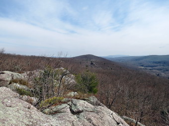 At 1.7 miles the Highlands Trail headed right and the AT again went up and over a high rock outcrop. This was another spot that I knew would be almost impassable when the rock was wet or icy. There wasn't much of a view from the rocks and I had a tough time getting Sheila to negotiate over one particular spot. Once we were down off the rocks the trail was again mostly flat and easy to walk. As we walked, I noticed a shelter on the left side of the trail with a spur trail running to it. At 2.9 miles the AT turned right and started to descend the ridge while the Highlands Trail continued straight ahead. The descent wasn't too steep and was made easier by several switchbacks. As we neared Lakes Road, the AT blazes disappeared and the trail was hard to follow. The problem in this case was several large trees that were blown down and blocking the trail. There had been quite a few of these along the way with some having paths around them and some not. I wondered who has the responsibility of clearing the AT! We crossed Lakes Road where there was only one car parked and continued on the AT on the other side. We had dropped almost 600 feet from the highest point on the ridge. We crossed Trout Creek on the wooden bridge and walked another .4 miles to Fitzgerald Falls. It was 12:10 PM and we had hiked about 3.9 miles. I was able to squeeze one more picture out of my camera. The falls were nice but could have used a little more water volume. It was still sunny and I was feeling pretty good so I decided to continue on for a little while. I thought we might turn around at the top of the ridge where the AT and the Highlands Trail split. As we walked along, we met a young man hiking towards us. He asked how far it was to the Wildcat Shelter and I told him it was less than 3 miles. After walking some distance, mostly uphill, I lost the AT blazes at about 5 miles. The skies were darkening and for the first time on the hike I remembered the forecast for showers. We bushwhacked up the ridge looking for the AT blazes and headed a little more east and south. I caught a glimpse of two hikers coming up the hill and asked them if they had AT blazes. They said that they did and I we walked over to the trail and up to the trail junction on the ridge. I talked to the other hikers briefly while Sheila eyed their dog. It was 1:00 PM and since the skies were growing much darker, Sheila and I turned around and headed back having about 5.25 miles to cover!
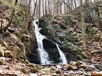 We made our way toward the falls at a quickened pace. By the time we got to the falls the raindrops were falling. We continued on and crossed the road where there were now at least five cars parked. Next, we had to climb back up to the ridge which I thought would be hard but was fairly easy. The rain began to fall a little harder but then let up. This pattern repeated itself until we got to the car. Once we were on the ridge the hike went quickly except for the rain. Just before the second big rock outcropping we her some "joyous" voice ahead that sounded like teenage boys enjoying the rain. I chose to avoid walking up the slippery rock outcrop and used the Highlands Trail to bypass the rocks. At the first rock outcrop the boys chose to go up and over and I chose to bushwhack around the slippery rocks eventually finding the Highlands Trail which shortly joined the AT. I picked up the pace to stay ahead of the boys and Sheila and I made good time. Within a mile of the end of the hike the rain abated and I saw another hiker coming toward us. I slowed to let him catch up and we struck up a conversation. He was an EMT at Mt. Peter and since his job was ending for the season, he had plans to hike the AT starting from Georgia on May 1st. We talked about his job and his hiking plans until we got to the trail junction. He continued on to Mt. Peter and we went back to the car. I didn't think I was that wet until I took off my pack at the car and found it soaked. Sheila also was pretty wet but she didn't seem to mind. We had covered 10.1 miles in 4 hours and 45 minutes. I thought about returning on a clearer day when my camera battery was fully charged.
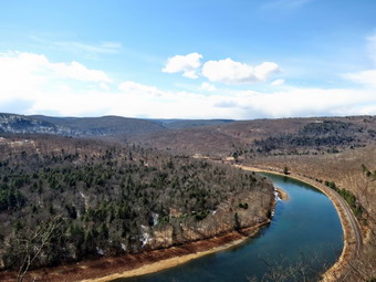
![]()
![]()
![]()
![]()
![]() On Wednesday, March 27th Lisa Lyons and I decided we wanted to get out on a hike and she suggested AT to Fitzgerald Falls in Lordville near French Woods. I had track practice until noon so we agreed to meet at her store just before 1:00 PM. I had voiced my concern that the road to the trailhead might be very wet and muddy but we decided to try it anyway. We discussed hiking in from Long Eddy but we were not sure of the route and decided to go from Lordville. As I drove up the Quickway to Hancock, the weather changed from sunny with puffy white clouds in a blue sky to overcast and ominous. To the west we could see a snow squall covering the landscape. I was discourages since I had hoped for the bright blue skies but decided the hike was well worth it no matter the sky or weather conditions. In Hancock I followed the signs for Route 97 south toward French Woods. Just before French Woods, I turned right on Lordville Road and drove down to the Delaware River and turned left on Bouchouxville Road. The road's condition had not improved any since I was on it last but it was drier than I expected. A slow and careful drive allowed us to arrive at the trailhead unscathed and we were ready to hike by 1:50 PM. The temperature was in the 40's and the sun was out but it seemed a little colder as a breeze was blowing. We had not brought snowshoes and would not need them as there was little or no snow in sight. We headed up the wide woods road under sunny skies with Sheila happily dashing back and forth. The trail is rocky and a little eroded in places and we found several blowdowns on or near the trail. I had forgotten that although the hike is short it does gain some elevation. In the short .75 miles to the ledges the trail goes from 900 feet to over 1400 feet in elevation gaining over 525 feet in the process. As we neared the end of the climb, the wind picked up and we could see a snow squall moving our way from across the river. Lisa stopped to don a jacket to replace her vest and in that short time the squall hit. Snow was falling and the wind blowing but the sun could be seen peeking through the clouds. I was hoping the squall would pass so that we could take pictures from the ledges. We finished the climb to the ledges, crossed the brook and were soon on the first of the two lookouts. It was around 2:25 PM.
On Wednesday, March 27th Lisa Lyons and I decided we wanted to get out on a hike and she suggested AT to Fitzgerald Falls in Lordville near French Woods. I had track practice until noon so we agreed to meet at her store just before 1:00 PM. I had voiced my concern that the road to the trailhead might be very wet and muddy but we decided to try it anyway. We discussed hiking in from Long Eddy but we were not sure of the route and decided to go from Lordville. As I drove up the Quickway to Hancock, the weather changed from sunny with puffy white clouds in a blue sky to overcast and ominous. To the west we could see a snow squall covering the landscape. I was discourages since I had hoped for the bright blue skies but decided the hike was well worth it no matter the sky or weather conditions. In Hancock I followed the signs for Route 97 south toward French Woods. Just before French Woods, I turned right on Lordville Road and drove down to the Delaware River and turned left on Bouchouxville Road. The road's condition had not improved any since I was on it last but it was drier than I expected. A slow and careful drive allowed us to arrive at the trailhead unscathed and we were ready to hike by 1:50 PM. The temperature was in the 40's and the sun was out but it seemed a little colder as a breeze was blowing. We had not brought snowshoes and would not need them as there was little or no snow in sight. We headed up the wide woods road under sunny skies with Sheila happily dashing back and forth. The trail is rocky and a little eroded in places and we found several blowdowns on or near the trail. I had forgotten that although the hike is short it does gain some elevation. In the short .75 miles to the ledges the trail goes from 900 feet to over 1400 feet in elevation gaining over 525 feet in the process. As we neared the end of the climb, the wind picked up and we could see a snow squall moving our way from across the river. Lisa stopped to don a jacket to replace her vest and in that short time the squall hit. Snow was falling and the wind blowing but the sun could be seen peeking through the clouds. I was hoping the squall would pass so that we could take pictures from the ledges. We finished the climb to the ledges, crossed the brook and were soon on the first of the two lookouts. It was around 2:25 PM.
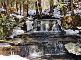 As we approached the stream, the bare trail gave way to several inches of snow on the ground. It was a dramatic change and we both commented on it. The snow was still falling and visibility was limited at the ledges. I took some pictures of the landscape through the squall and also snapped some shots of the cairn and stone furniture on the ledges. The squall seemed to be letting up so I walked over to the other lookout to take in the view from there. There was another blowdown on the way to the second lookout but it was easily bypassed. I dropped my pack and got out my camera as the skies started to clear. The second lookout is better than the first and I took a lot of pictures both up and down the river. By the time I was through shooting the squall was completely ended and the sun was out again. Sheila is a little scary around the ledges as she will walk up right to the edge to get the best view! We walked back to the first lookout to get Lisa and started back to the parking area. We had talked about hiking through to the Long Eddy end of the trail but neither of us seemed to feel this was the day. When we crossed the stream we both decided it would be nice to check out the waterfall on the small stream we had just crossed. the stream flows into the Delaware by cascading from over 1400 feet to the river at under 900 feet below. We stopped to take some pictures and we were both mesmerized by the sun striking the water as it began its journey. I wanted to descend to a lower vantage point but decided the icy on the rocks made this a poor choice! I leashed Sheila to a branch so that she would not get too close to the icy edge of the rocks. When we were done, we headed back to the main trail and started down the trail. Sheila was still full of energy and was picking up sticks which were really large tree branches. We were back at the car by 3:30 PM having covered 2.1 miles and climbing over 600 feet in 1 and 45 minutes. Forty-five minutes of our time was used for photography! We decided to come back through Tennanah Lake and Roscoe which proved to be about the same distance as the other routes we had used.
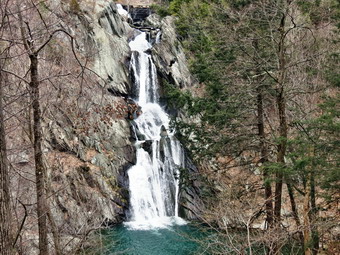
![]()
![]()
![]()
![]()
![]() On Tuesday, March 26th I left Beebe Hill State Forest near Austerlitz and headed west and south toward Philmont. After crossing the Taconic State Parkway I picked up Route 217 which went through the middle of Philmont. The car GPS could not find the address of the High Falls park on Roxbury Road but as I drove through the town the road was on the right after descending a small hill. The parking area was on the left side of Roxbury Road just a few hundred feet uphill from the turn. I parked that car and, once again, we were the only car in the lot. We had not seen another person all day! I had looked at the map of the area on the internet and there was a map at the information kiosk just at the start of the trails. We started down the trail at 2:45 PM and wherever there was a split we stayed on the green trail. These trails were muddy but almost flat. After less than half a mile we were at the lookout for the falls. The lookout was cut out and there was a clear view of the falls directly across from the viewpoint. The falls are supposed to be 150 feet high but I thought that was a slight exaggeration. I took many different pictures of the falls before deciding that we needed to start for home. I had noticed another falls to the right of the main falls on our way out. I tried looking for a viewpoint from the green trail and a little off the trail but could not find one. I looked down tat he creek bed and noticed a trail and a bench. Knowing there had to be an "official" way to get there and get back, I decided to simply walk down the steep bank to the trail. After a little slipping and sliding we were on the lower trail. We walked along the trail until we were directly across from the smaller falls and I took some nice shots before walking back along the creek until I found the trail that led back up to the green trail. We took the green trail back to the car after hiking 1.2 miles in 40 minutes. Now it was time to head home. The total mileage for the day was about 300 miles, only 6 of which were hiking!
On Tuesday, March 26th I left Beebe Hill State Forest near Austerlitz and headed west and south toward Philmont. After crossing the Taconic State Parkway I picked up Route 217 which went through the middle of Philmont. The car GPS could not find the address of the High Falls park on Roxbury Road but as I drove through the town the road was on the right after descending a small hill. The parking area was on the left side of Roxbury Road just a few hundred feet uphill from the turn. I parked that car and, once again, we were the only car in the lot. We had not seen another person all day! I had looked at the map of the area on the internet and there was a map at the information kiosk just at the start of the trails. We started down the trail at 2:45 PM and wherever there was a split we stayed on the green trail. These trails were muddy but almost flat. After less than half a mile we were at the lookout for the falls. The lookout was cut out and there was a clear view of the falls directly across from the viewpoint. The falls are supposed to be 150 feet high but I thought that was a slight exaggeration. I took many different pictures of the falls before deciding that we needed to start for home. I had noticed another falls to the right of the main falls on our way out. I tried looking for a viewpoint from the green trail and a little off the trail but could not find one. I looked down tat he creek bed and noticed a trail and a bench. Knowing there had to be an "official" way to get there and get back, I decided to simply walk down the steep bank to the trail. After a little slipping and sliding we were on the lower trail. We walked along the trail until we were directly across from the smaller falls and I took some nice shots before walking back along the creek until I found the trail that led back up to the green trail. We took the green trail back to the car after hiking 1.2 miles in 40 minutes. Now it was time to head home. The total mileage for the day was about 300 miles, only 6 of which were hiking!
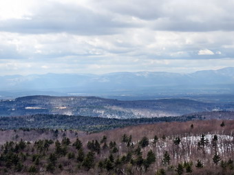
![]()
![]()
![]()
![]()
![]() On Tuesday, March 26th I left Grafton Lake State Park at noon and headed east to Petersburg in quest of the second objective of the day, the Beebe Hill Fire Tower in Beebe Hill State Forest. From Petersburg it was a straight shot down Route 22 to Austerlitz, the site of Beebe Hill State Forest. I passed through many small towns with interesting stores and historical sites. As I approached my destination, I was a little unclear about exactly where to go. I turned north of Osmer Road from Route 22 knowing I was looking for Barrett Pond and a small parking area. I passed a pond but did not see any place to park. After another pond did not appear, I doubled back and found a road just north of the pond off Osmer Road. The access road was deeply rutted with a lot of snow on the surface but I made it into the small parking area. As we got out of the car at 1:25 PM, I was greeted by a sign that said "Fire Tower 1 mile". I had the choice of taking the road to the tower or using the trail. By looking at the map I determined the trail was more direct so Sheila and I started out on the trail. The trail immediately crossed a brook on a small bridge and started up a ridge. The climb looked pretty steep but the trail switched back and forth several times which made the ascent easy. The footing was getting a little slippery as the snow melted. It was obvious that the trail had seen some recent traffic also. Within about .5 miles we had done most of the climbing and the trail flattened out. We passed a lean-to with a privy and then continued to walk toward the tower. Soon the tower appeared with a direct path to it and the trail which headed toward some other buildings. I continued on the trail and found an observers cabin and another storage building at the top not far from the tower. It was 1:45 PM and the hike up had only been .85 miles. The skies now had some sun and were blue with a few wispy clouds. The cab on this tower was in about the state as the one on Dickinson Hill. The cab was open for viewing but there was no glass to protect the viewer. The wind was blowing but it did not seem very cold. I again took many pictures with the best view being to the east. It was getting late and Sheila seemed anxious that I was up in the tower so I descended and we made our way back to the car. It was 2:15 PM and we had hiked 1.7 miles in 50 minutes with a 10 minute stop. I was ready to start toward home but had one more stop to make in Philmont at High Falls.
On Tuesday, March 26th I left Grafton Lake State Park at noon and headed east to Petersburg in quest of the second objective of the day, the Beebe Hill Fire Tower in Beebe Hill State Forest. From Petersburg it was a straight shot down Route 22 to Austerlitz, the site of Beebe Hill State Forest. I passed through many small towns with interesting stores and historical sites. As I approached my destination, I was a little unclear about exactly where to go. I turned north of Osmer Road from Route 22 knowing I was looking for Barrett Pond and a small parking area. I passed a pond but did not see any place to park. After another pond did not appear, I doubled back and found a road just north of the pond off Osmer Road. The access road was deeply rutted with a lot of snow on the surface but I made it into the small parking area. As we got out of the car at 1:25 PM, I was greeted by a sign that said "Fire Tower 1 mile". I had the choice of taking the road to the tower or using the trail. By looking at the map I determined the trail was more direct so Sheila and I started out on the trail. The trail immediately crossed a brook on a small bridge and started up a ridge. The climb looked pretty steep but the trail switched back and forth several times which made the ascent easy. The footing was getting a little slippery as the snow melted. It was obvious that the trail had seen some recent traffic also. Within about .5 miles we had done most of the climbing and the trail flattened out. We passed a lean-to with a privy and then continued to walk toward the tower. Soon the tower appeared with a direct path to it and the trail which headed toward some other buildings. I continued on the trail and found an observers cabin and another storage building at the top not far from the tower. It was 1:45 PM and the hike up had only been .85 miles. The skies now had some sun and were blue with a few wispy clouds. The cab on this tower was in about the state as the one on Dickinson Hill. The cab was open for viewing but there was no glass to protect the viewer. The wind was blowing but it did not seem very cold. I again took many pictures with the best view being to the east. It was getting late and Sheila seemed anxious that I was up in the tower so I descended and we made our way back to the car. It was 2:15 PM and we had hiked 1.7 miles in 50 minutes with a 10 minute stop. I was ready to start toward home but had one more stop to make in Philmont at High Falls.
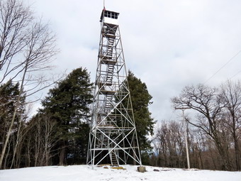
![]()
![]()
![]()
![]()
![]() On Tuesday, March 26th I had planned to visit two fire towers and a waterfalls near in the Albany/Troy area. I was going to go there on Monday but the forecast was for snow and overcast skies. I wanted to get some good pictures of the towers and some shots from the top of the towers. The forecast for Tuesday was for some sun and partly cloudy skies so I decided to postpone the trip until then. I wanted to leave at 7:00 Am but did not get out of the house until around 7:30 AM. I had directions from Google Maps and the Garmin car GPS to guide me. This time I also wrote down the latitude and longitude of the locations. I drove to Liberty and then headed to Kingston through Ellenville. At some point I realized I had forgotten Sheila's leash again so I stopped in Kingston to pick up another. From Kingston I took the Thruway north and headed for Troy. The prediction of partly sunny skies seemed to have been in error as there was a complete overcast with intermittent snow and rain. I was discouraged but knew I had some distance to go. I got off the Quickway on Route 787 and drove to Troy where I picked up Route 7 to Route 2. Soon I was in the area of Grafton Lake State Park where I found the "Winter Entrance" open. I drove into the park and passed the park office to find North Long Pond Road only partially plowed. I went back to the office to get directions. A very helpful woman at the office told me where to park and discussed trail conditions with me. I drove to along North Long Pond Road which was plowed on one side with a generous lane for snowmobiles on the other. Until I turned into the park there seemed to be almost no snow but now there was plenty. I drove passed the sign for the fire tower on the right and parked in the next lot. It was 10:45 AM and the trip was a little longer than I thought!
On Tuesday, March 26th I had planned to visit two fire towers and a waterfalls near in the Albany/Troy area. I was going to go there on Monday but the forecast was for snow and overcast skies. I wanted to get some good pictures of the towers and some shots from the top of the towers. The forecast for Tuesday was for some sun and partly cloudy skies so I decided to postpone the trip until then. I wanted to leave at 7:00 Am but did not get out of the house until around 7:30 AM. I had directions from Google Maps and the Garmin car GPS to guide me. This time I also wrote down the latitude and longitude of the locations. I drove to Liberty and then headed to Kingston through Ellenville. At some point I realized I had forgotten Sheila's leash again so I stopped in Kingston to pick up another. From Kingston I took the Thruway north and headed for Troy. The prediction of partly sunny skies seemed to have been in error as there was a complete overcast with intermittent snow and rain. I was discouraged but knew I had some distance to go. I got off the Quickway on Route 787 and drove to Troy where I picked up Route 7 to Route 2. Soon I was in the area of Grafton Lake State Park where I found the "Winter Entrance" open. I drove into the park and passed the park office to find North Long Pond Road only partially plowed. I went back to the office to get directions. A very helpful woman at the office told me where to park and discussed trail conditions with me. I drove to along North Long Pond Road which was plowed on one side with a generous lane for snowmobiles on the other. Until I turned into the park there seemed to be almost no snow but now there was plenty. I drove passed the sign for the fire tower on the right and parked in the next lot. It was 10:45 AM and the trip was a little longer than I thought!
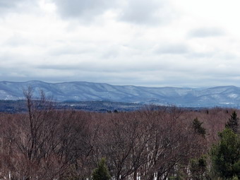 Since there seemed to be quite a bit of snow in the parking lot, I decided to change into my winter boots and wear my snowshoes. After getting my gear on Sheila and I walked back up the road to the fire tower sign and turned left on the trail. This trail had been hard packed by snowmobiles which made snowshoes unnecessary. I noticed some boot prints as I walked along and saw that they had hard made an impression on the trail. I knew I could continue to use the snowshoes, take them back to the car or ditch them under a bush. In the end I decided on the latter and took off the shows and hid them under the snow behind a tree. We continued to walk on the trail which, although not clearly marked, was unmistakable. There were several spur trails but we continued on the main trail toward the tower. The trail went up and down a little but no grade was steeper than 10%. At about 1.3 miles from the car the trail ended at Fire Tower Road which approaches the tower from the other side. There is no parking on this road which was made clear by a number of signs so the best access is from the state park. There is a private residence at the very end of Fire Tower Road but we walked by it on the road without a problem. After about 500 feet on the Fire Tower Road the gate to the fire tower appeared on the right. We turned at walked to the top of Dickinson Hill where the fire tower is located. By now the skies were a little bluer and there was some sun. I took a few pictures of the tower and then climb to the top. I was surprised that the cab was open but had no windows! The tower is "billed" as restored but could use a little more work. The views to the east were unobstructed but not very interesting. To the southwest there were great views of the Catskills but a communications tower on the same hill as the fire tower marred the spectacular scene. I took many pictures in all directions and tried to avoid including the tower in any of them. When I was done, I descended the tower and we retraced our route back to the car. I was happy that my snowshoes were right where I left them! It was noon when we finished and we had covered 3 miles in 1.25 hours with about 15 minutes to take pictures. I drove out to Route 2 and then turned east towards Petersburg.
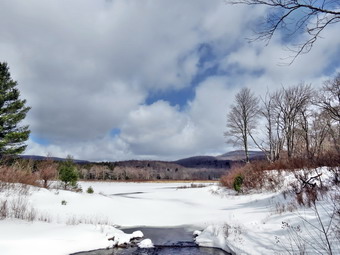
![]()
![]()
![]()
![]()
![]() On Saturday, March 23rd I decided to get out for the first hike of the spring season. My wife was suffering from the flu and I was starting to feel like I might be the next victim. A number of commitments during the week had kept me out of the woods. Sheila in particular was anxious to get out and had been begging for a day out over the last few days. After a few morning chores, I got my gear ready to go and put Sheila in the back seat. Although the temperature was in the low 30's the persistent breeze made it feel cooler and I had donned a baselayer and my Salomon B-52 winter boots. I wasn't sure whether or not I would need snowshoes but I put them in the trunk just in case. When I turned onto Beech Mountain Road, I was surprised that there was a good layer of snow on the road. I parked at the Frick Pond lot and let the dog out of the car. Sheila could not contain herself as she exploded out of the car and ran around sniffing everything. The stiff breeze made me glad I had put on baselayer. The 6 inches of snow at the parking area made me glad I had brought the snowshoes. I knew that snow in the parking area meant more snow on the Flynn Trail near Hodge Pond. We were on the trail and hiking by 11:40 AM and I was surprised to find that we were the first people to hike since the last snowfall! I stopped at the register to take a few pictures of the trail with the unbroken snow and blue skies. We walked down to outlet of Frick Pond and stopped again. I took some pictures even though I taken MANY pictures here before. The pond was still covered in ice except in the area near the bridge. The skies were blue but starting to cloud over as I took some pictures of Flynn's Point. We walked across the bridge and stayed left at the trail junction to head toward Iron Wheel Junction on the Quick Lake Trail. There was still quite a bit of snow on the ground even under the trees as we crossed the small brook. At 12:30 PM we were at Iron Wheel Junction and we turned left to stay on the Quick Lake Trail and head toward the Flynn Trail at Junkyard Junction.
On Saturday, March 23rd I decided to get out for the first hike of the spring season. My wife was suffering from the flu and I was starting to feel like I might be the next victim. A number of commitments during the week had kept me out of the woods. Sheila in particular was anxious to get out and had been begging for a day out over the last few days. After a few morning chores, I got my gear ready to go and put Sheila in the back seat. Although the temperature was in the low 30's the persistent breeze made it feel cooler and I had donned a baselayer and my Salomon B-52 winter boots. I wasn't sure whether or not I would need snowshoes but I put them in the trunk just in case. When I turned onto Beech Mountain Road, I was surprised that there was a good layer of snow on the road. I parked at the Frick Pond lot and let the dog out of the car. Sheila could not contain herself as she exploded out of the car and ran around sniffing everything. The stiff breeze made me glad I had put on baselayer. The 6 inches of snow at the parking area made me glad I had brought the snowshoes. I knew that snow in the parking area meant more snow on the Flynn Trail near Hodge Pond. We were on the trail and hiking by 11:40 AM and I was surprised to find that we were the first people to hike since the last snowfall! I stopped at the register to take a few pictures of the trail with the unbroken snow and blue skies. We walked down to outlet of Frick Pond and stopped again. I took some pictures even though I taken MANY pictures here before. The pond was still covered in ice except in the area near the bridge. The skies were blue but starting to cloud over as I took some pictures of Flynn's Point. We walked across the bridge and stayed left at the trail junction to head toward Iron Wheel Junction on the Quick Lake Trail. There was still quite a bit of snow on the ground even under the trees as we crossed the small brook. At 12:30 PM we were at Iron Wheel Junction and we turned left to stay on the Quick Lake Trail and head toward the Flynn Trail at Junkyard Junction.
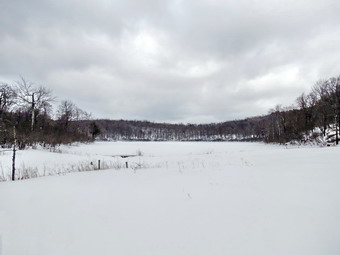 When we turned at Iron Wheel Junction, I was a little surprised to find that snowmobiles had recently been over the trail. This meant that walking was much easier on the packed snow. A little further up the trail the fresh snowmobile tracks turned left toward Quick Lake. There were older snowmobile tracks on the Quick Lake Trail which continued all the way to Junkyard Junction. The temperature was on the rise as we hit Junkyard Junction and turned onto the Flynn Trail with its unbroken snow. The snow was deeper on this trail and it had changed from the lighter powder to a heavier consistency. I had not been out on snowshoes in some time and was beginning to tire some from the exertion. As we hiked along the Flynn Trail in the heavier snow, The muscles on the insides of both thighs were becoming sore. Fortunately The Flynn Trail is almost flat which the going a little easier. At the gate we followed the Flynn Trail down to Hodge Pond. Several large blowdowns in this area still have not been cleared and make hiking this short section difficult. When we got to the pond, I decided to turn right and head around the front of the pond since my legs were not feeling any fresher. We stopped at the outlet to Hodge Pond at 1:45 PM and I took a few pictures. By this time the clouds had really rolled in and the sky was completely overcast with a blustery wind. This was a stark contrast to the blue skies we had seen earlier at Frick Pond. After I took a few shots, we turned and continued on the Flynn Trail up the hill to the junction with the Big Rock Trail. Ascending the hill convinced me I was done for the day as my thighs screamed "Enough!" I expected the trip down the Flynn Trail to the parking area to be easier but I was wrong. The snow was now very heavy and was sticking to the bottom of the snowshoes and collecting on top of the deck. Each time I raised a foot I was lifting at least twice the weight of the snowshoe! Sheila wasn't helping and as she roamed following any game trail she could find! The 1.7 miles to the parking area seemed longer than usual. When the gate finally came in sight, I decided to carry the snowshoes which seemed like a good idea. After I removed the snowshoes, walking did seem to be easier but I was sinking further into the snow than I had anticipated. I concluded that although the snowshoes might not have been mandatory they probably did help overall. We were back at the car by 3:00 PM having covered 6.4 miles in 3 hours and 20 minutes.