
What You Missed
Fall 2006
Fall 2006
![]()
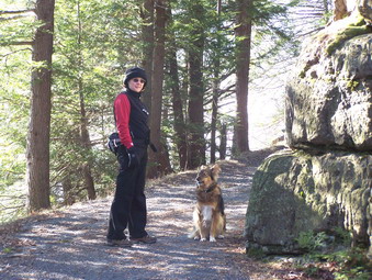
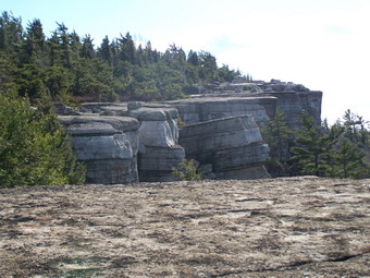
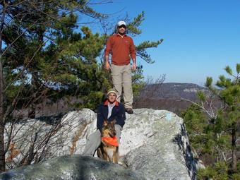
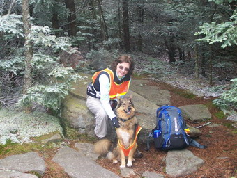
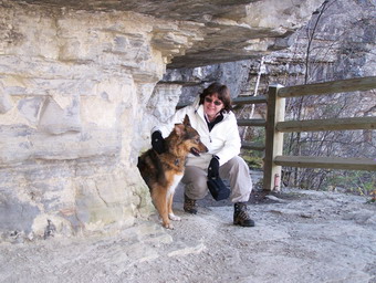
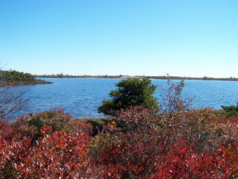
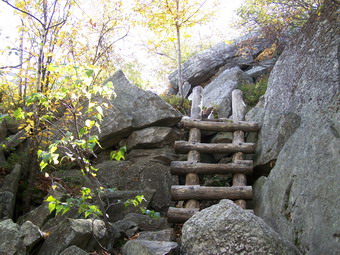
![]() On Saturday, December 9th my wife, and Sheba and I went back to the
Shawangunks and Minnewaska State Park to hike. I had read several books about the many trails and the history of
the area. It seemed that Castle Point and Hamilton Point were worth the visit. The round trip distance seemed to
be about 9 miles but most of it is on wide carriageways that allow quick hiking. The view of lake Awosting from
some of the lookouts along the way also intrigued me. The day started cool and clear with some wind blowing near
the lake. We were well dressed and struck out immediately knowing that the paths offered some protection
from the wind. We started at the Lake Minnewaska parking area and bore to the right around the lake. After passing
the turn to the Upper Awosting Carriageway, we picked up the blue blazed Castle Point Carriageway which is well
marked with signs.
On Saturday, December 9th my wife, and Sheba and I went back to the
Shawangunks and Minnewaska State Park to hike. I had read several books about the many trails and the history of
the area. It seemed that Castle Point and Hamilton Point were worth the visit. The round trip distance seemed to
be about 9 miles but most of it is on wide carriageways that allow quick hiking. The view of lake Awosting from
some of the lookouts along the way also intrigued me. The day started cool and clear with some wind blowing near
the lake. We were well dressed and struck out immediately knowing that the paths offered some protection
from the wind. We started at the Lake Minnewaska parking area and bore to the right around the lake. After passing
the turn to the Upper Awosting Carriageway, we picked up the blue blazed Castle Point Carriageway which is well
marked with signs.
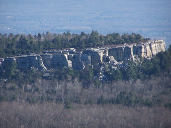
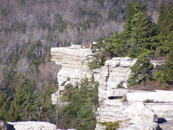
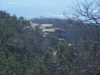 After a short distance, views to the right became available and continue for almost the entire way to castle Point.
Patterson's Pellet comes into view as well as the trail to Gertrude's Nose. The dropoffs are dramatic and
straight down in most cases. We exercised caution but got some great views along the way. The views along the trail
are NOTHING compared to the views from Castle Point. As you approach the Point, it is obvious that you are ascending
to a lookout and the suspense is everything it should be. Along the Point the aqua blazes of the Long Path seem to
come straight up the cliffs to meet the carriageway. In fact, there are a series of steps and handholds which make
the ascent possible but exciting. We left this for another day and continued on to Battlement Terrace.
After a short distance, views to the right became available and continue for almost the entire way to castle Point.
Patterson's Pellet comes into view as well as the trail to Gertrude's Nose. The dropoffs are dramatic and
straight down in most cases. We exercised caution but got some great views along the way. The views along the trail
are NOTHING compared to the views from Castle Point. As you approach the Point, it is obvious that you are ascending
to a lookout and the suspense is everything it should be. Along the Point the aqua blazes of the Long Path seem to
come straight up the cliffs to meet the carriageway. In fact, there are a series of steps and handholds which make
the ascent possible but exciting. We left this for another day and continued on to Battlement Terrace.
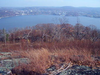
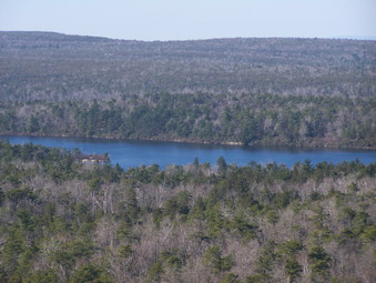 This is another fine lookout which affords a fantastic view of Lake Awosting. The lake looks very close from here
but also very large. It is the highest lake except for Maratanza at Sam's Point. The lake is bout 1.5 miles long
which makes walking around it a journey of over three miles. I filed this thought away for another hike on another
day. We descending under the Terrace where we met the Hamilton Point Carriageway and the where the Long Path leaves
to descend on its own through the woods. We turned right on the carriageway and walked less than half a mile to
an unmarked trail to the left.
This is another fine lookout which affords a fantastic view of Lake Awosting. The lake looks very close from here
but also very large. It is the highest lake except for Maratanza at Sam's Point. The lake is bout 1.5 miles long
which makes walking around it a journey of over three miles. I filed this thought away for another hike on another
day. We descending under the Terrace where we met the Hamilton Point Carriageway and the where the Long Path leaves
to descend on its own through the woods. We turned right on the carriageway and walked less than half a mile to
an unmarked trail to the left.
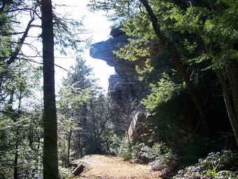 Our intention was to was to follow this trail down to the Wolf's Jaw where large slabs of rock hang over the
trail giving the formation its name. As we approached the Wolf's Jaw, Sheba was ahead of us. She was staring intently
into the gully off the side of the trail. I saw an animal descend a tree and go passed her. My wife is
convinced it was a bear cub and I was not sure what I saw. We decided to hurry passed without investigating. The trail
ends at the Long Path where we turned right to ascend back to the Hamilton point carriageway.
Our intention was to was to follow this trail down to the Wolf's Jaw where large slabs of rock hang over the
trail giving the formation its name. As we approached the Wolf's Jaw, Sheba was ahead of us. She was staring intently
into the gully off the side of the trail. I saw an animal descend a tree and go passed her. My wife is
convinced it was a bear cub and I was not sure what I saw. We decided to hurry passed without investigating. The trail
ends at the Long Path where we turned right to ascend back to the Hamilton point carriageway.
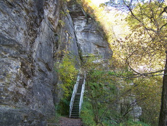
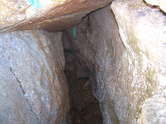 On the ascent we came to The Tunnel. This is an area where slabs of rock have separated from the main body. Other
slabs have fallen into the cracks and formed a sort of tunnel. It is short but tight and I though I might have to
remove my pack. We all made it through this area and another low overhand beyond and continued up to the Hamilton
Point Carriageway.
On the ascent we came to The Tunnel. This is an area where slabs of rock have separated from the main body. Other
slabs have fallen into the cracks and formed a sort of tunnel. It is short but tight and I though I might have to
remove my pack. We all made it through this area and another low overhand beyond and continued up to the Hamilton
Point Carriageway.
 This path descends some and then climbs to Hamilton Point. This area is just below Castle Point so the views are
similar but still very worth the walk. We continued on to Echo Rock which is near the head end of the ravine. Ice
formed on the far rim of the ravine mad an interesting site. My wife tried out the echo part and there was a faint
return "voice". Passed Echo Rock the left side of the trail has many cliffs where we had walked out on the castle
Point Carriageway. I took a picture of the ice on these cliffs and then walked on. A sudden, loud noise signaled
that the melting ice had fallen from the cliff! We continued on the yellow blazed path until the point where
it meets the Millbrook Mountain Carriageway. Turning left we headed for the path around Minnewaska and the parking
area. We hiked at just short of 9 miles with many stops for taking in the views and taking pictures.
This path descends some and then climbs to Hamilton Point. This area is just below Castle Point so the views are
similar but still very worth the walk. We continued on to Echo Rock which is near the head end of the ravine. Ice
formed on the far rim of the ravine mad an interesting site. My wife tried out the echo part and there was a faint
return "voice". Passed Echo Rock the left side of the trail has many cliffs where we had walked out on the castle
Point Carriageway. I took a picture of the ice on these cliffs and then walked on. A sudden, loud noise signaled
that the melting ice had fallen from the cliff! We continued on the yellow blazed path until the point where
it meets the Millbrook Mountain Carriageway. Turning left we headed for the path around Minnewaska and the parking
area. We hiked at just short of 9 miles with many stops for taking in the views and taking pictures.
![]()
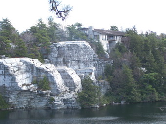
![]() On Saturday, December 2nd my wife, and Sheba and I went back to the
Shawangunks and Minnewaska State Park to hike. I had not been to lake Minnewaska in some time and had forgotten
that is worth the visit all by itself. It had rained the day before and the temperatures had plummeted from
near 60 to below 40. Still, the day was relatively clear with only a few clouds in the sky. The wind near the
lake and the low temperatures made the start of the hike cold. We walked down the carriageway on the western side of
the lake. Looking across to the eastern shore a private residence is visible on the cliff. This house looks like it
is part of the natural rock formations as it blends seamlessly with the surrounding cliff.
On Saturday, December 2nd my wife, and Sheba and I went back to the
Shawangunks and Minnewaska State Park to hike. I had not been to lake Minnewaska in some time and had forgotten
that is worth the visit all by itself. It had rained the day before and the temperatures had plummeted from
near 60 to below 40. Still, the day was relatively clear with only a few clouds in the sky. The wind near the
lake and the low temperatures made the start of the hike cold. We walked down the carriageway on the western side of
the lake. Looking across to the eastern shore a private residence is visible on the cliff. This house looks like it
is part of the natural rock formations as it blends seamlessly with the surrounding cliff.
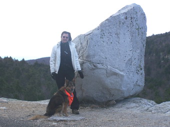 As we turned onto the Millbrook Mountain Carriageway we kept and eye out for Patterson's Pellet. This is one of
MANY glacial erratics found in this area and has acquired a certain fame and popularity with hikers. It even
has its own sign! We stopped briefly here so that I could shed a layer of clothing and get out a lighter hat
and pair of gloves. Once we started hiking I got a lot warmer and I knew this would continue once we started
climbing toward Gertrude's Nose.
As we turned onto the Millbrook Mountain Carriageway we kept and eye out for Patterson's Pellet. This is one of
MANY glacial erratics found in this area and has acquired a certain fame and popularity with hikers. It even
has its own sign! We stopped briefly here so that I could shed a layer of clothing and get out a lighter hat
and pair of gloves. Once we started hiking I got a lot warmer and I knew this would continue once we started
climbing toward Gertrude's Nose.
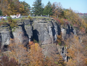
 Gertrude's Nose is a series of cliffs and ledges that form an extension of the Millbrook Ridge. It is accessible
from the Millbrook Ridge Trail but the easiest and shortest approach is from Minnewaska. The Nose offers wonderful
views of the valley below and the surrounding mountains to the south and west. This area has many more glacial
erratics and is crisscrossed by many deep cracks in the rock. Sheba slowed down at this point and seemed to be
picking her way much more carefully. She is VERY protective of anyone who goes near the edge of the cliff. At the
base of the cliffs there are many piles of talus that have split off from the Nose over the years.
Gertrude's Nose is a series of cliffs and ledges that form an extension of the Millbrook Ridge. It is accessible
from the Millbrook Ridge Trail but the easiest and shortest approach is from Minnewaska. The Nose offers wonderful
views of the valley below and the surrounding mountains to the south and west. This area has many more glacial
erratics and is crisscrossed by many deep cracks in the rock. Sheba slowed down at this point and seemed to be
picking her way much more carefully. She is VERY protective of anyone who goes near the edge of the cliff. At the
base of the cliffs there are many piles of talus that have split off from the Nose over the years.
 The trail from the Nose continues on toward Millbrook Ridge and the highest point on the ridge dubbed Millbrook
Mountain. The trail descends some and passes under a set of power lines before making a quick, steep but short
ascent up to the ridge. All along this ridge the views of the valley below are excellent. Several farms dot the
landscape and the village of New Paltz and the state college are visible. It seems that the mountains in the
distance are always in a haze no matter how clear and bright the day. At Millbrook Mountain we turned left or
north on the Millbrook Mountain Trail. This trail was VERY wet and walking down it resembled hiking through a
small creek. We finally got to the Coxing Kill which the trail crosses. The trail then ascends and dries out some.
We continued to ascend over some rather tricky spots until suddenly we arrived at the southern end of Lake Minnewaska.
The trail from the Nose continues on toward Millbrook Ridge and the highest point on the ridge dubbed Millbrook
Mountain. The trail descends some and passes under a set of power lines before making a quick, steep but short
ascent up to the ridge. All along this ridge the views of the valley below are excellent. Several farms dot the
landscape and the village of New Paltz and the state college are visible. It seems that the mountains in the
distance are always in a haze no matter how clear and bright the day. At Millbrook Mountain we turned left or
north on the Millbrook Mountain Trail. This trail was VERY wet and walking down it resembled hiking through a
small creek. We finally got to the Coxing Kill which the trail crosses. The trail then ascends and dries out some.
We continued to ascend over some rather tricky spots until suddenly we arrived at the southern end of Lake Minnewaska.
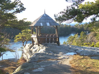 Here we turned right on the carriageway to explore the eastern shore which we had seen at the beginning of our hike.
The road ascend slightly and offers views of the valley for those that don't care to do more hiking than around the
lake. The road winds around the shore taking several detours and making several loops. The very top of the cliff
was the site of one of many boarding houses and hotels that were so popular in the Catskills and Shawangunks. A
little further along a gazebo can be seen perched on a cliff. There were many of these structures along the cliffs
when the boarding houses were in full operation. Today only this one remains. After taking in some of these
views of the lake below, we headed back for the parking area. We couldn't resist walking up and over "Dry Bridge"
which passes over the carriageway below. We hiked about 6.5 miles in 4 hours.
Here we turned right on the carriageway to explore the eastern shore which we had seen at the beginning of our hike.
The road ascend slightly and offers views of the valley for those that don't care to do more hiking than around the
lake. The road winds around the shore taking several detours and making several loops. The very top of the cliff
was the site of one of many boarding houses and hotels that were so popular in the Catskills and Shawangunks. A
little further along a gazebo can be seen perched on a cliff. There were many of these structures along the cliffs
when the boarding houses were in full operation. Today only this one remains. After taking in some of these
views of the lake below, we headed back for the parking area. We couldn't resist walking up and over "Dry Bridge"
which passes over the carriageway below. We hiked about 6.5 miles in 4 hours.
![]()
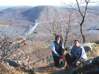
![]() On Saturday, November 25th, my wife, my son Kurt, and Sheba went with me to
hike in Bear Mountain Sate Park. We got a late start, arriving at the Bear Mountain Inn at around 10:15 to find
the annual Alumni Race in progress. The weather has perfect with temperatures in the low 50's and very few clouds
in the sky. We headed out on the foot path which surrounds Hessian Lake. This path is also
part of the Major Welch Trail which turns upwards near the far end of the lake. We began to pass several small groups
of hikers at this point sine we keep up a pretty fast pace. We also met hikers coming down the trail from the top.
This trail is steep at points and has several open rock faces to traverse. A chain at one point provides a little
extra help for those that need it. About 2/3 of the way up, the trail crosses Perkins Drive and continues on to the
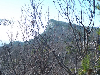
summit of Bear Mountain. The views from the lookouts at the very top of this trail are beautiful. They look down on
the Bear Mountain Bridge across to Anthony's Nose. You can also see up and down the Hudson River with better views
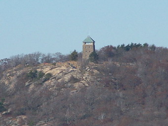
to the north than to the south. We followed the trail to the top and the Perkins Tower. The Tower is closed with
no indication why or if it will open again. We spent some time here looking out at the spectacular views of the
surrounding mountains and the river to the south. Bald Mountain is clearly visible.
On Saturday, November 25th, my wife, my son Kurt, and Sheba went with me to
hike in Bear Mountain Sate Park. We got a late start, arriving at the Bear Mountain Inn at around 10:15 to find
the annual Alumni Race in progress. The weather has perfect with temperatures in the low 50's and very few clouds
in the sky. We headed out on the foot path which surrounds Hessian Lake. This path is also
part of the Major Welch Trail which turns upwards near the far end of the lake. We began to pass several small groups
of hikers at this point sine we keep up a pretty fast pace. We also met hikers coming down the trail from the top.
This trail is steep at points and has several open rock faces to traverse. A chain at one point provides a little
extra help for those that need it. About 2/3 of the way up, the trail crosses Perkins Drive and continues on to the
summit of Bear Mountain. The views from the lookouts at the very top of this trail are beautiful. They look down on
the Bear Mountain Bridge across to Anthony's Nose. You can also see up and down the Hudson River with better views
to the north than to the south. We followed the trail to the top and the Perkins Tower. The Tower is closed with
no indication why or if it will open again. We spent some time here looking out at the spectacular views of the
surrounding mountains and the river to the south. Bald Mountain is clearly visible.
 After a brief break we found the AT and started down this slightly longer but less steep trail. The AT is
clearly marked and crosses Perkins Drive several times before heading down. At one point the trail intersects
a dead end road that leads to a small lookout where many people park to take in the view. The AT then heads down
through mixed pine and hardwood forest. It crosses a small stream and meets up with the Suffern-Bear Mountain Trail.
From hear we went back to the parking area.
After a brief break we found the AT and started down this slightly longer but less steep trail. The AT is
clearly marked and crosses Perkins Drive several times before heading down. At one point the trail intersects
a dead end road that leads to a small lookout where many people park to take in the view. The AT then heads down
through mixed pine and hardwood forest. It crosses a small stream and meets up with the Suffern-Bear Mountain Trail.
From hear we went back to the parking area.
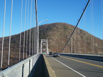 After a short stop at the parking area, we headed out toward Hessian Lake to again pick up the AT. This time we
were headed for Anthony's Nose and another lookout over the Hudson. We headed under 9W in the pedestrian tunnel and
followed the AT to the Bear Mountain Zoo. The Zoo was open but the sign read NO PETS ALLOWED! We pleaded the case for
Sheba but the attendant would not allow us to proceed. We turned around and walked the shoulder of Route 9W to the
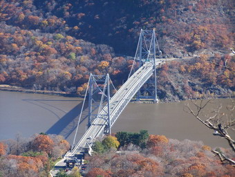
traffic circle. We crossed the road and began the hike across the bridge on the pedestrian walkway. The views up
and down the Hudson from the bridge are beautiful. Even more impressive is the view of Anthony's Nose directly ahead.
This craggy promontory of rock rises 900 feet above the river!
After a short stop at the parking area, we headed out toward Hessian Lake to again pick up the AT. This time we
were headed for Anthony's Nose and another lookout over the Hudson. We headed under 9W in the pedestrian tunnel and
followed the AT to the Bear Mountain Zoo. The Zoo was open but the sign read NO PETS ALLOWED! We pleaded the case for
Sheba but the attendant would not allow us to proceed. We turned around and walked the shoulder of Route 9W to the
traffic circle. We crossed the road and began the hike across the bridge on the pedestrian walkway. The views up
and down the Hudson from the bridge are beautiful. Even more impressive is the view of Anthony's Nose directly ahead.
This craggy promontory of rock rises 900 feet above the river!
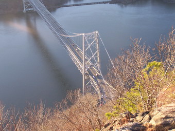 At the end of the bridge we turned left up 9D and
walked the shoulder for about .2 miles until the AT turns into the woods. The trail cuts back several times to make
the climb a little easier. Eventually, however, it cuts up through rocks and gains significant elevation. We gained
about 700 feet in only .7 miles. Several of these climbs are steep but some stone steps and flatter sections help.
At the top of the climb the AT departs to the left. We turned right on a blue trail that is an old woods
road through Camp Smith. This trail winds through the woods and gains a bit more elevation before ending at a T.
Turning left here leads to a lookout over the Hudson but NOT to Anthony's Nose. A right turn is not marked but leads
immediately to the Nose. Here we stopped to take in the breathtaking views up and down the river. I walked pretty
close to the edge to look down at the river almost 900 feet below. The view of the bridge is awesome! We headed
back the way we came and hurried a little as it was nearly 4:00 PM and the shadows were growing long. By the time
we were walking along Hessian Lake it was dusk. We walked 8.5 miles in around 6 hours with plenty of time for
sightseeing.
At the end of the bridge we turned left up 9D and
walked the shoulder for about .2 miles until the AT turns into the woods. The trail cuts back several times to make
the climb a little easier. Eventually, however, it cuts up through rocks and gains significant elevation. We gained
about 700 feet in only .7 miles. Several of these climbs are steep but some stone steps and flatter sections help.
At the top of the climb the AT departs to the left. We turned right on a blue trail that is an old woods
road through Camp Smith. This trail winds through the woods and gains a bit more elevation before ending at a T.
Turning left here leads to a lookout over the Hudson but NOT to Anthony's Nose. A right turn is not marked but leads
immediately to the Nose. Here we stopped to take in the breathtaking views up and down the river. I walked pretty
close to the edge to look down at the river almost 900 feet below. The view of the bridge is awesome! We headed
back the way we came and hurried a little as it was nearly 4:00 PM and the shadows were growing long. By the time
we were walking along Hessian Lake it was dusk. We walked 8.5 miles in around 6 hours with plenty of time for
sightseeing.
![]()
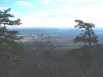
![]() On Friday, November 24th, my sons, Karl and Kurt, and Sheba went with me to
hike in the 'Gunks. For November the weather was perfect, maybe even a little warm, with temperatures in the high
40's. It was sunny with only a few clouds and some haze in the distance. We started at the Trapps Bridge and go
onto the Millbrook Ridge Trail. The trail ascends quickly over rock with mostly scrub pine. The views begin
immediately and are good but nothing like the spectacular views to come! The first views are of the Catskills
in the distance and the surrounding Gunks in the foreground. The view to the left is of the Undercliff/Overcliff
Trail as scene from just above the Trapps parking area. The road is Route 55 just as it passes the Trapps parking
area and approaches the hairpin turn. When we parked there were only a few cars in the lot. When we returned, it
was full of cars belonging to hikers and climbers. As we walked along the ridge the views became more outstanding
including those of New Paltz in the valley below and the Hudson Highlands at a distance.
On Friday, November 24th, my sons, Karl and Kurt, and Sheba went with me to
hike in the 'Gunks. For November the weather was perfect, maybe even a little warm, with temperatures in the high
40's. It was sunny with only a few clouds and some haze in the distance. We started at the Trapps Bridge and go
onto the Millbrook Ridge Trail. The trail ascends quickly over rock with mostly scrub pine. The views begin
immediately and are good but nothing like the spectacular views to come! The first views are of the Catskills
in the distance and the surrounding Gunks in the foreground. The view to the left is of the Undercliff/Overcliff
Trail as scene from just above the Trapps parking area. The road is Route 55 just as it passes the Trapps parking
area and approaches the hairpin turn. When we parked there were only a few cars in the lot. When we returned, it
was full of cars belonging to hikers and climbers. As we walked along the ridge the views became more outstanding
including those of New Paltz in the valley below and the Hudson Highlands at a distance.
 The walk along the ridge is fairly long and we wondered if we would ever get to the point on the map that
was marked Millbrook Mountain. This summit is more like the highest point on the ridge than an actual mountain top.
As we were hiking a mighty crag began to appear in the distance. We could only get glimpses of it through the trees.
We were pretty sure that any view from here would be spectacular. In fact, we were looking at the highest point
on the Millbrook Ridge. As we climbed the ridge toward this high point, it seemed we would never get there. After
each upward climb, there always seemed to be another. Each climb got us closer to the massive outcropping known as
Millbrook Mountain.
The walk along the ridge is fairly long and we wondered if we would ever get to the point on the map that
was marked Millbrook Mountain. This summit is more like the highest point on the ridge than an actual mountain top.
As we were hiking a mighty crag began to appear in the distance. We could only get glimpses of it through the trees.
We were pretty sure that any view from here would be spectacular. In fact, we were looking at the highest point
on the Millbrook Ridge. As we climbed the ridge toward this high point, it seemed we would never get there. After
each upward climb, there always seemed to be another. Each climb got us closer to the massive outcropping known as
Millbrook Mountain.
 At one point along the ridge the trail leads up a knife edge of rock with a long drop on one side. We paused at
this point so that I could take a picture of my companions. We wondered what this trail would be like with even
a light coating of ice or snow! We continued the climb up and up, pausing at each lookout to enjoy the views.
In many of these places it is possible to walk right to the edge of the cliff. I took some pictures but the
perspective is just not the same as being there. These cliffs are some of the highest east of the Mississippi
so caution is the rule of the day. Over the valley, near the cliffs, various species of birds soar on the thermals.
We saw many turkey vultures but also got a glimpse of at least one red-tailed hawk.
At one point along the ridge the trail leads up a knife edge of rock with a long drop on one side. We paused at
this point so that I could take a picture of my companions. We wondered what this trail would be like with even
a light coating of ice or snow! We continued the climb up and up, pausing at each lookout to enjoy the views.
In many of these places it is possible to walk right to the edge of the cliff. I took some pictures but the
perspective is just not the same as being there. These cliffs are some of the highest east of the Mississippi
so caution is the rule of the day. Over the valley, near the cliffs, various species of birds soar on the thermals.
We saw many turkey vultures but also got a glimpse of at least one red-tailed hawk.
 We continued on the trail after the Millbrook high point toward Gertrude's Nose not anticipating that anything could
top what we had already seen. We were wrong! The view from Gertrude's Nose is impressive as is the geology of
the area. Large cracks crisscross this area so watch your step. The trail runs very close to the edge of some
very nasty dropoffs so that you must split your attention between watching your step and taking in the views. After
the Nose we descended a bit until another climb back up to the Millbrook Ridge. We took the Coxing Kill trail back
from Millbrook Mountain and turned right on the Trapps road to get back to the Bridge and our car. The hike was
about 9.5 miles long and took about 5.5 hours including stops to take pictures and take in the views.
We continued on the trail after the Millbrook high point toward Gertrude's Nose not anticipating that anything could
top what we had already seen. We were wrong! The view from Gertrude's Nose is impressive as is the geology of
the area. Large cracks crisscross this area so watch your step. The trail runs very close to the edge of some
very nasty dropoffs so that you must split your attention between watching your step and taking in the views. After
the Nose we descended a bit until another climb back up to the Millbrook Ridge. We took the Coxing Kill trail back
from Millbrook Mountain and turned right on the Trapps road to get back to the Bridge and our car. The hike was
about 9.5 miles long and took about 5.5 hours including stops to take pictures and take in the views.
![]()
![]() On Saturday, November 18th, my wife and I decided to hike even though
it was the first day of deer season. I bought two reflective orange vests and we decided to hike a 3500 peak since
few hunters venture very far up those slopes. We also decided to leave the dog home since it might be more
dangerous for her due to her coloration. The dog had other ideas! So all three of us headed north to the
Blackhead range. I am pleased to say that the vest fit Sheba very nicely. Cindy put on the other and I walked
next to one of them for the whole hike. We parked at the end of Big Hollow Road and were the only car in the lot
at 10:30. I had decided to hike the Black Dome trail up to the Col and then do Blackhead and Black Dome and simply
retrace our route to the parking lot. The trails were VERY wet and required a little creative negotiation. The
second crossing of Batavia Kill, the one without the bridge, was tricky! As we got closer to the peaks we could
see snow on both and heavy mist or cloud cover. The temperature at the trail head was barely 40 degrees but the
"work" of hiking kept us warm. When we reached the col we immediately turned left for the assault on Blackhead.
Parts of this trail are steep but we were undeterred. Near the summit I paused for a moment and caught some
movement on the trail out of the corner of my eye. It was another hiker with her head down moving toward me. I
called Sheba and succeeded in startling the hiker. We talked for a minute and then went on our way. We quickly
arrived at the summit, took a short rest, and started back down. At the col we met another couple who did not
have maps! He assured them that the summit of Blackhead was indeed .6 miles not 6 miles! We began the climb up
Black Dome even though my wife and I were a little tired. The dog is always ready to go! As we started up we met
the same women who had been on Blackhead. Black Dome has several rock scrambles that make the hike interesting.
We hiked to the summit where there is a rock ledge lookout. You could lookout but you couldn't see anything since
clouds surrounded the summit. As we retraced our steps, we met up with the couple who had been in the col. I was
surprised since they had indicated they might do the loop by going down the other side of Blackhead. They said
the lure of two peaks was just too strong! On our way back down we caught up with a family of three and passed them.
We were really moving by now. Near the end of the trail we met another solo hiker starting up. This was about
2:30 and I wondered if he could make it up and back before dark. He seemed to know what he was doing so we
continued on to the car.
On Saturday, November 18th, my wife and I decided to hike even though
it was the first day of deer season. I bought two reflective orange vests and we decided to hike a 3500 peak since
few hunters venture very far up those slopes. We also decided to leave the dog home since it might be more
dangerous for her due to her coloration. The dog had other ideas! So all three of us headed north to the
Blackhead range. I am pleased to say that the vest fit Sheba very nicely. Cindy put on the other and I walked
next to one of them for the whole hike. We parked at the end of Big Hollow Road and were the only car in the lot
at 10:30. I had decided to hike the Black Dome trail up to the Col and then do Blackhead and Black Dome and simply
retrace our route to the parking lot. The trails were VERY wet and required a little creative negotiation. The
second crossing of Batavia Kill, the one without the bridge, was tricky! As we got closer to the peaks we could
see snow on both and heavy mist or cloud cover. The temperature at the trail head was barely 40 degrees but the
"work" of hiking kept us warm. When we reached the col we immediately turned left for the assault on Blackhead.
Parts of this trail are steep but we were undeterred. Near the summit I paused for a moment and caught some
movement on the trail out of the corner of my eye. It was another hiker with her head down moving toward me. I
called Sheba and succeeded in startling the hiker. We talked for a minute and then went on our way. We quickly
arrived at the summit, took a short rest, and started back down. At the col we met another couple who did not
have maps! He assured them that the summit of Blackhead was indeed .6 miles not 6 miles! We began the climb up
Black Dome even though my wife and I were a little tired. The dog is always ready to go! As we started up we met
the same women who had been on Blackhead. Black Dome has several rock scrambles that make the hike interesting.
We hiked to the summit where there is a rock ledge lookout. You could lookout but you couldn't see anything since
clouds surrounded the summit. As we retraced our steps, we met up with the couple who had been in the col. I was
surprised since they had indicated they might do the loop by going down the other side of Blackhead. They said
the lure of two peaks was just too strong! On our way back down we caught up with a family of three and passed them.
We were really moving by now. Near the end of the trail we met another solo hiker starting up. This was about
2:30 and I wondered if he could make it up and back before dark. He seemed to know what he was doing so we
continued on to the car.
![]() On Wednesday, November 15th, I was feeling a little ill
in the morning and called in sick. As the day progressed I felt better and knew that taking a walk
would even further improve my condition. I am trying to hike all 35 peaks in each month so I looked
at my "grid". I decided to try Slide and headed out. It was not raining but a heavy mist hung
in the air. It was warm but with a threat of rain. I parked and went to look at the Neversink
River just behind the trail head parking. It seemed passable so I signed into the trail register
and started the hike. I was trying out a new pack, a Marmot Vapor. My initial impression was not
good until I realized that I had just thrown the pack on my back without making the proper
adjustments. After getting the pack in the proper position, it fit very nicely and was just the
right size to carry what I need for a short day hike. As I turned up the mountain, there was some
commotion in the woods to my left. I looked over to see two black bears running away from me. I continued
on up the mountain. At 3500 feet the temperature drop was noticeable. At the top there was no view since
I was standing in a cloud. I took a drink, ate a bar and hurried back the way I came. On the way down I
saw another bear far off in the woods. A little more than 5 miles and 3 bears in just over 2 hours. Priceless!
On Wednesday, November 15th, I was feeling a little ill
in the morning and called in sick. As the day progressed I felt better and knew that taking a walk
would even further improve my condition. I am trying to hike all 35 peaks in each month so I looked
at my "grid". I decided to try Slide and headed out. It was not raining but a heavy mist hung
in the air. It was warm but with a threat of rain. I parked and went to look at the Neversink
River just behind the trail head parking. It seemed passable so I signed into the trail register
and started the hike. I was trying out a new pack, a Marmot Vapor. My initial impression was not
good until I realized that I had just thrown the pack on my back without making the proper
adjustments. After getting the pack in the proper position, it fit very nicely and was just the
right size to carry what I need for a short day hike. As I turned up the mountain, there was some
commotion in the woods to my left. I looked over to see two black bears running away from me. I continued
on up the mountain. At 3500 feet the temperature drop was noticeable. At the top there was no view since
I was standing in a cloud. I took a drink, ate a bar and hurried back the way I came. On the way down I
saw another bear far off in the woods. A little more than 5 miles and 3 bears in just over 2 hours. Priceless!
![]()
![]() On Saturday, November 11th, I returned to Bear Mountain
State Park with my wife and Sheba. The weather was hazy and overcast with little sun. The sky looked
threatening although the forecast did not call for rain until later in the day. We parked on 9W
near the beginning of the trail up to the Dunderberg Mountains. We were in luck as the sun kept
trying to burn off the fog and succeeded at about 11:00 AM. The trail head was not easy to find
since it is further south along 9W. As with most of the trails in Bear Mountain and Harriman, only
a small blaze on a tree or stake acknowledge the trail. There are no signs to tell you what trail
your are on or where it starts. Maps and a compass are a must!
On Saturday, November 11th, I returned to Bear Mountain
State Park with my wife and Sheba. The weather was hazy and overcast with little sun. The sky looked
threatening although the forecast did not call for rain until later in the day. We parked on 9W
near the beginning of the trail up to the Dunderberg Mountains. We were in luck as the sun kept
trying to burn off the fog and succeeded at about 11:00 AM. The trail head was not easy to find
since it is further south along 9W. As with most of the trails in Bear Mountain and Harriman, only
a small blaze on a tree or stake acknowledge the trail. There are no signs to tell you what trail
your are on or where it starts. Maps and a compass are a must!
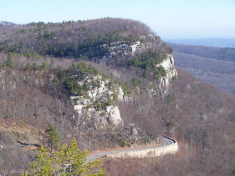
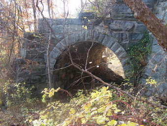
In the late 1800's, a company began building a "spiral railway" to haul tourist to the top of the mountain using a cable and "donkey" engine since the grade is so steep. Once up on the mountain the visitors could see a view of the Hudson River spread out below. In two year many of the beds were built up and graded. A tunnel was started through a part of the mountain. After two years, the project was abandoned. Over 100 years later the graded beds are obvious in many places and the tunnel is still there.
The hike up to the first level of the ridge is steep but short. We turned left on the Ramapo-Dunderberg trail and headed along the ridge toward The Timp. This trail alternates between flat sections and switchbacks that ascend to the next height on the ridge. When we reached the 1777 Trail, we decided to forgo The Timp and tuned right on 1777. After less than a quarter mile, we again turned right on the Ramapo-Dunderberg and headed for Bald Mountain. The climb is steady and steep in a few places. The view of Bear Mountain and the Bridge were about the same as Friday with some haze still obscuring a clear view. After a brief rest at the top of Bald we continued on across the Dunderberg ridge. The trail alternates between short but steep ascents and descents and some flatter areas. At the eastern end the terrain and flora become very interesting. The area appears to have been burned over at some time since most trees are dead or dying. This gives the area a desolate appearance with much bare rock a few low shrubs. Some areas have collected water and have the flora of a swamp or marsh.
 The views all along this ridge are interesting but the
ones from this eastern end are spectacular since very little blocks the view. Several spur trails
lead to lookouts which give a virtually unimpeded view of the Hudson River. The trail turns south
and west and descends. The last part of the trail is along the graded railroad bed where the
train cars were to be pulled up by cable. This part of the trail can be tricky to hike as the
large, broken rocks often shift under foot. We did a little over 6 miles in four hours including
several short stops and breaks to take pictures
The views all along this ridge are interesting but the
ones from this eastern end are spectacular since very little blocks the view. Several spur trails
lead to lookouts which give a virtually unimpeded view of the Hudson River. The trail turns south
and west and descends. The last part of the trail is along the graded railroad bed where the
train cars were to be pulled up by cable. This part of the trail can be tricky to hike as the
large, broken rocks often shift under foot. We did a little over 6 miles in four hours including
several short stops and breaks to take pictures
![]()
![]()
![]() On Friday, November 10th, I decided to try my first hike
in Bear Mountain State Park. The dog and I got an early start since it gets dark early in the woods
after the time change. We parked at The Bear Mountain Inn and hiked along Hessian Lake on the Major
Welch trail with the intent of hiking the loop over Bear Mountain. The day was cool but clear; a
really beautiful day for hiking. I thought I knew where the trail turned up into the woods but I
was wrong! After several aborted attempts, I decided to reverse the loop since I knew the other
trail went up the ski hill. As we backtracked along Hessian Lake, we met a Boy Scout Troop. The
leaders seemed to know where they were going. I wished them a good hike and told them I would meet
them tat he top. We picked up the AT at this point and followed it pretty easily up toward the top
of the mountain and the Perkins Tower. The ascent had some steeper parts but none that were too
taxing. Some areas did have bare rock at a rather imposing angle but these were negotiable.
Along the way there were several nice lookouts. A one point, near the top, I lost the AT and ended
up bushwhacking through open country where others seemed to have hiked. The trail markings are
splashes of paint on the trees. There are NO SIGNS at all for the start of the trails or any turns.
For someone new to these trails, a map and map and compass are VERY helpful. My GPS would have
been more useful had I remembered to load the contour maps for the area! Soon we arrived at the top
where I took some pictures of a couple from New Jersey. We wondered around a little but finally found
the red-blazed Major Welch Trail. At this point the Boy Scouts showed up and we talked for a minute.
This trail initially leads across the relatively flat top of the mountain. Eventually it leads down
the other side but not before offering some SPECTACULAR views of the Hudson River, the Bear
Mountain Bridge on the surrounding area. The descent was difficult. It was steep with several areas
of open rock that made keeping a grip difficult. The covering of leaves added to the excitement.
The eventually trail joins the loop trail around Hessian Lake. I was surprised that there was no sign
or outstanding markings indicating where the trail turns off this path. If you haven't hiked the
trail before, you would miss the turn as I did.
On Friday, November 10th, I decided to try my first hike
in Bear Mountain State Park. The dog and I got an early start since it gets dark early in the woods
after the time change. We parked at The Bear Mountain Inn and hiked along Hessian Lake on the Major
Welch trail with the intent of hiking the loop over Bear Mountain. The day was cool but clear; a
really beautiful day for hiking. I thought I knew where the trail turned up into the woods but I
was wrong! After several aborted attempts, I decided to reverse the loop since I knew the other
trail went up the ski hill. As we backtracked along Hessian Lake, we met a Boy Scout Troop. The
leaders seemed to know where they were going. I wished them a good hike and told them I would meet
them tat he top. We picked up the AT at this point and followed it pretty easily up toward the top
of the mountain and the Perkins Tower. The ascent had some steeper parts but none that were too
taxing. Some areas did have bare rock at a rather imposing angle but these were negotiable.
Along the way there were several nice lookouts. A one point, near the top, I lost the AT and ended
up bushwhacking through open country where others seemed to have hiked. The trail markings are
splashes of paint on the trees. There are NO SIGNS at all for the start of the trails or any turns.
For someone new to these trails, a map and map and compass are VERY helpful. My GPS would have
been more useful had I remembered to load the contour maps for the area! Soon we arrived at the top
where I took some pictures of a couple from New Jersey. We wondered around a little but finally found
the red-blazed Major Welch Trail. At this point the Boy Scouts showed up and we talked for a minute.
This trail initially leads across the relatively flat top of the mountain. Eventually it leads down
the other side but not before offering some SPECTACULAR views of the Hudson River, the Bear
Mountain Bridge on the surrounding area. The descent was difficult. It was steep with several areas
of open rock that made keeping a grip difficult. The covering of leaves added to the excitement.
The eventually trail joins the loop trail around Hessian Lake. I was surprised that there was no sign
or outstanding markings indicating where the trail turns off this path. If you haven't hiked the
trail before, you would miss the turn as I did.
 After a short break Sheba and I got in the car for the short drive down 9W south to the parking
area for the Cornell Mine trail. After parking, we looked for the start of the trail. Again, no sign
or outstanding markings to show where the trail started. The map helped me located the beginning of
the trail and we immediately set out. The first part of the trail parallels a small brook. The
recent rain meant that the brook was roaring with several pretty cascades and water falls. The trail
levels for a while as it windings through open forest and between several rises and large rocks.
As you hike it is obvious from the terrain ahead and the contour lines on the map that the ascent
ahead is steep. The trail begins the ascent up to the ridge and Bald Mountain rather easily. Soon
the trail is steep with many switchbacks to aid the hiker. Just when you think you are near the
top and the trail can't get any steeper, IT DOES! The Cornell Mine Trail ends at the junction with
the Suffern-Ramapo Trail. We turned right and made the last ascent up to Bald Mountain. The reward
at the top was worth the climb! The views were fantastic! I immediately noticed the Perkins Tower
over on Bear Mountain and the Bear Mountain Bridge below. I had intended to hike the loop through
the Dunderberg Mountains but it was getting late in the day. We turned around and headed down
the way we had come. I decided to leave the loop for another day.
After a short break Sheba and I got in the car for the short drive down 9W south to the parking
area for the Cornell Mine trail. After parking, we looked for the start of the trail. Again, no sign
or outstanding markings to show where the trail started. The map helped me located the beginning of
the trail and we immediately set out. The first part of the trail parallels a small brook. The
recent rain meant that the brook was roaring with several pretty cascades and water falls. The trail
levels for a while as it windings through open forest and between several rises and large rocks.
As you hike it is obvious from the terrain ahead and the contour lines on the map that the ascent
ahead is steep. The trail begins the ascent up to the ridge and Bald Mountain rather easily. Soon
the trail is steep with many switchbacks to aid the hiker. Just when you think you are near the
top and the trail can't get any steeper, IT DOES! The Cornell Mine Trail ends at the junction with
the Suffern-Ramapo Trail. We turned right and made the last ascent up to Bald Mountain. The reward
at the top was worth the climb! The views were fantastic! I immediately noticed the Perkins Tower
over on Bear Mountain and the Bear Mountain Bridge below. I had intended to hike the loop through
the Dunderberg Mountains but it was getting late in the day. We turned around and headed down
the way we had come. I decided to leave the loop for another day.
The hiking was great and the views wonderful. Having Sheba along is really fun. She is well behaved and a real help in finding and staying on the trails. Everyone comments on how pretty she is. On the way down the Cornell Mine trail I just followed her lead; seldom looking at the blazes.
![]()
![]() On Saturday, November 4th, I decided to take my wife
and the dog to Thacher Park. I was so impressed the first time that I wanted to share it with someone
else. The temperature when we left Manor at 8:00 AM was still in the low 30's and I wasn't
expecting the weather up north to be much warmer. We passed through some areas with ominous
shies on the way. When we arrived a the park it was still cool with a slight wind but the skies
were clear with only a few clouds. I had on three layers including the Mountain Hardwear Windstopper jacket. I
dropped the middle layer fleece after finishing the Indian ladder but wore the jacket, mostly
unzipped the whole day. Gloves and a hat were necessary at times. I tried the Osprey Atoms 50
and it is VERY comfortable. I packed it pretty full with clothing and some accessories I really
didn't need just to see how it packed and carried. It rides a little higher than some packs but
it fits my pack perfectly. We did the entire loop as I did it last time. The waterfalls had
a little more output and some of the trails were a little wetter. Sheba had to be "encouraged"
to go down and up some of the open stairs. On the way to the park I remembered that the Indian
Ladder closes in the fall. We were in luck since it CLOSES NOVEMBER 15th!
On Saturday, November 4th, I decided to take my wife
and the dog to Thacher Park. I was so impressed the first time that I wanted to share it with someone
else. The temperature when we left Manor at 8:00 AM was still in the low 30's and I wasn't
expecting the weather up north to be much warmer. We passed through some areas with ominous
shies on the way. When we arrived a the park it was still cool with a slight wind but the skies
were clear with only a few clouds. I had on three layers including the Mountain Hardwear Windstopper jacket. I
dropped the middle layer fleece after finishing the Indian ladder but wore the jacket, mostly
unzipped the whole day. Gloves and a hat were necessary at times. I tried the Osprey Atoms 50
and it is VERY comfortable. I packed it pretty full with clothing and some accessories I really
didn't need just to see how it packed and carried. It rides a little higher than some packs but
it fits my pack perfectly. We did the entire loop as I did it last time. The waterfalls had
a little more output and some of the trails were a little wetter. Sheba had to be "encouraged"
to go down and up some of the open stairs. On the way to the park I remembered that the Indian
Ladder closes in the fall. We were in luck since it CLOSES NOVEMBER 15th!
 We took Route 30 back and found the Vroman's Nose is right off this route in Middleburgh.
This is a short hike but we left it for another day. We DID stop by MineKill State Park to see
the falls. We wondered around for a while until we discovered that the best overlook is another
half mile down 30. By the time we got there it was closed! Another hike for another day. We
drove to Conesville to see the Manor Kill falls. It was getting dark but the falls were pretty.
This route also goes by the Schoharie Reservoir which is pretty impressive. All in all a good
day with some ideas for another trip.
We took Route 30 back and found the Vroman's Nose is right off this route in Middleburgh.
This is a short hike but we left it for another day. We DID stop by MineKill State Park to see
the falls. We wondered around for a while until we discovered that the best overlook is another
half mile down 30. By the time we got there it was closed! Another hike for another day. We
drove to Conesville to see the Manor Kill falls. It was getting dark but the falls were pretty.
This route also goes by the Schoharie Reservoir which is pretty impressive. All in all a good
day with some ideas for another trip.
![]() On Saturday, October 28th, it was rainy with winds from 10 to 30 mph. The
forecast was calling for conditions to worsen. A break in the weather came at around noon so my wife, my son Karl, my
dog Sheba and I decided to try to get in some hiking. We headed for Sam's Point Preserve intending to at least get to
the Ice Caves. My son had never been there and my wife had not seen them in over 15 years. The last time she and I
were at the preserve we hike the long way around and she was too tired to get to the caves that day. It wasn't raining
when we parked so we quickly headed right up to Sam's Point. We bypassed the Point and went directly to the Caves.
There was a LOT of water on the way running along the paths or sitting in ponds across the path. We found out
why the road down to the Caves is so eroded. Several times a small creek created by runoff crossed the path.
As we approached the caves we could see the Verkeerder Kill falls roaring with the increased water volume. The
trek through the caves was wet but enjoyable. It is definitely colder down in the "caves" but we did not see any
ice. As we returned to the entrance of the caves the sky took an the dark an ominous appearance of imminent
precipitation. We decided to return to the car since the weather seemed so unsettled. As we approached the
loop road it began to rain hard! At times there was a mix of rain and sleet. My son and I were not wearing
waterproof pants and were quickly drenched. The precipitation abated and the wind picked up with gusts at times
of 40 mph. We hiked quickly, stopping by Sam's Point for only a moment. We were glad to be back to the car
before any more serious precipitation fell. On the way down we greeted a group of 6 people heading up the path.
On Saturday, October 28th, it was rainy with winds from 10 to 30 mph. The
forecast was calling for conditions to worsen. A break in the weather came at around noon so my wife, my son Karl, my
dog Sheba and I decided to try to get in some hiking. We headed for Sam's Point Preserve intending to at least get to
the Ice Caves. My son had never been there and my wife had not seen them in over 15 years. The last time she and I
were at the preserve we hike the long way around and she was too tired to get to the caves that day. It wasn't raining
when we parked so we quickly headed right up to Sam's Point. We bypassed the Point and went directly to the Caves.
There was a LOT of water on the way running along the paths or sitting in ponds across the path. We found out
why the road down to the Caves is so eroded. Several times a small creek created by runoff crossed the path.
As we approached the caves we could see the Verkeerder Kill falls roaring with the increased water volume. The
trek through the caves was wet but enjoyable. It is definitely colder down in the "caves" but we did not see any
ice. As we returned to the entrance of the caves the sky took an the dark an ominous appearance of imminent
precipitation. We decided to return to the car since the weather seemed so unsettled. As we approached the
loop road it began to rain hard! At times there was a mix of rain and sleet. My son and I were not wearing
waterproof pants and were quickly drenched. The precipitation abated and the wind picked up with gusts at times
of 40 mph. We hiked quickly, stopping by Sam's Point for only a moment. We were glad to be back to the car
before any more serious precipitation fell. On the way down we greeted a group of 6 people heading up the path.
![]() On Tuesday, October 24th, I got home from the county wide conference
early. My wife and I decided to take the dog and speed hike around Trout Pond. The weather was cool with some
mixed rain, sleet and snow.
On Tuesday, October 24th, I got home from the county wide conference
early. My wife and I decided to take the dog and speed hike around Trout Pond. The weather was cool with some
mixed rain, sleet and snow.
![]() On Saturday, October 14th, my daughter was home from college for the
weekend. My wife, my daughter and my dog headed for the familiar Trout Pond loop that we have done so many times.
We had A VERY limited amount of time and got on the trail as soon as we parked. We hiked in the clockwise
direction. This puts ALL of the climbing at the beginning of the hike. It really gets the blood pumping
right away but makes for a downhill hike all the way back to the car. Somewhere along the route from Mud to
Trout Sheba stepped on something that punctured the webbing between the toes on her rear foot. She bled a little
and limped some but seemed to be OK. We covered the whole loop in well under two hours!
On Saturday, October 14th, my daughter was home from college for the
weekend. My wife, my daughter and my dog headed for the familiar Trout Pond loop that we have done so many times.
We had A VERY limited amount of time and got on the trail as soon as we parked. We hiked in the clockwise
direction. This puts ALL of the climbing at the beginning of the hike. It really gets the blood pumping
right away but makes for a downhill hike all the way back to the car. Somewhere along the route from Mud to
Trout Sheba stepped on something that punctured the webbing between the toes on her rear foot. She bled a little
and limped some but seemed to be OK. We covered the whole loop in well under two hours!
![]()
![]() On Monday, October 9th, I decided to again leave the Catskills. This time
I headed for John Boyd Thacher State Park outside of Voorheesville! This is only 15 miles SW of Albany. I took a
somewhat roundabout route but was at the park within 2 and a half hours. I started at 7:15 AM so there were only few
cars The park contains the Helderberg Escarpment which has two deposits of Devonian limestone. It is rich in fossils
from a shallow see that covered this area during that period. I could see imprints in the rock by my fossil
identification skills leave a lot to be desired. This escarpment is the one pictured in the movie "Last of the
Mohicans".
On Monday, October 9th, I decided to again leave the Catskills. This time
I headed for John Boyd Thacher State Park outside of Voorheesville! This is only 15 miles SW of Albany. I took a
somewhat roundabout route but was at the park within 2 and a half hours. I started at 7:15 AM so there were only few
cars The park contains the Helderberg Escarpment which has two deposits of Devonian limestone. It is rich in fossils
from a shallow see that covered this area during that period. I could see imprints in the rock by my fossil
identification skills leave a lot to be desired. This escarpment is the one pictured in the movie "Last of the
Mohicans".
 I began the hike at the Indian Ladder trail in the middle of the escarpment. The ladders used to be tree trunks
with branches for rungs. Today there are wooden, stone and steel steps. These allow you to descend into the gorge and
walk next to the limestone cliffs. The different deposits of limestone are evident. The rock has eroded at different
rates and small caverns and underground "rivers" are abundant. The dropoffs in some areas are severe but fences have
been erected in these areas. In two places along the trail, you pass underneath waterfalls. The flow when I was there
was limited but it was still interesting.
I began the hike at the Indian Ladder trail in the middle of the escarpment. The ladders used to be tree trunks
with branches for rungs. Today there are wooden, stone and steel steps. These allow you to descend into the gorge and
walk next to the limestone cliffs. The different deposits of limestone are evident. The rock has eroded at different
rates and small caverns and underground "rivers" are abundant. The dropoffs in some areas are severe but fences have
been erected in these areas. In two places along the trail, you pass underneath waterfalls. The flow when I was there
was limited but it was still interesting.
 When I ascended out of the gorge, I continued along the escarpment on relatively level ground. Walking along
the rim there is an excellent view of the surrounding valley. You can also see the rest of the escarpment rim.
There is a large overlook area where cars can park and people can observe the natural wonders. This is also
a favorite place for "birders" to spot eagles and hawks riding the updrafts. I continued on along the fence that
runs the length of the rim. Various observations point allow views of the valley and the rest of the escarpment.
Where the fence and park end the path continues on for a short distance. There is an interesting cliff face here
and a talus slope and the base. The drop is truly breath taking.
When I ascended out of the gorge, I continued along the escarpment on relatively level ground. Walking along
the rim there is an excellent view of the surrounding valley. You can also see the rest of the escarpment rim.
There is a large overlook area where cars can park and people can observe the natural wonders. This is also
a favorite place for "birders" to spot eagles and hawks riding the updrafts. I continued on along the fence that
runs the length of the rim. Various observations point allow views of the valley and the rest of the escarpment.
Where the fence and park end the path continues on for a short distance. There is an interesting cliff face here
and a talus slope and the base. The drop is truly breath taking.
 At this point I chose to cross the road and walk around the extreme outer edge of the park. The trails pass
through several different environments including hardwood and evergreen forests and an interesting bog/marsh/swamp
area. The last leg of the trail is part of the Long Path. Soon I was back at the Indian Ladder. From here I
walked the trail along the rim in the opposite direction. The Indian Ladder Trail is visible in part as it
winds its way through the gorge. I was easily able to see the trail on the opposing rim where I had been standing
just an hour before. As I returned to the car, I was positive that the drive had been well worth it!
At this point I chose to cross the road and walk around the extreme outer edge of the park. The trails pass
through several different environments including hardwood and evergreen forests and an interesting bog/marsh/swamp
area. The last leg of the trail is part of the Long Path. Soon I was back at the Indian Ladder. From here I
walked the trail along the rim in the opposite direction. The Indian Ladder Trail is visible in part as it
winds its way through the gorge. I was easily able to see the trail on the opposing rim where I had been standing
just an hour before. As I returned to the car, I was positive that the drive had been well worth it!
![]()
![]() On Sunday, October 8th, I decided to take my wife to Sam's Point Preserve
since I had found it so enjoyable the previous Monday. We headed out with the dog after church at about 11:30 PM.
The conditions were much drier than on Monday with very few areas that were even muddy. There were a LOT more
people. Since most people hike to Sam's Point and the Caves, we decided to go in the same direction I had used on
Monday. Lake Maratanza was beautiful and the sun's angle allowed better pictures than on Monday. The deep blue of the
lake is really striking. When we reached the side trail to Indian Rock we decided to go out even though we had a limited
amount of time. When we reached the "end" of the trail, we saw people further away on a rocky area. I realized that I
had missed the trail that actually leads to Indian Rock on Monday! We walked out to the rock plateau and then a little
further to the large boulder that is Indian Rock. I was going to scramble to the top but decided to leave that for
another day. As we approached the falls, an ultralight aircraft flew over. It was VERY low and close to the falls. The
hike up from the falls is a long a tiring one.
On Sunday, October 8th, I decided to take my wife to Sam's Point Preserve
since I had found it so enjoyable the previous Monday. We headed out with the dog after church at about 11:30 PM.
The conditions were much drier than on Monday with very few areas that were even muddy. There were a LOT more
people. Since most people hike to Sam's Point and the Caves, we decided to go in the same direction I had used on
Monday. Lake Maratanza was beautiful and the sun's angle allowed better pictures than on Monday. The deep blue of the
lake is really striking. When we reached the side trail to Indian Rock we decided to go out even though we had a limited
amount of time. When we reached the "end" of the trail, we saw people further away on a rocky area. I realized that I
had missed the trail that actually leads to Indian Rock on Monday! We walked out to the rock plateau and then a little
further to the large boulder that is Indian Rock. I was going to scramble to the top but decided to leave that for
another day. As we approached the falls, an ultralight aircraft flew over. It was VERY low and close to the falls. The
hike up from the falls is a long a tiring one.
 When we got to Ice Caves Road, we decided to hike back to the car and leave Ice Caves and Sam's Point for another
day.
When we got to Ice Caves Road, we decided to hike back to the car and leave Ice Caves and Sam's Point for another
day.
![]()
![]() On Monday, October 2nd, I decided to leave the Catskills and
hike in the 'Gunks. I took the dog and headed for Sam's Point Preserve in Cragsmoor. I had not been
to this area since junior high school when we often visited Ice Caves Mountain. The area has since
been purchased by Open Spaces and is managed by the Nature Conservancy. Let me say up front that the
10.5 mile hike is one of the BEST I have done lately. I will be going back SOON with my wife and anyone
else that wants to come. I was a little wary of the rattlesnake warning especially since I ha the dog with me.
Fortunately, no snakes were to be seen on this hike.
On Monday, October 2nd, I decided to leave the Catskills and
hike in the 'Gunks. I took the dog and headed for Sam's Point Preserve in Cragsmoor. I had not been
to this area since junior high school when we often visited Ice Caves Mountain. The area has since
been purchased by Open Spaces and is managed by the Nature Conservancy. Let me say up front that the
10.5 mile hike is one of the BEST I have done lately. I will be going back SOON with my wife and anyone
else that wants to come. I was a little wary of the rattlesnake warning especially since I ha the dog with me.
Fortunately, no snakes were to be seen on this hike.
 We started at the Nature Conservancy Center at the end of Sam's Point Road where we picked up a map of the trails
and carriageways in the preserve. I decided to take the longest route possible since I ha the time an the weather was
exceptionally beautiful. I wore a light fleece top and heavier pants than usual but really didn't need them after the
first few miles. The first part of the hike is on old carriageways and leads gently upward. It passes several
abandoned berry pickers shacks before arriving at Lake Maratanza. The lake is beautiful from the trail although I
did not walk down to the shore. Near the lake are several large communications towers which somewhat spoil the
pristine nature of the area. Shortly after this area, the path splits. The trail to the right loops around the lake.
We continued straight ahead. After another mile, a trail to the left leads to Indian Rock. The first part of this
trail is through a bog and wooden walkways have been constructed over this area. The view from Indian Rock is to the
west over the valleys below. After returning to the main path, we continued on toward High Point. Several areas on the
trail were VERY wet with small ponds to walk around. Areas by the trail seemed to be true bogs. As we approached High
Point, we could see that we were in for a climb. At the top of this trail, we walked out onto an open rock plateau.
We started at the Nature Conservancy Center at the end of Sam's Point Road where we picked up a map of the trails
and carriageways in the preserve. I decided to take the longest route possible since I ha the time an the weather was
exceptionally beautiful. I wore a light fleece top and heavier pants than usual but really didn't need them after the
first few miles. The first part of the hike is on old carriageways and leads gently upward. It passes several
abandoned berry pickers shacks before arriving at Lake Maratanza. The lake is beautiful from the trail although I
did not walk down to the shore. Near the lake are several large communications towers which somewhat spoil the
pristine nature of the area. Shortly after this area, the path splits. The trail to the right loops around the lake.
We continued straight ahead. After another mile, a trail to the left leads to Indian Rock. The first part of this
trail is through a bog and wooden walkways have been constructed over this area. The view from Indian Rock is to the
west over the valleys below. After returning to the main path, we continued on toward High Point. Several areas on the
trail were VERY wet with small ponds to walk around. Areas by the trail seemed to be true bogs. As we approached High
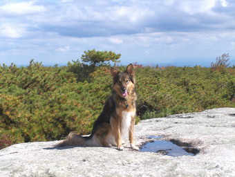
Point, we could see that we were in for a climb. At the top of this trail, we walked out onto an open rock plateau.
 The views in all directions were great but better ones were yet to come. The trail is sometimes hard to follow since
the signage is kept to a minimum. Small dabs of red paint on the rocks or trees and rock cairns mark the trail.
Sheba was helpful since she could smell where people had walked. The view from High Point was magnificent in several
different directions. From here the trail wins downward through more pine barrens and some hardwood. Much of it
consists of a narrow trail with low bushes on the left and a sheer dropoff on the right. As the trail winds its way
along, you can see where you will be hiking and look back at where you have been. Several areas require short but
steep rock scrambling. At one of the lookouts there were raptors riding the currents. I was able to get a nice
closeup!
The views in all directions were great but better ones were yet to come. The trail is sometimes hard to follow since
the signage is kept to a minimum. Small dabs of red paint on the rocks or trees and rock cairns mark the trail.
Sheba was helpful since she could smell where people had walked. The view from High Point was magnificent in several
different directions. From here the trail wins downward through more pine barrens and some hardwood. Much of it
consists of a narrow trail with low bushes on the left and a sheer dropoff on the right. As the trail winds its way
along, you can see where you will be hiking and look back at where you have been. Several areas require short but
steep rock scrambling. At one of the lookouts there were raptors riding the currents. I was able to get a nice
closeup!
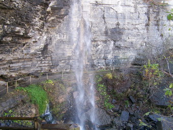
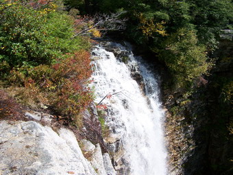
The trail finally takes a rather steep descent toward Verkeerder Kill Falls. You can hear the water rushing over the falls from some distance away. The trail leads to the falls and you can get a pretty good view of the 50+ foot drop. The trail then leads across the Kill just above the falls. The water can be somewhat deep and the footing slick. It looks like a misstep might be a harrowing experience! The path now climbs from the falls which is the lowest point on the trail. It winds through some shrubs, some hardwood and the pine barrens.
 Eventually this trail intersects the Ice Caves road. We turned left and went about .3 miles to the "entrance" of the
Caves. This trail winds for about .5 miles through the tectonic caves. Some areas are open fissures while other
are actually enclosed. It is cool and dank but I did NOT see any ice! I DID discover that dogs do NOT climb ladders.
To get out of the Caves you need to climb two ladders! Sheba simply jumped and scrambled up the rocks. A tasty treat
can be helpful! We walked back up the Ice Caves road until we reached the Lake Loop Road and turned left. Shortly, we
arrived at Sam's Point. The views from here are not as exciting as from some of the other lookouts but they are
nice. From Sam's Point it is less than .5 miles back to the Center.
Eventually this trail intersects the Ice Caves road. We turned left and went about .3 miles to the "entrance" of the
Caves. This trail winds for about .5 miles through the tectonic caves. Some areas are open fissures while other
are actually enclosed. It is cool and dank but I did NOT see any ice! I DID discover that dogs do NOT climb ladders.
To get out of the Caves you need to climb two ladders! Sheba simply jumped and scrambled up the rocks. A tasty treat
can be helpful! We walked back up the Ice Caves road until we reached the Lake Loop Road and turned left. Shortly, we
arrived at Sam's Point. The views from here are not as exciting as from some of the other lookouts but they are
nice. From Sam's Point it is less than .5 miles back to the Center.
![]() On Sunday, September 24th, my wife and I decided to take
the dog a hike around Trout Pond. The weather was "questionable", cloudy with some moisture in the
air, but we took our rain gear and headed out. Sheba LOVES to hike and can't wait to get out. It
seems she can recognize places we have been before. We needed to finish the hike quickly as I had
a soccer game to officiate. We walked at a lively pace and had a good time despite the gloomy weather.
As we headed down the far side of Cherry Ridge toward Mud Pond it began to sprinkle. A little
further on it began to pour. I broke down and donned my rain jacket which did prevent my upper
body from getting soaked to the skin. By the time we were back a the car the rain had stopped, the sun
was peeking through and my pants were thoroughly drenched.
On Sunday, September 24th, my wife and I decided to take
the dog a hike around Trout Pond. The weather was "questionable", cloudy with some moisture in the
air, but we took our rain gear and headed out. Sheba LOVES to hike and can't wait to get out. It
seems she can recognize places we have been before. We needed to finish the hike quickly as I had
a soccer game to officiate. We walked at a lively pace and had a good time despite the gloomy weather.
As we headed down the far side of Cherry Ridge toward Mud Pond it began to sprinkle. A little
further on it began to pour. I broke down and donned my rain jacket which did prevent my upper
body from getting soaked to the skin. By the time we were back a the car the rain had stopped, the sun
was peeking through and my pants were thoroughly drenched.