
| Pick a Catskill 35 Peak: |
Mount Sherrill
North Dome is often done in conjunction with Mount Sherrill. Several different approaches are possible and none are easy. Getting down from Sherrill to the north involves avoiding some treacherous cliffs that come upon you suddenly. Beware of the nettles!
| Trailhead Coordinates | |
|---|---|
| Name | Coordinates |
| Spruceton Road (Mink Hollow) | N 42.1919 W74.3248 |
| Route 42 (Shaft Road) | N42.1659 W74.4088 |
| Quick Look - North Dome and Sherrill from Mink Hollow | ||||
|---|---|---|---|---|
| Difficulty | Round trip | Total climb | Location | Internet Maps |
| 6.3 mi. (7.3 mi.) | 2485 ft. | N42.1733 W74.3494 | AllTrails | |
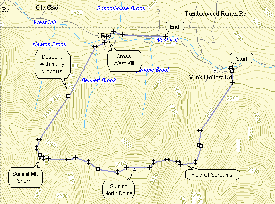
Take Rt. 42 north from Shandaken off Rt. 28. In Spruceton make a right on Spruceton Rd. along the West Kill.
Park at the Mink Hollow parking area on the right just out of Spruceton. Find the
red-blazed Devil's Path. After 1.4 miles you will be in the swamp that signals the beginning of the bushwhack
to North Dome. During the summer this area has biting mosquitoes and stinging nettles. From here you
"head up" which happens to be toward the west. The distance is just less than 2 miles but the climbs are
VERY steep at times and numerous seemingly impossible cliffs block the way. Sometimes the cliffs can be
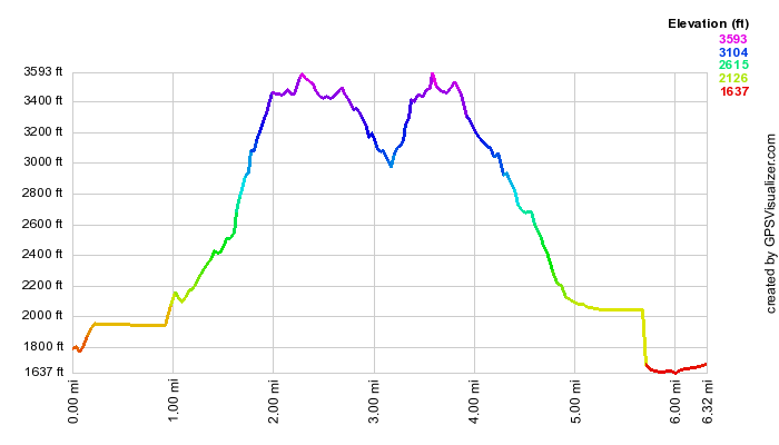
scaled but other times it is better to just go around. The elevation gain is about 1200 ft. until you arrive
at the canister on the summit of North Dome (3610 ft.) Head west again and drop into the Col between North
Dome and Mt. Sherrill. The drop is between 500 and 600 ft. Now the 500 ft. climb to Sherrill begins with
an initial steep area which levels out near the summit of Mt. Sherrill (3540 ft.) The distance between the two peaks is only 1 mile but it seems much longer. From here it is possible to backtrack to return to the parking
area. The cliffs and nettles make another route seem more inviting. Head in a northwesterly direction initially
off the peak. Turn northeast with your objective being the Spruceton Rd. The beginning of the descent is steep
and your main job is to avoid stepping off one of the numerous drop offs that hide in the dense forest. The
total descent is over 1900 ft. in less than 2 miles. Depending on your exact path, you will cross Bennett
Brook at about 1.7 miles and another .2 miles will lead you to a bridge across the West Kill. Crossing
streams can be tricky depending on the amount of water so plan accordingly. Once on the Spruceton Rd. its
about a 1.7 mile walk back to the car but anything is better than the nettles.
| Quick Look - Balsam and Sherrill from Route 42 | ||||
|---|---|---|---|---|
| Difficulty | Round trip | Total climb | Location | Internet Maps |
| 5.2 mi. | 2179 ft. | N42.1733 W74.3494 | AllTrails | |
Take Rt. 42 north from Shandaken off Rt. 28. Drive north 3.7 miles and watch for Shaft Road and a small parking area on your right. Park in the small area to begin this bushwhack. The route described here goes up to a Balsam Mountain first and then traverses over to Sherrill. This Balsam is not on any list so you can decide to take this route or not. Without Balsam you could easily decide to do North Dome also either as an out and back or a car spot.
Walked up the access road to the Catskill Aqueduct shaft all the way to the shaft and then head up the hill. You may intersect an old woods road which makes the going easier but be sure it is headed in the right direction. The road often leads through old stone walls and parallels a stream. Soon the road is too overgrown and the bushwhacking begins in earnest. By paralleling the stream you will be headed for the col between Balsam and Sherrill. The deep ravine that the seemingly small stream has cut over the years is very impressive. On the opposite side you can see that the ascent would be too steep. Head for the highest spot on this Balsam Mountain. The terrain gets steeper as you go and you may find a drainage area that goes up the mountain. Soon the hike is more of a climb until you begin to see VERY steep ground leading to the base of some nasty looking cliffs and ledges. Head directly for the ledges and look for breaks in the cliffs to get you to the top. You may NOT be on the highest spot of the ridge and the brush can get pretty thick. Several more climbs and negotiating some really challenging boulder fields should get you to the highest point. You may find a boulder with a rock cairn on top to mark the summit. Take a bearing to Sherrill and consult your map before heading southwest toward the col and a narrow "bridge" of land between the two peaks.
This part of the hike will alternate between relatively open areas followed by more dense brush. Keep you bearings and reorient yourself each time you stray off course to avoid impenetrable areas. As you near Sherrill, head slightly north to avoid the steepest climbs and ledges on the west and south side of Sherrill. This makes the hike to the summit less steep although there are still some challenging spots. Find the canister and sign in. To avoid Balsam on the return trip take a southwest bearing to get down the steepest parts and then head almost due west to rejoin your previous route at the top of the stream in the col. Try to stay far enough north to avoid descending the steep drainage of the stream. Eventually you should be back on your path from earlier in the day which you can follow back to the car.