| Pick a Catskill 35 Peak: |
Eagle
Eagle is often done in conjunction with Balsam. Several approaches are possible with the shorter ones being steep and the gentler climbs being long.
| Trailhead Coordinates | |
|---|---|
| Name | Coordinates |
| McKinley Hollow | N42.0710 W74.4740 |
| Rider Hollow | N42.1019 W74.5170 |
| Lost Clove | N42.1058 W74.4701 |
| Biscuit Brook | N41.9911 W74.4849 |
| Segar Hollow | N42.0579 W74.5390 |
| Quick Look - Eagle and Balsam from McKenley Hollow | ||||
|---|---|---|---|---|
| Difficulty | Round trip | Total climb | Location | Internet Maps |
| 8.8 mi. | 2910 ft. | N42.0619 W74.5097 | AllTrails | |
Take the Claryville Rd. north from Rt. 55 in Curry outside of Grahamsville. Just short of Claryville turn left onto the Frost Valley Rd. Pass the Frost Valley YMCA camp and continue on passing the Big Indian and Slide Mt. trail heads of the right and the Panther Mt. Parking area at the hairpin turn on the left. Look for McKenley Hollow Rd. on the left. You may also come in from Rt. 28 in Big Indian and look for McKenley Hollow Rd. on your right. Turn here, drive to the end of the road and pull into the parking area.
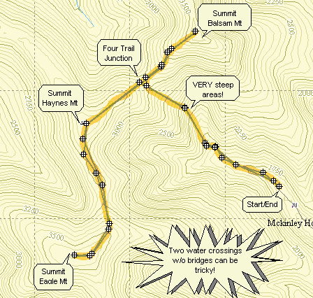
Walk up the road and look for the red-blazed Oliveria-Mapledale trail on the left. Turn onto this trail and cross a bridge over a stream. There are two MORE water crossings that do NOT have bridges and can be tricky after it has rained. In .6 miles you will be at the lean-to. Pass the lean-to and watch as the trail turns left and crosses the stream. Continue for another 1.15 miles on this trail at which point it crosses the blue-blazed Pine Hill-West Branch Trail. This trail is VERY STEEP in places and can be interesting both ascending and descending! It is also lined with nettles during the spring and summer.
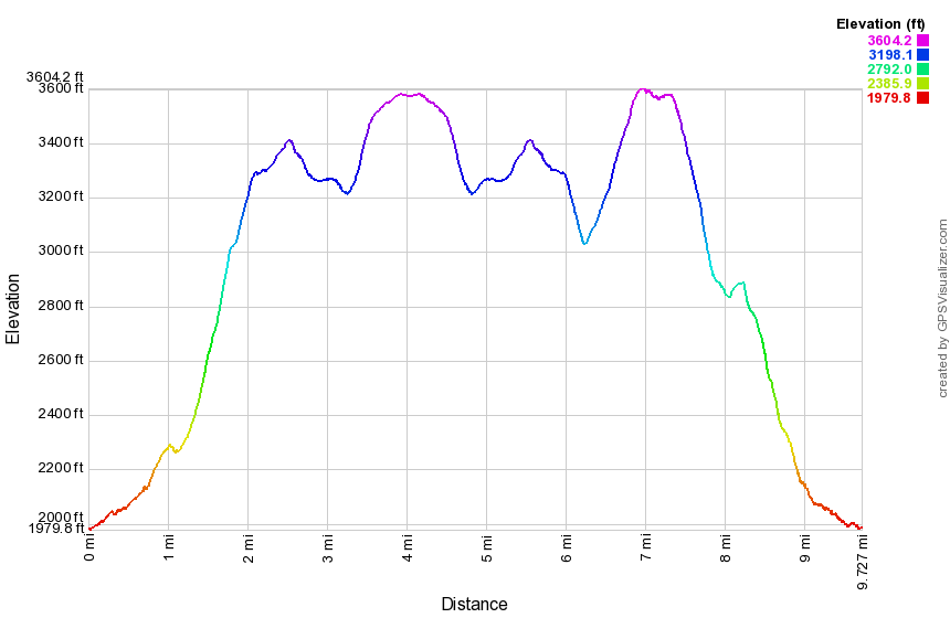
Turn left on the blue-blazed trail. Stay on this trail for 2.15 miles to reach the summit of Eagle Mt. (3600 ft.).
You will also pass over Haynes Mt. which falls only 80 ft. short of being 3500. Turn around and
backtrack along the blue-blazed trail to the junction with the red-blazed Oliveria-Mapledale trail. Turn
right to return to the parking area. Continue straight ahead for .75 miles to the summit of Balsam Mt.
(3600 ft.). Turn around and retrace your route to the red-blazed trail. Turn left and hike 1.85 miles
back to the parking area.
| Quick Look - Eagle and Balsam from Rider Hollow | ||||
|---|---|---|---|---|
| Difficulty | Round trip | Total climb | Location | Internet Maps |
| 9.7 mi. | 2880 ft. | N42.0619 W74.5097 | AllTrails | |
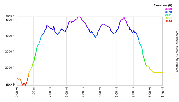
From Route 28 in Arkville take Dry Brook Road toward Mapledale. There are other possibilities but this may be the easiest the first time. Continue on Dry Brook Road until the hamlet of Mapledale. Turn left on Todd Mountain Road. Bear to the left when Baker Road goes slightly right. Pass over the bridge and take the next right. This road is not marked but is Rider Hollow Road. If you need to ask for directions, mention the Hardenburgh Town Hall! Continue on this road as it narrows and becomes a dirt road. Park in the parking area at the end.
Out of the parking area take the red Oliveria Mapledale Trail. At .5 miles bear right to stay on the OM Trail which gains 1020 feet over the next 1.3 miles averaging a 14% grade. At 1.9 miles turn right on the blue Pine hill-West Branch Trail. You will be headed toward Eagle mountain as your goal but mist climb over Haynes Mountain first. At 2.6 miles you will be at the top of Haynes and will descend the other side before climbing Eagle. It is 1.5 miles from the summit of Haynes to the summit of Eagle at 4 miles into the hike. A short path leads to the right or north to the canister. Turn around and hike back to the junction with the Oliveria Mapledale Trail. If you just want Eagle, turn left and walk back downhill to your car. Continue straight ahead on the Pine Hill-West Branch Trail toward Balsam Mountain. From the junction it is about .7 miles to the summit of Balsam after gaining 555 feet on a 16% grade. Watch carefully for a nice lookout on the right side of the trail. Continue on the Pine Hill-West Branch Trail for 1.3 miles walking downhill along the Catskill Divide dropping 800 feet of elevation. At 8.25 miles turn left on the yellow Mine Hollow Trail. Walk another mile downhill losing another 785 feet to the junction with the Oliveria Mapledale Trail. Turn right and walk out to the parking area.