| Pick a Catskill 35 Peak: |
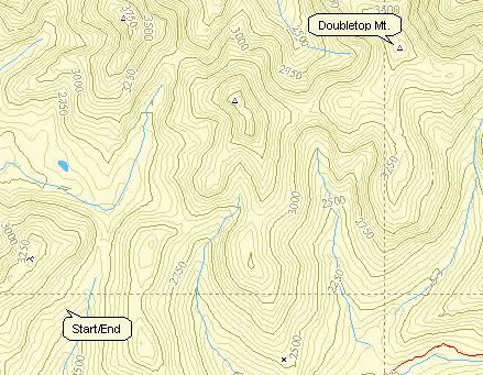
Doubletop Mountain
| Trailhead Coordinates | |
|---|---|
| Name | Coordinates |
| Biscuit Brook | N41.9911 W74.4849 |
| Segar Hollow | N42.0579 W74.5390 |
| Black Bear Road | N41.9800 W74.5754 |
| Quick Look - from Black Bear Road | ||||
|---|---|---|---|---|
| Difficulty | Round trip | Total climb | Location | Internet Maps |
| 9.5 mi. | 1865 ft. | N42.0275 W74.5286 | AllTrails | |
Take DeBrue Rd. out of Livingston Manor. DeBruce Road becomes Willowemoc Road and then
Pole Rd. After almost 15 miles, Wild Meadow Road (Black Bear Road) is on the left. Turn left and continue until the
end of the road where there is a snow plow turn around. You may park here except when there may be the need for a snow plow to turn around. The road continues as a rutted woods road and passes a hunting camp before becoming the yellow-blazed Neversink-Hardenburgh trail. Stay on this trail
for a little over 3 miles until the Fall Brook lean-to. This trail can be very wet at times as it crosses
Fall Brook and skirts several beaver ponds. From the lean-to walk about 1 mile on the trail and then
head to the right into the woods just short of the headwaters of the Beaverkill. Continue toward the northeast checking your bearing when you feel the need. You may
hit a herd path that leads to the summit. Near the top the path crosses a bear run that extends around
the crown of the mountain and sports a two-engine plane wreck. The canister at the top is on a rather
well defined path but is about 2 to 3 miles from where you turned off the trail. Since this is a
bushwhack, you can follow the same route back or design another one.
| Quick Look - from Biscuit Brook | ||||
|---|---|---|---|---|
| Difficulty | Round trip | Total climb | Location | Internet Maps |
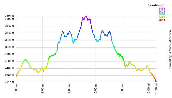
| 10.6 mi. | 3164 ft. | N42 01.63 W74 31.70 | AllTrails | |
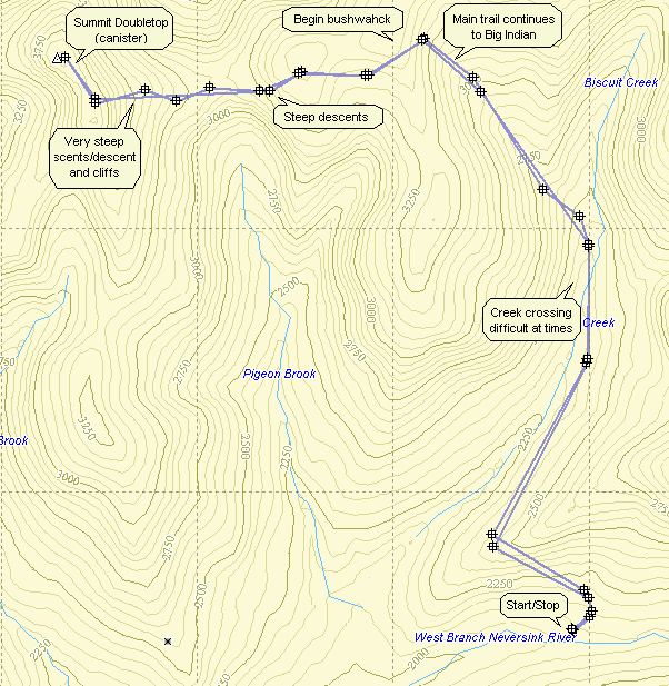
This route starts out on the blue-blazed Pine Hill West Branch Trail. Park at the Biscuit Brook parking
area on Ulster County Rt 47. Follow the trail toward Big Indian. Along the way is a lean-to in case you want to
stay over. The crossing of Biscuit Creek right after the lean-to can be a problem when the water is high.
After about 3.3 miles, the trail makes a sweeping left. Continue straight ahead to begin your bushwhack. You can
try any variation you want but descending into the col between the Big Indian ridge and Doubletop seems to
offer the most options. Some of the descents are steep and you will have to ascend these same slopes if you
are doing the out-and-back route. It is difficult to see Doubletop at most times so a GPS or a good compass
reading is a must. The ascent of Doubletop is steep in most places. What the contour maps do NOT show is
the numerous cliffs! You will have to find a way over or around them. As you ascend there are many instances
where you will think the summit is just ahead. Don't be fooled it is a difficult ascent! When you do get
to the top it is best to aim for a spot between the southern and northern summits. The canister is on the highest
point which is the north summit. You should be able to pick up a herd path at the top. Follow this path and
you will find the canister. The path does tend to wander some but the canister IS on the path and it beats
pushing through thick underbrush. Retrace your path to return. If you get an early start and have the stamina,
you can easily go to Big Indian and Fir.
(The map at the left shows the profile of the out and back route. Some of the steeper slopes near Doubletop are CLIFFS that must be navigated.)
| Quick Look - from Segar | ||||
|---|---|---|---|---|
| Difficulty | Round trip | Total climb | Location | Internet Maps |
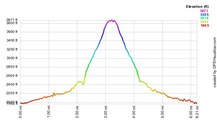
| 6.2 mi. | 2090 ft. | N42 01.63 W74 31.70 | AllTrails | |
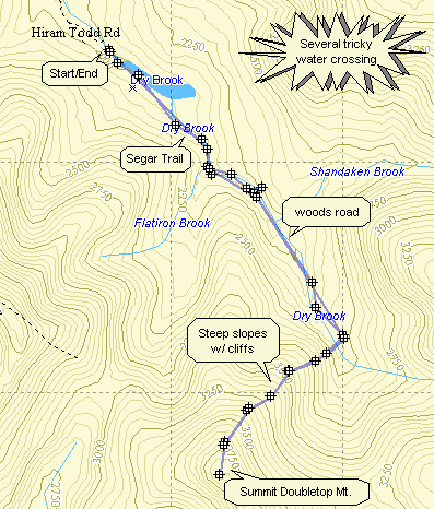
Arkville is located on Route 28 which runs from Kingston toward Delhi. It passes through some of the most notable hiking areas in the Catskills. In Arkville turn onto Dry Brook Rd. and stay on it for about 8.5 miles. At this point the road is not maintained and may be snow-covered in the winter. Continue about .5 miles to the trailhead parking area. Get on the yellow blazed Segar Trail. Be aware that much of the lad is private property owned by the Gould family. After about .8 miles and several small water crossing you will be at a bridge over Flat Iron Brook. Continue on the trail for another .5 miles. At this point the trail crosses a brook. During high water this crossing is all but impossible. If you cannot cross here, return to the bridge, cross the stream and bushwhack along the side hill until you get to the "impossible" crossing. At this point the Segar trail turns sharply left and goes up. Do not follow the trail but stay on the woods road. There will be several water crossings. The most difficult has a plank bridge to help you across. Whenever the woods road splits, stay to the right. You will see the lower peak of Doubletop in front of you and the higher peak to your right.
After about .7 miles, find a place to cut to the right and head southwest toward the higher peak. The climb is
only a little over a mile but difficult. There are at least three steep climbs up, over or around "cliffs" of rock.
These are interspersed with flat areas which allow you to get your breath but not for long! In the winter the
footing is almost non-existent. In the Spring and summer, the briars and nettles are in full "bloom". Near the top the
mountain finally levels off and you can wander around looking for the canister. Like most it is near the highest point,
on a tree in a small clearing. A GPS unit has always been helpful to me in finding the top and the can. The way back is
just a matter of retracing your path up. The whole trip is under 7 miles but involves an elevation gain from parking
area to peak of almost 2000 ft. Depending on your fitness level allow at least 6 hours for the round rip.