
MillBrook Ridge
| Trailhead Coordinates | |
|---|---|
| Name | Coordinates |
| Alder Lake | N42.0497 W74.6827 |
| Woodpecker Ridge | N42.0123 W74.6227 |
| Quick Look - Alder Lake to Millbrook Ridge (Out and Back) | ||||
|---|---|---|---|---|
| Difficulty | Round trip | Total climb | Location | Internet Maps |
 |
7.1 mi. | 1480 ft. | N42.0527 W74.6330 | AllTrails |
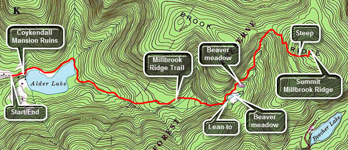
Take the Beaverkill Road from Livingston Manor and drive for about twenty minutes to the Alder Lake Road. Alder Lake Road is a left turn off the Beaverkill Road about two miles after it makes a sharp right turn near the Barkaboom Road that goes to the Little Pond State Campgrounds. Go to the end of Alder Lake Road and turn right into the access road to Alder Lake. Park in the parking lot and walk to the lake. The stately mansion house on the grounds was burned by the state several years ago leaving only the stonework behind. As you walk toward the lake bear left the red Alder Lake Loop Trail. After about .8 miles on this trail the yellow Mill Brook Ridge trail breaks off heading east. The trail ascends very gently and after about 1.5 miles on the trail you arrive at the Beaver Meadow lean-to and spring. There once was a large beaver pond here but it is now being reclaimed and forming a meadow.
Back on the trail you will pass another beaver meadow on your right after which the trail climbs more steeply. After about 1.35 miles you are at the highest point on the ridge (3480 ft). The return trip simply reverses your trip out. When you get to the Alder Lake loop trail, you can go the other way around to add a little variety. The shortest route is to retrace your steps.
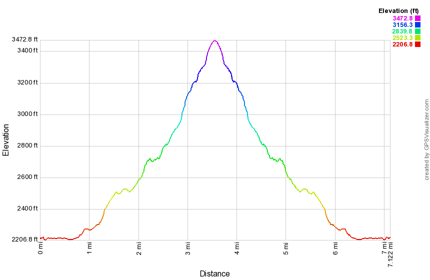 (The image shows the vertical profile of the entire out and back route.)
| Quick Look - Woodpecker Ridge to Millbrook Ridge to Alder Lake (One Way) | ||||
|---|---|---|---|---|
| Difficulty | Round trip | Total climb | Location | Internet Maps |
| 7.5 mi. | 2000 ft. | N42.0527 W74.6331 | AllTrails | |
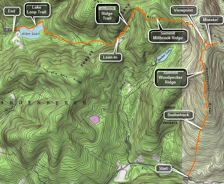
Woodpecker Ridge is one of the more western CHH peaks located in the Town of Hardenburgh in Ulster County. It is only accessible by bushwhacking. One way to hike this peak is to hike the Millbrook Ridge Trail that runs between Alder Lake and Balsam Lake Mountain. The high point on the ridge is less than a mile from where the Millbrook Ridge Trail passes by Woodpecker Ridge Another route is to park at the trailhead for the Mongaup Hardenburgh Trail and cross the road. From Livingston Manor (Exit 96 from I86) drive north and west on Old Route 17. Turn right on Beaverkill Road and continue on this road through the hamlets of Lew Beach and Turnwood. Watch for the road sign for Alder Creek Road on your left. Drive to the end of the road and turn right into the access road for Alder Lake. Park one car in the lot here. Drive back out to the Beaverkill Road and turn left to continue north. Watch for a sign for Cradle Rock Ridge on the right. Continue passed this sign until you see a small parking area for the beginning of the trail on your right. Park here and walk down the trail to the Beaverkill. Take some pictures of the suspension bridge over the river here. Return to your car, cross the road and enter the woods.
Head UP and almost due north for a little over two miles. The woods are mostly open with only a few rocky areas. Once the terrain flattens out it is a long walk to the highest point. There may be some viewpoints for Balsam Lake Mountain on the eastern side of the summit plateau. A little clearing opens up on top of the plateau. Continue due north until about 2.7 miles where you should hit the Millbrook Ridge trail. The MOST IMPORTANT thing to remember is to stay on the high ground of the ridge. Dropping off the ridge means you will simply have to regain that lost elevation. Turn left or west on the Millbrook ridge Trail. As you walk along the trail watch carefully for the marking as they sometimes are hard to spot. After a short distance there will be a lookout right on the trail. Below the lookout is Beecher Lake which has a Buddhist Monastery on its shores. There are also nice views of the surrounding hills. Continue your walk passing through a Col and climbing to the highest point on Millbrook Ridge at just under 4 miles into the hike. The elevation here is around 3470 feet leaving it 30 feet short of a Catskill 35. From here the trip to Alder Lake is all downhill with two minor bumps. At 5.25 miles there is a lean-to which looks out over a beaver meadow. This is a nice place to stop for a break before the final push to Alder Lake. Continue down the trail until you near Alder Lake and intersect the loop trail at 6.6 miles. Turn right and head around the lake to your car.
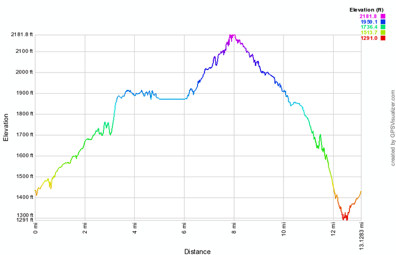 (The image shows the vertical profile of the entire one way hiking route.)