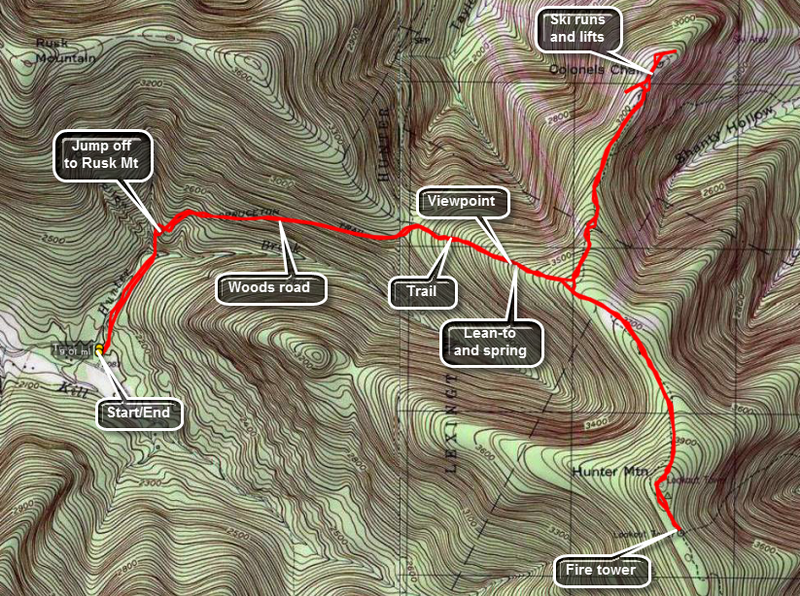
Hunter Mountain
Although it is the second highest peak, Hunter has not enjoyed the same popularity as Slide Mountain. It does, however, have several different approaches and a couple of these have viable options for forming a loop. Hunter also has a rather high state fire tower which, on a clear day. offers wonderful views of other 3500 foot peaks and the valleys between them.
A side trip to the Colonel's Chair is well worth the effort. This trail leads down the mountain descending 500 feet is a little over a mile. The payoff occurs when you arrive at the ski lift area for Hunter Mountain. The views of the mountains, the valleys and the Village of Hunter below are amazing.
| Trailhead Coordinates | |
|---|---|
| Name | Coordinates |
| Spruceton Road (first lot) | N42.1847 W74.2719 |
| Spruceton Road (second lot) | N42.1824 W74.2695 |
| Route 214 (Notch Lake) | N42.1595 W74.2034 |
| Becker Hollow | N42.1816 W74.1968 |
| Diamond Notch | N42.1498 W74.2647 |
| Quick Look (Loop from Becker Hollow) | ||||
|---|---|---|---|---|
| Difficulty | Round trip | Total climb | Location | Internet Maps |
| 7.5 mi. | 2045 ft. | N42.1775 W74.2308 | AllTrails | |
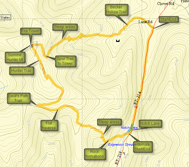
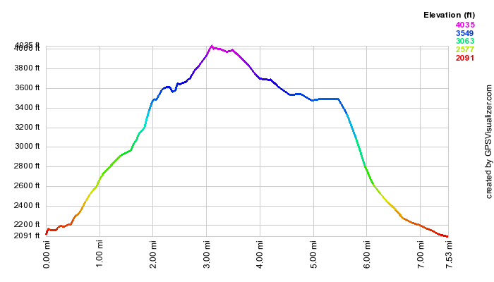
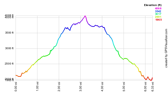
Park at the Devil's Tombstone State Campgrounds on Stony Clove Road (Rt 214)and pay the $5 seasonal parking fee. Find the red-blazed Devil's Path at the outlet end of Notch Lake. Cross the bridge and sign the trail register. The trail now ascend for about 1 mile and is steep at times. At the beginning there are some interesting rock formations and cliffs. The trail in this initial steep area has numerous switchbacks. After a mile the trail levels and continues for about another mile to the junction with the yellow Hunter Mountain Trail. Straight ahead on the devil's Path is the Devil's Acre lean-to. Turn right and ascend for about 1.5 miles to the junction with the blue Spruceton Trail that continues for .3 miles to the summit of Hunter Mountain and the fire tower. There are no views from the top unless you climb the tower. The observation cab may not be open but the views from just below it are good. You may now reverse your path and return to the Notch Lake parking area or descend the blue Becker Hollow Trail. To find the Becker Hollow Trail you can return to the junction with the Hunter Mountain Trail that you passed on the way up. You may also find the yellow spur trail that leads down through some rock ledges and joins the Becker Hollow Trail after about .3 miles. This trail descends for about 2.1 miles until it reaches the Becker Hollow trailhead. It is the shortest route up and down Hunter but one of the steepest with a lot of loose rock and dirt on the upper end. Near the bottom the trail levels out some and follows and old woods road. Watch your step on the descent but also watch for some nice views that pop up periodically. You will end up on Stony Clove Road about 1.5 miles north of the Devil's Tombstone and Notch Lake. Take a right and hike south on the road back to the car.
The other option for this route is to park at the Becker Hollow trailhead and ascend the Becker Hollow Trail. This is a steep and challenging ascent but some find going up easier than coming down. In this case you will descend the yellow Hunter Mountain Trail and then turn left on the red Devil's Path. The initial part of the Devil's Path is relatively flat. This is followed by the descent which becomes steep in some areas. You will end up on Stony Clove Road about 1.5 miles south of the Becker Hollow trailhead. Take a left and hike north on the road back to the car. Of course, you can use the Becker Hollow Trail for up AND down which is the shortest route to Hunter.
| Quick Look (Spruceton Out and Back) | ||||
|---|---|---|---|---|
| Difficulty | Round trip | Total climb | Location | Internet Maps |
| 7.2 mi. | 2050 ft. | N42 10.65 W74 13.85 | AllTrails | |
 Park at the large trailhead parking lot near the end of the Spruceton Road. This is the first of
three parking lots and each is smaller than the previous. Find the blue-blazed Spruceton Trail which
starts as a wide, gated road which follows Hunter Brook. After crossing a small bridge across the brook, you
will come to a hairpin turn to the right. Look to your right as you ascend this trail for imposing views of
West Kill. After 1.7 miles, the trail turns right off the road but remains fairly wide and well kept. In the
winter water from the spring can overflow the trail forming ice flows that can be dangerous. In the other
seasons this spring may cause the trail to be muddy. At the spring is a nice lookout which offers views of
Rusk Mountain, West Kill, and, farther off, North dome and Sherrill. The trail continues to the fire tower
at the summit with the total distance being about 1.7 miles from the turn. A trail to the Colonel's Chair at
the top of the Hunter Mountain Ski Area is clearly marked about halfway up the trail. Reverse your steps to
return or reverse the route below to make a loop.
Park at the large trailhead parking lot near the end of the Spruceton Road. This is the first of
three parking lots and each is smaller than the previous. Find the blue-blazed Spruceton Trail which
starts as a wide, gated road which follows Hunter Brook. After crossing a small bridge across the brook, you
will come to a hairpin turn to the right. Look to your right as you ascend this trail for imposing views of
West Kill. After 1.7 miles, the trail turns right off the road but remains fairly wide and well kept. In the
winter water from the spring can overflow the trail forming ice flows that can be dangerous. In the other
seasons this spring may cause the trail to be muddy. At the spring is a nice lookout which offers views of
Rusk Mountain, West Kill, and, farther off, North dome and Sherrill. The trail continues to the fire tower
at the summit with the total distance being about 1.7 miles from the turn. A trail to the Colonel's Chair at
the top of the Hunter Mountain Ski Area is clearly marked about halfway up the trail. Reverse your steps to
return or reverse the route below to make a loop.
| Quick Look (Spruceton with Colonel's Chair) | ||||
|---|---|---|---|---|
| Difficulty | Round trip | Total climb | Location | Internet Maps |
| 9.1 mi. | 2888 ft. | N42 10.65 W74 13.85 | AllTrails | |
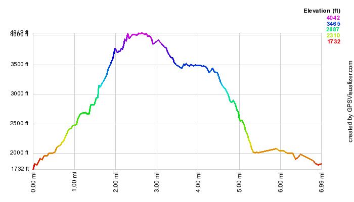
 Park at the large trailhead parking lot near the end of the Spruceton Road. This is the first of
three parking lots and each is smaller than the previous. Find the blue-blazed Spruceton Trail which
starts as a wide, gated road which follows Hunter Brook. After crossing a small bridge across the brook, you
will come to a hairpin turn to the right. Look to your right as you ascend this trail for imposing views of
West Kill. After 1.7 miles, the trail turns right off the road but remains fairly wide and well kept. In the
winter water from the spring can overflow the trail forming ice flows that can be dangerous. In the other
seasons this spring may cause the trail to be muddy. At the spring is a nice lookout which offers views of
Rusk Mountain, West Kill, and, farther off, North dome and Sherrill. The trail continues to the fire tower
at the summit with the total distance being about 1.7 miles from the turn.
Park at the large trailhead parking lot near the end of the Spruceton Road. This is the first of
three parking lots and each is smaller than the previous. Find the blue-blazed Spruceton Trail which
starts as a wide, gated road which follows Hunter Brook. After crossing a small bridge across the brook, you
will come to a hairpin turn to the right. Look to your right as you ascend this trail for imposing views of
West Kill. After 1.7 miles, the trail turns right off the road but remains fairly wide and well kept. In the
winter water from the spring can overflow the trail forming ice flows that can be dangerous. In the other
seasons this spring may cause the trail to be muddy. At the spring is a nice lookout which offers views of
Rusk Mountain, West Kill, and, farther off, North dome and Sherrill. The trail continues to the fire tower
at the summit with the total distance being about 1.7 miles from the turn.
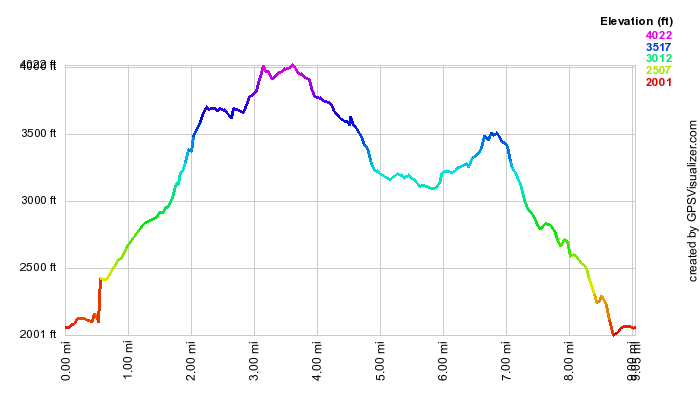
A trail to the Colonel's Chair at the top of the Hunter Mountain Ski Area is clearly marked about .3 miles from the spring. I prefer to do this on the return trip. Continue on the main trail 1.25 miles to the summit and the fire tower. The summit has no views except those from the tower. However, the views from the tower are very good on a clear day. Unfortunately, many days are cloudy or hazy! When you are ready, go back down the Spruceton Trail until you get to the yellow blazed Colonel's Chair Trail. Be prepared to drop about 500 feet of elevation over the 1.1 miles to the ski lifts at the top of Hunter Mountain Ski Area. As you walk you will notice colored and numbered trails. These are used for snowshoeing and mountain biking. Stay on the main trail which turns into a dirt road. You will pass on open area on your left which is a stone quarry. A little further on the right is a lookout and a sculpture of Rip VanWinkle. If you miss this, you can follow the signs from the ski lifts. Stay on the trail until you start to see ski lifts. At this point you can walk around to the top of the various lifts and slopes. The views of the surrounding mountains and those in the distance are beautiful. There are also great views of the village of Hunter in the valley below. Reverse your steps to climb back up to the main trail. Turn right onto the Spruceton Trail to get back to the parking area.
| Quick Look (Loop from Spruceton) | ||||
|---|---|---|---|---|
| Difficulty | Round trip | Total climb | Location | Internet Maps |
| 7.9 mi. | 2110 ft. | N42 10.65 W74 13.85 | AllTrails | |
 Park at the large trailhead parking lot near the end of the Spruceton Road. This is the first of
three parking lots and each is smaller than the previous. Find the blue-blazed Spruceton Trail which
starts as a wide, gated road which follows Hunter Brook. After crossing a small bridge across the brook, you
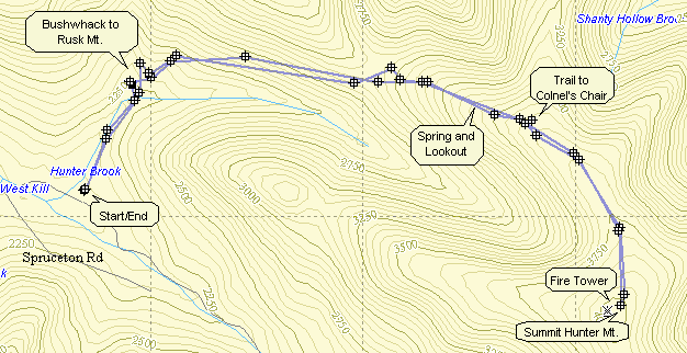
will come to a hairpin turn to the right. In this area you can cross the brook and head northwest to
bushwhack Rusk Mt. Look to your right as you ascend the trail after the hairpin for imposing views of
West Kill. After 1.7 miles, the trail turns right off the road but remains fairly wide and well kept. In the
winter water from the spring can overflow the trail forming ice flows that can be dangerous. In the other
seasons this spring may cause the trail to be muddy. Just above the spring is a nice lookout which offers
views of Rusk Mountain, West Kill, and, farther off, North dome and Sherrill. This area was the location
of the John Robb lean-to which has since fallen victim to fire. The trail continues to the fire tower
at the summit with the total distance being about 1.7 miles from the turn. A trail to the Colonel's Chair at
the top of the Hunter Mountain Ski Area is clearly marked about halfway up the trail.
Park at the large trailhead parking lot near the end of the Spruceton Road. This is the first of
three parking lots and each is smaller than the previous. Find the blue-blazed Spruceton Trail which
starts as a wide, gated road which follows Hunter Brook. After crossing a small bridge across the brook, you
will come to a hairpin turn to the right. In this area you can cross the brook and head northwest to
bushwhack Rusk Mt. Look to your right as you ascend the trail after the hairpin for imposing views of
West Kill. After 1.7 miles, the trail turns right off the road but remains fairly wide and well kept. In the
winter water from the spring can overflow the trail forming ice flows that can be dangerous. In the other
seasons this spring may cause the trail to be muddy. Just above the spring is a nice lookout which offers
views of Rusk Mountain, West Kill, and, farther off, North dome and Sherrill. This area was the location
of the John Robb lean-to which has since fallen victim to fire. The trail continues to the fire tower
at the summit with the total distance being about 1.7 miles from the turn. A trail to the Colonel's Chair at
the top of the Hunter Mountain Ski Area is clearly marked about halfway up the trail.
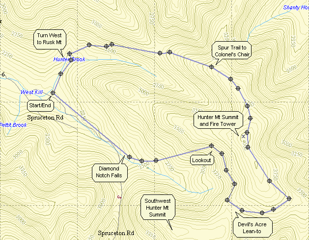
After the fire tower, find the yellow-blazed Hunter Trail that leads to the Devil's Acre lean-to.
This trail intersects the red-blazed Devil's Path after about 1.35 miles. Turn right onto the Devil's Path
and the lean-to is just a short distance away. Just passed the lean-to is a small stream and then a ribbon
of cinders that cross the trail. This is the remains of a cog railway that went to the summit at one point.
Following this ribbon to the left will lead you to a rock cairn after less than a mile. Turning right and
up at this point will lead you to the peak of Southwest Hunter. As you continue on the Devil's Path there are
several short climbs before the trail starts its descent. After about .5 miles there is a short trail to the
left that offers a splendid lookout. The descent along the Devil's Path is steep at times with many unstable
rocks. One mile after the lean-to is the junction with the Diamond Notch Trail and a beautiful waterfall;
Diamond Notch falls. Follow the blue-blazed Diamond Notch Trail along the West Kill to Spruceton Road.
After one mile you will be back at the parking area.