
Cornell Mountain
Cornell is the middle mountain in the Wittenberg Cornell Slide chain and can be climbed on a hike that includes all three. This is probably the best way to approach the mountain. Those who do not want to attempt the 14 mile round trip can park a car at each end of the 9 mile trail. If you do not want to complete the round trip, you may hike over either Slide or Wittenberg to get to Cornell and then reverse your hike on the return trip.
| Trailhead Coordinates | |
|---|---|
| Name | Coordinates |
| Route 47 (Slide PA) | N42.0090 W74.4275 |
| Denning PA | N41.9654 W74.4527 |
| Woodland Valley | N42.0361 W74.3575 |
| Route 47 (Panther PA) | N42.0266 W74.4037 |
| Quick Look - Slide and Cornell from Rt 47 | ||||
|---|---|---|---|---|
| Difficulty | Round trip | Total climb | Location | Internet Maps |
| 9.7 mi. | 3360 ft.) | N42.0014 W74.3572 | AllTrails | |
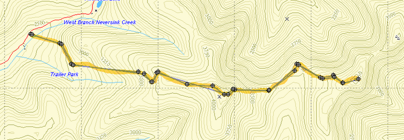
Park at the trailhead and cross the West Branch of the Neversink River. When it has rained or there is snowmelt, it may be impossible to cross without getting wet. At other times, this area is completely dry. Find the yellow blazed Phoenicia-East Branch trail and begin a gentle ascent of about .75 miles. At this point turn left onto the red-blazed Wittenberg Cornell Slide Trail. Continue on this trail for about 2.1 miles. Pass over the actual summit and continue on to the rocky prominence and lookout where most hikers rest. Enjoy the view of the Ashokan Reservoir and the surrounding valley and mountains. Continue down Slide to the col between Slide and Cornell. This is a steep descent of about .85 miles. Various "staircases" of stone and wood make the descent a little easier. After going down some of these, look to your left for a short trail that lead to a nice spring. From the col, ascend 1.4 miles to the top of Cornell. Be sure to take the short spur trail to your right which leads to the actual summit. Reverse your trip to return to the parking area.
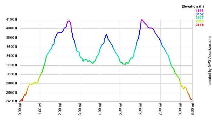
| Quick Look - Wittenberg and Cornell from Woodland Valley | ||||
|---|---|---|---|---|
| Difficulty | Round trip | Total climb | Location | Internet Maps |
| 9.0 mi. | 3940 ft. | N42 00.08 W74 21.43 | AllTrails | |
Park at the Woodland Valley State Campgrounds and pay a seasonal parking fee. Follow the red markers to the red-blazed trail. Immediately the trail gives you a hint of what is to come. There is an ascent to even get to the log book! After 3.9 miles of ascent including some interesting rock scrambles, you arrive at the top of Wittenberg Mountain. Wittenberg offers one of the finest lookout in the Catskills and is well worth the effort. The trail now descends into the col between Wittenberg and Cornell and then ascends to the summit of Cornell, a total distance of .85 miles. Be sure to take the short spur trail at the top of Cornell to actually reach the highest point on the mountain. Reverse your trip to return to the parking area.
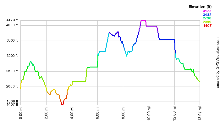
(The image above is the vertical profile for the out-and-back hike)
| Quick Look (Burroughs Range Loop) | ||||
|---|---|---|---|---|
| Difficulty | Round trip | Total climb | Location | Internet Maps |
| 14.6 mi. (round trip) | 2430 ft. | N42 00.50 W74 20.85 | All Trails | |
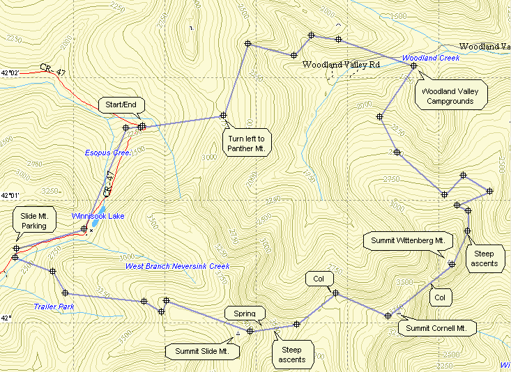
The round trip loop over all three peaks in the Burroughs Range is 14 miles with many challenging rock scrambles. This loop traverses Wittenberg, Cornell and Slide. Many people park one car at each end of the trail which cuts the distance to just over nine miles. Parking is available on RT 47 at the Panther Mountain or Slide Mountain trail head. Parking at Woodland Valley State Campgrounds is also possible but there may be a seasonal parking fee.
From Woodland Valley follow the red markers through the campsites to the bridge over the stream and to the red-blazed trail. Immediately the trail gives you a hint of what is to come. There is an ascent to even get to the log book! After 3.9 miles of ascent including some interesting rock scrambles, you arrive at the top of Wittenberg Mountain. Wittenberg offers one of the finest lookout in the Catskills and is well worth the effort. The trail now descends into the col between Wittenberg and Cornell and then ascends to the summit of Cornell, a total distance of only .85 miles. Be sure to take the short spur trail to the left at the top of Cornell to actually reach the highest point on the mountain. The trail now descends to the col between Cornell and Slide which is reached after about 1.4 miles. As you begin the steep climb up Slide, look to the right as you ascend the rock and wood "staircases". A short trail leads to a spring which also affords a nice view back at Cornell. After about .85 miles from the col, you will be at the Slide Mountain lookout. From here you can return the way you came but this would mean hiking five 3500's in one day! You can continue on the trail for about 2.85 miles to the Slide Mountain parking area on the Frost Valley Road. (If you planned ahead and parked a car at this end of the trail, your hike is over.) From here you will need to hike 2 miles on the road to the hairpin turn passed Winisook Lake. At this point you turn right onto the Phoenicia - East Branch Trail. Follow this yellow-blazed trail for 3.4 miles back to the parking area in Woodland Valley.
From the Panther Mountain parking area on Rt 47, cross the road and get on the yellow blazed Phoenicia - East Branch Trail. Follow this yellow-blazed trail for 3.4 miles to the parking area in Woodland Valley. From Woodland Valley follow the red markers through the campsites to the bridge over the stream and to the red-blazed trail. Immediately the trail gives you a hint of what is to come. There is an ascent to even get to the log book! After 3.9 miles of ascent including some interesting rock scrambles, you arrive at the top of Wittenberg Mountain. Wittenberg offers one of the finest lookout in the Catskills and is well worth the effort. The trail now descends into the col between Wittenberg and Cornell and then ascends to the summit of Cornell, a total distance of only .85 miles. Be sure to take the short spur trail to the left at the top of Cornell to actually reach the highest point on the mountain. The trail now descends to the col between Cornell and Slide which is reached after about 1.4 miles. As you begin the steep climb up Slide, look to the right as you ascend the rock and wood "staircases". A short trail leads to a spring which also affords a nice view back at Cornell. After about .85 miles from the col, you will be at the Slide Mountain lookout. From here you can return the way you came but this would mean hiking five 3500's in one day! You can continue on the trail for about 2.85 miles to the Slide Mountain parking area on the Frost Valley Road. From here you will need to hike 2 miles on the road back to the Panther Mountain parking area at the hairpin turn passed Winisook Lake.
From the Slide Mountain trailhead on Route 47 cross the West Branch of the Neversink River. When it has rained or there is snowmelt, it may be impossible to cross without getting wet. At other times, this area is completely dry. Find the yellow blazed Phoenicia-East Branch trail and begin a gentle ascent of about .75 miles. At this point turn left onto the red-blazed Wittenberg Cornell Slide Trail. Continue on this trail for about 2.1 miles. Pass over the actual summit and continue on to the rocky prominence and lookout where most hikers rest. Enjoy the view of the Ashokan Reservoir and the surrounding valley and mountains. The trail now descends to the col between Slide and Cornell which is reached after about .85 miles. As you begin the steep descent down Slide on the wooden "ladders", look to the left as you descend the rock and wood "staircases". A short trail leads to a spring which also affords a nice view back at Cornell. After about 1.4 miles from the col, you will be at the summit of Cornell Mountain. Be sure to take the short spur trail to the right at the top of Cornell to actually reach the highest point on the mountain and a nice viewpoint. The trail now descends into the col between Cornell and Wittenberg and then ascends to the summit of Wittenberg. The total distance is only .85 miles. Wittenberg offers one of the finest lookout in the Catskills and is well worth the effort. The red trail now descends 3.9 miles you will be at Woodland Valley State Campgrounds. Cross over to the other side walking through the campgrounds and parking area. Find and follow the yellow-blazed trail for 3.4 miles to the Panther Mountain parking area. At the junction with Rt 47 turn left and hike up the hill and then back to the Slide Mountain parking area a distance of 2.0 miles.
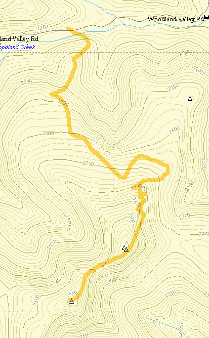
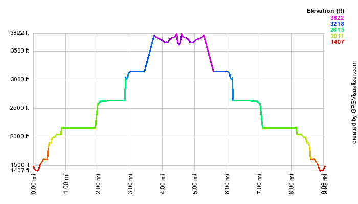
| Quick Look (Burroughs Range Out and Back from Rt 47) | ||||
|---|---|---|---|---|
| Difficulty | Round trip | Total climb | Location | Internet Maps |
| 10.0 mi. | 3932 ft. | N41 59.95 W74 23.17 | AllTrails | |
This version of the hike includes all three peaks of the Burroughs range as an out-and-back hike. This means scaling 5 peaks along the way!
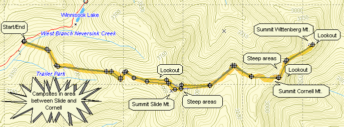
Park at the trailhead on the Frost Valley Road (Ulster County Rt. 47) and cross the West Branch of the Neversink River. When it has rained or there is snowmelt, it may be impossible to cross without getting wet. At other times, this area is completely dry. Find the yellow blazed Phoenicia-East Branch trail and begin a gentle ascent of about .75 miles. At this point turn left onto the red-blazed Wittenberg Cornell Slide Trail. Continue on this trail for about 2.1 miles. Pass over the actual summit of Slide Mountain where the anchors for the old fire tower mark the highest point on the mountain. Continue on to the rocky prominence and lookout where most hikers rest. Enjoy the view of the Ashokan Reservoir and the surrounding valley and mountains.
Continue on the trail down the other side of Slide. The descent is marked by some interesting rock scrambles and wooden ladders built into the side of the mountain. After descending .2 miles, right after the ladders, look for a short spur trail to the left that leads to a spring. Another .65 miles brings you to the Col between Slide and Cornell. The descent is difficult in spots with several nearly vertical areas. Remember that what you descend now you must ascend on the way back! Now the ascent of Cornell begins. After 1.4 miles a short trail leads off to the right to the summit of Cornell. There is also a nice lookout over the Ashokan Reservoir and Wittenberg Mountain. The ascent is marked by several steep areas and areas that require climbing up and over a series of boulders.
The descent to the col between Cornell and Wittenberg is only .5 miles but is very difficult with one vertical chimney. From the col the ascent of Wittenberg is only .35 miles and in relatively easy. The open rock shelf on Wittenberg has some of the best views in the Catskills. Cornell and Slide are visible as well as many other peaks. Terrace Mountain can be seen and the view of the Ashokan is unmatched. To complete the hike, retrace your path back over Cornell and Slide!
 From here you may want to continue for about .2 miles down the other side of Slide to a small spring.
Be aware that the descents and subsequent ascents are steep at points requiring some short rock scrambles.
From here you may want to continue for about .2 miles down the other side of Slide to a small spring.
Be aware that the descents and subsequent ascents are steep at points requiring some short rock scrambles.